
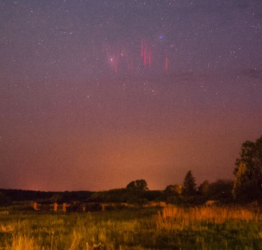
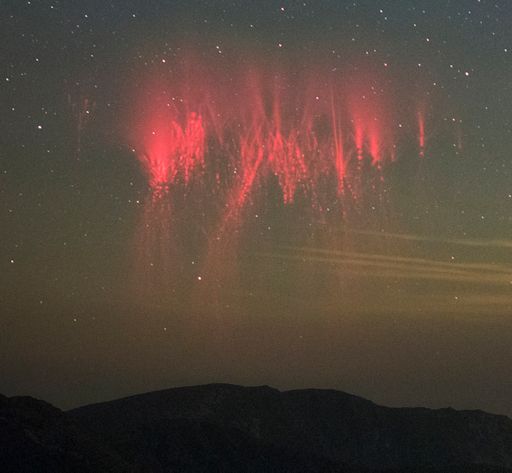
SPRITE SEASON BEGINS: High above Earth in the realm of meteors and noctilucent clouds, a strange and beautiful form of lightning dances at the edge of space. Researchers call the bolts "sprites"; they are red, fleeting, and tend to come in bunches. Note to sky watchers: Sprite season is underway. Martin Popek photographed these specimens over Nydek, Czech republic, on May 13th:
One night later, May 14th, near Santa Fe, New Mexico, "I captured my first sprites of the season," reports photographer Jan Curtis. "The thunderstorm that produced them was about 200 miles to my south-southwest."
Because sprites are associated with thunderstorms, they tend to occur in late spring and summer. Thunderstorm season is sprite season.
"Sprites are a true space weather phenomenon," explains lightning scientist Oscar van der Velde of the Technical University of Catalonia, Spain. "They develop in mid-air around 80 km altitude, growing in both directions, first down, then up. This happens when a fierce lightning bolt draws lots of charge from a cloud near Earth's surface. Electric fields [shoot] to the top of Earth's atmosphere--and the result is a sprite. The entire process takes about 20 milliseconds."
Although sprites have been seen for at least a century, most scientists did not believe they existed until after 1989 when sprites were photographed by cameras onboard the space shuttle. Now "sprite chasers" routinely photograph sprites from their own homes. "I used up a Watec 910HX security camera with UFOCapturesoftware to catch my sprites," says Popek. Give it a try!
bron:http://www.spaceweather.com/ | Gewijzigd: 30 januari 2017, 12:37 uur, door Joyce.s
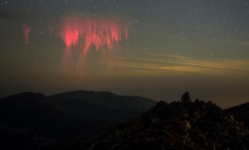
SPRITES OVER OKLAHOMA:
On Saturday night, May 23rd, strong thunderstorms raked Texas and Oklahoma, producing torrential rains and deadly floods. Amateur astronomer Thomas Ashcraft could see the lightning bolts all the way from New Mexico--and not all of them were going down. "There was a bright display of sprites shooting up from the tops of the thunderclouds," says Ashcraft. He took this picture using a near-infrared camera at his observatory outside Santa Fe:
Sprites are an exotic form of lightning that appear very high above Earth's surface, at the edge of space itself.
"Sprites are a true space weather phenomenon," says lightning scientist Oscar van der Velde of the Technical University of Catalonia, Spain. "They develop in mid-air around 80 km altitude, growing in both directions, first down, then up. This happens when a fierce lightning bolt draws lots of charge from a cloud near Earth's surface. Electric fields [shoot] to the top of Earth's atmosphere--and the result is a sprite."
How exotic are they? This close-up view of the Oklahoma sprites says it all:
Turn up the volume," advises Ashcraft. "In the movie you can hear the very low frequency radio crackles from individual lightning strokes."
Although sprites have been seen for at least a century, most scientists did not believe they existed until after 1989 when sprites were photographed by cameras onboard the space shuttle. Now "sprite chasers" routinely photograph sprites from their own homes.
bron: http://www.spaceweather.com/ | Gewijzigd: 30 januari 2017, 12:37 uur, door Joyce.s
Ze zijn weer gespot, sprites !
"SPACE LIGHTNING" OVER TEXAS:
You know what comes out of the bottom of thunderstorms: lightning. On April 27th, Kevin Palivec of Hawley, Texas, saw something coming out of the top. "Storms moving across Texas produce more than just rain, wind, hail and tornadoes!" says Palivec. "They also produce a lot of space lightning called 'sprites.' This is a stacked image of all the sprites I caught over storms as they moved across Texas towards Dallas/Ft Worth--with one meteor thrown in!"
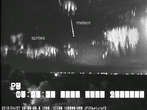
Because sprites are associated with thunderstorms, they tend to occur in late spring and summer. Palivec's photo shows that sprite season is now underway.
Sprites are a true space weather phenomenon, inhabiting the upper reaches of Earth's atmosphere alongside noctilucent clouds, meteors, and some auroras. Some researchers believe they are linked to cosmic rays: subatomic particles from deep space striking the top of Earth's atmosphere produce secondary electrons that, in turn, could provide the spark that triggers sprites.
"Sprites develop in mid-air very high above Earth's surface, around 80 km altitude, growing in both directions, first down, then up," says explains lightning scientist Oscar van der Velde of the Technical University of Catalonia, Spain. "An individual sprite lasts only around 5-50 milliseconds but a sequence of them can be seen to 'dance' over storm fronts for a much longer period of time."
Although sprites have been seen for at least a century, most scientists did not believe they existed until after 1989 when sprites were photographed by cameras onboard the space shuttle. Now "sprite chasers" routinely photograph sprites from their own homes. Give it a try!
Bron: http://www.spaceweather.com/
Red sprites and green airglow:
Thunderstorm season is underway in the northern hemisphere. That means astrophotographers should point their cameras above the clouds. Thomas Ashcraft did so on June 14th, and he captured two forms of space weather--red sprites and green airglow:
"A large jellyfish sprite appeared over a thunderstorm in the western Oklahoma panhandle last evening," says Ashcraft. "It was about three hundred miles away from my observatory."
"I also caught it in video with very low frequency (VLF) radio emissions, and the parent lightning stroke made a strong pop," he says. Turn up the volume and play the video.
Possibly triggered by cosmic rays, sprites are a form of upper atmospheric that reach up from the tops of thunderstorms toward the edge of space. Although sprites have been seen for at least a century, most scientists did not believe they existed until after 1989 when sprites were photographed by cameras onboard the space shuttle.
The "jellyfish sprite" Ashcraft captured is backlit by a band of green airglow. Airglow surrounds our entire planet, fringing the top of the atmosphere with aurora-like color. Although airglow resembles the aurora borealis, its underlying physics is different. Airglow is caused by an assortment of chemical reactions in the upper atmosphere. Auroras, on the other hand, are ignited by gusts of solar wind.
Bron: http://www.spaceweather.com/ | Gewijzigd: 30 januari 2017, 12:37 uur, door Joyce.s
Sprites boven Tsjechië gefotografeerd
Summer thunderstorm season is underway in Europe. As a result, space lightning is on the rise. Martin Popek photographed these specimens over Nýdek in the Czech republic on July 10th:
These are sprites--an exotic form of upper atmospheric electricity sometimes called "space lightning" because they reach altitudes associated with meteors, noctilucent clouds and auroras. Some researchers believe they are linked to cosmic rays: Subatomic particles from deep space striking the top of Earth's atmosphere produce secondary electrons that, in turn, could provide the spark that triggers sprites.
Although sprites have been seen for at least a century, most scientists did not believe they existed until after 1989 when sprites were photographed by cameras onboard the space shuttle. Now "sprite chasers" routinely photograph sprites from their own homes. "They are easily detected by certain cameras," says lightning scientist Oscar van der Velde of the Technical University of Catalonia, Spain. "If a storm is in the mood, you may record one every few minutes." Give it a try!
Bron: http://www.spaceweather.com/ | Gewijzigd: 30 januari 2017, 12:37 uur, door Joyce.s
"A- bomb" sprite over the Caribbean
Yesterday, Frankie Lucena of Cabo Rojo, Puerto Rico, photographed an enormous 'A-bomb' sprite over the Carribean Sea. For a split-second, the sky lit up like this:Oscar van der Velde, a member of the Lightning Research Group at the Universitat Politècnica de Catalunya, explains what Lucena phtographed:
"This type of sprite is often called 'jellyfish' or 'A-bomb,' and ranks as the largest type of sprite in both horizontal and vertical dimensions," he says. "It consists of a bright halo approximately 85 km above Earth's surface surrounding sprite elements with long tendrils reaching down as low as ~30 km above ground level."
"This kind of sprite tends to be triggered by a very impulsive positive cloud-to-ground flash," van der Velde adds.
The curious thing is, Lucena did not observe an instigating lightning bolt. Instead, just before the sprite appeared, he recorded a bright point-like flash of light. "Was it a cosmic ray hitting the camera?" wonders Lucena. Play the entire video to see the flash. Another possibility: The point-like flash could have been a cloud-to-ground strike mostly eclipsed by intervening clouds.
If Lucena did photograph something new triggering a sprite, perhaps it shouldn't come as a big surprise. The field is relatively new. Although sprites have been seen for at least a century, most scientists did not believe they existed until after 1989 when sprites were photographed by cameras onboard the space shuttle. There is still much to learn...
Bron: http://www.spaceweather.com/
High above Earth in the realm of meteors and noctilucent clouds, a strange and beautiful form of lightning dances at the edge of space. Researchers call the bolts "sprites"; they are red, fleeting, and tend to come in bunches. Note to sky watchers: Sprite season is underway. On May 19th, Laura Kranich photographed these specimens over Ziethen, Brandenburg, Germany:
© Laura Kranich
"The sprites appeared over a mesoscale convective system that moved through northern Germany," says Kranich. "I drove to eastern Germany to find a clear sky and to get a more distant view of the storm. (Distance can help see over the cloudtops.)"
Because sprites are associated with thunderstorms, they tend to occur in late spring and summer. Thunderstorm season is sprite season.
"Sprites are a true space weather phenomenon," explains lightning scientist Oscar van der Velde of the Technical University of Catalonia, Spain. "They develop in mid-air around 80 km altitude, growing in both directions, first down, then up. This happens when a fierce lightning bolt draws lots of charge from a cloud near Earth's surface. Electric fields [shoot] to the top of Earth's atmosphere--and the result is a sprite. The entire process takes about 20 milliseconds."
Although sprites have been seen for at least a century, most scientists did not believe they existed until after 1989 when sprites were photographed by cameras onboard the space shuttle. Now "sprite chasers" routinely photograph sprites from their own homes. Give it a try!
Bron: http://www.spaceweather.com/
RED SPRITES OVER EUROPE:
High above thunderstorms in Europe, red spritesare dancing across the cloudtops. Martin Popek of Nýdek, Czech republic, photographed these specimens on June 1st:
©Martin Popek
"The transient forms were shooting up from a storm in Slovenia," says Popek.
Reaching up to the edge of space, sprites are a true space weather phenomenon. Some researchers believe they are linked to cosmic rays: subatomic particles from deep space striking the top of Earth's atmosphere produce secondary electrons that, in turn, provide the spark that triggers sprites. If this is true, then sprites could multiply in the years ahead as cosmic rays intensify due to the decline of the solar cycle.
Although sprites have been seen for at least a century, most scientists did not believe they existed until after 1989 when sprites were photographed by cameras onboard the space shuttle. Now "sprite chasers" routinely photograph sprites from their own homes. "I used up a Watec 910HX security camera with UFOCapturesoftware to catch my sprites," says Popek.
Bron: http://www.spaceweather.com/
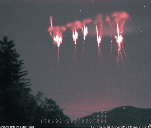
JELLYFISH SPRITES OVER EUROPE:
On June 20th, a thunderstorm in Austria unleashed a spectacular display of lightning. Observers on the ground witnessed blinding flashes of crackling light. The most amazing aspect of the outburst, however, was to be found high above the clouds. 80 km high, to be exact, in the realm of the sprites
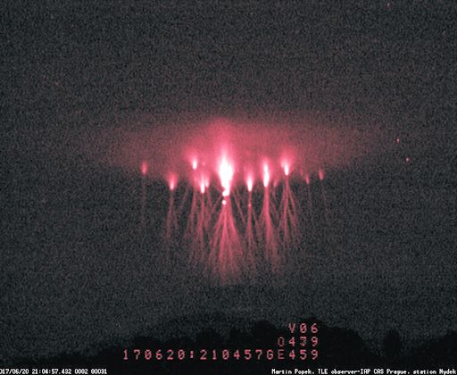
Martin Popek photographed the display from his private observatory in Nýdek, Czechia, more than 500 km away from the storm. Such distances are ideal for seeing above the tops of towering thunderclouds: diagram.
"Jellyfish sprite events like these are produced by very impulsive cloud-to-ground lightning flashes draining positive charge from the stratiform rain region in large thunderstorms," explains lightning scientist Oscar van der Velde of the Technical University of Catalonia, Spain. Somehow, in a process that researchers only partially understand, the resulting electric fields draw jellyfish forms out of the cloudtops.
The tops of the sprites were surrounded by a saucer-like halo of red light, notes van der Velde. "The halo is evidence of intense electric fields at 80-90 km shaking up the electrons (colliding with nitrogen to produce light) for such a short time that sprite streamers cannot form. At lower altitudes the field exists longer, allowing the jellyfish sprite streamers to grow from electron avalanches."
Although sprites have been seen for at least a century, most scientists did not believe they existed until after 1989 when sprites were photographed by cameras onboard the space shuttle. Now "sprite chasers" routinely photograph sprites from their own homes. "I used up a Watec 910HX security camera with UFOCapturesoftware to catch my sprites," says Popek. Give it a try!
Bron: http://www.spaceweather.com/
On June 20th, a thunderstorm in Austria unleashed a spectacular display of lightning. Observers on the ground witnessed blinding flashes of crackling light. The most amazing aspect of the outburst, however, was to be found high above the clouds. 80 km high, to be exact, in the realm of the sprites
Martin Popek photographed the display from his private observatory in Nýdek, Czechia, more than 500 km away from the storm. Such distances are ideal for seeing above the tops of towering thunderclouds: diagram.
"Jellyfish sprite events like these are produced by very impulsive cloud-to-ground lightning flashes draining positive charge from the stratiform rain region in large thunderstorms," explains lightning scientist Oscar van der Velde of the Technical University of Catalonia, Spain. Somehow, in a process that researchers only partially understand, the resulting electric fields draw jellyfish forms out of the cloudtops.
The tops of the sprites were surrounded by a saucer-like halo of red light, notes van der Velde. "The halo is evidence of intense electric fields at 80-90 km shaking up the electrons (colliding with nitrogen to produce light) for such a short time that sprite streamers cannot form. At lower altitudes the field exists longer, allowing the jellyfish sprite streamers to grow from electron avalanches."
Although sprites have been seen for at least a century, most scientists did not believe they existed until after 1989 when sprites were photographed by cameras onboard the space shuttle. Now "sprite chasers" routinely photograph sprites from their own homes. "I used up a Watec 910HX security camera with UFOCapturesoftware to catch my sprites," says Popek. Give it a try!
Bron: http://www.spaceweather.com/
SPRITE-Y NIGHT IN SLOVAKIA:
It was a dark and stormy night. After sunset on Friday, Aug. 18th, photographer Ondrej Kralik was hiking through the Low Tatras, a mountain range in central Slovakia. He could see stars overhead, but the horizon was flashing with the impulsive glow of lightning. "I thought a storm was coming," says Kralik, who trained his camera in the direction of the flashes. Instead of capturing the downward strike of lightning, however, he saw sprites:
"I quickly realized that the storm was far away, and I could see over the top of the thunderheads. Sprites were dancing along the cloudtops," says Kralik. "I saw this bright cluster of sprites with the naked eye and my camera captured it as well. Its brightness is approximately -6.7 mag, and it was located about 510 km far above southeast Germany."
"In the foreground under the sprites you can see the main ridge of Low Tatras, (Chabenec 1995 m) and Kotliska (1937 m) on the left," he says. "I was lucky to witness one of the brightest sprites, but as they say, fortune favors the prepared."
Sometimes called "space lightning," sprites are a true space weather phenomenon. They inhabit the upper atmosphere alongside auroras, meteors and noctilucent clouds. Some researchers believe they are linked to cosmic rays: subatomic particles from deep space striking the top of Earth's atmosphere produce secondary electrons that, in turn, kickstart sprites in the highly-charged environment above thunderstorms.
The link to cosmic rays is particularly interesting at this time. For the past two years, space weather balloons have observed a steady increase in cosmic rayspenetrating our atmosphere. This increase is largely due to the decline of the solar cycle. Flagging solar wind pressure and weakening sunspot magnetic fields allow more cosmic rays into the inner solar system--a trend which is expected to continue for years to come.
Bron: http://www.spaceweather.com/
A NEW KIND OF SPRITE?
Barely 30 years ago, many researchers did not believe that upper atmospheric lightning existed—until 1989 when researchers from the University of Minnesota captured them on video tape. Now there is a menagerie of accepted forms: sprites, elves, gigantic jets, gnomes. These "transient luminous events" (TLEs) appear above thunderclouds, reaching toward space rather than lancing down to the ground like regular lightning.
On Aug.14th, Thomas Ashcraft may have spotted a new kind of sprite. "I was photographing a cluster of sprites over a thunderstorm in western Oklahoma when something curved snaked up behind the main cluster." This frame from his video of the event shows the strange form:
What was it? Experts aren't sure.
Lightning researcher Oscar van der Velde at the Technical University of Catalonia says it could be a troll—a type of TLE that sometimes appears underneath sprites, crawling up tendrils dangling beneath the luminous clusters. "I have recorded many trolls," says van der Velde, "but never such weird curving ones. This is a really exceptional display."
Jozsef Bo'r of the Geodetic and Geophysical Research Institute in Hungary thinks it might be a type of gigantic jet. Gigantic jets are like sprites on steroids—powerful and bright. "A working hypothesis is that the red sprites in the photo occurred first and deposited a cloud of positive charge above the thundercloud. A subsequent gigantic jet was itself rich in positive charge and had to bend around the positive cloud on its way up."
Or it could be something unprecedented. "Even after almost 30 years of sprite observations, we are still seeing new things," says Walter Lyons, past president of the American Meteorological Society and a longtime observer of sprites. "Over the years I have seen thousands of sprites, but only a few curved structures like this -- so this is pretty rare."
"I don't know what to call them," says Ashcraft, who regularly monitors the sky around his private observatory in New Mexico for strange phenomena, "but I am going to keep my eyes open for more."
Bron: http://www.spaceweather.com/
Winter sprites
RARE WINTER SPRITES: Red sprites tend to be a summertime phenomenon. They shoot up from the tops of intense thunderstorms, reaching toward the edge of space, while their cousins, normal lightning bolts, lance down to the ground below. Summer is the season for sprites. So it came as a surprise, on the night of Dec. 2nd, when Martin Popek photographed a phalanx of winter sprites leaping above the snowy landscape of the Czech republic:"This is a very rare thing," says Popek. "I've been monitoring sprites from my private observatory since 2011. This is only the second storm with red sprites I have ever seen in December."
Sprites are a true space weather phenomenon. Some researchers believe they are linked to cosmic rays: subatomic particles from deep space striking the top of Earth's atmosphere produce secondary electrons that, in turn, provide the spark that triggers sprites. If this is true, then sprites could multiply in the years ahead as cosmic rays intensify due to the decline of the solar cycle. Indeed, increasing levels of cosmic rays might explain by the strange red forms are spilling over into the "off-season."
Although sprites have been seen for at least a century, most scientists did not believe they existed until after 1989 when sprites were photographed by cameras onboard the space shuttle. Now "sprite chasers" routinely photograph sprites from their own homes. "I used up a Watec 910HX security camera with UFOCapturesoftware to catch my sprites," says Popek. Give it a try! Diagram: How to Look for Sprites
Bron:http://www.spaceweather.com/
Sprites in de winter gefotografeerd.
Summer is the season for sprites. The strange red forms shoot up from the tops of intense thunderstorms, tapping the heat energy of the atmosphere to create exotic upward-directed lightning. So it came as a bit of a surprise on the night of Jan. 14th when Daniel Ščerba of the Czech republic photographed sprites in the dead of winter:©Daniel Ščerba
"These sprites were shooting up over a thunderstorm in the Adriatic Sea more than 700 km from my location," says Ščerba. In this map of weather radar data, the red arrow points from Ščerba's observatory to the storm. "In total, I photographed 16 sprites--my first of 2019."
What makes sprites appear in winter? Some researchers believe sprites are linked to cosmic rays: subatomic particles from deep space striking the top of Earth's atmosphere produce secondary electrons that, in turn, provide the spark that triggers sprites. Increasing levels of cosmic rays during Solar Minimum might explain why the red forms are spilling over into the "off-season."
Bron: http://www.spaceweather.com/
Sprites op de gevoelige plaat vastgelegd in Tjsechië.
On Saturday night in the Czech republic, Martin Popek photographed dozens of red sprites leaping up from a thunderstorm 280 km away. "They were over the intersectng borders of Austria, Hungary and Slovakia," he says.Martin Popek
Unlike ordinary lightning bolts, which lance down from thunderstorms, sprites fly up. They spread their gossamer red structures through the upper atmosphere alongside auroras and noctilucent clouds, making them a true space weather phenomenon.Some researchers believe sprites are linked to cosmic rays: subatomic particles from deep space strike the top of Earth's atmosphere, producing secondary electrons that may spark the eerie red forms. If this link is real, it could mean more sprites are in the offing. Cosmic rays are increasing to their greatest intensity in more than 50 years.
Bron: spaceweather.com
According to NASA, cosmic rays are intensifying. Last week, on Aug. 6th, Roger Spinner of Montsevelier, Switzerland, witnessed a likely side-effect. "Jellyfish sprites were leaping above a thunderstorm in northern Italy about 215 km away," says Spinner. "I recorded an HD video of the display using my Sony A7s." Here is a single frame:
Roger Spinner
As the storm raged over Italy's Lombardy region, Spinner's camera recorded three magnificent clusters of red sprites in rare detail.
"For me, personally, these shots are special," says Spinner, who has been monitoring sprites in Europe for more than 7 years. "Although three jellyfish sprites in one evening is nothing unusual for a strong thunderstorm, color videos of sprites in HD or 4K quality haven't been possible for very long. The Sony A7s came on the market only a few years ago."
Cosmic rays may be helping Spinner capture such images. The rays are intensifying because of Solar Minimum. During this phase of the solar cycle, radiation from deep space penetrates the sun's weakening magnetic defenses and enters Earth's atmosphere more than usual. Some researchers believe that cosmic rays provide the ionizing "spark" that triggers sprites.
Spinner knows where to point his cameras thanks, in part, to live lightning mapspublished by Blitzortung.org. Mesoscale convective systems with strong lightning tend to produce sprites as well. It helps to be at least a hundred kilometers away from a storm in order to see over the top of the thunderhead.
"Even if you know exactly where the thunderstorms are and where the sprites might occur, however, it is always a surprise what kind of spectacle nature actually offers you," says Spinner.
Bron: spaceweather.com
Een recente observatie van blue jets (Een type Sprite) boven de cote dazur in Frankrijk door Tristan Bergen
Lots of discrepancies in classification when it comes to lightning exiting the tops of clouds. I think this shot is of a high altitude corona brush from cloud to air lightning or possibly a failed jet. TLE's such as blue jets and starters have distinctive plumes of ionization. https://t.co/PnuKxbhUQv
— Paul M Smith (@PaulMSmithPhoto) November 2, 2022
Dit bericht is afkomstig van OnweerOnline LIVE, aflevering 5, van woensdag 16 november. De uitzending terugkijken? >> OnweerOnline LIVE S01:05
| Gewijzigd: 16 november 2022, 21:55 uur, door Thijs.
Altijd op zoek naar iets nieuws, iets byzonders