Pluto in hoge resolutie kleurenfoto's (NASA)
Ruimte en Astronomie

NASA’s New Horizons spacecraft captured this high-resolution enhanced color view of Pluto on July 14, 2015. The image combines blue, red and infrared images taken by the Ralph/Multispectral Visual Imaging Camera (MVIC). Pluto’s surface sports a remarkable range of subtle colors, enhanced in this view to a rainbow of pale blues, yellows, oranges, and deep reds. Many landforms have their own distinct colors, telling a complex geological and climatological story that scientists have only just begun to decode. The image resolves details and colors on scales as small as 0.8 miles (1.3 kilometers). The viewer is encouraged to zoom in on the full resolution image on a larger screen to fully appreciate the complexity of Pluto’s surface features.
Bekijk hier de foto op originele resolutie (WOW)
Credit: NASA/JHUAPL/SwRI
----------------------------------------------------------
Perplexing Pluto: New ‘Snakeskin’ Image and More from New Horizons
The newest high-resolution images of Pluto from NASA’s New Horizons are both dazzling and mystifying, revealing a multitude of previously unseen topographic and compositional details. The image below -- showing an area near the line that separates day from night -- captures a vast rippling landscape of strange, aligned linear ridges that has astonished New Horizons team members.
“It’s a unique and perplexing landscape stretching over hundreds of miles,” said William McKinnon, New Horizons Geology, Geophysics and Imaging (GGI) team deputy lead from Washington University in St. Louis. “It looks more like tree bark or dragon scales than geology. This’ll really take time to figure out; maybe it’s some combination of internal tectonic forces and ice sublimation driven by Pluto’s faint sunlight.”
The “snakeskin” image of Pluto’s surface is just one tantalizing piece of data New Horizons sent back in recent days. The spacecraft also captured the highest-resolution color view yet of Pluto, as well as detailed spectral maps and other high-resolution images.
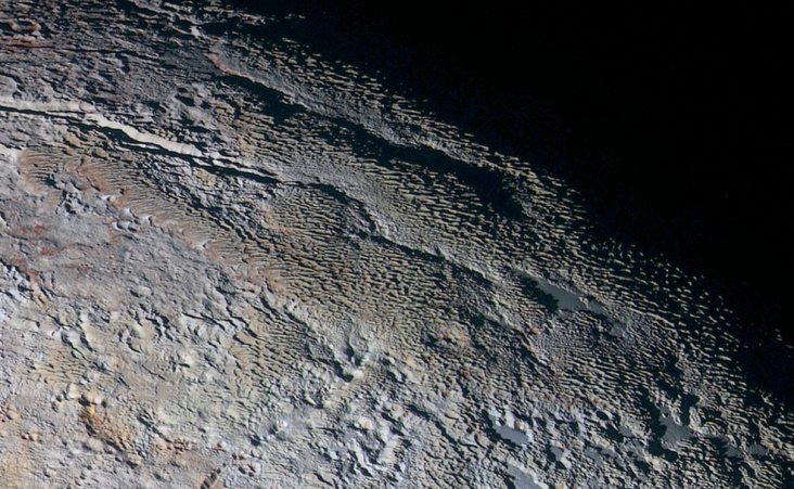
In this extended color image of Pluto taken by NASA’s New Horizons spacecraft, rounded and bizarrely textured mountains, informally named the Tartarus Dorsa, rise up along Pluto’s day-night terminator and show intricate but puzzling patterns of blue-gray ridges and reddish material in between. This view, roughly 330 miles (530 kilometers) across, combines blue, red and infrared images taken by the Ralph/Multispectral Visual Imaging Camera (MVIC) on July 14, 2015, and resolves details and colors on scales as small as 0.8 miles (1.3 kilometers).
Credits: NASA/JHUAPL/SWRI
The new “extended color” view of Pluto – taken by New Horizons’ wide-angle Ralph/Multispectral Visual Imaging Camera (MVIC) on July 14 and downlinked to Earth on Sept. 19 – shows the extraordinarily rich color palette of Pluto.
“We used MVIC’s infrared channel to extend our spectral view of Pluto,” said John Spencer, a GGI deputy lead from Southwest Research Institute (SwRI) in Boulder, Colorado. “Pluto’s surface colors were enhanced in this view to reveal subtle details in a rainbow of pale blues, yellows, oranges, and deep reds. Many landforms have their own distinct colors, telling a wonderfully complex geological and climatological story that we have only just begun to decode.”

This cylindrical projection map of Pluto, in enhanced, extended color, is the most detailed color map of Pluto ever made. It uses recently returned color imagery from the New Horizons Ralph camera, which is draped onto a base map of images from the NASA’s spacecraft’s Long Range Reconnaissance Imager (LORRI). The map can be zoomed in to reveal exquisite detail with high scientific value. Color variations have been enhanced to bring out subtle differences. Colors used in this map are the blue, red, and near-infrared filter channels of the Ralph instrument.
Credits: NASA/JHUAPL/SWRI
Additionally, a high-resolution swath across Pluto taken by New Horizons’ narrow-angle Long Range Reconnaissance Imager (LORRI) on July 14, and downlinked on Sept. 20, homes in on details of Pluto’s geology. These images -- the highest-resolution yet available of Pluto -- reveal features that resemble dunes, the older shoreline of a shrinking glacial ice lake, and fractured, angular water ice mountains with sheer cliffs. Color details have been added using MVIC’s global map shown above.

High-resolution images of Pluto taken by NASA’s New Horizons spacecraft just before closest approach on July 14, 2015, reveal features as small as 270 yards (250 meters) across, from craters to faulted mountain blocks, to the textured surface of the vast basin informally called Sputnik Planum. Enhanced color has been added from the global color image. This image is about 330 miles (530 kilometers) across. For optimal viewing, zoom in on the image on a larger screen.
Credits: NASA/JHUAPL/SWRI
This closer look at the smooth, bright surface of the informally named Sputnik Planum shows that it is actually pockmarked by dense patterns of pits, low ridges and scalloped terrain. Dunes of bright volatile ice particles are a possible explanation, mission scientists say, but the ices of Sputnik may be especially susceptible to sublimation and formation of such corrugated ground.

High-resolution images of Pluto taken by NASA’s New Horizons spacecraft just before closest approach on July 14, 2015, are the sharpest images to date of Pluto’s varied terrain—revealing details down to scales of 270 meters. In this 75-mile (120-kilometer) section of the taken from the larger, high-resolution mosaic above, the textured surface of the plain surrounds two isolated ice mountains.
Credits: NASA/JHUAPL/SWRI
Beyond the new images, new compositional information comes from a just-obtained map of methane ice across part of Pluto's surface that reveals striking contrasts: Sputnik Planum has abundant methane, while the region informally named Cthulhu Regio shows none, aside from a few isolated ridges and crater rims. Mountains along the west flank of Sputnik lack methane as well.
The distribution of methane across the surface is anything but simple, with higher concentrations on bright plains and crater rims, but usually none in the centers of craters or darker regions. Outside of Sputnik Planum, methane ice appears to favor brighter areas, but scientists aren’t sure if that’s because methane is more likely to condense there or that its condensation brightens those regions.
“It's like the classic chicken-or-egg problem,” said Will Grundy, New Horizons surface composition team lead from Lowell Observatory in Flagstaff, Arizona. “We’re unsure why this is so, but the cool thing is that New Horizons has the ability to make exquisite compositional maps across the surface of Pluto, and that’ll be crucial to resolving how enigmatic Pluto works.”
“With these just-downlinked images and maps, we’ve turned a new page in the study of Pluto beginning to reveal the planet at high resolution in both color and composition,” added New Horizons Principal Investigator Alan Stern, of SwRI. “I wish Pluto’s discoverer Clyde Tombaugh had lived to see this day.”
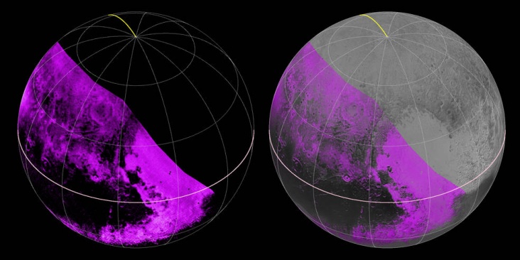
The Ralph/LEISA infrared spectrometer on NASA’s New Horizons spacecraft mapped compositions across Pluto’s surface as it flew by on July 14. On the left, a map of methane ice abundance shows striking regional differences, with stronger methane absorption indicated by the brighter purple colors here, and lower abundances shown in black. Data have only been received so far for the left half of Pluto’s disk. At right, the methane map is merged with higher-resolution images from the spacecraft’s Long Range Reconnaissance Imager (LORRI).
Credits: NASA/JHUAPL/SWRI
Bron: NASA | Gewijzigd: 26 september 2015, 19:11 uur, door Justin
Pluto’s Big Moon Charon Reveals a Colorful and Violent History
NASA’s New Horizons spacecraft has returned the best color and the highest resolution images yet of Pluto’s largest moon, Charon – and these pictures show a surprisingly complex and violent history.
Charon in Enhanced Color NASA's New Horizons captured this high-resolution enhanced color view of Charon just before closest approach on July 14, 2015. The image combines blue, red and infrared images taken by the spacecraft’s Ralph/Multispectral Visual Imaging Camera (MVIC); the colors are processed to best highlight the variation of surface properties across Charon. Charon’s color palette is not as diverse as Pluto’s; most striking is the reddish north (top) polar region, informally named Mordor Macula. Charon is 754 miles (1,214 kilometers) across; this image resolves details as small as 1.8 miles (2.9 kilometers).
Credits: NASA/JHUAPL/SwRI
At half the diameter of Pluto, Charon is the largest satellite relative to its planet in the solar system. Many New Horizons scientists expected Charon to be a monotonous, crater-battered world; instead, they’re finding a landscape covered with mountains, canyons, landslides, surface-color variations and more.
“We thought the probability of seeing such interesting features on this satellite of a world at the far edge of our solar system was low,” said Ross Beyer, an affiliate of the New Horizons Geology, Geophysics and Imaging (GGI) team from the SETI Institute and NASA Ames Research Center in Mountain View, California, “but I couldn't be more delighted with what we see."

High-resolution images of Charon were taken by the Long Range Reconnaissance Imager on NASA’s New Horizons spacecraft, shortly before closest approach on July 14, 2015, and overlaid with enhanced color from the Ralph/Multispectral Visual Imaging Camera (MVIC). Charon’s cratered uplands at the top are broken by series of canyons, and replaced on the bottom by the rolling plains of the informally named Vulcan Planum. The scene covers Charon’s width of 754 miles (1,214 kilometers) and resolves details as small as 0.5 miles (0.8 kilometers).
Credits: NASA/JHUAPL/SwRI
High-resolution images of the Pluto-facing hemisphere of Charon, taken by New Horizons as the spacecraft sped through the Pluto system on July 14 and transmitted to Earth on Sept. 21, reveal details of a belt of fractures and canyons just north of the moon’s equator. This great canyon system stretches more than 1,000 miles (1,600 kilometers) across the entire face of Charon and likely around onto Charon’s far side. Four times as long as the Grand Canyon, and twice as deep in places, these faults and canyons indicate a titanic geological upheaval in Charon’s past.
“It looks like the entire crust of Charon has been split open,” said John Spencer, deputy lead for GGI at the Southwest Research Institute in Boulder, Colorado. “With respect to its size relative to Charon, this feature is much like the vast Valles Marineris canyon system on Mars.”

This composite of enhanced color images of Pluto (lower right) and Charon (upper left), was taken by NASA’s New Horizons spacecraft as it passed through the Pluto system on July 14, 2015. This image highlights the striking differences between Pluto and Charon. The color and brightness of both Pluto and Charon have been processed identically to allow direct comparison of their surface properties, and to highlight the similarity between Charon’s polar red terrain and Pluto’s equatorial red terrain. Pluto and Charon are shown with approximately correct relative sizes, but their true separation is not to scale. The image combines blue, red and infrared images taken by the spacecraft’s Ralph/Multispectral Visual Imaging Camera (MVIC).
Credits: NASA/JHUAPL/SwRI
The team has also discovered that the plains south of the Charon’s canyon -- informally referred to as Vulcan Planum -- have fewer large craters than the regions to the north, indicating that they are noticeably younger. The smoothness of the plains, as well as their grooves and faint ridges, are clear signs of wide-scale resurfacing.
One possibility for the smooth surface is a kind of cold volcanic activity, called cryovolcanism. “The team is discussing the possibility that an internal water ocean could have frozen long ago, and the resulting volume change could have led to Charon cracking open, allowing water-based lavas to reach the surface at that time,” said Paul Schenk, a New Horizons team member from the Lunar and Planetary Institute in Houston.
Images from NASA's New Horizons spacecraft were used to create this flyover video of Pluto's largest moon, Charon. The “flight” starts with the informally named Mordor (dark) region near Charon’s north pole. The camera then moves south to a vast chasm, descending from 1,100 miles (1,800 kilometers) to just 40 miles (60 kilometers) above the surface to fly through the canyon system. From there it’s a turn to the south to view the plains and "moat mountain," informally named Kubrick Mons, a prominent peak surrounded by a topographic depression. New Horizons Long-Range Reconnaissance Imager (LORRI) photographs showing details at up to 400 meters per pixel were used to create the basemap for this animation. Those images, along with pictures taken from a slightly different vantage point by the spacecraft’s Ralph/ Multispectral Visible Imaging Camera (MVIC), were used to create a preliminary digital terrain (elevation) model. The images and model were combined and super-sampled to create this animation.
Credits: NASA/JHUAPL/SwRI/Stuart Robbins
Even higher-resolution Charon images and composition data are still to come as New Horizons transmits data, stored on its digital recorders, over the next year – and as that happens, “I predict Charon’s story will become even more amazing!” said mission Project Scientist Hal Weaver, of the Johns Hopkins University Applied Physics Laboratory in Laurel, Maryland.
The New Horizons spacecraft is currently 3.1 billion miles (5 billion kilometers) from Earth, with all systems healthy and operating normally.
New Horizons is part of NASA’s New Frontiers Program, managed by the agency’s Marshall Space Flight Center in Huntsville, Alabama. APL designed, built, and operates the New Horizons spacecraft and manages the mission for NASA’s Science Mission Directorate. SwRI leads the science mission, payload operations, and encounter science planning.
Bron: http://www.nasa.gov/feature/pluto-s-big-moon-charon-reveals-a-colorful-and-violent-history
For more information and images, visit www.nasa.gov/newhorizons and http://pluto.jhuapl.edu.
BLUE SKIES ON PLUTO
Earth isn't the only planet with blue skies. Pluto has them, too. The first color images of Pluto's atmosphere were beamed back to Earth by NASA's New Horizons spacecraft just last week, and the sky looks a lot like home:
Photo NASA
New Horizons took the picture just after it sped by Pluto on July 14, 2015. The spacecraft's cameras were looking back at Pluto's nightside as sunlight illuminated the fringe of blue around Pluto's circumference.
"Who would have expected a blue sky in the Kuiper Belt?" says Alan Stern, principal investigator of the New Horizons mission. "It's gorgeous."
Carly Howett of the New Horizons science team explains the phenomenon: "A blue sky often results from scattering of sunlight by very small particles. On Earth, those particles are nitrogen molecules. On Pluto they appear to be soot-like particles we call tholins."
The term "tholin" was coined by Carl Sagan and Bishun Khare to describe organic substances they obtained in Miller-Urey experiments on gas mixtures akin to atmosphere of Saturn's moon Titan. On Pluto, tholins form high in the atmosphere where UV sunlight breaks apart nitrogen and methane molecules. The fragments re-combine to form complex macromolecules. These macromolecules continue to combine and grow until they become "tholins."
Ironically, tholins themselves are not blue. They merely scatter blue light. When tholins fall to the ground they show their true colors: gray or red. At least some of Pluto's patchy red coloring is thought to result from a gentle rain of these particles from the planet's atmosphere.
Bron:http://www.spaceweather.com/ | Gewijzigd: 1 februari 2017, 11:25 uur, door Joyce.s
Pluto’s Puzzling Patterns and Pits

This image was taken by the Long Range Reconnaissance Imager (LORRI) on NASA's New Horizons spacecraft shortly before closest approach to Pluto on July 14, 2015; it resolves details as small as 270 yards (250 meters). The scene shown is about 130 miles (210 kilometers) across. The sun illuminates the scene from the left, and north is to the upper left.
Credits: NASA/JHUAPL/SwRI
It seems that the more we see of Pluto, the more fascinating it gets. With its prominent heart-shaped feature, icy mountains, and “snakeskin” terrain, Pluto has already surprised New Horizons scientists with the variety and complexity of its surface features.
Now this latest image, from the heart of Pluto’s heart feature, show the plains’ enigmatic cellular pattern (at left) as well as unusual clusters of small pits and troughs (from lower left to upper right).
Scientists believe that this area, informally known as Sputnik Planum, is composed of volatile ices such as solid nitrogen. They theorize that the pits and troughs – typically hundreds of meters across and tens of meters deep – are possibly formed by sublimation or evaporation of these ices. However, the reasons for the striking shapes and alignments of these features are a mystery. Adding to the intrigue is that even at this resolution, no impact craters are seen, testifying to the extreme geologic youth of Sputnik Planum.
“Pluto is weird, in a good way,” said Hal Weaver, New Horizons project scientist with Johns Hopkins Applied Physics Laboratory in Laurel, Maryland. “The pits, and the way they’re aligned, provide clues about the ice flow and the exchange of volatiles between the surface and atmosphere, and the science team is working hard to understand what physical processes are at play here.”
Bron:http://www.nasa.gov/nh/pluto-puzzling-patterns-and-pits
Last of Pluto’s Moons – Mysterious Kerberos – Revealed by New Horizons

Kerberos Revealed. This image of Kerberos was created by combining four individual Long Range Reconnaissance Imager (LORRI) pictures taken on July 14, approximately seven hours before New Horizons’ closest approach to Pluto, at a range of 245,600 miles (396,100 km) from Kerberos. The image was deconvolved to recover the highest possible spatial resolution and oversampled by a factor of eight to reduce pixilation effects. Kerberos appears to have a double-lobed shape, approximately 7.4 miles (12 kilometers) across in its long dimension and 2.8 miles (4.5 kilometers) in its shortest dimension.
Credits: NASA/JHUAPL/SwRI
Images of Pluto’s tiny moon Kerberos taken by NASA’s New Horizons spacecraft –and just sent back to Earth this week – complete the family portrait of Pluto’s moons.
Kerberos appears to be smaller than scientists expected and has a highly-reflective surface, counter to predictions prior to the Pluto flyby in July. “Once again, the Pluto system has surprised us,” said New Horizons Project Scientist Hal Weaver, of the Johns Hopkins University Applied Physics Laboratory in Laurel, Maryland.
The new data, downlinked from the New Horizons spacecraft on Oct. 20, show that Kerberos appears to have a double-lobed shape, with the larger lobe approximately 5 miles (8 kilometers) across and the smaller lobe approximately 3 miles (5 kilometers) across. Science team members speculate from its unusual shape that Kerberos could have been formed by the merger of two smaller objects. The reflectivity of Kerberos’ surface is similar to that of Pluto’s other small moons (approximately 50 percent) and strongly suggests Kerberos, like the others, is coated with relatively clean water ice.
Before the New Horizons encounter with Pluto, researchers had used Hubble Space Telescope images to “weigh” Kerberos by measuring its gravitational influence on its neighboring moons. That influence was surprisingly strong, considering how faint Kerberos was. They theorized that Kerberos was relatively large and massive, appearing faint only because its surface was covered in dark material. But the small, bright-surfaced Kerberos--now revealed in these new images--shows that the idea was incorrect, for reasons that are not yet understood.
“Our predictions were nearly spot-on for the other small moons, but not for Kerberos,” said New Horizons co-investigator Mark Showalter, of the SETI Institute in Mountain View, California. The new results are expected to lead to a better understanding of Pluto’s fascinating satellite system.

Family Portrait of Pluto’s Moons: This composite image shows a sliver of Pluto’s large moon, Charon, and all four of Pluto’s small moons, as resolved by the Long Range Reconnaissance Imager (LORRI) on the New Horizons spacecraft. All the moons are displayed with a common intensity stretch and spatial scale (see scale bar). Charon is by far the largest of Pluto’s moons, with a diameter of 751 miles (1,212 kilometers). Nix and Hydra have comparable sizes, approximately 25 miles (40 kilometers) across in their longest dimension above. Kerberos and Styx are much smaller and have comparable sizes, roughly 6-7 miles (10-12 kilometers) across in their longest dimension. All four small moons have highly elongated shapes, a characteristic thought to be typical of small bodies in the Kuiper Belt.
Credits: NASA/JHUAPL/SwRI
Bron:http://www.nasa.gov/feature/last-of-pluto-s-moons-mysterious-kerberos-revealed-by-new-horizons

Bergen op Pluto zijn mogelijk ijsvulkanen
De enorme bergen op dwergplaneet Pluto zijn mogelijk ijsvulkanen. Dat onthult het team achter de Amerikaanse ruimtesonde New Horizons maandag op een bijeenkomst van de Amerikaanse Astronomenvereniging (AAS).De sonde vloog eerder dit jaar langs Pluto en stuurt nog steeds informatie terug naar de aarde. Daaruit bleek dat op de dwergplaneet grote bergen te vinden zijn met laagtes op de top, zoals vulkanen op de aarde en Mars.
New Horizons-wetenschapper Oliver White noemt het bestaan van vulkanen op Pluto "het minst gestoorde idee waar we op konden komen" toen werd gezocht naar een verklaring voor het verschijnsel. De vulkanen op Pluto zouden in plaats van lava bijvoorbeeld bevroren water, stikstof of ammoniak kunnen uitspuwen.
Door: ANP
Bron:http://www.nu.nl/wetenschap/4161776/bergen-pluto-mogelijk-ijsvulkanen.html#nieuwe-beelden-pluto-2 | Gewijzigd: 1 februari 2017, 11:25 uur, door Joyce.s
New Horizons Returns First of the Best Images of Pluto

The Mountainous Shoreline of Sputnik Planum: In this highest-resolution image from NASA’s New Horizons spacecraft, great blocks of Pluto’s water-ice crust appear jammed together in the informally named al-Idrisi mountains. "The mountains bordering Sputnik Planum are absolutely stunning at this resolution," said New Horizons science team member John Spencer of the Southwest Research Institute. "The new details revealed here, particularly the crumpled ridges in the rubbly material surrounding several of the mountains, reinforce our earlier impression that the mountains are huge ice blocks that have been jostled and tumbled and somehow transported to their present locations."
Credits: NASA/JHUAPL/SwRI
NASA’s New Horizons spacecraft has sent back the first in a series of the sharpest views of Pluto it obtained during its July flyby – and the best close-ups of Pluto that humans may see for decades.
Each week the piano-sized New Horizons spacecraft transmits data stored on its digital recorders from its flight through the Pluto system on July 14. These latest pictures are part of a sequence taken near New Horizons’ closest approach to Pluto, with resolutions of about 250-280 feet (77-85 meters) per pixel – revealing features less than half the size of a city block on Pluto’s diverse surface. In these new images, New Horizons captured a wide variety of cratered, mountainous and glacial terrains.
“These close-up images, showing the diversity of terrain on Pluto, demonstrate the power of our robotic planetary explorers to return intriguing data to scientists back here on planet Earth,” said John Grunsfeld, former astronaut and associate administrator for NASA’s Science Mission Directorate. “New Horizons thrilled us during the July flyby with the first close images of Pluto, and as the spacecraft transmits the treasure trove of images in its onboard memory back to us, we continue to be amazed by what we see."
These latest images form a strip 50 miles (80 kilometers) wide on a world 3 billion miles away. The pictures trend from Pluto’s jagged horizon about 500 miles (800 kilometers) northwest of the informally named Sputnik Planum, across the al-Idrisi mountains, over the shoreline of Sputnik, and across its icy plains. (To view the strip in the highest resolution possible, click here and zoom in.)
“These new images give us a breathtaking, super-high resolution window into Pluto’s geology,” said New Horizons Principal Investigator Alan Stern, of the Southwest Research Institute (SwRI) in Boulder, Colorado. “Nothing of this quality was available for Venus or Mars until decades after their first flybys; yet at Pluto we’re there already – down among the craters, mountains and ice fields – less than five months after flyby! The science we can do with these images is simply unbelievable."
This movie is composed of the sharpest views of Pluto that NASA’s New Horizons spacecraft obtained during its flyby on July 14, 2015. The pictures are part of a sequence taken near New Horizons’ closest approach to Pluto, with resolutions of about 250-280 feet (77-85 meters) per pixel – revealing features smaller than half a city block on Pluto’s diverse surface. The images include a wide variety of cratered, mountainous and glacial terrains – giving scientists and the public alike a super-high resolution view of Pluto’s complexity.
Credits: NASA/JHUAPL/SwRI

Layered Craters and Icy Plains: This highest-resolution image from NASA’s New Horizons spacecraft reveals new details of Pluto’s rugged, icy cratered plains, including layering in the interior walls of many craters. "Impact craters are nature's drill rigs, and the new, highest-resolution pictures of the bigger craters seem to show that Pluto's icy crust, at least in places, is distinctly layered,” said William McKinnon, deputy lead of the New Horizons Geology, Geophysics and Imaging team, from Washington University in St. Louis. "Looking into Pluto’s depths is looking back into geologic time, which will help us piece together Pluto's geological history.”
Credits: NASA/JHUAPL/SwRI

Pluto’s ‘Badlands’: This highest-resolution image from NASA’s New Horizons spacecraft shows how erosion and faulting have sculpted this portion of Pluto’s icy crust into rugged badlands topography.
Credits: NASA/JHUAPL/SwRI
The images above were captured with the telescopic Long Range Reconnaissance Imager (LORRI) aboard New Horizons, about 15 minutes before New Horizons’ closest approach to Pluto – from a range of just 10,000 miles (17,000 kilometers). They were obtained with an unusual observing mode; instead of working in the usual “point and shoot,” LORRI snapped pictures every three seconds while the Ralph/Multispectral Visual Imaging Camera (MVIC) aboard New Horizons was scanning the surface. This mode requires unusually short exposures to avoid blurring the images.
These new images are six times better than the resolution of the global Pluto map New Horizons obtained, and five times better than the best images of Pluto’s cousin Triton, Neptune’s large moon, obtained by Voyager 2 in 1989.
Mission scientists expect more imagery from this set over the next several days, showing even more terrain at this highest resolution.
Bron:http://www.nasa.gov/feature/new-horizons-returns-first-of-the-best-images-of-pluto
Pluto's Blue Atmosphere in the Infrared

This image from NASA’s New Horizons spacecraft is the first look at Pluto’s atmosphere in infrared wavelengths, and the first image of the atmosphere made with data from the New Horizons Ralph/Linear Etalon Imaging Spectral Array (LEISA) instrument.
In this image, sunlight is coming from above and behind Pluto. The image was captured on July 14, 2015, while New Horizons was about 112,000 miles (180,000 kilometers) away. The image covers LEISA’s full spectral range (1.25 to 2.5 microns), which is divided into thirds, with the shortest third being put into the blue channel, middle third into the green channel, and longest into the red channel. North in this image is around the 10 o’clock position.
The blue ring around Pluto is caused by sunlight scattering from haze particles common in Pluto's atmosphere; scientists believe the haze is a photochemical smog resulting from the action of sunlight on methane and other molecules, producing a complex mixture of hydrocarbons such as acetylene and ethylene. These hydrocarbons accumulate into small particles – a fraction of a micrometer in size – which scatter sunlight to make the blue haze. The new infrared image, when combined with earlier images made at shorter, visible wavelengths, gives scientists new clues into the size distribution of the particles.
The whitish patches around Pluto’s limb in this image are sunlight bouncing off more reflective or smoother areas on Pluto's surface – with the largest patch being the western section of the informally named Cthulhu Regio. Future LEISA observations returned to Earth should capture the remainder of the haze, missing from the lower section of the image.
Credits: NASA/JHUAPL/SwRI
Bron: http://www.nasa.gov/image-feature/plutos-blue-atmosphere-in-the-infrared
'Drijvende' ijsbergen waargenomen op Pluto
Op Pluto zijn ijsbergen te vinden rond de evenaar, zo blijkt uit nieuwe beelden van de dwergplaneet.Het gaat om bergen van bevroren water die vermoedelijk enkele kilometers hoog zijn.
De ijsbergen lijken te drijven op een ondergrond van stikstofijs, meldt de Amerikaanse ruimtevaartorganisatie NASA.
De ijsbergen zijn ontdekt met behulp van beelden en gegevens die zijn verzameld door de ruimtesonde New Horizons, die in 2015 vlak langs Pluto scheerde. De bergen liggen in de buurt van de evenaar van de dwergplaneet op een hartvormige ijsvlakte die bekend staat als Sputnik Planum.
De grote ijsmassa's lijken te bewegen op de beelden. Dat komt waarschijnlijk omdat de bergen zijn ontstaan op stikstofijs.
Aangezien de dichtheid van waterijs minder groot is dan van stikstofijs, drijven de ijsbergen als het ware op het stikstof, zo meldt nieuwssite Science Now. De bergen deinen daardoor soms op en neer.
Gebergte
Sterrenkundigen vermoeden dat de ijsbergen door geologische processen uiteindelijk van de stikstofgletjer naar een grote vlakte op Pluto zullen glijden.
Daar zullen de ijsmassa's waarschijnlijk uitgroeien tot veel grotere gebergtes met een hoogte van tientallen kilometers.Door: NU.nl/Dennis Rijnvis
Bron:http://www.nu.nl/wetenschap/4210288/drijvende-ijsbergen-waargenomen-pluto.html | Gewijzigd: 1 februari 2017, 11:26 uur, door Joyce.s