Typhoon Nepartak is aangegroeid tot een typhoon van categorie 5
Storm en wind
Strengthening Nepartak ends record tropical cyclone drought in western North Pacific
A record was set in the tropical northwestern Pacific Ocean as the basin entered its longest stretch of time without a named tropical cyclone.
The new record of 199 days ended on Sunday with the development of Tropical Storm Nepartak. The lack of tropical systems occurred from Dec. 17, 2015, to July 2, 2016.
The previous record was 198 days which occurred from Dec. 15, 1972, to June 30, 1973, and also from Dec. 22, 1997, to July 7, 1998.

Strengthening Tropical Storm Nepartak will track to the northwest through the coming week, likely strengthening into a typhoon by Tuesday or Wednesday.
Residents of Taiwan, eastern China, South Korea and Japan, including the Ryukyu Islands, are being put on alert for impacts from the tropical system during the latter part of the week.
Flooding rainfall will accompany Nepartak along its path. The risk of damaging winds and rough surf will heighten as it strengthens.
While the worst of the storm is expected to pass to the north of Taiwan, cities in northern parts of the country should remain alert for impacts. This includes Taipei and Keelung.
In the Ryukyu Islands, the Yaeyama and Miyako Islands will have the highest chance for significant impacts from high wind and flooding rainfall. Farther to the north in Okinawa, squally showers and thunderstorms are most likely.
Once in the East China Sea late this week, Nepartak is expected to curve to the north and northeast, potentially bringing impacts to South Korea and the southern mainland of Japan over the weekend. While weakening is expected during this time, Nepartak could still be a typhoon or strong tropical storm.
Nepartak is not expected to be followed by a flurry of tropical activity.
"The window for development looks to slam shut by the upcoming weekend," AccuWeather Senior Meteorologist Jason Nicholls said. "Then, I do not see much opportunity [for further development] until late July."
The current five longest stretches, including this year, without a named tropical system in the western Pacific Basin all occurred during transitions from El Niño to La Niña phase of El Niño-Southern Oscillation (ENSO).
El Niño is defined by above-average sea-surface temperatures in the eastern and central equatorial Pacific Ocean. These sea-surface temperatures cycle from warm to cool, relative to average, over a several-year period.

When the sea-surface temperatures in the same area of the Pacific Ocean are lower than average for a few months, a La Niña pattern has developed.
These below-normal sea-surface temperatures can have significant impacts on tropical development in the western Pacific Ocean.
AccuWeather.com meteorologists are currently predicting a below-normal season for the western Pacific basin with 19 tropical storms and 10 typhoons. This is significantly below the historical averages for the basin.
"This will be one of the least active years on record," AccuWeather Tropical Expert Meteorologist Dan Kottlowski. "The record [for least tropical activity in the western Pacific Ocean] is 14 tropical storms and nine typhoons in 2010."
Areas predicted to have the greatest threat from tropical cyclones over the remainder of this summer include the Philippines, Taiwan and China. This threat is likely to shift toward Japan later in the season.
Despite a well below-normal forecast for tropical cyclones in the western Pacific Ocean, people should not let their guard down as a single strike from a powerful cyclone can cause great destruction and loss of life.
Content contributed to this story by Senior Meteorologist Kristina Pydynowski.
Bron: http://www.accuweather.com/en/weather-news/strengthening-nepartak-ends-re/58557415
Ben47
Lid
Woonplaats: Heenvliet, Eiland Voorne-Putten (Zuid-Holland)
Berichten: 4219
Lid sinds: 16 jan. 2011
Belangrijk gegeven is toch wel een nieuw record ononderbroken duur zonder tropical cyclone. Sinds 15 december 2015 is er tot 2 juli geen sprake van een tropical cyclone.geweest en is daarmee het record van 1972 en 1997 met 1 dag gebroken.
Ook het aantal te verwachten tropische stormen e.d. is zeer laag.
Dit ondanks dat de vele warmisten het alleen maar hebben over toenames van cyclonen.
| Gewijzigd: 5 juli 2016, 14:53 uur, door Ben47
Ook het aantal te verwachten tropische stormen e.d. is zeer laag.
Dit ondanks dat de vele warmisten het alleen maar hebben over toenames van cyclonen.
| Gewijzigd: 5 juli 2016, 14:53 uur, door Ben47
Noem mij de naam van de instantie die opdracht geeft tot een onderzoek van het klimaat en ik geef u per ommegaande het verwachte resultaat van het onderzoek.
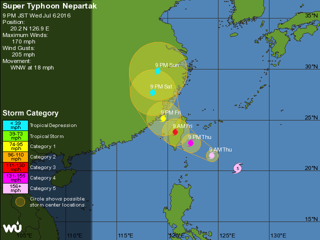
Super Typhoon Nepartak Rapidly Intensifies to Category 5; Potentially Dangerous Threat to Parts of East Asia
Super Typhoon Nepartak has rapidly intensified just under 300 miles southeast of Taipei, Taiwan, and poses a dangerous threat to Taiwan, Japan's far southwest Ryukyu Islands and eastern China late this week.
Nepartak exploded from a tropical storm on July 4 to a Category 5 equivalent super typhoon the following day.

Nepartak developed over the weekend south of Guam and strengthened into a typhoon Monday evening, and was the first named storm in the western north Pacific basin since Dec. 17, 2015, setting a new record for the longest stretch without at least a single tropical storm in the western North Pacific basin in 66 years of records (more on that below).
Nepartak further intensified into a super typhoon on Tuesday afternoon.
Forecast: Typhoon Threat For East Asia
Super Typhoon Nepartak is forecast to move west-northwest and then northwest around the periphery of subtropical high pressure that is in place over the western Pacific.
Exactly when and how sharp Nepartak turns toward the northwest will ultimately determine the impacts in Taiwan, Japan's far southwest Ryukyu Islands and parts of eastern China later this week.
As of this time, it's too soon to tell which of these areas would take a direct hit from Nepartak's core of most intense winds. However, it's looking more likely that at least some part of Japan's far southwest Ryukyu Islands and/or Taiwan will see significant impacts in the form of strong winds and heavy rainfall.
For now, any impacts in Japan's far southwest Ryukyu Islands and Taiwan would arrive Thursday into Friday (local time), and in eastern China, those impacts could arrive late Friday into Saturday.
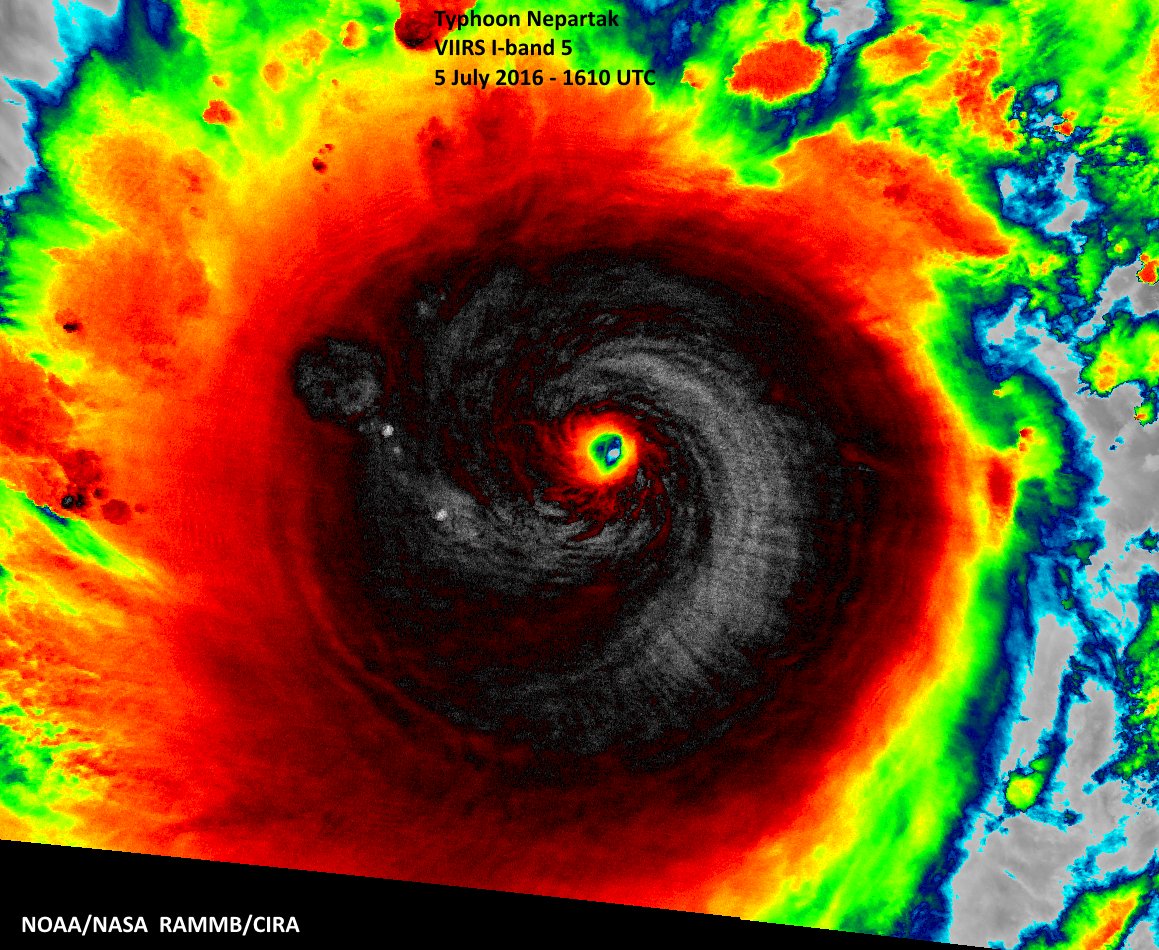
Photo: NOAASatellites
f course, the severity of those impacts will depend on the exact track and strength of Nepartak at that time.
Nepartak is forecast to strengthen further over the next 12 to 18 hours. Short-term, hard-to-predict fluctuations in intensity are common in intense tropical cyclones due to their eyewall being replaced one or more times.
It may weaken a bit before affecting the southwest Ryukus and Taiwan, but still may be an intense tropical cyclone at its nearest pass to those areas. Nepartak is expected to be considerably weaker once it nears China, but how much weaker remains uncertain, for now.

All interests from Taiwan and Japan's Ryukyu Islands to eastern China should monitor the progress of Nepartak closely.
In addition, flooding may be a serious threat along and, potentially, some distance north and east of the path of Nepartak from Taiwan to southwest Japan.
Taiwan endured two landfalls last year, Category 3 equivalent Typhoon Souldelor in early August and Category 4 equivalentTyphoon Dujuan in late September.
Record Long Streak For Western North Pacific Ends
Prior to Nepartak's formation, not a single tropical storm, much less a typhoon (the term for a hurricane in the western North Pacific Basin), had formed west of the international date line since mid-December 2015. Typically this area is the world's busiest tropical cyclone corridor.
This set a new record for the longest stretch without at least a single tropical storm in the western North Pacific basin in 66 years of records, according to Colorado State University tropical scientist Dr. Phil Klotzbach.
Longest Northwest Pacific Stretches Without a Single Tropical Storm
(Source: Joint Typhoon Warning Center archive)
Start, End Dates Consecutive Days
Dec. 17, 2015 - July 3, 2016 200
Dec. 15, 1972 - June 30, 1973 198
Dec. 22, 1997 - July 7, 1998 198
This first six months of 2016 have been completely opposite from what we saw last year.
By the end of June 2015, there had already been nine tropical cyclones in the northwest Pacific basin, including three super typhoons of Category 5 equivalent intensity.
Klotzbach also said Nepartak was the second latest first named northwest Pacific storm of the season on record, behind the record-late July 8, 1998's Tropical Storm Nichole.
Bron:https://weather.com/storms/typhoon/news/tropical-storm-typhoon-nepartak-pacific-east-asia
Het oog van Nepartak:

Volgens de verwachtingen gaat Nepartak recht over Taiwan, daarna koerst de tyfoon naar China, maar voor het daar aankomt is de tyfoon snel afgezwakt van een categorie 5 naar een categorie 1 tyfoon. Wel levert de tyfoon daar nog veel neerslag op, bovenop de overstromingen die ze daar nu al hebben.
https://www.wunderground.com/hurricane/western-pacific/2016/Super-Typhoon-Nepartak?
http://www.weerplaza.nl/weerinhetnieuws/supertyfoon-nepartak-heeft-taiwan-in-het-vizier/2600
https://www.windyty.com/?22.269,124.662,7
Eerder W. in t Erland (Winterland)

Ondertussen bereiken de eerste intense regenbanden van Nepartak(Taiwan).
https://twitter.com/iCyclone/status/751114412430241792?lang=nl
https://twitter.com/iCyclone/status/751114412430241792?lang=nl
there can be only one

Schade door tyfoon op Taiwan valt mee
TAIPEI - De tyfoon Nepartak heeft vrijdag op Taiwan voor relatief weinig schade gezorgd. Het aantal slachtoffers viel eveneens mee. De autoriteiten telden een dode en 66 gewonden nadat de storm was uitgeraasd.Ruim 15.000 mensen werden geëvacueerd. In grote delen van de eilandstaat viel de stroom uit. Bijna 190.000 huishoudens kwamen zonder elektriciteit te zitten. Vooral kleine, goedkopere huizen werden getroffen en verloren hun dak. In het oosten ging de tyfoon gepaard met zware regens waardoor lokaal overstromingen ontstonden. De luchtvaart raakte voor een groot deel verlamd. Meer dan vijfhonderd inkomende en uitgaande vluchten werden geschrapt.
Nepartak trekt inmiddels richting het Chinese vasteland. Volgens meteorologen neemt hij iets in kracht af. China heeft al enkele dagen te lijden onder het slechte weer. Tyfoons zijn normaal in deze tijd van het jaar op en rond de Zuid-Chinese Zee. Vroeger vielen in China talloze doden door de zware stormen. Tegenwoordig evacueert de overheid veel sneller bewoners van bedreigde streken.
Bron: http://www.telegraaf.nl/buitenland/26170119/__Schade_tyfoon_Taiwan_valt_mee__.html | Gewijzigd: 30 januari 2017, 15:10 uur, door Joyce.s