Berichtgeving uitbarsting op Reykjanes, IJsland 2023-2024
Natuurverschijnselen
Uitbarsting ten einde? Het lijkt er wel op...
... maar het is nog te vroeg om het officiëel te bevestigen. De aardbevingen wijzen erop dat het gebied terug aan het stabiliseren is, echter zijn er nog wel 200 kleine aarbevingen geweest die wijzen dat er nog wel magma aan het stromen is onder de grond. Magma stroomt waarschijnlijk richting Grindavík, en de scheuren in de grond daar zijn recent nog groter geworden. Daardoor is er een grote kans dat de uitbarsting hervat wordt, of er binnenkort een nieuwe start.Update 16 January at 11:45 UTC
There is currently no visible activity within the eruptive fissures, with the most recent lava observed emanating from the northern fissure shortly after 1 am last night. Seismic activity continues to decrease, signifying that the area is stabilizing. Approximately 200 small earthquakes were recorded near the magma conduit since midnight, indicating that magma is still migrating. Most seismic activity is located near Hagafell, close to the first eruptive fissure that opened on Sunday morning. At this point, it is premature to declare that the eruption is over.
GPS sensors continue to detect ground deformation in and around Grindavík, illustrating that the magma conduit beneath Grindavík is still causing expansion in the area. Thermal images from a drone last night show that fissures previously mapped southwest of Grindavík have significantly enlarged. Considerable hazards persist in the area.
Vulkaan kan ieder moment weer uitbarsten
Update vedur.is 27. February at 13:00 UTCDe magmakamer onde Svartsengi vult zich sinds de vorige uitbarsting weer met magma. Zodra die magmakamer vol zit, stroomt de magma weer richting Grindavík en is een uitbarsting daar weer mogelijk. De meest waarschijnlijke locatie is nog steeds iets ten noorden van het dorpje.
De IJslandse weer- en vulkanologische dienst verwacht een uitbarsting de komende dagen, omdat de hoeveelheid magma in de magmakamer dezelfde hoeveelheid bereikt als vlak voor vorige uitbarstingen. Zo'n uitbarsting kan plotseling en zonder voorwaarschuwing plaatsvinden. Er blijft echter ook altijd de mogelijkheid dat de magma ondergronds gaat stollen (een zogenoemde "dijk-intrusie), zonder tot uitbarsting te komen.
Modelberekeningen laten zien dat er 7,6 miljoen m3 magma aanwezig is in de magmakamer. Bij vorige uitbarstingen zat er 8 tot 13 miljoen m3 magma in de kamer voordat een drempelwaarde overschreden werd en de vulkaan uitbarstte. Als magma op dezelfde snelheid de magmakamer blijft vullen, kan de vulkaan ieder moment uitbarsten.
Verdere informatie
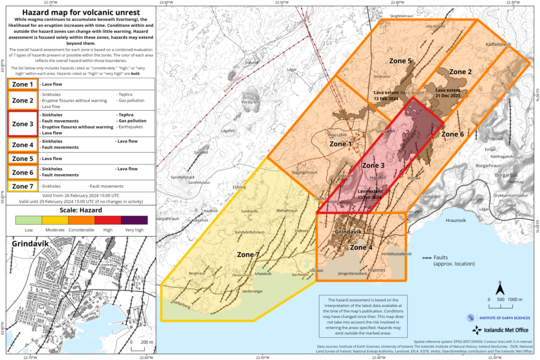
Seismic activity has increased slightly since past weekend and has been most prominent just east of Mt. Sýlingarfell. The location of the seismic activity is in an area which is considered to be the eastern tip of the magma reservoir which is centered beneath the Svartsengi-Þórbjörn area. The current seismicity is similar to that observed days before previous volcanic eruptions in the area.
Therefore, IMO has updated the hazard assessment for the unrest area. Increased likelihood of a volcanic eruption and related hazards affects the assessment. Hazard levels have been raised in several zones. Even though the color of Zone 4 – Grindavík - remains unchanged, the hazards there have increased due to the possibility of lava flows. Same goes for Zone 1 – Svartsengi.
No significant deformation within Grindavík has been detected by GNSS or satellite data. It is however likely that new faults will be revealed when snow melts or precipitation causes soil, which might be covering faults, to be washed away.
If an eruption occurs, scientists estimate that magma will most likely propagate from the reservoir beneath the Svartsengi-Þórbjörn region towards Sundhnúkur crater row, resulting in lava fountaining and lava flows in the area between Stóra-Skógfell and Hagafell. The primary signal of ascending magma is a sudden increase in seismic activity with many localized, small magnitude earthquakes. Considering the previous volcanic eruptions in the area, an eruption could start with very little warning (less than 30 minutes), depending on where magma reaches the surface on the Sundhnúkur crater row.
Likely scenarios
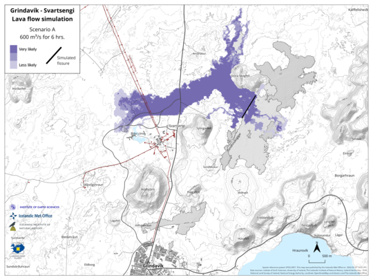
- Eruption between Sýlingarfell and Stóra-Skógfell - As occurred on December 18, 2023 and February 8, 2024.
- Precursor: Sudden, localized, and intense seismic activity with small magnitude earthquakes. Deformation over the magma dike (if a dike is intruded) and the Svartsengi magma reservoir
- Very short warning time (less than 30 minutes) because a new dike propagation may not be required for magma to reach the surface.
- Lava reaches Grindavík road in less than 4 hours.
Eruption by Hagafell – As occurred on January 14, 2024. - Precursor: Seismic activity with small magnitude earthquakes on the Sundhnúkur crater row, starting near Sýlingarfell and migrating south. Deformation over the magma dike and the Svartsengi magma reservoir
- Likely warning time is approximately 1-3 hours from the detection of the first earthquakes until the start of an eruption.
- Lava reaches the lava barriers around Grindavík within 1 hour.
- Magma intrusion, which reaches south of Hagafell, will likely cause significant fault movements in Grindavík
Eruption inside of the lava barriers around Grindavík - Seismic activity with small magnitude earthquakes on the Sundhnúkur crater row, starting near Sýlingarfell and migrating south.
- Deformation over the magma dike and the Svartsengi magma reservoir
- Probable warning time is between approximately 1-5 hours from the detection of the first earthquakes until the start of an eruption.
- It is possible that an eruptive fissure/s will open within Grindavík or the region just north of here (inside the barriers). Similar activity occurred on the 14th of January when a volcanic fissure opened just inside the outer perimeter of the town approximately 4 hours after an onset of the eruption near Hagafell.
- Magma intrusion, which reaches south of Grindavík, will cause significant fault movements in Grindavík.
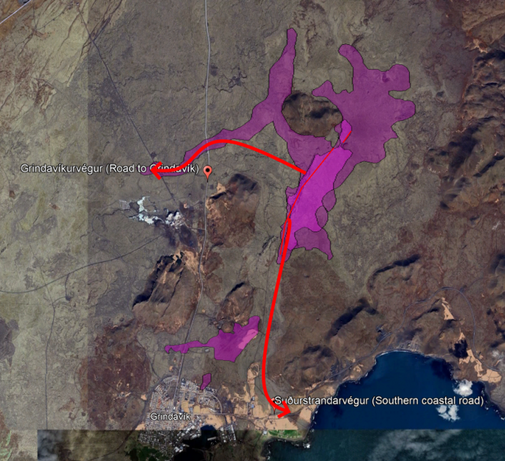
In scenario A, een relatief noordelijke uitbarsting, stroomt de lava opnieuw over de verbindingsweg naar Keflavík (naar het noorden). Deze weg is al buiten gebruik omdat er eerder ook al lava overheen stroomde. Verder kan de lava ook opnieuw de warmwatertoevoer naar het noorden verwoesten. Dit zou voor Reykjanesbaer en Keflavik grote gevolgen hebben.
Met de aanname dat de bescherming van de energiecentrale Svartsengi het houdt, blijft die energiecentrale veilig.
Scenario B heeft een uitbarsting in het centrum van het dorp Grindavík.
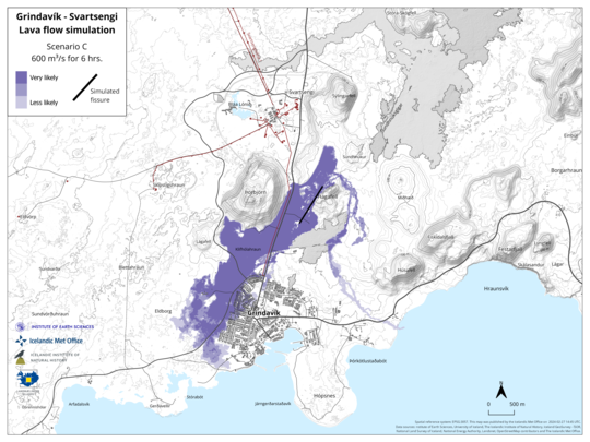
Scenario C laat de lava ook richting Grindavík stromen, vooral de westelijke helft van het dorp is dan erg kwetsbaar voor de verwoestende gevolgen van eventuele lavastromen.
Magma ondergronds tot stilstand gekomen, maar tweede poging op komst
Een uitbarsting heeft afgelopen weekend niet plaatsgevonden. Dit kwam doordat niet de gehele magmakamer van Svartsengi leegliep, slechts een klein gedeelte stroomde weg in de richting van de Grindavík-spleet. De magmakamer is daardoor nog voor een groot deel gevuld. Het zal daardoor slechts uren tot dagen duren voordat de magmakamer weer helemaal vol zit, en de magma daardoor richting de Grindavík-spleet zal gaan stromen.Geologyhub verwacht een nieuwe uitbarsting tussen 5 en 9 maart.Update Icelandic Met Office
March 5 at 11:20 am
Probable sequence of events for the next few days:
The volume of magma under Svartsengi continues to increase, which could end up with a new magma flow and even an eruption
An eruption could start at very short notice, even less than 30 minutes
An eruption is most likely to occur in the area between Stóra-Skógfell and Hagafell
Seismic activity over the magma tunnel has been at its lowest since the magma run ended on Saturday. Rather, there is more activity at Fagradalsfjall, where about 20 earthquakes have been recorded in the last 24 hours.
Model calculations show that about 1.3 million cubic meters passed from the magma chamber under Svartsengi into the magma tunnel on Saturday, March 2. The magma tunnel that formed as a result was about 3 km long and reached from Stóra-Scógfell to Hagafell. The volume of magma that entered the magma tunnel in this event was therefore much smaller than in previous events where about 10 million cubic meters of magma formed the magma tunnel.
Continued landfall is being measured by GPS monitors after the magma intrusion on Saturday. Magma flow under Svartsengi therefore continues, and model calculations show that around half a million cubic meters of magma accumulates in a 24-hour period. In total, about 9.5 million cubic meters of magma have accumulated in the magma chamber under Svartsengi since the eruption on February 8.
Pressure in the magma chamber continues to build, and there is an increased chance of a new magma flow into the Sundhnúks crater series and even an eruption in the coming days.
4de uitbarsting binnen 3 maanden tijd een feit
Nadat tussen 1210 en 1240 de "Reykjanes vuren" voor talloze vulkaanuitbarstingen zorgden op circa dezelfde plek als nu, bleef het 800 jaar stil. De 800 jaar durende periode zonder uitbarstingen werd in maart 2021 doorbroken door de eerste uitbarsting van Fagradalsfjall. Daarna volgden in 2022 de 2de Fagradalsfjall-uitbarsting en in 2023 de derde. Hierna verschoof onze aandacht naar een nabij gelegen vulkanisch systeem, Svartsengi. Afgelopen zaterdagavond begon daar de 4de uitbarsting die de omgeving van Grindavík plaagt. Dat brengt het totaal aantal uitbarstingen sinds 2021 op 7 (3 door Fagradalsfjall en 4 door Svartsengi).Wat houvast wat betreft plaatsnamen op dit stukje IJsland:
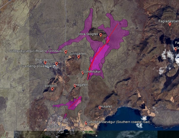
In het oosten ligt Fagradalsfjall (2021-2023 uitbarstingen). Hierboven zie je de met lava bedekte gebieden in het roze (exclusief huidige uitbarsting) en de plaatsnamen. In het rood zie je de spleten waar de lava telkens uit kwam.
fell = berg
végur = weg
De magma heeft zich enige tijd op kunnen bouwen, dus er zat deze keer behoorlijk wat druk achter vanuit de magmakamer. Hierdoor was er bij de uitbarsting in de nacht naar zondag sprake van een lavafontein van circa 275 meter hoog. Sindsdien is de uitbarsting al weer snel in intensiteit afgenomen. Er wordt verwacht dat de uitbarsting in totaal circa 72 uur gaat duren, dus dat wil zeggen dat de uitbarsting ergens dinsdag voorbij is. Morgen zal de uitbarsting verder in intensiteit afnemen.
De omvang van de uitbarsting nam door hoge intensiteit de afgelopen nacht snel toe, maar de lavastromen zullen steeds verder tot stilstand komen. Er zijn 2 dominante lavastromen, eentje naar het westen en een 2de naar het zuiden. De westelijke lavastroom bedreigt opnieuw de warmwatertoevoer naar het grootste vliegveld van IJsland. De zuidelijke lavastroom bedreigt de zuidelijke kustweg. De zuidelijke stroom zou ook de zee kunnen bereiken, maar dat is nog onzeker aangezien ik verwacht dat de lava langzaam tot stilstand komt.
Westelijke lavastroom: nog 200 meter tussen de lavastroom en de warmwatertoevoer (update zondag namiddag)
Zuidelijke lavastroom: nog 350 meter tussen de lavastroom en de zuidelijke kustweg (update zondag namiddag)
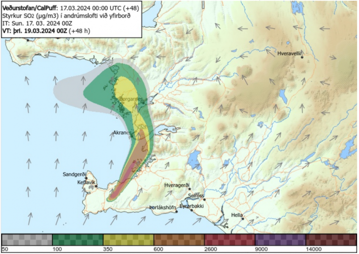
De uitbarsting produceert weinig as, maar wel vulkanische gassen, deze worden door de wind morgenavond tijdelijk richting de hoofdstad Reykjavik geblazen:
Hier kan je voorlopig live meekijken:
Vorm van de spleet
De spleet is een lange lijn met aan zuidelijke zijde een knikje erin. Dat is handig om de beelden te plaatsen en te begrijpen wat noord/west/zuid/oost is.
🌋 A fresh volcanic eruption began in Iceland on Saturday evening with little warning, again threatening previously evacuated areas.
— Weather & Radar UK/Ireland (@WeatherRadar_UK) March 17, 2024
Check out the helicopter shots from the scene below, and read more on the website or app. 👇https://t.co/JJd3TjxKhe#Volcano #Iceland #Eruption pic.twitter.com/aI9tAAg8ZO
Incredible view of the new eruption in #Iceland this evening. Just WOW!!!
— Volcaholic 🌋 (@volcaholic1) March 16, 2024
Via: https://t.co/0UYVQ1Bnf0 pic.twitter.com/nbYq2rAWZJ
Beelden zuidelijke lavastroom
Oh wow! Incredible video of the eruption this evening in #Iceland
— Volcaholic 🌋 (@volcaholic1) March 17, 2024
📹 Kristinn Gauti Gunnarssonpic.twitter.com/9V7AS5xnmA
Lava creeping towards the town of Grindavik right now
— Arnar & Simona (@arnark) March 17, 2024
Photo : Almannavarnir pic.twitter.com/zy5ZxAP2OW
Hier zie je last-minute werkjes aan de lavadijk die Grindavík moet beschermen:
Iceland erupts for the fourth time in 3 months. Biggest eruption of them all, lava estimated to reach the Atlantic Ocean later today if this continues at current speed. Sharing is caring but if you don’t tag me in reposts the lava God will be mad! pic.twitter.com/vAt77ObiwX
— Bjorn Steinbekk (@BSteinbekk) March 17, 2024
En bij daglicht zie je hoe dichtbij de lava is bij de zuidelijke kustweg en de zee.
The lava, captured in a video by Hörður Kristleifsson, is swiftly nearing Suðurstrandarveg. According to an expert from the Icelandic Meteorological Office interviewed nearly an hour ago, approximately 350 meters remain until its arrival, though the lava's speed has decreased… pic.twitter.com/QuUlnuhw1h
— Volcaholic 🌋 (@volcaholic1) March 17, 2024
Beelden westelijke lavastroom
*English subtitles*
— Fréttastofa RÚV (@RUVfrettir) March 17, 2024
Hér má sjá hraunið renna yfir Grindavíkurveg, nánast á sama stað og það gerði í febrúar. pic.twitter.com/XbMSNstniT
In de verte zie je de zuidelijke lavastroom en Grindavík. Iets verder naar voren zie je de lichtjes van de Svartsengi energiecentrale, en de westelijke lavastroom die praktisch dezelfde route volgt (de lavadijk is hier ook effectief). Tip: Geluid uit wegens irritant geluid.
New video showing the extent of the lava flow with the lava flowing towards Grindavik.....#Iceland
— Volcaholic 🌋 (@volcaholic1) March 17, 2024
📹 @h0rdur via: @mblfrettirpic.twitter.com/eIdjqaVseM
Dan krijgen wij zo langzamerhand als Nederland toch wel concurrentie van IJsland wat betreft dijkenbouwers. Lavadijken klinken toch net wat cooler dan onze waterdijkjes
| Gewijzigd: 17 maart, 23:15 uur, door Thijs.
Update IJslandse meteorologische & vulkanologische dienst
17. March at 18:40 UTC
Since 04:00 UTC today, the propagation of lava has slowed substantially. However, the eruption has not ended, and lava continues to be extruded from a 0.5-km-long fissure, as confirmed by web camera and drone imagery. A lava front extends to the west from Sundhnúkur crater row. This front inundated Grindavíkurvegur in the early hours of Sunday morning at around 00:30 UTC, making the road impassable.
Lava also travelled southwards, and it is now less than 250 m from Suðurstrandarvegur – the main road on the southern coast of the Reykjanes Peninsula. Between 10:15 and 16:30 UTC today, this lava front moved at an average speed of 12 m per hour. Assuming the same speed of movement, it will take the front an additional ~20 hours to reach the main road. In the event of the lava reaching the road, an additional 350 m of propagation would be needed before lava could enter the sea.
Potentiële risico's wanneer lava zee bereikt
In the event of lava interacting with seawater, there would be a range of volcanic hazards due to the sudden cooling of lava. Initially, these hazards would comprise localised tephra deposition (solid volcanic particles) and the formation of volcanic gases, principally hydrogen chloride (HCl). Within a radius of 0.5 km from the entry point into the sea, there would be potentially lethal health hazards. With increasing distance, the severity of the volcanic hazards decreases over a radius of 3 km. Beyond that distance, health hazards due to gas pollution would be minor in nature.
Based on the development of the eruption today, our assessment is that lava flow into the sea is an unlikely scenario. However, until the eruption ends, and lava propagation stops entirely, it remains an outcome to consider for hazard assessment purposes. Assuming the same speed of movement (12 m per hour), it would take the southern lava front two days to reach the coastline.
Intensiteit uitbarsting blijft afnemen, relatief grote pluim vulkanisch gas
The latest #eruption in #Iceland has produced the largest #volcanic SO₂ cloud measured to date in the 2023-24 #Reykjanes Fires, consistent with reports that it is the most intense episode so far.
— Prof. Simon Carn (@simoncarn) March 17, 2024
Data: @CopernicusEU #Sentinel5P #TROPOMI. @Vedurstofan @rockhardIES @Alberto_Carac pic.twitter.com/7d14SksJjX
Lava komt langzaam tot stilstand
De vulkanische activiteit is relatief stabiel gebleven sinds zondagavond. De lava kruipt zeer traag dichter naar de zuidelijke kustweg (Suðurstrandarvegur). Het gaat zo traag dat de lava niet bepaald veel dichterbij is gekomen sinds zondagavond. Er ligt nog 330 meter tussen de lava en de weg.De uitbarsting is nu beperkt tot twee punten op de originele spleet, uit de twee meest zuidelijke kraters stroomt de lava richting de zuidelijke kustweg. De westelijke lavastroom richting de weg naar Grindavik (Grindavíkurvegur) is tot stilstand gekomen, dus dat betekent dat de warmwatervoorziening voor Keflavik Airport en omgeving waarschijnlijk veilig zijn.
Het bedekte oppervlak was zondagmiddag 5,85 km2, sindsdien is er niet veel aan oppervlakte bijgekomen. Het oppervlak is berekend met satellietbeelden, dus er zit enige onnauwkeurigheid in. Als het weer het toelaat kunnen er binnenkort per vliegtuig nauwkeurigere berekeningen komen van het oppervlak en volume van de lava.
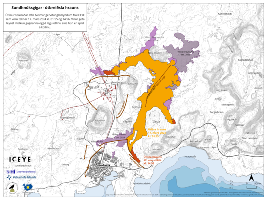
The outlines of the lava flow are drawn from satellite images from Iceye. The first image was taken on March 17 at 01:55 (orange color), which is about five and a half hours after the eruption began. The second image was taken at 14:56 on March 17, showing the outlines of the lava, as it was then, shown in red. Purple colors indicate lava flows from previous eruptions.
| Gewijzigd: 19 maart, 09:25 uur, door Thijs.
Maart 2024 uitbarsting nu grootste en langste van de Reykjanes reeks*
*De Reykjanes reeks (4 uitbarstingen: december 2023, januari 2024, februari 2024 en maart 2024) is een aparte reeks. De Fagradalsfjall uitbarstingen (2021-2023) behoren tot een ander nabijgelegen vulkanisch systeem.De uitbarsting gaat door, zij het wel op een veel lager pitje. Mogelijk is er iets verandert in de magmakamer van Svartsengi. Voorheen vulde de magmakamer zich met magma uit diepte, wat vervolgens allemaal in één keer naar de uitbarstingsspleet stroomt ("magma run event"). Nu deze uitbarsting zo lang duurt, zou het kunnen dat magma vanuit de diepte direct naar de uitbarsting toe stroomt. De fase waarbij het zich verzameld in de magmakamer wordt nu dus misschien overgeslagen.
Eruptive activity stable on fifth day
20.3.2024
The eruptive activity appears to be relatively stable and eruptive vents remain in the same locations as yesterday. Lava flows from the craters towards the south, on top of lava which flowed in the first days of the eruption. Little or no movement has been detected on the lava flow fronts near the South Coast Road and Svartsengi. Seismic activity since the eruption began on Saturday night has been minor.
Gas pollution is thus dispersed to the north-west and could be detected in Reykjanesbær and nearby areas. On 17 March, SO2 gas emission from the eruption was measured up to 50 kg/s, but preliminary results from new measurements indicate that the emission of gas has decreased considerably since then.
An InSAR image published yesterday showed clear signs of land inflation in Svartsengi from 17 to 18 March. GPS data from 18 March suggest that the inflation rate is possibly decreasing. This could be due to magma now flowing towards the surface in the Sundhnúkur crater row and therefore does not accumulate beneath Svartsengi. The development of the eruption and deformation signals over the next few days will reveal whether an equilibrium will be reached between the magma inflow beneath Svartsengi and the lava flow on the surface in the Sundhnúkur crater row.
We've had some questions from English speakers about road construction over lava in Iceland. This is Grindavíkurvegur, the road to the town of Grindavík, the Svartsengi power plant and the Blue Lagoon. Lava has flowed over this road three times. pic.twitter.com/duDXrbVBt1
— Fréttastofa RÚV (@RUVfrettir) March 22, 2024
Lava overstroomt oude mijn
The #eruption on the #Reykjanes Peninsula continues. Yesterday, lava flowed down to a gravel mine, used to provide materials for construction projects. Watch the dramatic video here. pic.twitter.com/TgE9kyioXq
— RÚV English (@RuvEnglish) March 22, 2024
Spatter cone (sintel- of scoriakegel) vormt zich (en stort weer deels in)
Oooo! Nice partial cone collapse just now 😍#Iceland pic.twitter.com/qerkiOpApP
— Volcaholic 🌋 (@volcaholic1) March 22, 2024
Lavastromen worden niet langer, maar wel dikker: gevaar voor lavadijken Grindavík?
Uitbarsting stabiel, lava stroomt langs lavadijk, uitbarsting niet veilig voor toeristen
Vedur.is - update 22 maart
Volcanic activity at the eruption sites near Sundhnúkur remains stable. There is little to no earthquake activity in the dike or its vicinity. Land uplift in the area around Svartsengi has been very slight since the dike intrusion and subsequent eruption began on March 16. This suggests that less magma is accumulating beneath Svartsengi and is instead flowing more directly out of the reservoir through the eruptive fissures. However, there may be indications that uplift has increased in Svartsengi since then, but it cannot be confirmed at this point. Measurements in the coming days will shed more light on this development.
https://en.vedur.is/about-imo/news/volcanic-unrest-grindavik
Zwavelgas bereikt Europa, van Ierland tot Noordwest-Rusland
Bij de vulkaanuitbarsting in IJsland komt ook het gas zwaveldioxide vrij. Deze uitbarsting is anders dan de gebruikelijke uitbarstingen die we elders in de wereld zien. Wereldwijd spreken we vaak over explosieve uitbarstingen waarbij verbrijzelde stenen (as) en vulkanische gassen kilometers hoog de lucht in geslingerd worden. Die aspluim, welke op enkele kilometers hoogte door de atmosfeer beweegt, kan gevaarlijk zijn voor vliegtuigen. Een recent voorbeeld daarvan is de Eyjafjallajökull-uitbarsting in 2010, waarbij het vliegverkeer in Europa een tijdje stil lag.De huidige reeks van uitbarstingen in IJsland zijn echter spleetuitbarstingen ("fissure eruptions"). Hierbij komt vrijwel geen as vrij, en de vulkanische gassen worden niet kilometers hoog de lucht ingeslingerd. In plaats daarvan stroomt er nu een relatief kleine hoeveelheid zwaveldioxide in de onderste laag van de atmosfeer. Omdat zwaveldioxide een hogere dichtheid heeft (het is 'zwaarder') kan het zich wel snel over het zeeoppervlak verspreiden. Zwaveldioxide is giftig in hoge concentraties, die concentraties zien we echter alleen in een straal van 10 km rond de vulkaan, verder wordt nergens een giftige concentratie behaald. De concentraties zwaveldioxide zijn te laag om een tijdelijke vulkanische afkoeling te bewerkstelligen. Met menselijke klimaatverandering heeft dit ook niets te maken, zonder invloed van de mens zijn vulkaanuitbarstingen en het klimaat in evenwicht. Grote uitbarstingen kunnen dat evenwicht slechts op korte tijdschalen verstoren (circa max 10 jaar), op lange termijn herstelt het evenwicht zich weer. Ik wilde dit toch even benadrukken, want veel mensen zijn zich niet helemaal bewust van de verschillende tijdschalen en orde van grootte.
Met de zuidenwinden op het programma zal er voorlopig geen SO2 richting ons komen, ik verwacht sowieso dat de vulkaan langzaam steeds minder gas gaat uitstoten.🌋🇮🇸 #CopernicusAtmosphere forecasts of SO2 from #volcanic eruptions in Iceland's #Reykjanes Peninsula have been showing transport across Ireland, the UK and Scandinavia over the last few days.
— Copernicus ECMWF (@CopernicusECMWF) March 21, 2024
Read more about our monitoring at https://t.co/9JalDSdIU8 pic.twitter.com/U6mWMoHgIF
The sulphur dioxide plume emitted by the large eruption in Iceland’s Reykjanes peninsula has reached Ireland and the United Kingdom and is moving towards Scandinavia. According to the Copernicus Atmosphere Monitoring Service (CAMS) global system, the plume is being transported over the Greenland and the Barents Seas and over Ireland and the United Kingdom. The latest CAMS forecast predicts the main plume to travel across Scandinavia and the Baltic states towards northwest Russia.
https://atmosphere.copernicus.eu/icelands-volcanic-eruption-emissions-reach-uk-and-ireland
Vergelijking met Laki
Ik las wel eens over de Laki uitbarsting van 1783, dat was een enorme uitbarsting in IJsland. Toen verspreidde zwaveldioxide zich in hoge concentraties tot Groot-Brittannië, Noorwegen, Tsjechië en Parijs. Er vielen zelfs 23.000 doden in Groot-Brittannië door zwavelvergiftiging [bron, bron]. Ik kon me dat slecht voorstellen dat een uitbarsting in IJsland voor zoveel giftig gas in onze omgeving zou kunnen zorgen. Nu zie ik echter dat het kleine uitbarstinkje al kan zorgen voor een zwavelpluim tot Noordwest-Rusland, dan zou een grote uitbarsting inderdaad wel voor enorm veel zwaveldioxide kunnen zorgen. Zeker als zwaveldioxide zich met hoge dichtheid als een deken over oceanen en zeeën verspreid.
122.000 kiloton,
Reykjanes uitbarsting 2024: 10 kiloton SO2, tot 4 km hoogte
| Laki 1783-84 | 122.000 kiloton (122 miljoen kg) | Tot ongeveer 14 km hoogte |
| Reykjanes 2024 | 10 kiloton (10 duizend kg) | Tot 4 km hoogte |
The summer of 1783 was the hottest on record and a rare high-pressure zone over Iceland caused the winds to blow to the south-east.[13] The poisonous cloud drifted to Bergen in Denmark–Norway, then spread to Prague in the Kingdom of Bohemia (now the Czech Republic) by 17 June, Berlin by 18 June, Paris by 20 June, Le Havre by 22 June, and Great Britain by 23 June. The fog was so thick that ships stayed in port, unable to navigate, and the sun was described as "blood coloured".[13]
Inhaling sulfur dioxide gas causes victims to choke as their internal soft tissues swell – the gas reacts with the moisture in the lungs and produces sulfurous acid.[21] The local death rate in Chartres was up by 5% during August and September, with more than 40 dead. In Great Britain, the east of England was most affected. The records show that the additional deaths were among outdoor workers; the death rate in Bedfordshire, Lincolnshire, and the east coast was perhaps two or three times the normal rate. It has been estimated that 23,000 British people died from the poisoning.[22]
https://en.wikipedia.org/wiki/Laki