

http://www.noodweer.be/wp-content/uploads/2012/05/onweerskaartje-14-mei-2012.jpgw
auw ziet er goed uit voor hier
auw ziet er goed uit voor hier
Als je een ander veroordeeld zegt dat niets over de ander, maar alles over jou.
Citaat van svenne, maandag 14 mei 2012, 20:04 uur Frank Deboosere: zelfs een vlok smeltende sneeuw op de Hoge Venen is niet uigesloten..
Moeten we terug een winterdiscussietoppic opstarten? :p
Hij waarschuwt voor heel zware buien!
Inderdaad, de kansen op natte sneeuw zitten er duidelijk in.")
Staat op verschillende kaarten die ik heb bekeken.
Moeten we terug een winterdiscussietoppic opstarten? :p
Hij waarschuwt voor heel zware buien!
Inderdaad, de kansen op natte sneeuw zitten er duidelijk in.
Staat op verschillende kaarten die ik heb bekeken.
Onweersdagen met hagel: 2 ---- Licht onweer: 7
Onweersdagen met rukwinden: 4 ---- Matig onweer: 1
Onweersdagen in totaal 2015: 9 ---- Zwaar onweer: 1
Onweersdagen met rukwinden: 4 ---- Matig onweer: 1
Onweersdagen in totaal 2015: 9 ---- Zwaar onweer: 1
Buffell
Lid
Woonplaats: Gendringen (za-zo) Nijmegen (zo.avond - vrijdag)
Berichten: 1325
Lid sinds: 25 mei. 2009
Citaat van thunderstorms_4ever, maandag 14 mei 2012, 22:29 uur Citaat van svenne, maandag 14 mei 2012, 20:04 uur Frank Deboosere: zelfs een vlok smeltende sneeuw op de Hoge Venen is niet uigesloten..
Moeten we terug een winterdiscussietoppic opstarten? :p
Hij waarschuwt voor heel zware buien!
Inderdaad, de kansen op natte sneeuw zitten er duidelijk in.
Staat op verschillende kaarten die ik heb bekeken.
Mei'se grillen dus :p
Moeten we terug een winterdiscussietoppic opstarten? :p
Hij waarschuwt voor heel zware buien!
Inderdaad, de kansen op natte sneeuw zitten er duidelijk in.
Staat op verschillende kaarten die ik heb bekeken.
Mei'se grillen dus :p

Bart Standaert
Lid
Woonplaats: Koekelare, West-Vlaanderen https://twitter.com/BartStandaert
Berichten: 2744
Lid sinds: 15 jun. 2007
Hier ook gehoord. Hieronder de Estofex-kaart voor vandaag.
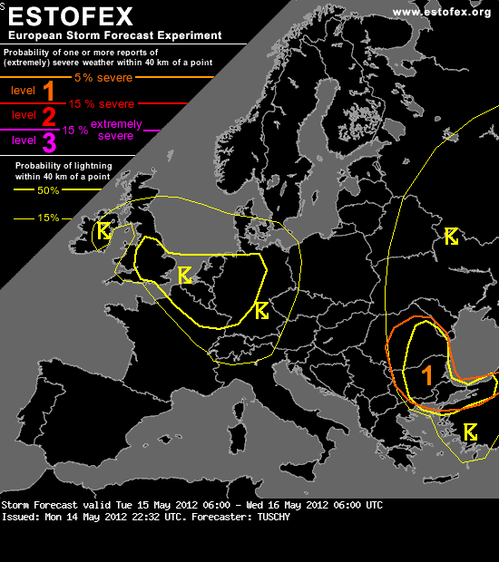
...Ireland, UK, Benelux, NE-France and Germany ...
A well structured upper trough enters the highlighted area from the NW with 500 hPa temperature dropping to less than -30 °C atop marginal BL moisture. Hence, a strong diurnal convection cycle is expected with weak shear and SBCAPE up to 500 J/kg. Marginal hail and strong wind gusts accompany stronger storms with peak activity over Benelux, UK and far W-Germany. Would not be surprised to receive an isolated tornado report in the 50-% thunderstorm area with augmented LL CAPE build-up and weak background shear.
Another focus for some severe will be the eastward sliding cold front, which intensifies over C-Germany due to some prefrontal heating. Placed beneath a 15 m/s mid level jet, shear is sufficiently enhanced for an isolated better organized multicell event over C/E-Germany. Isolated large hail and strong wind gusts accompany those storms. The activity is too limited in strength and coverage for a level 1. Thunderstorms gradually decay after sunset.
Bron: http://www.estofex.org/
BartS
Bart Standaert
Lid
Woonplaats: Koekelare, West-Vlaanderen https://twitter.com/BartStandaert
Berichten: 2744
Lid sinds: 15 jun. 2007

Citaat van MarkNL, dinsdag 15 mei 2012, 6:57 uur Zojuist wakker geworden van een flinke onweersknal. Buitje was pas vlak daarvoor ontstaan en het is ook bij die ene knal gebleven.
Hier het zelfde, alleen was die hagelbui al genoeg om mij bijna rechtovereind in bed te krijgen
Hier het zelfde, alleen was die hagelbui al genoeg om mij bijna rechtovereind in bed te krijgen

En ooh voor de tweede (eigenlijk derde keer) vandaag! De volgende bui regio brugge is ook een aangename! Ferme flitsers en nog hardere knallen weer! Wel geen hagel in deze bui.
Alé, ik mag niet klagen vandaag dat dat allemaal boven m'n huis passeert
Alé, ik mag niet klagen vandaag dat dat allemaal boven m'n huis passeert