Berichtgeving over de cycloon Ellie in Australie
Storm en wind
Cyclone develops off far north coast
A cyclone has developed off the far north Queensland coast near Cairns. The weather bureau's Gavin Holcombe says Tropical Cyclone Ellie is a small Category 1 system. He says it is likely to make landfall tomorrow morning. If it does cross the coast it will be between Cairns and Ayr and most likely area around Cardwell area, he said.
As it gets nearer the coast and crosses the coast if it does so, it will certainly bring rain, especially (to the) Herbert Burdekin coast. But he says it will not develop into a big system. Basically over the next 12 to 18 hours I expect we will see a slight intensification but it'll still stay a Category 1, he said.
©abc
Ellie likely to make landfall Monday
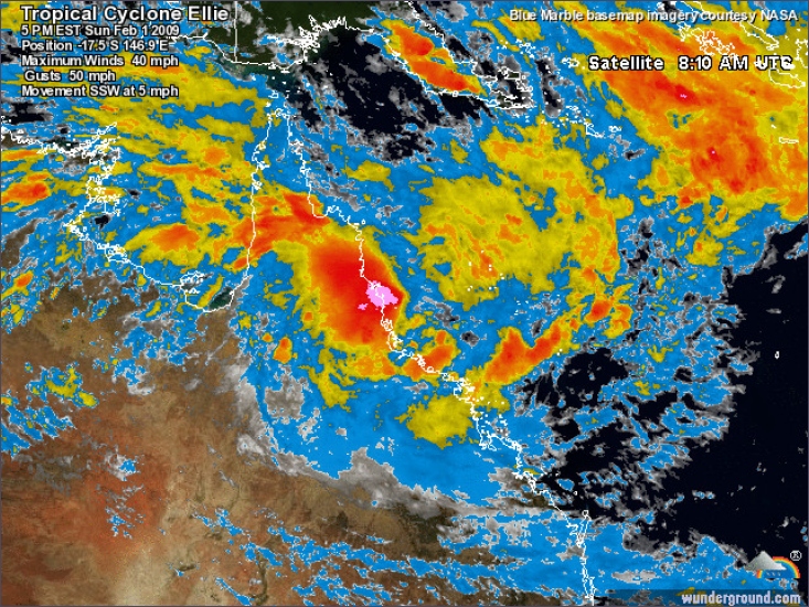
Far north Queensland is expected to start feeling the impact of Tropical Cyclone Ellie this afternoon. It developed overnight and is now a small Category 1 system which is sitting about 165 kilometres east of Cairns. Gavin Holcombe from the Cyclone Warning Centre says Ellie is likely to make landfall tomorrow. It will intensify a little bit overnight tonight but ... the chance of it moving into a Category 2 aren't real high, he said.
Also once it nears the coast, whether it keeps moving inland or whether it hovers around the coast and moves in the other direction is still uncertain at this stage. Cairns regional mayor Val Schier says residents should clean up their yards and have their cyclone kits ready. In case the power should go off, they have radio and batteries and food that doesn't need refrigeration, she said.
But it's only a Category 1 so we're not expecting there'll be huge damage. David Grant from the Cyclone Warning Centre says it should make landfall at Hinchbrook Island before crossing the coast south of Cardwell. It's around 9:00am [AEST] tomorrow morning when we're expecting it currently, he said. We're pretty confident on the track because we do have steering from the loft in the middle bringing that system towards the south-west and I'm fairly confident that direction the system is moving in currently.
A cyclone watch centre has been set up in Tully as a category one system hovers off the Far North Queensland coast. Cassowary Coast mayor Bill Shannon says people should be prepared. So it's probably nothing terribly major but people should do the fundamental things such as remove any object likely to become flying missiles during the cyclone, and prepare by taping windows and the like, he said.
"But there's no cause for anything more dramatic than that at this stage."
©abc
Flooding fears as north Qld dumped with rain
Major flooding is expected in north Queensland as ex-tropical cyclone Ellie dumps heavy rain across the region. The category one storm crossed the coast near Mission Beach between Cairns and Townsville at midnight AEST. The cyclone quickly lost its gale force winds and has been downgraded, with the major threat now flooding. There is a severe weather warning from Innisfail to Mackay. Emergency crews are continuing to monitor river levels and are urging people to stay away from floodwaters. Innisfail has recorded more than 300 millimetres of rain and Ingham is preparing for the possibility of major flooding later today.
Floodwaters have cut the Bruce Highway south of Innisfail and also at Rollingstone, north of Townsville. At Mission Beach this morning there is little sign that a tropical cyclone crossed has coast. The rain and wind has eased considerably and people are out walking along the picturesque waterfront. Ellie only brought down a few trees, with even the fragile banana trees standing up to its winds. Long-time resident Brian says he was concerned around midnight when the winds started to pick up.
"Water was starting to come into the louvres a wee bit but it seemed to reach a certain peak and just dissipated," he said.
The only thing out of the ordinary is that you could almost surf in the normally placid waters off Mission Beach. Another resident, Bryce, says the winds did pick up enough to make him bring in the furniture off his verandah but it dissipated soon afterwards.
"We've been for a bit of a walk this morning and there's a few leaves and branches down here and there but nothing major," he said. Emergency Management Queensland says it received no calls for assistance in the area since Ellie struck the coast. The weather bureau is warning of flooding in coastal rivers from Townsville to Mackay.
Hinchinbrook Mayor Pino Giandominico is urging residents to consider sand bagging immediately.
I advise people to start preparing for the worst I mean it's better to be prepared," he said. If it doesn't reach the major levels at least you're prepared. Weather bureau spokesman Brian Rolstone says Ellie will reform later this week. An upper level trough will capture it, bring it out over the ocean and it'll start to spin up and probably be back into cyclone force by Thursday, he said.
Dick Camilleri from Tully Sugar in the state's far north says the cyclone caused about $3 million worth of damage to the region's cane fields. In the whole the inundation of some of the lower-lying areas, the amount of rain we had, cloud cover we had, I think it would be fair to say that Tully's probably lost about 100,000 tonnes growth, he said.
Community Cabinet
The Queensland Government has cancelled meetings that were to be held at Ayr, south of Townsville today as part of a Community Cabinet meeting. A spokesman for Premier Anna Bligh says people who have already made deputations will be contacted by the relevant Minister or department head. Meanwhile, the Queensland Government says individual graziers affected by flooding in the state's north-west may be entitled to new government assistance.
Primary Industries Minister Tim Mulherin has activated the joint State and Federal Government scheme. Mr Mulherin says it is the biggest flood event in the region in 15 years and many graziers have lost stock and face hefty repair bills.
He says property owners can apply for Individual Disaster-stricken Property Declaration and Assistance. But he says despite the devastation the rain is welcomed. Mayors are reporting that whilst there's minimal stock losses, the overall effects of this rain following the heart-breaking drought is more than welcome, Mr Mulherin said. This rain will be millions and millions of dollars in increased production for graziers and for fishing in the Gulf.
Bron:ABCNews
North Qld braces for more flooding
The north Queensland town of Ingham is bracing for the worst flooding in 10 years, with the Herbert River expected to peak tomorrow. Cyclone Ellie has left its mark on the region despite being downgraded to a rain depression. Ex-tropical cyclone Ellie crossed the coast at Mission Beach last night and is moving inland from Cardwell, dumping heavy rain in north Queensland river catchments. In Ingham, emergency authorities expect the Herbert River to rise above 12 metres, causing major flooding.
Hinchinbrook Mayor Pino Giandominico expects the river to peak tomorrow. Probably looking at a high percentage of the Ingham district will have water in their yards and under their houses, he said. The Burdekin Shire Council is also preparing for major flooding. Mayor Lyn McLaughlin expects the town of Giru will be isolated by floodwaters tonight. The SES are doorknocking up in Giru to alert all the residents again, he said.
More rain
The weather bureau is forecasting more heavy falls tonight. Forecaster David Grant says the system will continue to move west, but has the potential to reform later in the week over the Coral Sea. He says a severe weather warning remains in place between Cardwell and Bowen.
In the 24 hours to 9am the low did drop rainfall totals as high as 377 millimetres at Fisher Creek, just out the back of Innisfail and generally in the area just south of Cairns to north of Townsville the falls 150 to 200 millimetres there in just 24 hours, he said. The damage from ex tropical cyclone Ellie is being assessed with road repairs expected to run into the millions.
There are no reports of any structural damage from the category one system that crossed the coast at Mission Beach around midnight. Queensland Treasurer Andrew Fraser is in Townsville today for Community Cabinet and says the cost of this year's wet season is starting to mount. We've seen significant rainfall across the whole of the state now disaster declared, he said.
"It is a huge challenge to meet those costs. We have our other challenges at the moment from the fallout from the global financial crisis and of course this just adds to the burden."
©abc | Gewijzigd: 30 januari 2017, 09:23 uur, door Joyce.s
Floodwaters swamp north Qld
There has been no let-up in north Queensland with floodwaters continuing to rise and homes being evacuated in the aftermath of ex-tropical cyclone Ellie. Almost 420 millimetres of rain has fallen at Ingham in the past two days, isolating the community. Heavy falls continue with the weather bureau forecasting more rain.
The Herbert River through Ingham peaked overnight with more than a dozen homes now flooded and another 400 with water underneath them. The State Emergency Service (SES) will use boats to access the worst affected areas this morning to check on residents. Queensland Emergency Services Minister Neil Roberts says it is the third highest flood in Ingham's history.
The Herbert River peaked at around 3am at 12.2 metres, he said. In practical terms that meant around 200 homes had external inundation and unfortunately around 10 homes had one to two metres go right through them, so it's been quite devastating for those families. Hinchinbrook Mayor Pino Giandominico says the scale of the flood has caught newcomers by surprise.
The floods we have been having were only baby floods, so when we get a good one people are going to get a shock because a lot of people around the district, especially newcomers, thought they were in a flood-free area, he said. Councillor Giandominico says there have been some evacuations of elderly residents.
We have asked people to move out before the event but as always you get people who want to stay, he said. Weather bureau hydrologist Jeff Perkins says water levels will stay high for most of the day. The Herbert flood river levels have basically peaked at major flood level and they've remained steady since midnight and they'll remain high during today and fall tonight and into tomorrow, he said.
District disaster coordinator Superintendent Noel Powers says the emergency response has been professional. The biggest problem is just going to be monitoring where the roads are going to be shut and responding to any calls for assistance, he said.More...
©abc | Gewijzigd: 30 januari 2017, 09:23 uur, door Joyce.s
Krokodillen hebben vrij spel in noorden Australië
De autoriteiten in de Australische deelstaat Queensland hebben burgers gewaarschuwd voor grote krokodillen en slangen. De gevaarlijke dieren zijn al gezien in diverse steden en dorpen, die zijn getroffen door overstromingen. Dat meldden media in Australië woensdag.
Queensland is ongeveer drie keer zo groot als Frankrijk en ligt in het noordoosten van Australië. Sinds december wordt het gebied getroffen door noodweer. Zeker zeventien rivieren zijn buiten hun oevers getreden. Duizenden huizen staan onder water of raakten beschadigd. Mijnen moesten worden gesloten vanwege het wassende water en twee derde van de deelstaat is inmiddels tot rampgebied verklaard.
De hulp aan burgers in de getroffen regio wordt gehinderd door de aanwezigheid van krokodillen en slangen. Zo werden in de plaats Normanton drie grote krokodillen gezien. Donna Smith, een hotelmanager in deze plaats, meldde de BBC dat een vier meter lange krokodil in de hoofdstraat van het stadje inwoners en honden de schrik van hun leven bezorgde.
©AD | Gewijzigd: 30 januari 2017, 09:24 uur, door Joyce.s

Vermisten na overstromingen noorden Australië
Grote delen van de deelstaat Queensland in het noordoosten van Australië staan onder water na een week van zware regenval. De autoriteiten lieten zondag weten dat twee mensen worden vermist, nadat ze met hun auto door het water waren meegesleurd.
Verder wordt sinds zondagmorgen een 7-jarige jongen vermist. De politie liet weten dat de jongen mogelijk door een krokodil is gedood. De broer van het vermiste kind had gezegd dat de jongen zijn hond in een overstroomd gebied was gevolgd. Niet ver van de plek waar de jongen het water in ging, zag diens broer een krokodil.
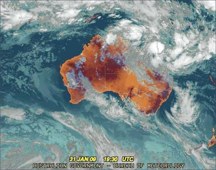
De autoriteiten van de deelstaat hebben een groot gedeelte van Queensland tot rampgebied verklaard. In een gebied van meer dan 1 miljoen vierkante kilometer is overlast door de overstromingen. Het zuiden van Australië kampt juist met droogte. De temperaturen liepen in de afgelopen dagen op tot boven de 40 graden. Zeker 84 mensen zijn in het zuiden door bosbranden om het leven gekomen.
bron: ad
Grote delen van de deelstaat Queensland in het noordoosten van Australië staan onder water na een week van zware regenval. De autoriteiten lieten zondag weten dat twee mensen worden vermist, nadat ze met hun auto door het water waren meegesleurd.
Verder wordt sinds zondagmorgen een 7-jarige jongen vermist. De politie liet weten dat de jongen mogelijk door een krokodil is gedood. De broer van het vermiste kind had gezegd dat de jongen zijn hond in een overstroomd gebied was gevolgd. Niet ver van de plek waar de jongen het water in ging, zag diens broer een krokodil.
De autoriteiten van de deelstaat hebben een groot gedeelte van Queensland tot rampgebied verklaard. In een gebied van meer dan 1 miljoen vierkante kilometer is overlast door de overstromingen. Het zuiden van Australië kampt juist met droogte. De temperaturen liepen in de afgelopen dagen op tot boven de 40 graden. Zeker 84 mensen zijn in het zuiden door bosbranden om het leven gekomen.
bron: ad
Floodwaters continue to isolate Ingham
Ingham in north Queensland remains cut off by floodwaters despite hopes the Bruce Highway would reopen today. The town has been cut off for the last eight days but flood waters are slowly receding. Police are monitoring the highway, south to Townsville, and are hopeful trucks carrying emergency supplies make it though this afternoon.
When the Bruce Highway opens to all traffic between Ingham and Townsville, police want motorists travelling further north to delay their journey. Sergeant Geoff Bormann says it will take longer for the highway north of Ingham to open and he does not want extra people stranded in the town. At the moment we just don't have the facilities or the food supplies for that to happen, he said. We don't need a heap of people coming up and creating a bottleneck there.
He says motorists should stay in Townsville.
The floodwater is continuing to drop slowly and residents are being warning to watch for the dangers of fast flowing water.
Emergency Management Queensland regional director Jason Cameron says there has also been unconfirmed crocodile sightings in flooded creeks running through the middle of town.
We've had a couple of sightings I believe of crocodiles in the area, he said.
So again residents are reminded and particularly children not to play in those waters and steer clear of them until they recede and cleared by the Council.More...
Bron:abc | Gewijzigd: 30 januari 2017, 09:24 uur, door Joyce.s
Hulpgoederen bereiken overstroomd gebied Australië
De eerste vrachtwagens met hulpgoederen hebben de stad Ingham in het noorden van Australië bereikt. Ingham en nog een paar andere plaatsen in deelstaat Queensland waren de voorbije week afgesloten voor de buitenwereld door overstromingen.
Volgens de Australische nieuwszender ABC is het water de afgelopen dagen wel gedaald en is een belangrijke weg in Queensland opnieuw geopend. Daardoor kunnen een tiental vrachtwagens onder begeleiding van politie hulpgoederen afleveren in de gebieden die getroffen zijn door de watersnood.
Infecties
Intussen adviseren de gezondheidsautoriteiten om niet zonder schoenen door het water te lopen. "We maken ons zorgen over infecties", aldus een arts in een ziekenhuis van Ingham, "Het water van de overstromingen bevat heel wat bacteriën en dus is in blote voeten erdoor lopen, af te raden."
Terwijl in Queensland grote delen overstroomden door een periode van zware regenval, kampt het zuiden van Australië met grote droogte. Daar hebben bosbranden intussen al minstens 180 levens geëist.
Bron:HLN.Be | Gewijzigd: 30 januari 2017, 09:24 uur, door Joyce.s