
Danny a Threat to Mid-Atlantic, New England
People living along or planning to visit the East Coast this weekend will need to pay close attention to newly formed Tropical Storm Danny. Danny is expected to track near the coast of the mid-Atlantic and New England Friday night into the weekend. Tropical Storm Danny formed late Wednesday morning to the east of the Bahamas, making it the fourth named storm of the 2009 Atlantic Hurricane Season. Danny will track northwestward through Thursday, staying east of the Bahamas.

The storm will then take a turn more toward the north Friday before curving to the northeast over the weekend. This path puts areas from the North Carolina coast to New England at risk. As the storm moves over warmer waters and into weaker wind shear Thursday into Friday, it is expected to strengthen into a hurricane by the early part of the weekend. The forecast path released by the AccuWeather.com Hurricane Center continues to show Danny passing just east of the Outer Banks of North Carolina Friday night before strengthening into a hurricane and making landfall over Long Island or southeastern New England late Saturday or Saturday night. There is still a chance that Danny tracks farther west, moving over the Outer Banks. There is also a chance the storm heads farther to the east like Bill, missing New England and never making landfall along the East Coast. AccuWeather.com meteorologists will continue to get a better idea in the coming days as to where exactly this feature will track, how strong it will become, who will be at risk and what the impacts will be.

Danny's current projected track would bring tropical storm-force winds along and near the coastline of the Outer Banks on north through the Virginia Capes Friday night into early Saturday. It would then make landfall as a Category 1 hurricane in southern New England later Saturday, bringing damaging winds and flooding rain.
Bron: Accuweather
Beelden: NOAA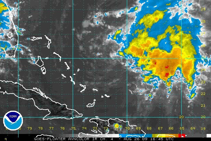 | Gewijzigd: 26 augustus 2009, 19:38 uur, door Marga
People living along or planning to visit the East Coast this weekend will need to pay close attention to newly formed Tropical Storm Danny. Danny is expected to track near the coast of the mid-Atlantic and New England Friday night into the weekend. Tropical Storm Danny formed late Wednesday morning to the east of the Bahamas, making it the fourth named storm of the 2009 Atlantic Hurricane Season. Danny will track northwestward through Thursday, staying east of the Bahamas.
The storm will then take a turn more toward the north Friday before curving to the northeast over the weekend. This path puts areas from the North Carolina coast to New England at risk. As the storm moves over warmer waters and into weaker wind shear Thursday into Friday, it is expected to strengthen into a hurricane by the early part of the weekend. The forecast path released by the AccuWeather.com Hurricane Center continues to show Danny passing just east of the Outer Banks of North Carolina Friday night before strengthening into a hurricane and making landfall over Long Island or southeastern New England late Saturday or Saturday night. There is still a chance that Danny tracks farther west, moving over the Outer Banks. There is also a chance the storm heads farther to the east like Bill, missing New England and never making landfall along the East Coast. AccuWeather.com meteorologists will continue to get a better idea in the coming days as to where exactly this feature will track, how strong it will become, who will be at risk and what the impacts will be.
Danny's current projected track would bring tropical storm-force winds along and near the coastline of the Outer Banks on north through the Virginia Capes Friday night into early Saturday. It would then make landfall as a Category 1 hurricane in southern New England later Saturday, bringing damaging winds and flooding rain.
Bron: Accuweather
Beelden: NOAA
| Gewijzigd: 26 augustus 2009, 19:38 uur, door Marga
Every cloud has a silver lining
Tropical Storm Danny flexes muscles in Atlantic
Tropical Storm Danny strengthened in the Atlantic on Thursday as it moved toward land. Meanwhile, Ignacio was downgraded to a tropical depression far out in the Pacific. Forecasters say people in the Carolinas and northward to New England should monitor Danny's progress.

Danny has maximum sustained winds of 60 mph early Thursday with slow strengthening expected over the next few days. Danny was centered about 575 miles south-southeast of Cape Hatteras, North Carolina, and was moving northwest near 10 mph. In the Pacific, Ignacio weakened to a tropical depression with maximum sustained winds near 35 mph. Ignacio was centered about 1,060 miles west of the southern tip of Mexico's Baja California peninsula.
©MSNBC
Tropical Storm Danny strengthened in the Atlantic on Thursday as it moved toward land. Meanwhile, Ignacio was downgraded to a tropical depression far out in the Pacific. Forecasters say people in the Carolinas and northward to New England should monitor Danny's progress.
Danny has maximum sustained winds of 60 mph early Thursday with slow strengthening expected over the next few days. Danny was centered about 575 miles south-southeast of Cape Hatteras, North Carolina, and was moving northwest near 10 mph. In the Pacific, Ignacio weakened to a tropical depression with maximum sustained winds near 35 mph. Ignacio was centered about 1,060 miles west of the southern tip of Mexico's Baja California peninsula.
©MSNBC
Tropische Storm Danny
Danny is de naam van de vierde Tropische Storm van het jaar 2009. Hier kunt u zijn progressie volgen de komende dagen. De afgelopen dagen kreeg een buiencomplex ten noordoosten van de Bahama's karakteristieken van een tropisch systeem. Toen op 26 augustus ook voldoende windsnelheid werd gemeten was de vierde Tropische Storm van het seizoen een feit en kreeg het systeem de naam Danny.
Danny heeft momenteel een gemiddelde wind van 95 km/u (windkracht 10). Momenteel veroorzaakt Danny hoge golven vooral op de Bahama's. Volgens de laatste verwachtingen zal Danny wat in kracht toe nemen. De kans dat hij binnen 48 uur een orkaan wordt is momenteel ongeveer 50%.

De verwachting is dat Danny vandaag richting het noordwesten zal trekken, maar de komende dagen wat naar het noorden tot noordoosten afbuigt. Dit brengt hem ongeveer op het spoor van Orkaan Bill en voert hem langs de oostkust van de Verenigde Staten richting Nova Scotia (Canada).
Bron: WeerOnline/NHC
Danny is de naam van de vierde Tropische Storm van het jaar 2009. Hier kunt u zijn progressie volgen de komende dagen. De afgelopen dagen kreeg een buiencomplex ten noordoosten van de Bahama's karakteristieken van een tropisch systeem. Toen op 26 augustus ook voldoende windsnelheid werd gemeten was de vierde Tropische Storm van het seizoen een feit en kreeg het systeem de naam Danny.
Danny heeft momenteel een gemiddelde wind van 95 km/u (windkracht 10). Momenteel veroorzaakt Danny hoge golven vooral op de Bahama's. Volgens de laatste verwachtingen zal Danny wat in kracht toe nemen. De kans dat hij binnen 48 uur een orkaan wordt is momenteel ongeveer 50%.
De verwachting is dat Danny vandaag richting het noordwesten zal trekken, maar de komende dagen wat naar het noorden tot noordoosten afbuigt. Dit brengt hem ongeveer op het spoor van Orkaan Bill en voert hem langs de oostkust van de Verenigde Staten richting Nova Scotia (Canada).
Bron: WeerOnline/NHC
North Carolina Under Tropical Storm Watch Ahead of Danny
Forecasters have issued a tropical storm watch for the North Carolina coast ahead of Tropical Storm Danny. Forecasters say large swells are expected to produce dangerous surf and life-threatening rip currents along the U.S. East Coast over the next day or two. The watch is in effect from Cape Lookout north to Duck, including the Pamlico and Albemarle Sounds.
Danny is centered about 485 miles south-southeast of Cape Hatteras, N.C., and moving north at 8 mph. Tropical Storm force winds extend out more than 200 miles. Danny's maximum sustained winds decreased Thursday evening to near 45 mph but strengthening is possible over the next few days.
Bron: Fox news
Every cloud has a silver lining
Weakened Danny Targets East Coast
Forecasters say Tropical Storm Danny has weakened over the Atlantic and is barely a tropical storm. But a tropical storm watch for the North Carolina coast remains in effect Friday morning. Large swells from Danny are expected to produce dangerous surf and life-threatening rip currents along the U.S. East Coast over the next day or two.

Danny's maximum sustained winds have decreased to near 40 mph. The storm is centered about 355 miles south of Cape Hatteras, N.C., and moving north-northwest near 9 mph. A turn to the north with an increase in speed is expected later in the day.
©CBS News
Forecasters say Tropical Storm Danny has weakened over the Atlantic and is barely a tropical storm. But a tropical storm watch for the North Carolina coast remains in effect Friday morning. Large swells from Danny are expected to produce dangerous surf and life-threatening rip currents along the U.S. East Coast over the next day or two.
Danny's maximum sustained winds have decreased to near 40 mph. The storm is centered about 355 miles south of Cape Hatteras, N.C., and moving north-northwest near 9 mph. A turn to the north with an increase in speed is expected later in the day.
©CBS News
East Coast Beaches Pounded Again
As Tropical Storm Danny skirts northward off the East Coast, dangerous surf with large waves and rip currents will once again impact beaches. Rain will also reach coastal areas from the Outer Banks of North Carolina tonight to New England Saturday, making it a rough day at the beach.

While weaker than Bill was when paralleling the Atlantic Seaboard, Danny will move closer to the coast. Rough surf will hit New England especially hard, where the storm will come closest to the coast. Waves in excess of 10 feet could impact the southeastern New England coastline Saturday.
People are urged not to stand near rocky areas along the coastline, as large waves can come crashing in and cause serious injury or even death. It is strongly advised not to go into the water without a lifeguard on duty.
If you are caught in a rip current, don't panic. Swim parallel to the beach until you get out of the narrow rip current. Once out of the current, you should be able to swim back to shore.
©Accuweather
As Tropical Storm Danny skirts northward off the East Coast, dangerous surf with large waves and rip currents will once again impact beaches. Rain will also reach coastal areas from the Outer Banks of North Carolina tonight to New England Saturday, making it a rough day at the beach.
While weaker than Bill was when paralleling the Atlantic Seaboard, Danny will move closer to the coast. Rough surf will hit New England especially hard, where the storm will come closest to the coast. Waves in excess of 10 feet could impact the southeastern New England coastline Saturday.
People are urged not to stand near rocky areas along the coastline, as large waves can come crashing in and cause serious injury or even death. It is strongly advised not to go into the water without a lifeguard on duty.
If you are caught in a rip current, don't panic. Swim parallel to the beach until you get out of the narrow rip current. Once out of the current, you should be able to swim back to shore.
©Accuweather
Danny Stronger, Despite Downgrade
Danny is getting stronger, despite an official downgrade from tropical storm status and is still set to blast coastal New England through this evening with windswept, flooding rain and potential damage. People over coastal New England, Nova Scotia, Newfoundland and southeastern New Brunswick should be prepared for strong tropical storm effects or the risks that come from a strong nor'easter. Tropical Rainstorm Danny will brush the New England coast on a north to northeast path in the western Atlantic through tonight, before slamming in Nova Scotia early Sunday. The most concentrated area of heavy rain will occur over coastal New England and part of the Maritimes, where the greatest risk of flooding exists. From two to four inches of rain will fall.

Wind gusts of 40 to 60 mph will buffet the New England coast (especially on Cape Cod and the islands) into this evening, then diminish later tonight. The gusty winds will shift into the maritime provinces of Canada tonight and Sunday. The combination of soggy ground, gusty winds and crashing down, water-logged trees and limbs can lead to power interruptions. Downpours and flooding will also lead to travel delays.While the wave action is much less with Danny compared to last weekend's Bill, rip currents have already claimed lives. A boy was swept out to sea in the Outer Banks Friday. Minor beach erosion has also been occurring.

Meanwhile, to the west and south of the direct effects from Danny, locally drenching showers and gusty thunderstorms continue to be troublesome. The hit-and-miss rainfall over the eastern Great Lakes and the mid-Atlantic into Saturday night could end up being locally damaging and disruptive.
Bron: Accuweather
Danny is getting stronger, despite an official downgrade from tropical storm status and is still set to blast coastal New England through this evening with windswept, flooding rain and potential damage. People over coastal New England, Nova Scotia, Newfoundland and southeastern New Brunswick should be prepared for strong tropical storm effects or the risks that come from a strong nor'easter. Tropical Rainstorm Danny will brush the New England coast on a north to northeast path in the western Atlantic through tonight, before slamming in Nova Scotia early Sunday. The most concentrated area of heavy rain will occur over coastal New England and part of the Maritimes, where the greatest risk of flooding exists. From two to four inches of rain will fall.
Wind gusts of 40 to 60 mph will buffet the New England coast (especially on Cape Cod and the islands) into this evening, then diminish later tonight. The gusty winds will shift into the maritime provinces of Canada tonight and Sunday. The combination of soggy ground, gusty winds and crashing down, water-logged trees and limbs can lead to power interruptions. Downpours and flooding will also lead to travel delays.While the wave action is much less with Danny compared to last weekend's Bill, rip currents have already claimed lives. A boy was swept out to sea in the Outer Banks Friday. Minor beach erosion has also been occurring.
Meanwhile, to the west and south of the direct effects from Danny, locally drenching showers and gusty thunderstorms continue to be troublesome. The hit-and-miss rainfall over the eastern Great Lakes and the mid-Atlantic into Saturday night could end up being locally damaging and disruptive.
Bron: Accuweather
Every cloud has a silver lining