59 satellietfoto's van de Aarde
Foto en video weer / natuur / wildlife / landschappen
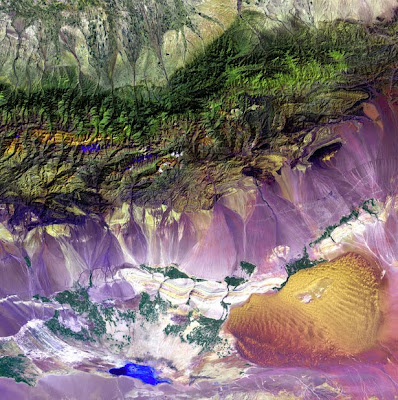
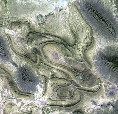
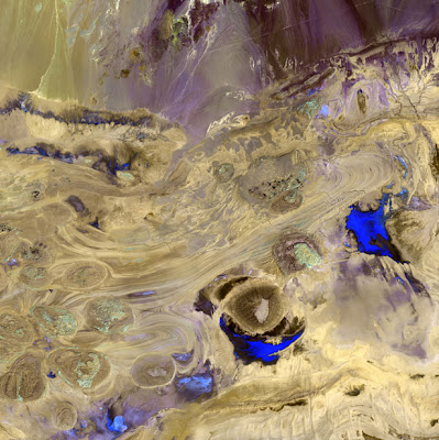
Bogda Mountains - The Turpan Depression, nestled at the foot of China’s Bogda Mountains, is a strange mix of salt lakes and sand dunes, and is one of the few places in the world that lies below sea level.

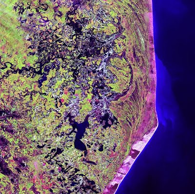
Delta Region, Netherlands - Along the southern coast of the Netherlands, sediment-laden rivers have created a massive delta of islands and waterways in the gaps between coastal dunes. After unusually severe spring tides devastated this region in 1953, the Dutch built an elaborate system of dikes, canals, dams, bridges, and locks to hold back the North sea.
Akpatok Island - Akpatok Island lies in Ungava Bay in northern Quebec, Canada. Accessible only by air, Akpatok Island rises out of the water as sheer cliffs that soar 500 to 800 feet (150 to 243 m) above the sea surface. The island is an important sanctuary for cliff-nesting seabirds. Numerous ice floes around the island attract walrus and whales, making Akpatok a traditional hunting ground for native Inuit people.

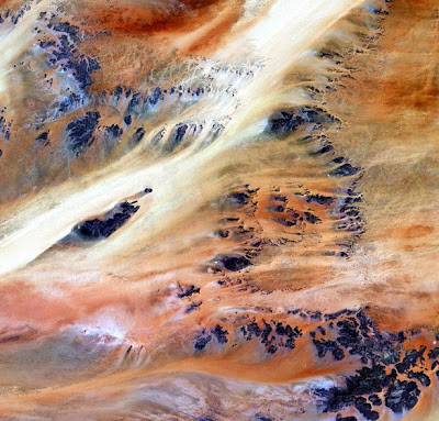
Alluvial Fan, China - A vast alluvial fan blossoms across the desolate landscape between the Kunlun and Altun mountain ranges that form the southern border of the Taklimakan Desert in China’s XinJiang Province.
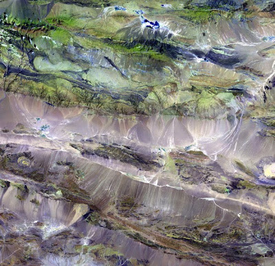
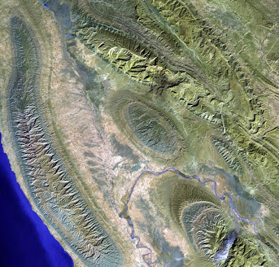
Atlas Mountains - These are the Anti-Atlas Mountains, part of the Atlas Mountain range in southern Morocco, Africa. The region contains some of the world’s largest and most diverse mineral resources, most of which are still untouched.
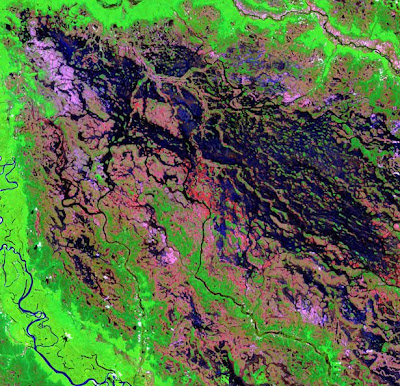
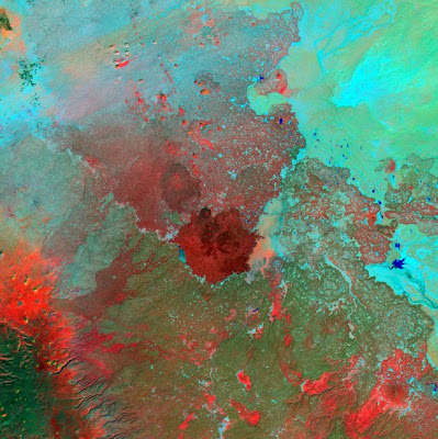
Bolivian Deforestation - Once a vast carpet of healthy vegetation and virgin forest, the Amazon rain forest is changing rapidly. This image of Bolivia shows dramatic deforestation in the Amazon Basin. Loggers have cut long paths into the forest, while ranchers have cleared large blocks for their herds. Fanning out from these clear-cut areas are settlements built in radial arrangements of fields and farms. Healthy vegetation appears bright red in this image.

Brandberg Massif - Rising unexpectedly from the heart of the Namib Desert in northern Namibia, the Brandberg Massif is an exhumed granite intrusion. Unique plant and animal communities thrive in its high-altitude environment, and prehistoric cave paintings decorate walls hidden in its steep cliffs.
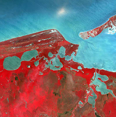
Cabo San Antonio – Several hundred kilometers southeast of Buenos Aires, Cabo San Antonio juts out into the Atlantic Ocean along the Argentinean Coast.
Cancun - Known for its beaches and resort hotels, Cancun lies at the tip of Mexico’s Yucatan Peninsula. Inland from this tourist mecca, however, lies a sparsely populated tropical scrub forest that shelters the ruins of ancient Mayan cities.
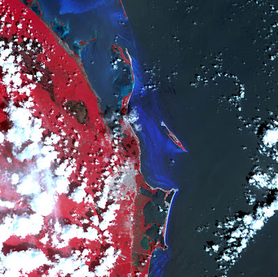
Campeche – Named after the ancient Mayan Province of Kimpech, the state of Campeche comprises much of the western half of Mexico’s Yucatan Peninsula. Rivers in southern Campeche drain into the immense Terminos Lagoon, the entrance to which is protected by a long barrier island, Isla Del Carmen.
Coahuila, Mexico - This desolate landscape is part of the Sierra Madre Oriental mountain range, on the border between the Coahuila and Nuevo Leon provinces of Mexico.
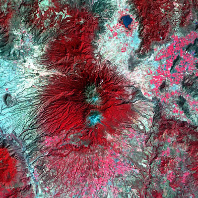
Colima Volcano - Snow-capped Colima Volcano, the most active volcano in Mexico, rises abruptly from the surrounding landscape in the state of Jalisco. Colima is actually a melding of two volcanoes, the older Nevado de Colima to the north and the younger, historically more active Volcan de Colima to the south. Legend has it that gods sit atop the volcano on thrones of fire and ice.
Dasht-e Kevir – The Dasht-e Kevir, or valley of desert, is the largest desert in Iran. It is a primarily uninhabited wasteland, composed of mud and salt marshes covered with crusts of salt that protect the meager moisture from completely evaporating.
Demini River – A marsh-like area borders the Demini River in northwestern Brazil. The Demini eventually joins the Amazon River.
Desolation Canyon – Utah’s Green River flows south across the Tavaputs Plateau (top) before entering Desolation Canyon (center). The Canyon slices through the Roan and book Cliffs – two long, staircase-like escarpments. Nearly as deep as the Grand Canyon, Desolation Canyon is one of the largest unprotected wilderness areas in the American West.
©Uniquescoop
Edrengiyn Nuruu - The Edrengiyn Nuruu forms a transition zone between the Mongolian steppes to the north and the arid deserts of northern China to the south.
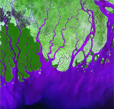
Ganges River Delta - The Ganges River forms an extensive delta where it empties into the Bay of Bengal. The delta is largely covered with a swamp forest known as the Sunderbans, which is home to the Royal Bengal Tiger.

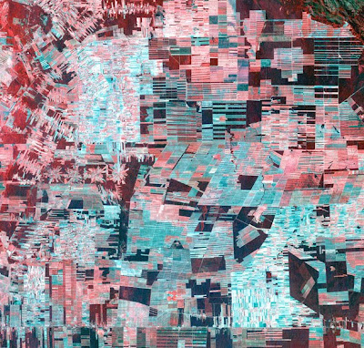
Garden City, Kansas – Center pivot irrigation systems create red circles of healthy vegetation in this image of croplands near Garden City, Kansas.
Ghadamis River - This scar on an arid landscape is the dry riverbed of the Ghadamis River in the Tinrhert Hamada Mountains near Ghadamis, Libya.
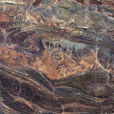
Gosses Bluff – 142 million years ago, an asteroid or comet slammed into what is now the Missionary Plains in Australia’s Northern Territory, forming a crater 24 kilometers in diameter and 5 kilometers deep. Today, like a bull’s eye, the circular ring of hills that defines Gosses Bluff stands as a stark reminder of the event.
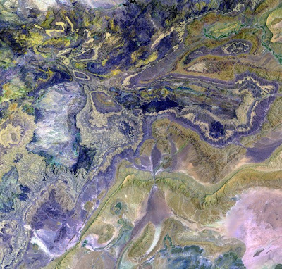
Great Salt Desert - Like swirls of paint on an enormous canvas, shallow lakes, mudflats, and salt marshes share the sinuous valleys on Iran’s largely uninhabited Dasht-e Kavir, or Great Salt Desert.

Great Sandy Desert – The western region of Australia’s Great Sandy Desert is in an area almost devoid of sand, but characterized by complex geology.

Great Sandy Scars – In a small corner of the vast Great Sandy Desert in Western Australia, large sand dunes –the only sand in this desert of scrub and rock — appear as lines stretching from left to right. The light-colored fan shapes are scars from wildfires.
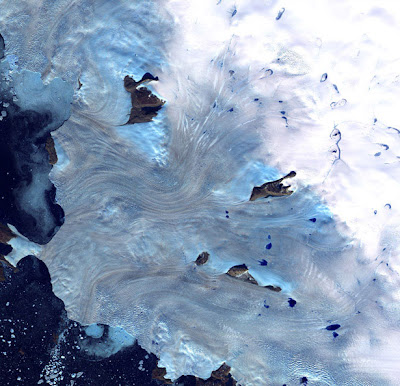
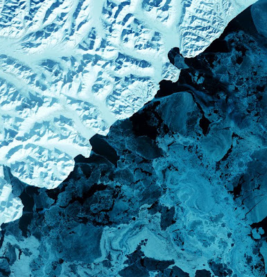
Greenland Coast – Along Greenland’s western coast, a small field of glaciers surrounds Baffin Bay.
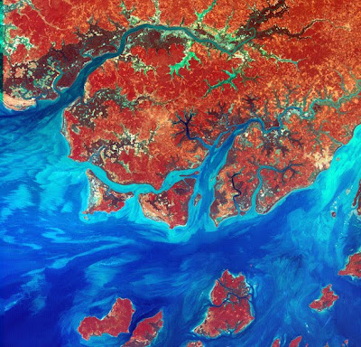
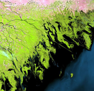
Guinea-Bissau - Guinea-Bissau is a small country in West Africa. Complex patterns can be seen in the shallow waters along its coastline, where silt carried by the Geba and other rivers washes out into the Atlantic Ocean.

Harrat Al Birk - Dark-colored volcanic cones sprout from an ancient lava field known as Harrat Al Birk along Saudi Arabia’s Red Sea coastline. Many such lava fields dot the Arabian Peninsula and range in age from 2 million to 30 million years old.

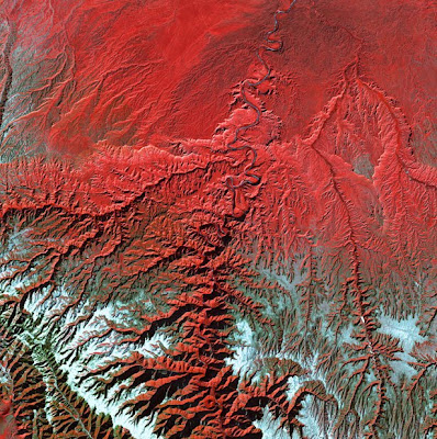
The Himalayas - Soaring, snow-capped peaks and ridges of the eastern Himalayas Mountains create an irregular white-on-red patchwork between major rivers in southwestern China. The Himalayas are made up of three parallel mountain ranges that together extend more than 2900 kilometers.
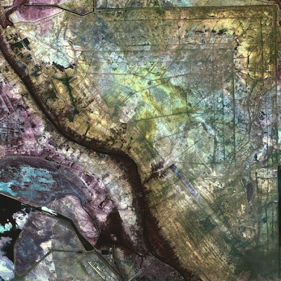
Iraqi Emplacement – In an area north of the city of Al-Basrah, Iraq, which borders Iran, a former wetland has been drained and walled off. Now littered with minefields and gun emplacements, it is a staging area for military exercises

Jau Park – Fed by multiple waterways, Brazil’s Negro River is the Amazon River’s largest tributary. The mosaic of partially-submerged islands visible in the channel disappears when rainy season downpours raise the water level.
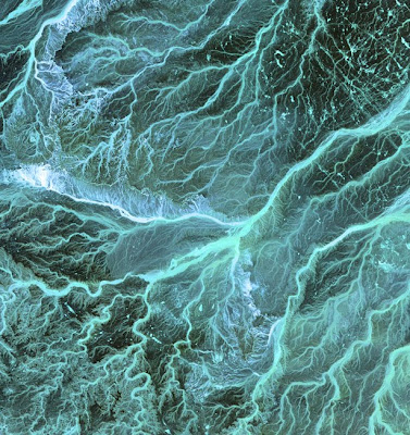
Jordan – Meandering wadis combine to form dense, branching networks across the stark, arid landscape of southeastern Jordan. The Arabic word “wadi†means a gully or streambed that typically remains dry except after drenching, seasonal rains.
©Uniquescoop
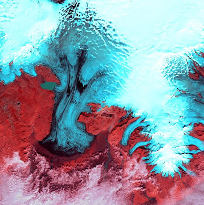
Kamchatka Peninsula – The eastern side of Russia’s Kamchatka Peninsula juts into the Pacific Ocean west of Alaska. In this winter image, a volcanic terrain is hidden under snow-covered peaks and valley glaciers feed blue ice into coastal waters.
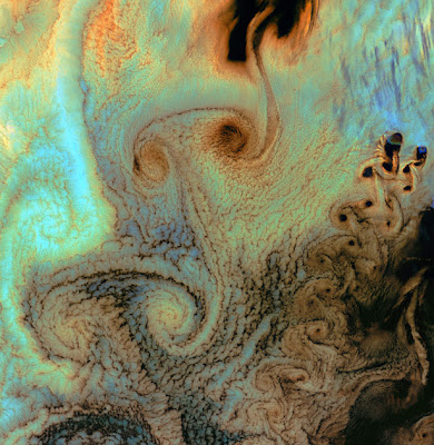
Von Karman Vortices - As air flows over and around objects in its path, spiraling eddies, known as Von Karman vortices, may form. The vortices in this image were created when prevailing winds sweeping east across the northern Pacific Ocean encountered Alaska’s Aleutian Islands.

Kilimanjaro, Tanzania - Portions of Kenya and Tanzania, Africa, can be seen in this image. The peak of Kilimanjaro is on the right; the mountain is flanked by the plains of Amboseli National Park to the north and the rugged Arusha National Park to the south and west.
Konari, Iran – The Mand River and the small town of Konari nestle in the Zagros Mountains in western Iran.
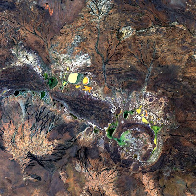
Lake Amadeus – Like frantic brushstrokes, fire scars cover the arid landscape near Lake Amadeus (upper right) in Australia’s Northern Territory. Lake Amadeus is rich in salts that have been leached out of underlying sediments. When dry, its lake bed is transformed into a glistening sheet of white salt crystals.

Lake Carnegie – Ephemeral Lake Carnegie, in Western Australia, fills with water only during periods of significant rainfall. In dry years, it is reduced to a muddy marsh.
Lake Disappointment – Surrounded by sand dunes, Lake Disappointment is an ephemeral salt lake in one of the most remote areas of Western Australia. An early explorer supposedly named the lake in 1897 after following a number of creeks that he thought would lead to a large lake; they did, but the lake’s extremely salty water was not drinkable.
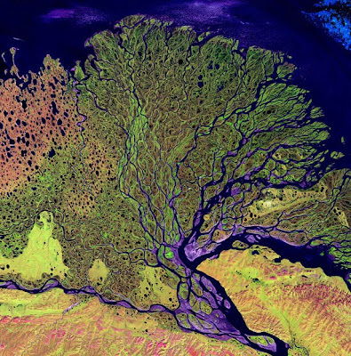
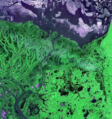
Lena Delta - The Lena River, some 2,800 miles (4,400 km) long, is one of the largest rivers in the world. The Lena Delta Reserve is the most extensive protected wilderness area in Russia. It is an important refuge and breeding grounds for many species of Siberian wildlife.
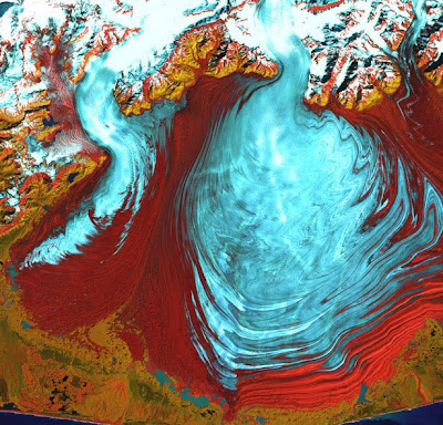
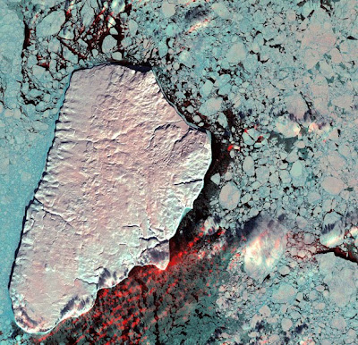
Malaspina Glacier - The tongue of the Malaspina Glacier, the largest glacier in Alaska, fills most of this image. The Malaspina lies west of Yakutat Bay and covers 1,500 sq. MI (3,880 sq. km).

Mississippi River Delta - Turbid waters spill out into the Gulf of Mexico where their suspended sediment is deposited to form the Mississippi River Delta. Like the webbing on a duck’s foot, marshes and mudflats prevail between the shipping channels that have been cut into the delta.
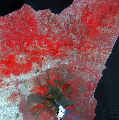
Mt. Etna - Located on the Italian island of Sicily, Mt. Etna is one of the world’s most active volcanoes. In this image of the volcano in 2001, a plume of steam and smoke rising from the crater drifts over some of the many dark lava flows that cover its slopes.

Namib Desert, Namibia – Namib-Naukluft National Park is an ecological preserve in Namibia’s vast Namib Desert. Coastal winds create the tallest sand dunes in the world here, with some dunes reaching 980 feet (300 meters) in height.
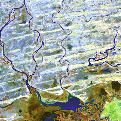
Niger River, Massina Mali – Coursing through parched, landlocked Mali in Western Africa, the Niger River skirts the edge of the dune-striped Sahara before turning sharply south to join the Bani River. At the confluence of the two rivers is an inland delta complete with narrow, twisting waterways, lagoons, and tiny islands.
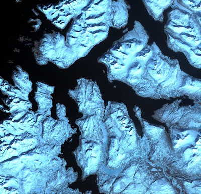
Northern Norway – Like dark fingers, cold ocean waters reach deeply into the mountainous coastline of northern Norway, defining the fjords for which the country is famous. Flanked by snow-capped peaks, some of these ice-sculpted fjords are hundreds of meters deep.
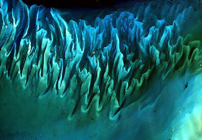
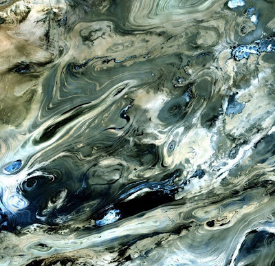
Ocean Sand, Bahamas – Though the above image may resemble a new age painting straight out of an art gallery in Venice Beach, California, it is in fact a satellite image of the sands and seaweed in the Bahamas. The image was taken by the Enhanced Thematic Mapper plus (ETM+) instrument aboard the Landsat 7 satellite. Tides and ocean currents in the Bahamas sculpted the sand and seaweed beds into these multicolored, fluted patterns in much the same way that winds sculpted the vast sand dunes in the Sahara Desert.
©Uniquescoop

The Optimist, Kalahari Desert, Namibia - On the edge of the Kalahari Desert in Namibia, sand dunes are encroaching onto once-fertile lands in the north. Healthy vegetation appears red in this image; in the center, notice the lone red dot. It is the result of a center-pivot irrigation system, evidence that at least one optimistic farmer continues to work the fields despite the approaching sand.

Parana River Delta – The Parana River delta is a huge forested marshland about 20 miles northeast of Buenos Aires, Argentina. The area is a very popular tour destination. Guided boat tours can be taken into this vast labyrinth of marsh and trees. The Parana River delta is one of the world’s greatest bird-watching destinations. This image highlights the striking contrast between dense forest and wetland marshes, and the deep blue ribbon of the Parana River.
Pinacate Volcano Field - The pockmarked terrain of Pinacate National Park in Mexico’s Sonora Province is evidence of a violent past. Among hundreds of volcanic vents and cinder cones are rare maar craters, formed when rising magma met underground water to create pockets of steam that blew nearly circular holes in the overlying crust.

Richat Structure - The so-called Richat Structure is a geological formation in the Maur Adrar Desert in the African country of Mauritania. Although it resembles an impact crater, the Richat Structure formed when a volcanic dome hardened and gradually eroded, exposing the onion-like layers of rock.
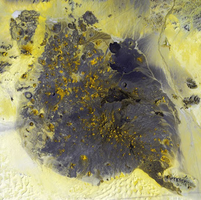
Shoemaker Crater - Resembling splotches of yellow and green paint, salt-encrusted seasonal lakes dot the floor of Western Australia’s Shoemaker impact structure. The structure was formed about 1.7 billion years ago and is currently the oldest known impact site in Australia.

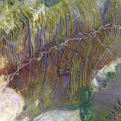
Sulaiman Mountains – The Sulaiman Mountains are a major geological feature of Pakistan and one of the bordering ranges of the Indian subcontinent.
Syrian Desert - Between the fertile Euphrates River valley and the cultivated lands of the eastern Mediterranean coast, the Syrian Desert covers parts of modern Syria, Jordan, Saudi Arabia, and Iraq.
Terkezi Oasis – A series of rocky outcroppings are a prominent feature of this Sahara Desert landscape near the Terkezi Oasis in the country of Chad.
Ugab River - Elusive, but ecologically vital, Namibia’s Ugab River only flows above ground for a few days each year. The subterranean waters underlying this ephemeral river, however, are shallow enough in places to fill hollows and sustain a wildlife population that includes the rare desert elephant.
Vatnajökull Glacier Ice Cap - Valley glaciers appear as fingers of blue ice reaching out from the Vatnajökull Glacier in Iceland’s Skaftafell National Park. The park lies on the southern edge of Vatnajökull, Europe’s largest icecap.

Volcanoes - Steep-sided volcanic cones along the Chilean-Argentinean border add texture to this “study in blue.†Of approximately 1800 volcanoes scattered across this region, 28 are active.
Volga River Delta – Where the Volga River flows into the Caspian Sea, it creates an extensive delta. The Volga Delta is comprised of more than 500 channels, and sustains the most productive fishing grounds in Eurasia.

West Fjords – The West Fjords are a series of peninsulas in northwestern Iceland. They represent less than one-eighth the country’s land area, but their jagged perimeter accounts for more than half of Iceland’s total coastline.
The Yukon Delta - An intricate maze of small lakes and waterways define the Yukon Delta at the confluence of Alaska’s Ukon and Kuskokwim Rivers with the frigid Bering Sea. Wildlife abounds on the delta and offshore where sheets of sea ice form during the coldest months of the year.
©Uniquescoop

ik zie liever satelietfoto's van de aarde zoals ie is, in plaats van deze gekleurde foto's.
maar dat is smaak he en daar valt niet over te twisten
Toch leuk om even te zien, dit soort plaatjes.
maar dat is smaak he en daar valt niet over te twisten
Toch leuk om even te zien, dit soort plaatjes.
-- Live fast, Die young and leave a beautiful corpse! --