
[USA] Onweers-Verwachting 21 feb 2010
Hier dan het eerste echte topic voor dit nieuwe forumgedeelte! Het Storm Prediction Center (SPC) heeft na een lange rustige periode een 'Slight Risk' uitgegeven voor het einde van zondagmiddag en -avond. Aan de voorzijde van een koufront kunnen er enkele 'Severe Thunderstorms' ontstaan, welke zware windstoten en grote hagel met zich mee kunnen brengen, voornamelijk in het oosten van Texas, Louisiana en het zuiden van Mississippi. Tornado's worden niet verwacht. Op de langere termijn blijft het redelijk rustig al zijn er voor woensdag en donderdag nieuwe kansen.
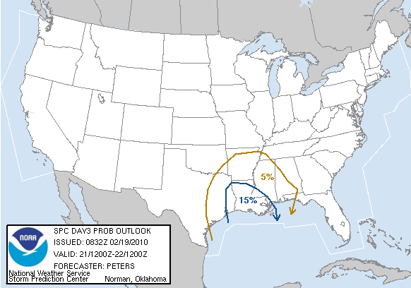
Hieronder volgt de volledige engelstalige voorspelling voor as zondag:
...There is a slgt risk of svr tstms across ern tx into parts of
lower ms valley sunday afternoon/evening...
...Synopsis...
00z gfs/ecmwf differ in the progression of the srn ca shortwave
trough as this feature tracks enewd from the srn high plains on day
3 through the srn plains to middle and lower ms valleys by 12z
monday. Ecmwf is the slower of the two models.
In the low levels...a surface low should track ewd along the red
river valley to wrn/nwrn ar by 22/00z...and then move newd into wrn
ky by 12z monday attendant to track of shortwave trough. Tstm
development is expected along a pre-frontal trough moving ewd from
central-ern tx...and along the track of the surface low and trailing
cold spreading esewd into the lower ms valley by 12z monday.
...Parts of e tx/la/parts of far srn ms...
Surface based tstm development should be greatest across ern tx into
la and parts of srn ms from sunday afternoon into sunday evening
where the quality of low level moisture return should be best.
Farther n and ne...forecast soundings suggest tstm activity should
remain elevated.
Despite the model timing difference of the gfs/ecmwf on day 3 /sun
feb 21/...each model indicates strengthening wswly mid level winds
/50-60 kt/ spreading across e tx/lower ms valley sunday afternoon/
evening. Although stronger forcing for ascent/dpva should remain
north of the slight risk area this forecast period...the srn extent
of vorticity lobe and some height falls should support deep moist
convection across the warm sector. Marginal to moderate instability
and 40-50 kt effective bulk shear suggest organized storms will be
possible mainly sunday afternoon/evening.
Bron: spc.noaa.gov | Gewijzigd: 19 februari 2010, 23:28 uur, door Narmolanya
Hier dan het eerste echte topic voor dit nieuwe forumgedeelte! Het Storm Prediction Center (SPC) heeft na een lange rustige periode een 'Slight Risk' uitgegeven voor het einde van zondagmiddag en -avond. Aan de voorzijde van een koufront kunnen er enkele 'Severe Thunderstorms' ontstaan, welke zware windstoten en grote hagel met zich mee kunnen brengen, voornamelijk in het oosten van Texas, Louisiana en het zuiden van Mississippi. Tornado's worden niet verwacht. Op de langere termijn blijft het redelijk rustig al zijn er voor woensdag en donderdag nieuwe kansen.
Hieronder volgt de volledige engelstalige voorspelling voor as zondag:
...There is a slgt risk of svr tstms across ern tx into parts of
lower ms valley sunday afternoon/evening...
...Synopsis...
00z gfs/ecmwf differ in the progression of the srn ca shortwave
trough as this feature tracks enewd from the srn high plains on day
3 through the srn plains to middle and lower ms valleys by 12z
monday. Ecmwf is the slower of the two models.
In the low levels...a surface low should track ewd along the red
river valley to wrn/nwrn ar by 22/00z...and then move newd into wrn
ky by 12z monday attendant to track of shortwave trough. Tstm
development is expected along a pre-frontal trough moving ewd from
central-ern tx...and along the track of the surface low and trailing
cold spreading esewd into the lower ms valley by 12z monday.
...Parts of e tx/la/parts of far srn ms...
Surface based tstm development should be greatest across ern tx into
la and parts of srn ms from sunday afternoon into sunday evening
where the quality of low level moisture return should be best.
Farther n and ne...forecast soundings suggest tstm activity should
remain elevated.
Despite the model timing difference of the gfs/ecmwf on day 3 /sun
feb 21/...each model indicates strengthening wswly mid level winds
/50-60 kt/ spreading across e tx/lower ms valley sunday afternoon/
evening. Although stronger forcing for ascent/dpva should remain
north of the slight risk area this forecast period...the srn extent
of vorticity lobe and some height falls should support deep moist
convection across the warm sector. Marginal to moderate instability
and 40-50 kt effective bulk shear suggest organized storms will be
possible mainly sunday afternoon/evening.
Bron: spc.noaa.gov | Gewijzigd: 19 februari 2010, 23:28 uur, door Narmolanya
"Sunshine is delicious, rain is refreshing, wind braces us up and snow is exhilarating. There is really no such thing as bad weather, only different kinds of good weather."-John Ruskin
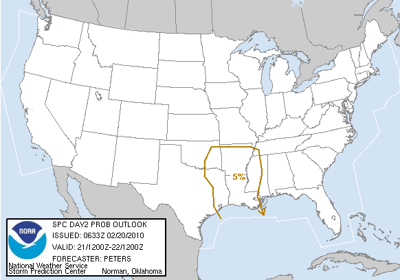
Update
De modellen geven nu aan dat er weinig kans is op 'Severe Thunderstorms'. Bij de onweersbuien die gaan ontstaan kan er wel grote hagel voorkomen.
...no svr tstm areas forecast...
...synopsis...
models differ some in the amplitude of a srn stream shortwave
trough...but are in general agreement with the timing of this
feature as it tracks from w/nw tx at 12z sunday to the mid ms/lower
oh valleys by 12z monday. surface low attendant to this trough is
expected to track from nw tx /vicinity cds/ enewd along a baroclinic
zone to nrn ar/srn mo by sunday evening and then to the lower oh
valley by end of day 2. a trailing cold front will move e/sewd from
the srn plains toward the lower ms valley and off much of the tx
gulf coast by late in the forecast period.
in the west...tstms will be possible along parts of the nrn/central
ca coast sunday afternoon/evening as a pacific shortwave trough
moves into this region.
...parts of ern ok/ar and nern tx...
elevated tstms are expected to be ongoing at 12z sunday over parts
of ok and n tx within regime of low level waa and forcing for ascent
spreading enewd ahead of progressive shortwave trough. weak
instability/shear values may support a few storms with marginally
severe hail. tstm activity should spread ewd into the ozarks to
arklatex region along the track of surface low and trailing cold
front. forecast soundings suggest some of this activity may become
surface based sunday afternoon. the lack of stronger moisture
return will tend to limit the development of stronger instability...
despite steep mid level lapse rates spreading across this region.
hail will be possible given the steep lapse rates...with this
potential greatest from nern tx into srn ar where effective bulk
shear will be stronger /around 40 kt/ for some storm organization.
weak instability will limit the severe weather threat/coverage and
preclude a categorical slight risk.
...e tx/la/srn ms...
factors that would support an organized severe weather threat across
e tx/la/srn ms are more negative in this day 2 outlook for sunday...
than were indicated in the model data for this same region/time
period in the previous day 3 outlook. the relatively poor quality
of the warm sector air mass expected across this region on sunday is
a key factor in reducing the severe probabilities...with latest
models showing weaker moisture return resulting in marginal
instability. this combined with stronger forcing for ascent
remaining n of this region along track of the shortwave trough now
suggests a lower probability for an overall severe weather threat
during day 2. nonetheless...50-60 kt wswly mid level winds
spreading across this region sunday afternoon will result in
effective shear of 40-45 kt. this will be sufficient to support
some storm organization...but aforementioned marginal instability
will limit the coverage.
Bron: spc.noaa.gov
“There is no such thing as bad weather, only different kinds of good weather.â€ÂMijn Weerblog
Maxim1110
Lid
Woonplaats: Nijmegen(ma-vr), Eindhoven(weekend)
Berichten: 4041
Lid sinds: 25 okt. 2009

Nouja onweer blijft mooi, heftig of niet. Eigenlijk wel jammer dat we in die regio's helemaal geen contactpersonen hebben die foto's enzo op zouden kunnen sturen.
Helemaal vernieuwd: mijn eigen fotografiewebsite: www.maximvanasseldonk.com
Volg me ook op twitter: https://twitter.com/#!/PhotographyMvA
En like me op facebook: http://www.facebook.com/MaximVanAsseldonkPhotography
Volg me ook op twitter: https://twitter.com/#!/PhotographyMvA
En like me op facebook: http://www.facebook.com/MaximVanAsseldonkPhotography
Citaat van Maxim1110, zaterdag 20 februari 2010, 13:38 uur
Nouja onweer blijft mooi, heftig of niet. Eigenlijk wel jammer dat we in die regio's helemaal geen contactpersonen hebben die foto's enzo op zouden kunnen sturen.
Er zijn genoeg bronnen om foto's te bekijken
Dat zal je nog wel merken Maxim1110, vorig jaar was er ook genoeg te vinden.
Er zijn genoeg bronnen om foto's te bekijken
Dat zal je nog wel merken Maxim1110, vorig jaar was er ook genoeg te vinden.
Update
De laatste modellen geven aan dat er nog steeds weinig kans is op 'Severe Thunderstorms'. Het gebied met kans op 'Severe Thunderstorms' is verkleint, wel bestaat de kans op grote hagel nog wel.

...no svr tstm areas forecast...
...Synopsis...
longwave trough will prevail over the majority of the conus on
sunday downstream of amplified/split flow along the west coast of
the conus/canada. an embedded shortwave trough...and corresponding
surface low development along a quasi-stationary boundary...is
forecast to shift northeastward from ok/north tx early in the period
to the middle ms river valley by early monday...with an associated
cold front advancing generally ese across tx/arklatex vicinity
during the day.
...eastern portions of ok/tx to lower ms river valley...
while a few severe storms will be a possibility on sunday...current
thinking is that a limited quality/opportunity for return of a
modified gulf airmass will generally preclude a
consequential/organized severe risk. scattered showers/tstms are
likely to be ongoing at the beginning of the period across much of
ok/north central tx...aided by a moderately strong low level
jet/elevated moisture transport ahead of the aforementioned southern
high plains shortwave trough. a few stronger storms capable of
mainly sub-severe hail may initially be possible.
with time...forecast mass fields imply the brunt of the large scale
forcing for ascent will shift northeastward toward the
ozarks/eventually middle ms river valley during the
day/evening...with limited forcing expected across the pre-cold
frontal warm sector across east tx/arklatex vicinity to the ms river
delta. in spite of moderately strong low/mid tropospheric wind
fields /40-50 kt effective shear/ across the warm sector...the
combination of limited moisture return...with around 60f surface
dewpoints likely to be confined to the upper tx coast and southern
portions of la/ms...and tendency for veering flow in the lowest 1
km...should keep any tornado/wind damage threat marginal through the
period.
Bron: spc.noaa.gov
De laatste modellen geven aan dat er nog steeds weinig kans is op 'Severe Thunderstorms'. Het gebied met kans op 'Severe Thunderstorms' is verkleint, wel bestaat de kans op grote hagel nog wel.
...no svr tstm areas forecast...
...Synopsis...
longwave trough will prevail over the majority of the conus on
sunday downstream of amplified/split flow along the west coast of
the conus/canada. an embedded shortwave trough...and corresponding
surface low development along a quasi-stationary boundary...is
forecast to shift northeastward from ok/north tx early in the period
to the middle ms river valley by early monday...with an associated
cold front advancing generally ese across tx/arklatex vicinity
during the day.
...eastern portions of ok/tx to lower ms river valley...
while a few severe storms will be a possibility on sunday...current
thinking is that a limited quality/opportunity for return of a
modified gulf airmass will generally preclude a
consequential/organized severe risk. scattered showers/tstms are
likely to be ongoing at the beginning of the period across much of
ok/north central tx...aided by a moderately strong low level
jet/elevated moisture transport ahead of the aforementioned southern
high plains shortwave trough. a few stronger storms capable of
mainly sub-severe hail may initially be possible.
with time...forecast mass fields imply the brunt of the large scale
forcing for ascent will shift northeastward toward the
ozarks/eventually middle ms river valley during the
day/evening...with limited forcing expected across the pre-cold
frontal warm sector across east tx/arklatex vicinity to the ms river
delta. in spite of moderately strong low/mid tropospheric wind
fields /40-50 kt effective shear/ across the warm sector...the
combination of limited moisture return...with around 60f surface
dewpoints likely to be confined to the upper tx coast and southern
portions of la/ms...and tendency for veering flow in the lowest 1
km...should keep any tornado/wind damage threat marginal through the
period.
Bron: spc.noaa.gov
“There is no such thing as bad weather, only different kinds of good weather.â€ÂMijn Weerblog
Kansen zijn erg sterk afgenomen. Er is ook geen sprake meer van een "Slight Risk". Er zullen wel onweerscellen ontstaan aan de voorkant van het naderende koufront, maar deze zullen naar alle waarschijnlijkheid niet sterk genoeg worden om 'severe' te worden. Wel kunnen er weer flinke hoeveelheden sneeuw vallen. Later in de week nieuwe kansen in Missisippi.
| Gewijzigd: 20 februari 2010, 23:23 uur, door Bronk
"Sunshine is delicious, rain is refreshing, wind braces us up and snow is exhilarating. There is really no such thing as bad weather, only different kinds of good weather."-John Ruskin
Ik zit nu in Cushing, Oklahoma en er is inderdaad kans op onweer hier... Niks zwaar... het zullen voornamelijk ingezaaide buien in het regengebied zijn met toppen tot zo'n FL300.
Koos | Gewijzigd: 21 februari 2010, 01:27 uur, door Onweergek (ZH)
Koos | Gewijzigd: 21 februari 2010, 01:27 uur, door Onweergek (ZH)
Update
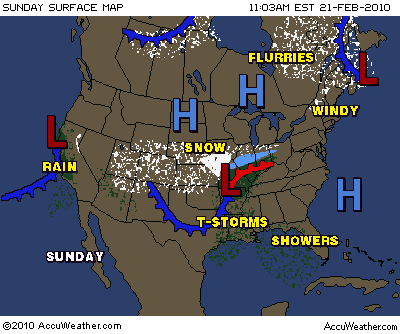
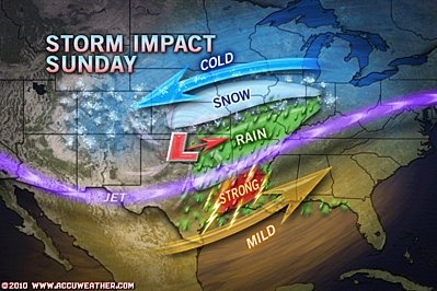
SPC Heeft onverwachts toch weer een upgrade gegeven tot een 'Slight Risk' voor het midden en zuiden van Louisiana, doordat de shear waarden hoger uitvallen dan in eerste instantie werd voorspeld. Er kunnen meerdere stormen uitgroeien tot severe. Tornado's worden hierbij niet uitgesloten en we zullen de situatie daarom op de voet volgen vanavond. Hieronder volgen 2 kaartjes van accuweather welke de situatie goed weergeeft, met daaronder de laatste update van het SPC.
accuweather.com
accuweather.com
SPC- Update
...There is a slgt risk of svr tstms over parts of far sern tx into
la...
...Arklatex into the lower ms river valley...
Well defined shortwave trough over the srn plains will continue to
lose amplitude as it ejects newd as a negatively-tilted system
towards the mid ms river valley today. This will shift strongest
vertical motion and associated 35-45 kt llj newd with time across
the mid south...although broad wly mid/upper level winds will remain
seasonably strong over tx into the lower ms river valley. Srn
stream will remain established across nrn mexico/srn tx at h25 with
generally 45-55 kt at h5 over a larger area from tx into the mid
south. at the surface...16z analysis indicates dual low structure
along a cold front extending from the ozarks into the tx south
plains. This cyclone will likely consolidate invof sern ok through
the day and deepen as it lifts newd into the lower oh river valley
tonight...allowing the cold front to surge sewd across much of tx
and into the lower ms river valley/mid south.
Despite favorable shear for organized storms...instability within
broad warm sector will remain very limited with only modified gulf
moisture source available over the wrn gulf basin. Surface dew
points should increase into the lower 60s f with sly low level winds
across ern tx/la...Although persistent stratus will diminish heating
and may act to inhibit surface-based instability.
regardless...observed 12z soundings indicate relatively steep mid
level lapse rates across this region...along with 30-40 kt effective
shear. This will likely support a few more robust/organized storms
later today and this evening spreading ewd across the lower ms river
valley. Isolated wind damage/tornado potential will hinge on
development of pockets of heating and modest surface-based
instability...although cold air aloft/steep lapse rates and
sufficient effective shear for storm-scale organization may support
large hail with the stronger cores.

spc.noaa.gov | Gewijzigd: 21 februari 2010, 19:07 uur, door Narmolanya
SPC Heeft onverwachts toch weer een upgrade gegeven tot een 'Slight Risk' voor het midden en zuiden van Louisiana, doordat de shear waarden hoger uitvallen dan in eerste instantie werd voorspeld. Er kunnen meerdere stormen uitgroeien tot severe. Tornado's worden hierbij niet uitgesloten en we zullen de situatie daarom op de voet volgen vanavond. Hieronder volgen 2 kaartjes van accuweather welke de situatie goed weergeeft, met daaronder de laatste update van het SPC.
accuweather.com
accuweather.com
SPC- Update
...There is a slgt risk of svr tstms over parts of far sern tx into
la...
...Arklatex into the lower ms river valley...
Well defined shortwave trough over the srn plains will continue to
lose amplitude as it ejects newd as a negatively-tilted system
towards the mid ms river valley today. This will shift strongest
vertical motion and associated 35-45 kt llj newd with time across
the mid south...although broad wly mid/upper level winds will remain
seasonably strong over tx into the lower ms river valley. Srn
stream will remain established across nrn mexico/srn tx at h25 with
generally 45-55 kt at h5 over a larger area from tx into the mid
south. at the surface...16z analysis indicates dual low structure
along a cold front extending from the ozarks into the tx south
plains. This cyclone will likely consolidate invof sern ok through
the day and deepen as it lifts newd into the lower oh river valley
tonight...allowing the cold front to surge sewd across much of tx
and into the lower ms river valley/mid south.
Despite favorable shear for organized storms...instability within
broad warm sector will remain very limited with only modified gulf
moisture source available over the wrn gulf basin. Surface dew
points should increase into the lower 60s f with sly low level winds
across ern tx/la...Although persistent stratus will diminish heating
and may act to inhibit surface-based instability.
regardless...observed 12z soundings indicate relatively steep mid
level lapse rates across this region...along with 30-40 kt effective
shear. This will likely support a few more robust/organized storms
later today and this evening spreading ewd across the lower ms river
valley. Isolated wind damage/tornado potential will hinge on
development of pockets of heating and modest surface-based
instability...although cold air aloft/steep lapse rates and
sufficient effective shear for storm-scale organization may support
large hail with the stronger cores.
spc.noaa.gov | Gewijzigd: 21 februari 2010, 19:07 uur, door Narmolanya
"Sunshine is delicious, rain is refreshing, wind braces us up and snow is exhilarating. There is really no such thing as bad weather, only different kinds of good weather."-John Ruskin
Maxim1110
Lid
Woonplaats: Nijmegen(ma-vr), Eindhoven(weekend)
Berichten: 4041
Lid sinds: 25 okt. 2009
Citaat van talkyr86, zaterdag 20 februari 2010, 15:36 uur
Er zijn genoeg bronnen om foto's te bekijken
Dat zal je nog wel merken Maxim1110, vorig jaar was er ook genoeg te vinden.
Enig idee waar?
Dat zal je nog wel merken Maxim1110, vorig jaar was er ook genoeg te vinden.
Enig idee waar?
Helemaal vernieuwd: mijn eigen fotografiewebsite: www.maximvanasseldonk.com
Volg me ook op twitter: https://twitter.com/#!/PhotographyMvA
En like me op facebook: http://www.facebook.com/MaximVanAsseldonkPhotography
Volg me ook op twitter: https://twitter.com/#!/PhotographyMvA
En like me op facebook: http://www.facebook.com/MaximVanAsseldonkPhotography
Het bleef al veel te lang stil op de radar, SPC heeft ondertussen het volledige waarschuwingsgebied dat over Louisiana lag weggehaald van de kaarten. Daarmee is de kans op severe weather voor vanavond in z'n geheel verdwenen.
"Sunshine is delicious, rain is refreshing, wind braces us up and snow is exhilarating. There is really no such thing as bad weather, only different kinds of good weather."-John Ruskin