
[USA] Onweersverwachting 22 februari 2010
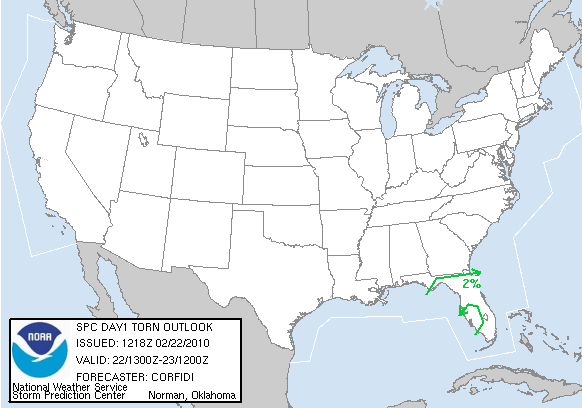
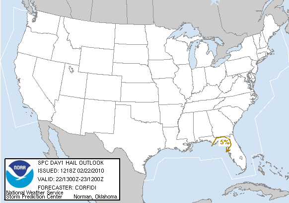
Een beetje laat voor dit topic, maar goed. Vandaag zijn er opnieuw onweerskansen in de VS, waarbij er kans is op 'Severe thunderstorms'. Deze buien zullen gaan ontstaan ten zuidwesten van een koufront behorend tot een lagedrukgebied wat zich rond de Great Lakes bevind. Bij deze buien is er kans op grote hagel, zware windstoten en er is zelfs en kleine kans op tornado's. Hierdoor is er voor een deel van Florida een 'slight risk' afgegeven.

Kans op severe thunderstorms

Kans op tornado's
Kans op grote hagel
Kans op zware windstoten
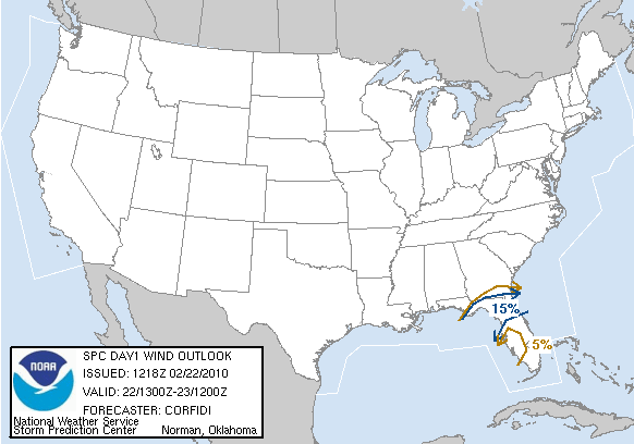
...there is a slgt risk of svr tstms over parts of n fl...
...Synopsis...
broad...low-amplitude cyclonic flow will once again prevail over the
s cntrl and sern states...downstream from slowly progressive block
over bc and the pacific nw. upr impulse now in the oh vly should
continue ne into the nrn appalachians later today/tonight...while
trailing positive-tilt vort lobe moves more slowly e across fl/ga
and the carolinas. farther s...wv imagery continues to suggest
presence of low amplitude disturbances in persistent zonal
subtropical jet over nrn mexico and the lwr rio grande vly. these
features will affect the nern gulf and fl this period.
at the sfc...main low with oh vly system will track ne across the
lwr grt lks. a separate low/wave...now evolving over the wrn fl
panhandle...should move/redevelop newd along shallow marine front
across ga today. the low should reach the nc cst late tonight.
...ern gulf cst/n fl...
satellite-derived and gps pw data attm show an area of moderate
moisture /pw 1.00-1.25 in/ over the nern gulf. this moisture will
spread ne across fl and s ga today...ahead of cold front/pre-frontal
trough associated with fl panhandle sfc wave.
pre-frontal sqln now over ga and the fl panhandle will continue e
across s ga and nrn fl. configuration of instability field with
deep unidirectional wsw flow suggests that strongest new storm
development should focus on sw side of system...i.e...over n
fl...the ern fl panhandle and the fl cstl bend...as that part of the
convective system becomes oriented roughly parallel to the mean
flow. additional storms may form s and e of the line as modest sfc
heating destabilizes the peninsula...where sbcape may increase to
500-750 j/kg.
with uvv from apparent subtropical jet disturbance moving across n
fl around time of max heating...combination of modest
instability...relatively cool mid-lvl thermal profiles...and
moderate deep shear may support embedded rotating storms and
periodic bowing segments. these may yield isold svr hail and
locally dmgg wind.
...s fl...
a separate area of storms may affect far srn fl and the keys late
today...in zone of low lvl waa/upr diffluence on ne fringe of richer
tropical air edging ne from the caribbean. the strongest storms
should remain s of the peninsula. but configuration of wind and
moisture fields may support some upstream /wnwwd/ development of
storms across the keys. given 50 kt 500 mb flow and sizable low-lvl
directional shear...these could yield a low conditional threat for
dmgg wind or a tornado into tonight.
Bron: spc.noaa.gov en Accuweather | Gewijzigd: 22 februari 2010, 16:08 uur, door Sietse
Een beetje laat voor dit topic, maar goed. Vandaag zijn er opnieuw onweerskansen in de VS, waarbij er kans is op 'Severe thunderstorms'. Deze buien zullen gaan ontstaan ten zuidwesten van een koufront behorend tot een lagedrukgebied wat zich rond de Great Lakes bevind. Bij deze buien is er kans op grote hagel, zware windstoten en er is zelfs en kleine kans op tornado's. Hierdoor is er voor een deel van Florida een 'slight risk' afgegeven.
Kans op severe thunderstorms
Kans op tornado's
Kans op grote hagel
Kans op zware windstoten
...there is a slgt risk of svr tstms over parts of n fl...
...Synopsis...
broad...low-amplitude cyclonic flow will once again prevail over the
s cntrl and sern states...downstream from slowly progressive block
over bc and the pacific nw. upr impulse now in the oh vly should
continue ne into the nrn appalachians later today/tonight...while
trailing positive-tilt vort lobe moves more slowly e across fl/ga
and the carolinas. farther s...wv imagery continues to suggest
presence of low amplitude disturbances in persistent zonal
subtropical jet over nrn mexico and the lwr rio grande vly. these
features will affect the nern gulf and fl this period.
at the sfc...main low with oh vly system will track ne across the
lwr grt lks. a separate low/wave...now evolving over the wrn fl
panhandle...should move/redevelop newd along shallow marine front
across ga today. the low should reach the nc cst late tonight.
...ern gulf cst/n fl...
satellite-derived and gps pw data attm show an area of moderate
moisture /pw 1.00-1.25 in/ over the nern gulf. this moisture will
spread ne across fl and s ga today...ahead of cold front/pre-frontal
trough associated with fl panhandle sfc wave.
pre-frontal sqln now over ga and the fl panhandle will continue e
across s ga and nrn fl. configuration of instability field with
deep unidirectional wsw flow suggests that strongest new storm
development should focus on sw side of system...i.e...over n
fl...the ern fl panhandle and the fl cstl bend...as that part of the
convective system becomes oriented roughly parallel to the mean
flow. additional storms may form s and e of the line as modest sfc
heating destabilizes the peninsula...where sbcape may increase to
500-750 j/kg.
with uvv from apparent subtropical jet disturbance moving across n
fl around time of max heating...combination of modest
instability...relatively cool mid-lvl thermal profiles...and
moderate deep shear may support embedded rotating storms and
periodic bowing segments. these may yield isold svr hail and
locally dmgg wind.
...s fl...
a separate area of storms may affect far srn fl and the keys late
today...in zone of low lvl waa/upr diffluence on ne fringe of richer
tropical air edging ne from the caribbean. the strongest storms
should remain s of the peninsula. but configuration of wind and
moisture fields may support some upstream /wnwwd/ development of
storms across the keys. given 50 kt 500 mb flow and sizable low-lvl
directional shear...these could yield a low conditional threat for
dmgg wind or a tornado into tonight.
Bron: spc.noaa.gov en Accuweather | Gewijzigd: 22 februari 2010, 16:08 uur, door Sietse
“There is no such thing as bad weather, only different kinds of good weather.â€ÂMijn Weerblog

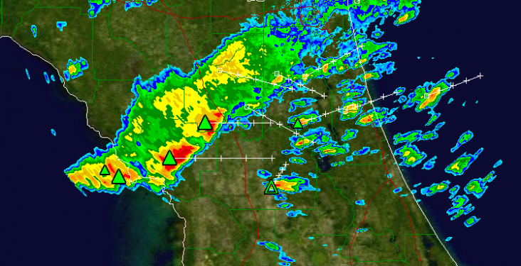
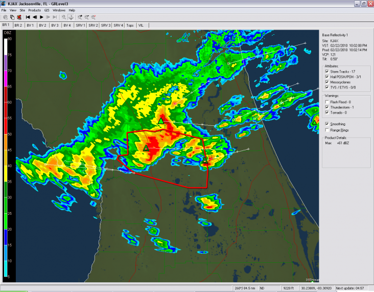
Op de radarbeelden is het koufront goed te zien, de groene driehoekjes geven aan dat er hagel in de bui zit. De hagel varieert op dit moment van 0,25 tot 0,75 inch. (0.64cm - 1.19cm)

“There is no such thing as bad weather, only different kinds of good weather.â€ÂMijn Weerblog
 | Gewijzigd: 22 februari 2010, 19:27 uur, door bjk22

Zitten al 2 aardige buien op land. Één bui heeft zelfs al hagel van 2,5cm. Op het vasteland ontwikkelen zich ook diverse buien, ook met hagel, hoewel deze hagel nog niet groot is.
“There is no such thing as bad weather, only different kinds of good weather.â€ÂMijn Weerblog
Wederom een Severe Thunderstorm warning. Er word hagel gemeld van 1" (ong 2,5 cm)
"Sunshine is delicious, rain is refreshing, wind braces us up and snow is exhilarating. There is really no such thing as bad weather, only different kinds of good weather."-John Ruskin
...A severe thunderstorm warning remains in effect until 4:45 PM EST
for Marion county...
At 4:09 PM EST...National Weather Service doppler radar continued to
indicate a severe thunderstorm capable of producing quarter size
hail...and damaging winds in excess of 60 mph. This storm was
located near Ocala...moving east at 40 mph.
Other locations in the warning include but are not limited to
Santos...Belleview...Burbank...Fort Mccoy...Silver Springs Shores...
Lynne...Ocklawaha...Moss Bluff...Salt Springs and Juniper Springs.
Bron: NWS | Gewijzigd: 22 februari 2010, 22:25 uur, door Sietse
“There is no such thing as bad weather, only different kinds of good weather.â€ÂMijn Weerblog
Alweer een severe thunderstorm waarschuwing. Er wordt bij deze bui hagel gemeld van 1,75" (zo'n 4,5cm).
EDIT: Er wordt nu al hagel met een diameter van 2" gemeld, ongeveer 5cm.
The National Weather Service in Melbourne has issued a
* severe thunderstorm warning for...
northern Volusia county in Florida
* Until 5:30 PM EST
* At 4:49 PM EST...National Weather Service meteorologists detected a
severe thunderstorm capable of producing quarter size hail...and
damaging winds in excess of 60 mph. this storm was located 7 miles
east of Barberville...or 6 miles northeast of de Leon Springs...and
moving east at 25 mph.
* Other locations in the warning include...but are not limited to...
Ormond Beach...Holly Hill...Daytona Beach...Ormond by the sea and
South Daytona
Bron: NWS | Gewijzigd: 22 februari 2010, 23:01 uur, door Sietse
“There is no such thing as bad weather, only different kinds of good weather.â€ÂMijn Weerblog