[USA] Tornado/ Onweersverwachting 8-12 maart
Storm en wind
Eerste tornadowarning voor vandaag.
"Tornado Warning for Marion County in FL until 10:45am EST."
 | Gewijzigd: 11 maart 2010, 16:19 uur, door Narmolanya
"Tornado Warning for Marion County in FL until 10:45am EST."
| Gewijzigd: 11 maart 2010, 16:19 uur, door Narmolanya
"Sunshine is delicious, rain is refreshing, wind braces us up and snow is exhilarating. There is really no such thing as bad weather, only different kinds of good weather."-John Ruskin
De Tornado warning is nu uitgebreid naar Lake County en Volusia County, en een Tornado Watch voor een groot deel van Central Florida. Dit is vlakbij de grote stad Orlando, misschien is er wat te vinden in de lokale media, het is daar net na 11 uur 's ochtends.
Live streaming video van WESH (lokaal station)
| Gewijzigd: 11 maart 2010, 17:19 uur, door ChrisZ
Live streaming video van WESH (lokaal station)
| Gewijzigd: 11 maart 2010, 17:19 uur, door ChrisZ
Maxim1110
Lid
Woonplaats: Nijmegen(ma-vr), Eindhoven(weekend)
Berichten: 4041
Lid sinds: 25 okt. 2009

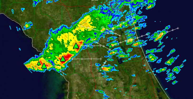
Even een vraagje: waar kan ik die radarbeelden vinden, zodat ik het ook kan volgen?
Helemaal vernieuwd: mijn eigen fotografiewebsite: www.maximvanasseldonk.com
Volg me ook op twitter: https://twitter.com/#!/PhotographyMvA
En like me op facebook: http://www.facebook.com/MaximVanAsseldonkPhotography
Volg me ook op twitter: https://twitter.com/#!/PhotographyMvA
En like me op facebook: http://www.facebook.com/MaximVanAsseldonkPhotography
"Sunshine is delicious, rain is refreshing, wind braces us up and snow is exhilarating. There is really no such thing as bad weather, only different kinds of good weather."-John Ruskin
2 Tornado warnings op dit moment.
Tornado Warning for Indian River and Okeechobee County in FL until 5:15pm EST.
Tornado Warning for Polk County in FL until 5:00pm EST.
Tornado Warning for Indian River and Okeechobee County in FL until 5:15pm EST.
Tornado Warning for Polk County in FL until 5:00pm EST.
"Sunshine is delicious, rain is refreshing, wind braces us up and snow is exhilarating. There is really no such thing as bad weather, only different kinds of good weather."-John Ruskin
Citaat van Narmolanya, donderdag 11 maart 2010, 22:20 uur
Foto's uit Florida
http://twitpic.com/17yg4k
http://twitpic.com/17yg94
Ja en dan nu nog de sites met de radarbeelden, bedankt
http://twitpic.com/17yg4k
http://twitpic.com/17yg94
Ja en dan nu nog de sites met de radarbeelden, bedankt
Zojuist is er bevestigd dat een van de slachtoffers van de tornado afgelopen nacht bij Pearson, in het ziekenhuis is overleden aan zijn verwondingen. Veel sterkte aan de nabestaanden...
"Sunshine is delicious, rain is refreshing, wind braces us up and snow is exhilarating. There is really no such thing as bad weather, only different kinds of good weather."-John Ruskin
Wederom zijn er vandaag kansen op tornado's/severe weather in de VS. De buien die vandaag voor severe weather moeten gaan zorgen, ontstaan op of nabij een koufront, wat op die moment in oostelijke richting trekt. Bij sommige van deze buien, moet men rekening houden met zware windstoten, grote hagel en het NWS/SPC spreekt zelfs over wellicht 1 of 2 tornado's.
Hier wat plaatjes om de situatie te verduidelijken:


Kans op tornado's:
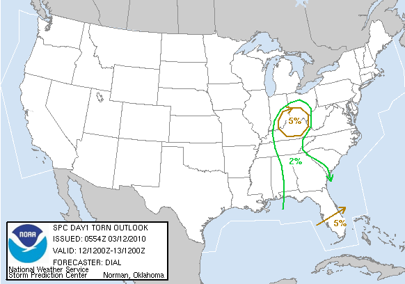
Kans op grote hagel:
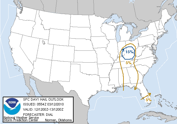
Kans op zware windstoten:

...there is a slgt risk of svr tstms over srn fl...
...there is a slgt risk of svr tstms over a portion of the oh
valley...
...there is a slgt risk of svr tstms over a portion of the sern
states...
...Synopsis...
large upper low over the central u.s. will remain dominant feature
of interest this period. the low will advance east while a series of
vorticity maxima rotate around its center. vort max now over the
lower ms valley will turn nwd into the tn valley and srn parts of
the oh valley later this afternoon and evening. farther south an
impulse embedded within the subtropical jet will continue through
the gulf and fl peninsula.
at the surface a frontal boundary extends from an occluded low over
the upper ms valley swd into the lower ms valley. this low will
continue to fill while secondary cyclogenesis commences over the tn
valley before subsequently lifting nwd into the oh valley during the
day. secondary low is developing within divergent exit region of
subtropical jet. this feature will lift newd along the carolina
coasts.
...srn fl...
richer gulf moisture is confined to south of a convective outflow
boundary that persists across srn fl. this boundary will remain
convectively active...and storms will likely be reinvigorated as a
sly low-level jet strengthens early friday in response to next
impulse embedded within the strong subtropical jet. best chance for
surface based storms will be along and south of the outflow boundary
where low 70s dewpoints reside. despite the rich low level
moisture...instability will remain limited due to widespread clouds
and weak lapse rates. hodographs and deep layer shear will support a
threat of isolated tornadoes and damaging wind with storms
developing in this region into much of the day.
boundary layer recovery will be more difficult north of the
convective outflow boundary given the likelihood of widespread
clouds and early onset of precipitation. as a result...lower severe
probabilities will be maintained across cntrl through north fl at
this time.
...tn and oh valleys...
surface low will develop nwd through the tn and oh valleys within
zone of upper divergence accompanying the nwd pivoting vort max.
potential exists for diabatic heating to destabilize the boundary
layer beneath steepening mid-level lapse rates and cold air aloft
associated with nwd ejecting impulse. greatest chance for more
substantial surface warming will be across the oh valley. a zone of
convection will shift nwd through the tn valley during the early
part of the day...eventually reaching the oh valley friday
afternoon. storms may intensify as they develop nwd where
destabilization potential will be greater. low level hodographs and
deep shear will become increasingly favorable for supercells with
isolated large hail and isolated tornadoes possible. threat is
somewhat conditional upon sufficient boundary layer destabilization.
...ern al...ga and the fl panhandle...
clouds and precipitation from convection now developing over the
lower ms valley will shift ewd into al and ga early friday. this
along with early fog will limit boundary layer destabilization
potential and decreases confidence in overall severe threat in this
region. hodographs will increase across this region as the low level
jet develops newd in association with ejecting shortwave trough.
however...at this time it appears the stable layer near the surface
will limit effective storm relative helicity and suggests storms
will remain slightly elevated. if storms can become rooted near the
surface...threat will exist for isolated damaging wind and perhaps a
tornado or two. however...threat in this region appears conditional
upon at least modest boundary layer warming.
Bron: spc.noaa.gov/Accuweather | Gewijzigd: 12 maart 2010, 14:19 uur, door Sietse
Hier wat plaatjes om de situatie te verduidelijken:
Kans op tornado's:
Kans op grote hagel:
Kans op zware windstoten:
...there is a slgt risk of svr tstms over srn fl...
...there is a slgt risk of svr tstms over a portion of the oh
valley...
...there is a slgt risk of svr tstms over a portion of the sern
states...
...Synopsis...
large upper low over the central u.s. will remain dominant feature
of interest this period. the low will advance east while a series of
vorticity maxima rotate around its center. vort max now over the
lower ms valley will turn nwd into the tn valley and srn parts of
the oh valley later this afternoon and evening. farther south an
impulse embedded within the subtropical jet will continue through
the gulf and fl peninsula.
at the surface a frontal boundary extends from an occluded low over
the upper ms valley swd into the lower ms valley. this low will
continue to fill while secondary cyclogenesis commences over the tn
valley before subsequently lifting nwd into the oh valley during the
day. secondary low is developing within divergent exit region of
subtropical jet. this feature will lift newd along the carolina
coasts.
...srn fl...
richer gulf moisture is confined to south of a convective outflow
boundary that persists across srn fl. this boundary will remain
convectively active...and storms will likely be reinvigorated as a
sly low-level jet strengthens early friday in response to next
impulse embedded within the strong subtropical jet. best chance for
surface based storms will be along and south of the outflow boundary
where low 70s dewpoints reside. despite the rich low level
moisture...instability will remain limited due to widespread clouds
and weak lapse rates. hodographs and deep layer shear will support a
threat of isolated tornadoes and damaging wind with storms
developing in this region into much of the day.
boundary layer recovery will be more difficult north of the
convective outflow boundary given the likelihood of widespread
clouds and early onset of precipitation. as a result...lower severe
probabilities will be maintained across cntrl through north fl at
this time.
...tn and oh valleys...
surface low will develop nwd through the tn and oh valleys within
zone of upper divergence accompanying the nwd pivoting vort max.
potential exists for diabatic heating to destabilize the boundary
layer beneath steepening mid-level lapse rates and cold air aloft
associated with nwd ejecting impulse. greatest chance for more
substantial surface warming will be across the oh valley. a zone of
convection will shift nwd through the tn valley during the early
part of the day...eventually reaching the oh valley friday
afternoon. storms may intensify as they develop nwd where
destabilization potential will be greater. low level hodographs and
deep shear will become increasingly favorable for supercells with
isolated large hail and isolated tornadoes possible. threat is
somewhat conditional upon sufficient boundary layer destabilization.
...ern al...ga and the fl panhandle...
clouds and precipitation from convection now developing over the
lower ms valley will shift ewd into al and ga early friday. this
along with early fog will limit boundary layer destabilization
potential and decreases confidence in overall severe threat in this
region. hodographs will increase across this region as the low level
jet develops newd in association with ejecting shortwave trough.
however...at this time it appears the stable layer near the surface
will limit effective storm relative helicity and suggests storms
will remain slightly elevated. if storms can become rooted near the
surface...threat will exist for isolated damaging wind and perhaps a
tornado or two. however...threat in this region appears conditional
upon at least modest boundary layer warming.
Bron: spc.noaa.gov/Accuweather | Gewijzigd: 12 maart 2010, 14:19 uur, door Sietse
“There is no such thing as bad weather, only different kinds of good weather.â€ÂMijn Weerblog
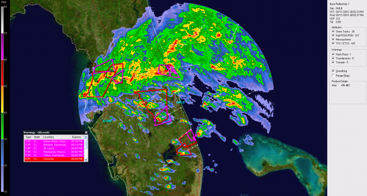
Tornado Warning in Broward County, Florida
Dat is net buiten Miami.
edit: meer informatie & radar | Gewijzigd: 12 maart 2010, 20:14 uur, door ChrisZ
Dat is net buiten Miami.
edit: meer informatie & radar | Gewijzigd: 12 maart 2010, 20:14 uur, door ChrisZ
Citaat van Chrisstorm, vrijdag 12 maart 2010, 19:23 uur
Waar halen jullie al deze radars en informatie vandaan?
Zie dit topic chris!
http://forum.onweer-online.nl/index.php?showtopic=16806
Zie dit topic chris!
http://forum.onweer-online.nl/index.php?showtopic=16806
"Sunshine is delicious, rain is refreshing, wind braces us up and snow is exhilarating. There is really no such thing as bad weather, only different kinds of good weather."-John Ruskin
Er geldt momenteel een Tornado Watch voor Zuid-Florida tot 9:00pm EST (plaatselijke tijd)
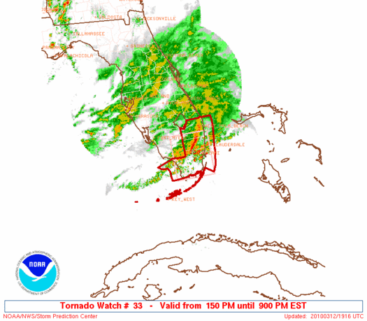
Klik hier voor de volledige Watch | Gewijzigd: 12 maart 2010, 20:21 uur, door Narmolanya
Klik hier voor de volledige Watch | Gewijzigd: 12 maart 2010, 20:21 uur, door Narmolanya
"Sunshine is delicious, rain is refreshing, wind braces us up and snow is exhilarating. There is really no such thing as bad weather, only different kinds of good weather."-John Ruskin
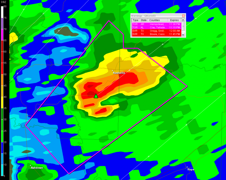
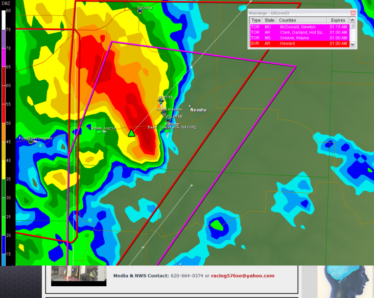
Misschien een beetje offtopic, maar wat een prachtig programma is GRlevel3.
Op dit moment :
* SEVERE THUNDERSTORM WARNING FOR...
CLAIBORNE COUNTY IN EAST TENNESSEE...
LEE COUNTY IN SOUTHWEST VIRGINIA.
Ik kan me hier uren mee vermaken
Bedankt mensen van onweer online
Op dit moment :
* SEVERE THUNDERSTORM WARNING FOR...
CLAIBORNE COUNTY IN EAST TENNESSEE...
LEE COUNTY IN SOUTHWEST VIRGINIA.
Ik kan me hier uren mee vermaken
Bedankt mensen van onweer online
Zie je in april meeuwen dan gaat het in augustus sneeuwen.
Citaat van Zippy79, vrijdag 12 maart 2010, 21:59 uur
Misschien een beetje offtopic, maar wat een prachtig programma is GRlevel3.
Op dit moment :
* SEVERE THUNDERSTORM WARNING FOR...
CLAIBORNE COUNTY IN EAST TENNESSEE...
LEE COUNTY IN SOUTHWEST VIRGINIA.
Ik kan me hier uren mee vermaken
Bedankt mensen van onweer online
Als er vragen over GRlevel3 zijn horen we het graag
Op dit moment :
* SEVERE THUNDERSTORM WARNING FOR...
CLAIBORNE COUNTY IN EAST TENNESSEE...
LEE COUNTY IN SOUTHWEST VIRGINIA.
Ik kan me hier uren mee vermaken
Bedankt mensen van onweer online
Als er vragen over GRlevel3 zijn horen we het graag
“There is no such thing as bad weather, only different kinds of good weather.â€ÂMijn Weerblog
QUOTE(MyFoxAtlanta)
Strong Storms Hit North Georgia
ATLANTA - Strong storms passed through Whitfield County in extreme north Georgia earlier Friday afternoon.
There are reports of downed trees and power lines and weather experts are trying to determine whether it was a tornado that caused the damage.
Flood warnings Also remain in effect for several Georgia rivers and creeks in the metro area.
Ik kan geen nieuwsberichten vinden over die tornado warning ten oosten van Macon gisteren.