Twee cyclonen Queensland (Australië): Gillian en Hadi
Storm en wind
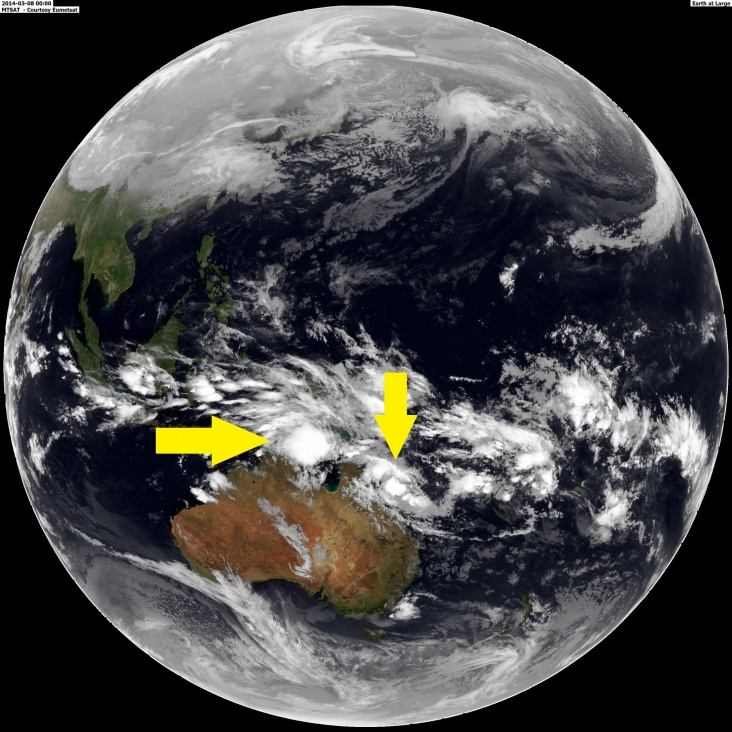
Twee cyclonen in de broedkamer bij Queensland (Australië)
Het BoM heeft waarschuwingen afgegeven voor twee lagedrukgebieden, die zich aan iedere zijde van het schiereiland Queensland bevinden. Het eerste systeem zal maandag de westkust van Queensland nabij Weipa kruisen als een categorie 2 cycloon. Het andere systeem trekt ongeveer op dezelfde tijd over de oostkust bij Bowen maar met een zwakkere intensiteit (categorie 1 cycloon).
Systeem 1
Systeem 1 ligt op ongeveer 300 km ten westen van Thursday Island en zal binnen 24-48 uur uitgroeien tot een cycloon. In het weekeind intensifeert het systeem en volgt een zuidoostelijk pad. Er worden windsnelheden van 150 km/h verwacht op zondag in het gebied tussen Cape Keerweer en Thursday Island. De kustgebieden tussen Weipa en Torres Strait Island moeten rekening houden met een gevaarlijke stormsurge. Het zeeniveau zal tot ver boven het niveau van de normale getijden stijgen. Het risico op kustoverstroming is groot. Door de zware regenval behorende bij het systeem kunnen er overstromingen ontstaan.
Systeem 2
Dit systeem ligt op ongeveer 450 km ten oost-noordoosten van Cairns en 480 km ten noordoosten van Townsville. In eerste instantie trekt dit systeem richting het zuidwesten om vervolgens naar het zuiden te gaan. Door de zware regenval kunnen er overstromingen ontstaan in het gebied tussen Cooktown en Mackay.
© onweer-online
Bron: BoM, Falk
Het BoM heeft waarschuwingen afgegeven voor twee lagedrukgebieden, die zich aan iedere zijde van het schiereiland Queensland bevinden. Het eerste systeem zal maandag de westkust van Queensland nabij Weipa kruisen als een categorie 2 cycloon. Het andere systeem trekt ongeveer op dezelfde tijd over de oostkust bij Bowen maar met een zwakkere intensiteit (categorie 1 cycloon).
Systeem 1
Systeem 1 ligt op ongeveer 300 km ten westen van Thursday Island en zal binnen 24-48 uur uitgroeien tot een cycloon. In het weekeind intensifeert het systeem en volgt een zuidoostelijk pad. Er worden windsnelheden van 150 km/h verwacht op zondag in het gebied tussen Cape Keerweer en Thursday Island. De kustgebieden tussen Weipa en Torres Strait Island moeten rekening houden met een gevaarlijke stormsurge. Het zeeniveau zal tot ver boven het niveau van de normale getijden stijgen. Het risico op kustoverstroming is groot. Door de zware regenval behorende bij het systeem kunnen er overstromingen ontstaan.
- Details of Tropical Low at 1:00 pm EST:
- .Centre located near...... 10.5 degrees South 139.3 degrees East
- .Location accuracy........ within 45 kilometres
- .Recent movement.......... towards the southeast at 13 kilometres per hour
- .Wind gusts near centre... 85 kilometres per hour and INTENSIFYING
- .Severity category........ below cyclone intensity
- .Central pressure......... 1000 hectoPascals
Systeem 2
Dit systeem ligt op ongeveer 450 km ten oost-noordoosten van Cairns en 480 km ten noordoosten van Townsville. In eerste instantie trekt dit systeem richting het zuidwesten om vervolgens naar het zuiden te gaan. Door de zware regenval kunnen er overstromingen ontstaan in het gebied tussen Cooktown en Mackay.
- Details of Tropical Low at 10:00 am EST:
- .Centre located near...... 16.1 degrees South 149.9 degrees East
- .Location accuracy........ within 55 kilometres
- .Recent movement.......... towards the west southwest at 11 kilometres per hour
- .Wind gusts near centre... 85 kilometres per hour
- .Severity category........ below cyclone intensity
- .Central pressure......... 1000 hectoPascals
© onweer-online
Bron: BoM, Falk
Every cloud has a silver lining

QLD Tropical Cyclone Warning: Cardwell to Proserpine
TROPICAL CYCLONE ADVICE NUMBER 6
Issued at 5:21 pm EST on Saturday 8 March 2014
A Cyclone WARNING has been declared for coastal areas from Cardwell to Proserpine. A Cyclone WATCH is now current for a developing tropical low for coastal and island communities from Cairns to Cardwell and Proserpine to St Lawrence.
Bron: South brisbane storms
there can be only one

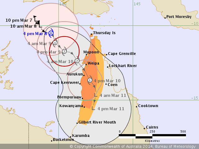
Eerste Cycloon heeft al een naam ..... Tropical Cyclone Gillian
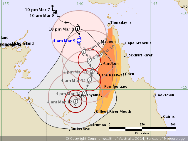
AUSTRALIAN GOVERNMENT BUREAU OF METEOROLOGY
TROPICAL CYCLONE WARNING CENTRE DARWIN
TROPICAL CYCLONE FORECAST TRACK MAP
Tropical Cyclone Gillian
Issued at 5:33 pm EST Saturday 8 March 2014.
Remarks:
Tropical cyclone Gillian is forecast to move in a southeast direction over the weekend while intensifying. The
destructive core of the tropical cyclone is expected to cross the west coast of Cape York Peninsula between
Cape Keerweer and Thursday Island during Monday morning or possibly as early as Sunday afternoon.
GALES are expected to develop between Cape Keerweer and Cape Grenville, including the Torres Strait
Islands, on Sunday morning, possibly extending further south to Kowanyama later on Sunday and to Gilbert
River Mouth during Monday.
DESTRUCTIVE winds of up to 150 km/hr may develop during Sunday afternoon or overnight between Cape
Keerweer and Thursday Island if the cyclone continues to intensify.
Coastal residents between Weipa and the Torres Strait Islands are specifically warned of the
dangerous storm tide as the cyclone crosses the coast late Sunday or early Monday. The sea is likely to rise
steadily up to a level well above the normal tide, with damaging waves and flooding of some low-lying areas
close to the shoreline. People living in areas likely to be affected by this flooding should take measures to
protect their property as much as possible and be prepared to follow instructions regarding evacuation of the
area if advised to do so by the authorities.
Very heavy rainfall that could potentially lead to flash flooding is expected to develop over the Peninsula District
tonight and persist into Sunday.
@Onweer-Online
bron:S2K/NOAA
7News
Mike Adcock
"Only A Biker Knows Why A Dog Sticks His Head Out Of A Car Window"
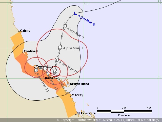
Het tweede systeem zal naar verwachting a.s. maandag uitgroeien tot Tropical Cycloon Hadi
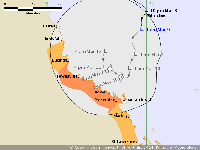
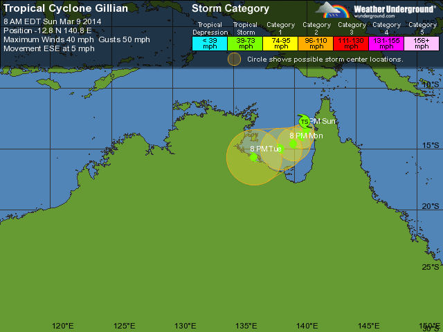
TROPICAL CYCLONE ADVICE NUMBER 9
Issued at 1:56 am EST on Sunday 9 March 2014
A Cyclone WARNING remains current for coastal areas from Cardwell to Proserpine.
A Cyclone WATCH remains current for coastal and island communities from Cairns
to Cardwell and Proserpine to St Lawrence.
At 1:00 am EST a Tropical Low was estimated to be
445 kilometres northeast of Townsville and
440 kilometres north northeast of Hamilton Island and
moving south at 6 kilometres per hour.
The tropical low has not shown signs of development in the past 24 hours,
however it may slowly intensify and develop into a tropical cyclone on Monday.
The system is expected to move in a general south southwesterly direction
before becoming slow moving and shifting to a westerly track on Monday.
GALES may develop about coastal and island communities between Cardwell and
Proserpine during Monday.
Heavy rain, which may lead to flash flooding, will develop about coastal and
nearby adjacent inland areas between Cardwell and St Lawrence from today.
As the cyclone approaches the coast, a storm tide is expected between Lucinda
and Hamilton Island. Large waves may produce minor flooding along the
foreshore. People living in areas likely to be affected by this flooding should
take measures to protect their property as much as possible and be prepared to
help their neighbours.
@Onweer-Online
bron: Bom.gov.au
"Only A Biker Knows Why A Dog Sticks His Head Out Of A Car Window"
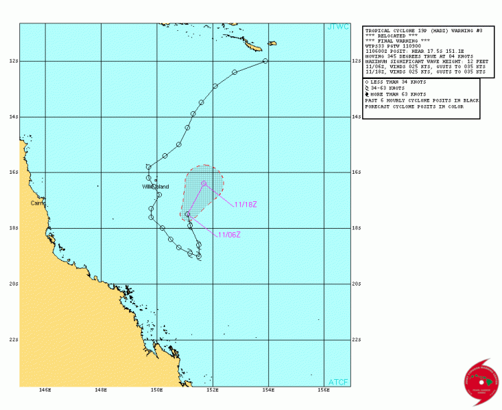
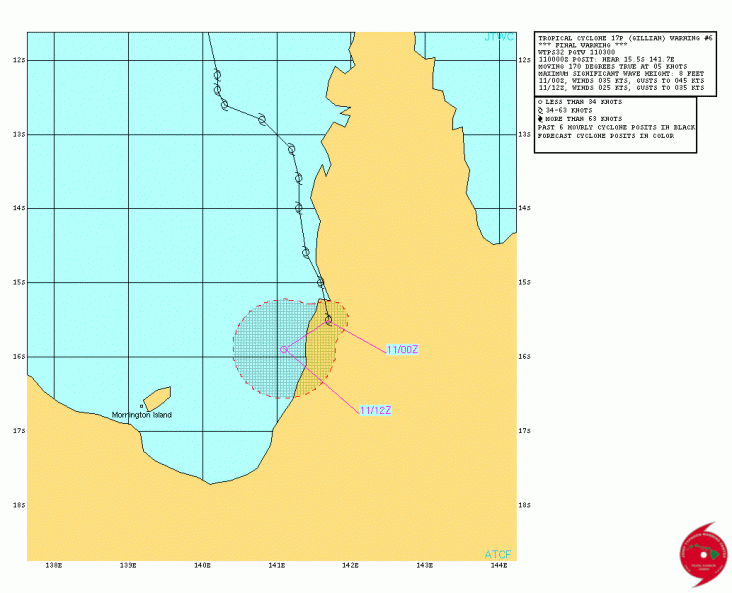
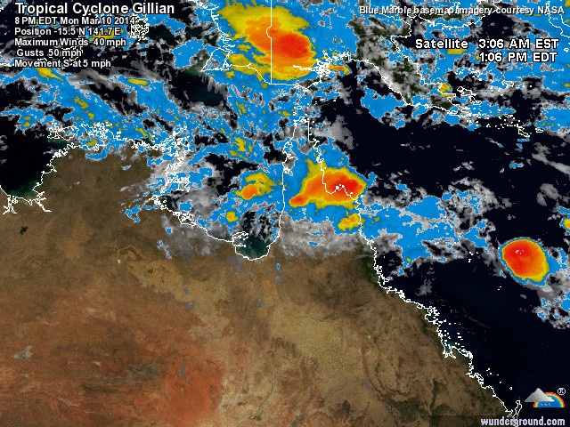
TC Gillian veranderd van koers en groeit tot een serieuze orkaan categorie 3 !
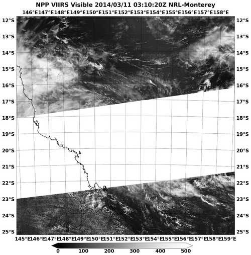
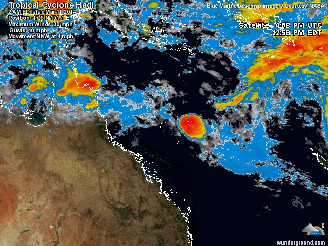
TC Hadi draait weg vd kust als een kortstondige categorie 1 orkaan, maar brengt veel neerslag met zich mee...
@Onweer-Online
bron:Bom.gov.au
TC Hadi draait weg vd kust als een kortstondige categorie 1 orkaan, maar brengt veel neerslag met zich mee...
@Onweer-Online
bron:Bom.gov.au
"Only A Biker Knows Why A Dog Sticks His Head Out Of A Car Window"
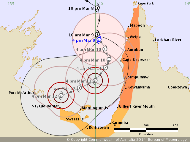
TROPICAL CYCLONE ADVICE NUMBER 14
Issued at 5:00 pm EST on Sunday 9 March 2014
A Cyclone WARNING is current for coastal areas from Gilbert River Mouth to Cape
York.
A Cyclone WATCH has been declared for coastal and island communities from the
QLD/NT border to Gilbert River Mouth.
At 4:00 pm EST Tropical Cyclone Gillian, Category 1 was estimated to be
180 kilometres west of Weipa and
190 kilometres northwest of Cape Keerweer and
moving south southeast at 6 kilometres per hour.
TROPICAL CYCLONE GILLIAN, CATEGORY 1, is expected to move in a south-southeast
direction tonight and into Monday, while intensifying. Tropical cyclone Gillian
should generally move parallel to the west coast of Cape York Peninsula over
the next couple of days, though there is still a chance that the system may
cross the coast between Cape Keerweer and Gilbert River Mouth during Monday or
Tuesday.
GALES extend 190 kilometres out from the centre and may develop between Cape
York and Pormpuraaw tonight, before extending south to Gilbert River Mouth
during Monday. Gales may extend further south and west between Gilbert River
Mouth and the QLD/NT border during Tuesday depending on the track that the
system takes over the next couple of days.
DESTRUCTIVE WINDS up to 140 km/h are expected to develop out to 65 kilometres
out from the centre during Monday and may develop between Aurukun and Kowanyama
if the system continues to intensify and moves closer to the coast.
If the cyclone approaches the coast, a storm tide may occur between Aurukun and
Kowanyama. Large waves may produce minor flooding along the foreshore. People
living in areas that may be affected by this flooding should take measures to
protect their property as much as possible and be prepared to help their
neighbours.
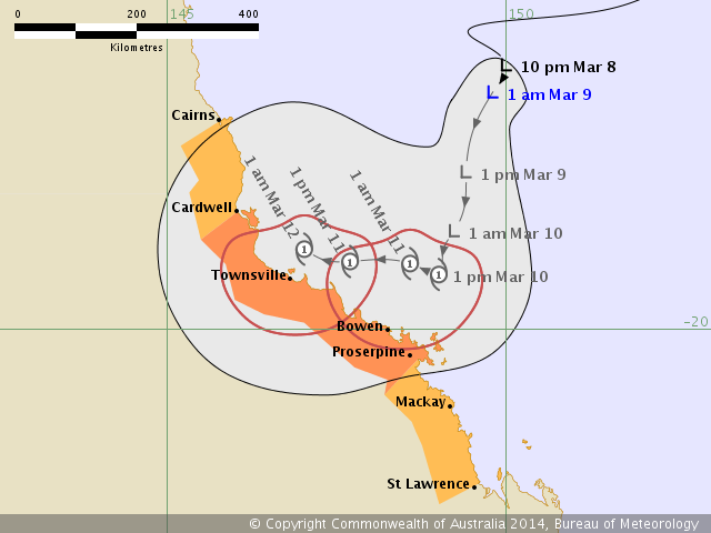
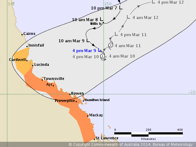
FLASH TROPICAL CYCLONE ADVICE NUMBER 15
Issued at 5:19 pm EST on Sunday 9 March 2014
This advice issued to advise on gales already occurring on the central coast.
A Cyclone WARNING remains current for coastal areas from Lucinda to St Lawrence.
A Cyclone WATCH remains current for coastal and island communities from
Innisfail to Lucinda.
At 4:00 pm EST a tropical low was estimated to be
340 kilometres east northeast of Townsville and
305 kilometres north northeast of Hamilton Island and
moving south southeast at 11 kilometres per hour.
The tropical low has not shown signs of development in the past 24 hours,
however it may slowly intensify and develop into a tropical cyclone on Monday
afternoon. The system is expected to move in a general south southeasterly
direction before becoming slow moving and shifting to a northeasterly track on
Monday. It is likely that the system will remain off the coast. However there
is greater than usual uncertainty regarding the track and there is still a
chance that it will move towards the coast.
GALES are expected to continue about central coast and island communities and
may extend to coastal comunities between Lucinda and St Lawrence during Monday.
Heavy rain, which may lead to flash flooding, will continue about coastal and
nearby adjacent inland areas between Bowen and St Lawrence overnight and during
Monday.
Large waves may produce minor flooding along the foreshore between Lucinda and
Hamilton Island. Tides will also be higher than normal. People living in areas
likely to be affected should take measures to protect their property as much as
possible and be prepared to help their neighbours.
@Onweer-Online
bron; Bom.au.gov
Issued at 5:00 pm EST on Sunday 9 March 2014
A Cyclone WARNING is current for coastal areas from Gilbert River Mouth to Cape
York.
A Cyclone WATCH has been declared for coastal and island communities from the
QLD/NT border to Gilbert River Mouth.
At 4:00 pm EST Tropical Cyclone Gillian, Category 1 was estimated to be
180 kilometres west of Weipa and
190 kilometres northwest of Cape Keerweer and
moving south southeast at 6 kilometres per hour.
TROPICAL CYCLONE GILLIAN, CATEGORY 1, is expected to move in a south-southeast
direction tonight and into Monday, while intensifying. Tropical cyclone Gillian
should generally move parallel to the west coast of Cape York Peninsula over
the next couple of days, though there is still a chance that the system may
cross the coast between Cape Keerweer and Gilbert River Mouth during Monday or
Tuesday.
GALES extend 190 kilometres out from the centre and may develop between Cape
York and Pormpuraaw tonight, before extending south to Gilbert River Mouth
during Monday. Gales may extend further south and west between Gilbert River
Mouth and the QLD/NT border during Tuesday depending on the track that the
system takes over the next couple of days.
DESTRUCTIVE WINDS up to 140 km/h are expected to develop out to 65 kilometres
out from the centre during Monday and may develop between Aurukun and Kowanyama
if the system continues to intensify and moves closer to the coast.
If the cyclone approaches the coast, a storm tide may occur between Aurukun and
Kowanyama. Large waves may produce minor flooding along the foreshore. People
living in areas that may be affected by this flooding should take measures to
protect their property as much as possible and be prepared to help their
neighbours.
FLASH TROPICAL CYCLONE ADVICE NUMBER 15
Issued at 5:19 pm EST on Sunday 9 March 2014
This advice issued to advise on gales already occurring on the central coast.
A Cyclone WARNING remains current for coastal areas from Lucinda to St Lawrence.
A Cyclone WATCH remains current for coastal and island communities from
Innisfail to Lucinda.
At 4:00 pm EST a tropical low was estimated to be
340 kilometres east northeast of Townsville and
305 kilometres north northeast of Hamilton Island and
moving south southeast at 11 kilometres per hour.
The tropical low has not shown signs of development in the past 24 hours,
however it may slowly intensify and develop into a tropical cyclone on Monday
afternoon. The system is expected to move in a general south southeasterly
direction before becoming slow moving and shifting to a northeasterly track on
Monday. It is likely that the system will remain off the coast. However there
is greater than usual uncertainty regarding the track and there is still a
chance that it will move towards the coast.
GALES are expected to continue about central coast and island communities and
may extend to coastal comunities between Lucinda and St Lawrence during Monday.
Heavy rain, which may lead to flash flooding, will continue about coastal and
nearby adjacent inland areas between Bowen and St Lawrence overnight and during
Monday.
Large waves may produce minor flooding along the foreshore between Lucinda and
Hamilton Island. Tides will also be higher than normal. People living in areas
likely to be affected should take measures to protect their property as much as
possible and be prepared to help their neighbours.
@Onweer-Online
bron; Bom.au.gov
"Only A Biker Knows Why A Dog Sticks His Head Out Of A Car Window"
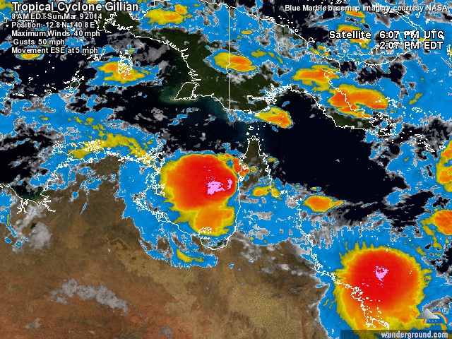
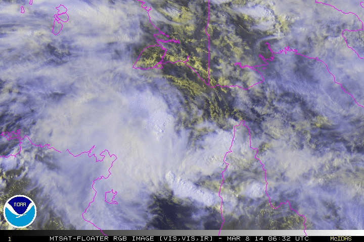
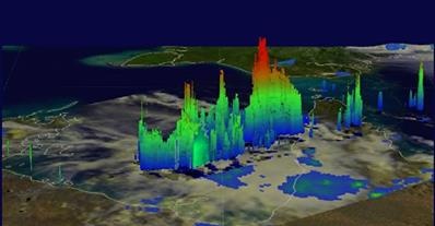
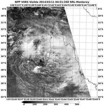
SW PACIFIC *Full Update* NASA Saw Some Power in Tropical Cyclone Gillian Before Making Landfall
NASA's TRMM satellite saw some towering thunderstorms in Tropical Cyclone Gillian before it made landfall over the Western Cape York Peninsula of Queensland, Australia.
Every cloud has a silver lining
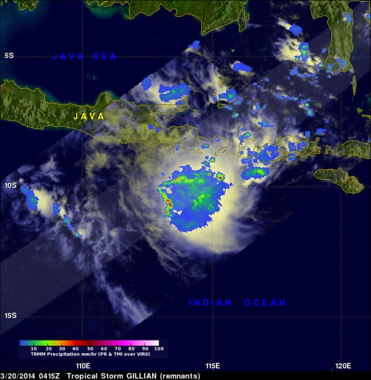
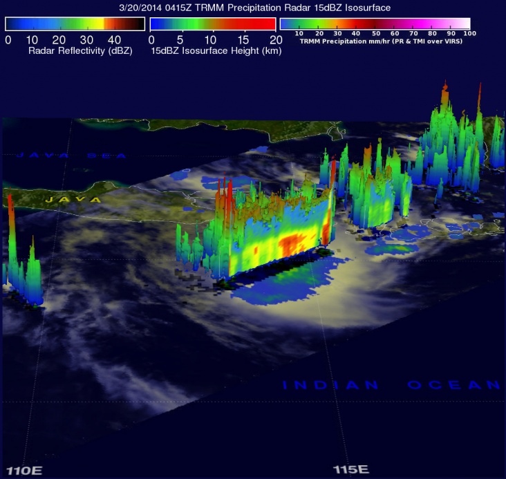
NASA's TRMM satellite continues to follow the remnants of former Tropical Cyclone Gillian as it moved from the Southern Pacific Ocean into the Southern Indian Ocean where it appears to be re-organizing. STORY/IMAGES:
Every cloud has a silver lining