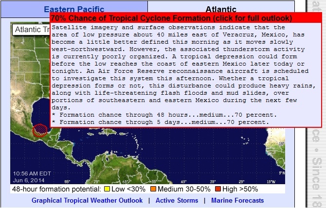
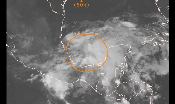
Showers and thunderstorms have recently increased near a low pressure area over the southern Bay of Campeche. Despite strong upper-level winds, some further development of this system is possible over the next day or two if the low remains offshore of eastern Mexico. An Air Force Reserve Hurricane Hunter aircraft is scheduled to investigate this system this afternoon, if necessary. This disturbance has the potential to produce extremely heavy rains and life-threatening flash floods and mud slides over portions of southeastern Mexico during the next few days.
* Formation chance through 48 hours...medium...30 percent.
* Formation chance through 5 days...medium...30 percent.
Bron: NOAA | Gewijzigd: 5 juni 2014, 17:23 uur, door Marga
Every cloud has a silver lining
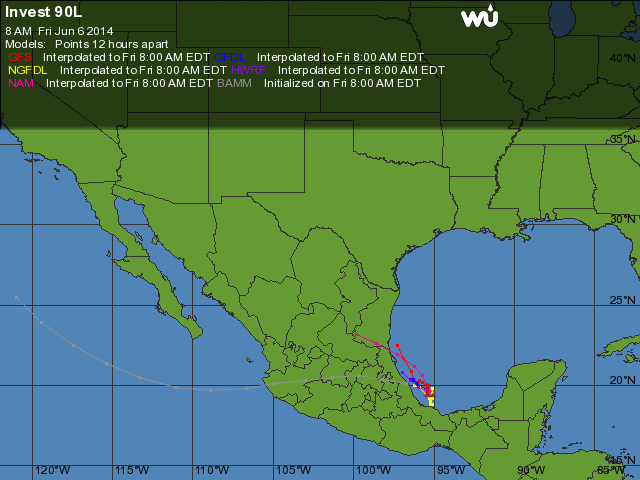
Invest 90L in Gulf of Mexico a Heavy Rain Threat for Mexico
A tropical disturbance in the Southern Gulf of Mexico's Bay of Campeche, Invest 90L, is nearly stationary, and is bringing a few heavy thunderstorms to the Gulf waters and Mexican shore along the Bay of Campeche. Satellite loops show that 90L is poorly organized, with a broad area of spin that is not well-defined, and only limited heavy thunderstorm activity. Radar out of Alvarado shows the storm has developed two low-level spiral bands near the coast that bear watching, though. Wind shear as diagnosed by University of Wisconsin CIMSS is a high 25 - 30 knots, which is keeping the system from developing. Sea surface temperatures (SSTs) in the Southern Gulf of Mexico are about 28°, which is about 0.5° above average. These warm waters do not extend to great depth, and the total heat energy available to intensify a potential storm is rather low. The Hurricane Hunters are on call to investigate 90L Thursday afternoon, if necessary.
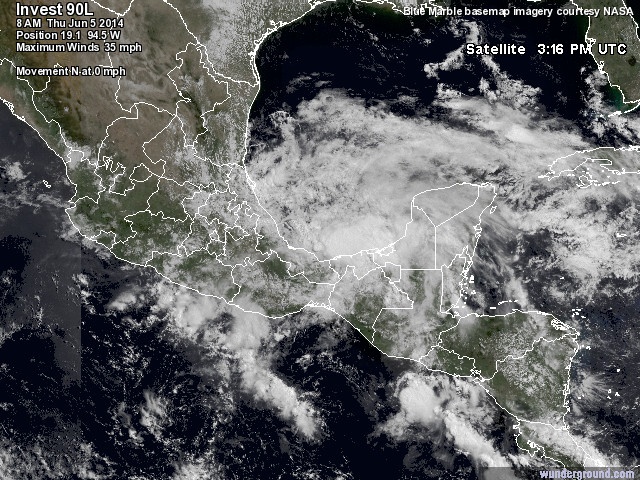
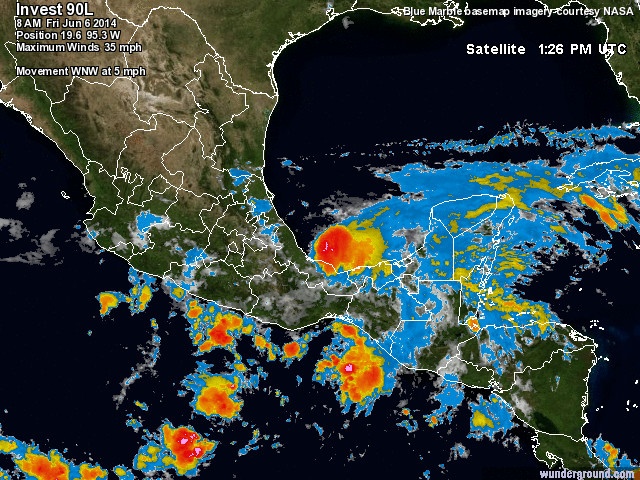
Figure 1. Latest satellite image of Invest 90L over the Gulf of Mexico, and the remnants of Boris over Southeast Mexico.
Forecast for 90L
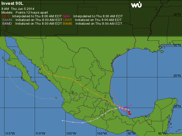
The 8 am EDT Thursday run of the SHIPS model predicts that wind shear will stay high over the Bay of Campeche through Sunday. Boris' remnants will be working their way northwards and arrive in the Bay of Campeche over the weekend, and the extra spin and moisture from Boris have the potential to aid development of 90L. However, none of the reliable genesis forecast models predict that 90L will develop over the next five days, and most of the models show the circulation moving westwards over land by Monday. In their 8 am EDT Thursday Tropical Weather Outlook, NHC gave 2-day and 5-day odds of development of 30%. The big threat from 90L is heavy rains, which will continue over Southeast Mexico into the weekend, causing flash flooding and dangerous mudslides. Several areas of 6 - 12" of rain fell in 24 hours over Mexico on Wednesday, thanks to the combined influences of 90L and Tropical Storm Boris. Boris made landfall in Southeast Mexico near 2 am EDT on Wednesday as a minimum-strength tropical storm with 40 mph winds, and dissipated Wednesday afternoon. Thus far, there are no reports of deaths or heavy damage in Mexico from the storm.
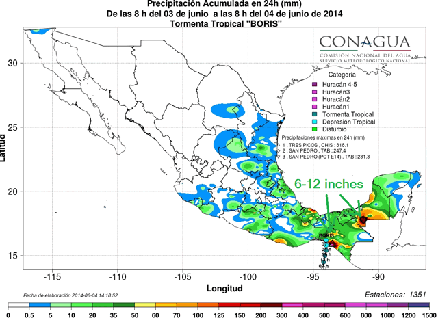
Figure 2. Total precipitation recorded for the 24 hours ending at 8 am Wednesday June 4, 2014. Image credit: Conagua.

Bron: Wunderground, Jeff Master
| Gewijzigd: 5 juni 2014, 17:50 uur, door Marga
A tropical disturbance in the Southern Gulf of Mexico's Bay of Campeche, Invest 90L, is nearly stationary, and is bringing a few heavy thunderstorms to the Gulf waters and Mexican shore along the Bay of Campeche. Satellite loops show that 90L is poorly organized, with a broad area of spin that is not well-defined, and only limited heavy thunderstorm activity. Radar out of Alvarado shows the storm has developed two low-level spiral bands near the coast that bear watching, though. Wind shear as diagnosed by University of Wisconsin CIMSS is a high 25 - 30 knots, which is keeping the system from developing. Sea surface temperatures (SSTs) in the Southern Gulf of Mexico are about 28°, which is about 0.5° above average. These warm waters do not extend to great depth, and the total heat energy available to intensify a potential storm is rather low. The Hurricane Hunters are on call to investigate 90L Thursday afternoon, if necessary.
Figure 1. Latest satellite image of Invest 90L over the Gulf of Mexico, and the remnants of Boris over Southeast Mexico.
Forecast for 90L
The 8 am EDT Thursday run of the SHIPS model predicts that wind shear will stay high over the Bay of Campeche through Sunday. Boris' remnants will be working their way northwards and arrive in the Bay of Campeche over the weekend, and the extra spin and moisture from Boris have the potential to aid development of 90L. However, none of the reliable genesis forecast models predict that 90L will develop over the next five days, and most of the models show the circulation moving westwards over land by Monday. In their 8 am EDT Thursday Tropical Weather Outlook, NHC gave 2-day and 5-day odds of development of 30%. The big threat from 90L is heavy rains, which will continue over Southeast Mexico into the weekend, causing flash flooding and dangerous mudslides. Several areas of 6 - 12" of rain fell in 24 hours over Mexico on Wednesday, thanks to the combined influences of 90L and Tropical Storm Boris. Boris made landfall in Southeast Mexico near 2 am EDT on Wednesday as a minimum-strength tropical storm with 40 mph winds, and dissipated Wednesday afternoon. Thus far, there are no reports of deaths or heavy damage in Mexico from the storm.
Figure 2. Total precipitation recorded for the 24 hours ending at 8 am Wednesday June 4, 2014. Image credit: Conagua.
Bron: Wunderground, Jeff Master
| Gewijzigd: 5 juni 2014, 17:50 uur, door Marga
Every cloud has a silver lining
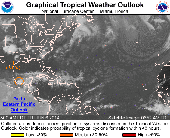
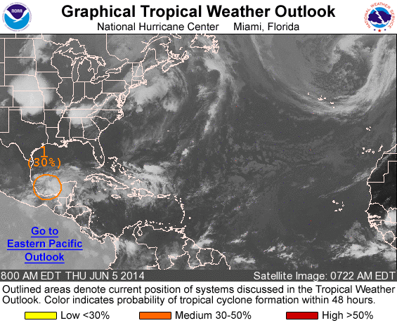
Shower and thunderstorm activity associated with a low pressure area over the southwestern Bay of Campeche has changed little in organization overnight. Although upper-level winds are expected to remain unfavorable for significant development, an Air Force Reserve reconnaissance aircraft is still scheduled to investigate this system this afternoon, if necessary. Regardless of tropical cyclone formation, this disturbance could produce heavy rains, along with life-threatening flash floods and mud slides, over portions of southeastern and eastern Mexico during the next few days.
* Formation chance through 48 hours...medium...50 percent.
* Formation chance through 5 days...medium...50 percent.
Every cloud has a silver lining