
NOCTILUCENT CLOUDS OVER SCOTLAND:
The northern summer season for noctilucent clouds (NLCs) is underway. Earth-orbiting satellites such as AIM and the International Space Station have been photographing the electric-blue clouds for days. Last night, sky watchers on Earth saw them, too. M. J. S. Ferrier sends this picture from Barassie Beach in Ayrshire, Scotland: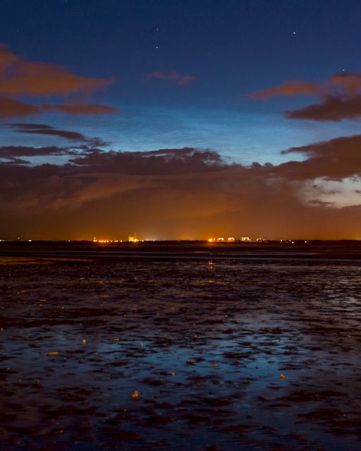
photo: M. J. S. Ferrier
The fine-structured blue clouds floating above the dark, ordinary storm clouds are the NLCs. "It was hard to tell the full extent of the display due to a storm system passing through," says Ferrier. "But the noctilucent clouds were definitely there." Jimmy Fraser of Alness, Scotland, also photographed the display. "It was a great start for the NLC season here in northern Scotland," says Fraser.
NLCs are Earth's highest clouds. Seeded by meteoroids, they float at the edge of space more than 80 km above the planet's surface. The clouds are very cold and filled with tiny ice crystals. When sunbeams hit those crystals, they glow electric-blue.
Noctilucent clouds first appeared in the 19th century after the eruption of super-volcano Krakatoa. At the time, people thought NLCs were caused by the eruption, but long after Krakatoa's ash settled, the clouds remained. In recent years, NLCs have intensified and spread with sightings as far south as Utah and Colorado. This could be a sign of increasing greenhouse gases in Earth's atmosphere.
Observing tips: Look west 30 to 60 minutes after sunset when the Sun has dipped 6o to 16o below the horizon. If you see luminous blue-white tendrils spreading across the sky, you may have spotted a noctilucent cloud.
Bron:http://www.spaceweather.com/ | Gewijzigd: 30 januari 2017, 14:15 uur, door Joyce.s
De lichtende nachtwolken (noctilucent clouds; NLC's) worden steeds helderder. Gisteren waren de eerste boven Denemarken te zien.
Op ongeveer dezelfde tijd waren ze ook zichtbaar boven Zweden en Rusland.
NLC's zijn aardes hoogste wolken, bezaaid met stof van meteorieten, zweven ze circa 80 km boven het aardoppervlak. De wolken zijn erg koud en vol ijskristallen. Als zonlicht erop weerkaatst geven ze de electrisch blauwe kleur.
De NLC's verschenen voor het eerst in de 19e eeuw, na de eruptie van supervulkaan Krakatoa. Toen dacht men dat NLC's veroorzaakt werden door de eruptie. Echter, de wolken bleven zichtbaar, lang nadat Krakatoa tot rust was gekomen.
Tegenwoordig worden ze steeds intenser en zijn ze steeds verder zuidelijk te zien, tot in Utah en Colorado.
Dit kan het teken zijn van toenemende broeikasgassen in de atmosfeer van de aarde.
Observatietips:
Kijk naar het westen - 30 tot 60 minuten na zonsondergang, als de zon 6°-16° onder de horizon is. Als je lichtgevende blauw-witte ranken in de lucht ziet, heb je waarschijnlijk NLC's gezien.
Originele bericht en foto's hieronder:
The northern season for noctilucent clouds (NLCs) is underway, and the clouds are growing brighter. "Last night, we saw the first NLCs over Denmark," reports Ruslan Merzlyakov of Nykøbing Mors. He took this picture just one hour past midnight on June 2nd:
Ruslan Merzlyakov of Nykøbing Mor
At about the same time, electric-blue clouds appeared over Sweden and Russian. The Swedish display was especially vivid.

NLCs are Earth's highest clouds. Seeded by meteoroids, they float at the edge of space more than 80 km above the planet's surface. The clouds are very cold and filled with tiny ice crystals. When sunbeams hit those crystals, they glow electric-blue.
Noctilucent clouds first appeared in the 19th century after the eruption of super-volcano Krakatoa. At the time, people thought NLCs were caused by the eruption, but long after Krakatoa's ash settled, the clouds remained. In recent years, NLCs have intensified and spread with sightings as far south as Utah and Colorado. This could be a sign of increasing greenhouse gases in Earth's atmosphere.
Observing tips: Look west 30 to 60 minutes after sunset when the Sun has dipped 6o to 16o below the horizon. If you see luminous blue-white tendrils spreading across the sky, you may have spotted a noctilucent cloud.
Bron: http://www.spaceweather.com/
| Gewijzigd: 30 januari 2017, 14:15 uur, door Joyce.s
Op ongeveer dezelfde tijd waren ze ook zichtbaar boven Zweden en Rusland.
NLC's zijn aardes hoogste wolken, bezaaid met stof van meteorieten, zweven ze circa 80 km boven het aardoppervlak. De wolken zijn erg koud en vol ijskristallen. Als zonlicht erop weerkaatst geven ze de electrisch blauwe kleur.
De NLC's verschenen voor het eerst in de 19e eeuw, na de eruptie van supervulkaan Krakatoa. Toen dacht men dat NLC's veroorzaakt werden door de eruptie. Echter, de wolken bleven zichtbaar, lang nadat Krakatoa tot rust was gekomen.
Tegenwoordig worden ze steeds intenser en zijn ze steeds verder zuidelijk te zien, tot in Utah en Colorado.
Dit kan het teken zijn van toenemende broeikasgassen in de atmosfeer van de aarde.
Observatietips:
Kijk naar het westen - 30 tot 60 minuten na zonsondergang, als de zon 6°-16° onder de horizon is. Als je lichtgevende blauw-witte ranken in de lucht ziet, heb je waarschijnlijk NLC's gezien.
Originele bericht en foto's hieronder:
The northern season for noctilucent clouds (NLCs) is underway, and the clouds are growing brighter. "Last night, we saw the first NLCs over Denmark," reports Ruslan Merzlyakov of Nykøbing Mors. He took this picture just one hour past midnight on June 2nd:
Ruslan Merzlyakov of Nykøbing Mor
At about the same time, electric-blue clouds appeared over Sweden and Russian. The Swedish display was especially vivid.
NLCs are Earth's highest clouds. Seeded by meteoroids, they float at the edge of space more than 80 km above the planet's surface. The clouds are very cold and filled with tiny ice crystals. When sunbeams hit those crystals, they glow electric-blue.
Noctilucent clouds first appeared in the 19th century after the eruption of super-volcano Krakatoa. At the time, people thought NLCs were caused by the eruption, but long after Krakatoa's ash settled, the clouds remained. In recent years, NLCs have intensified and spread with sightings as far south as Utah and Colorado. This could be a sign of increasing greenhouse gases in Earth's atmosphere.
Observing tips: Look west 30 to 60 minutes after sunset when the Sun has dipped 6o to 16o below the horizon. If you see luminous blue-white tendrils spreading across the sky, you may have spotted a noctilucent cloud.
Bron: http://www.spaceweather.com/
| Gewijzigd: 30 januari 2017, 14:15 uur, door Joyce.s
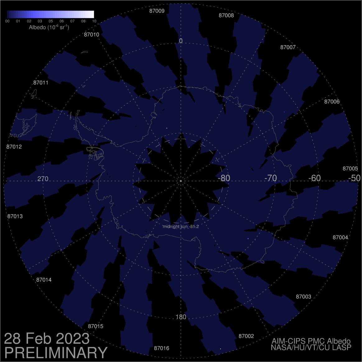
Ook AIM heeft de eerste NLC's gespot bij de poolcirkel op 19 mei, iets eerder dan normaal.
June 2, 2015
First Night-Shining Clouds of 2015 Arctic Season

NASA’s Aeronomy of Ice in the Mesosphere, or AIM, spacecraft has spotted a luminous patch of electric-blue drifting across the Arctic Circle. The sighting marks the beginning of the 2015 season for noctilucent clouds (NLCs).
The first clouds appeared on May 19, 2015, a bit earlier than researchers expected. NLCs are Earth's highest clouds. Seeded by meteoroids, they float at the edge of space more than 80 km above Earth’s surface. The clouds are very cold and filled with tiny ice crystals. When sunbeams hit those crystals, they glow electric-blue.
Noctilucent clouds are a mystery dating back to the late 19th century. Northern sky watchers first noticed them in 1885 about two years after the eruption of Krakatoa. Ash from the Indonesian volcano caused such splendid sunsets that evening sky watching became a worldwide pastime. Scientists of the day guessed they were some manifestation of volcanic dust.
Eventually Krakatoa’s ash settled and the sunsets faded, but strangely the noctilucent clouds didn’t go away. They’re still present today, stronger than ever. Researchers aren’t sure what role Krakatoa’s ash played in those early sightings.
One thing is clear, the dust behind the clouds we see now is space dust. In the past, NLCs were a polar phenomenon confined mainly to the Arctic. In recent years they have intensified and spread with sightings as far south as Utah and Colorado. This could be a sign of increasing greenhouse gases in Earth's atmosphere.
Data from AIM show that NLCs are like a great "geophysical light bulb." They turn on every year in late spring, reaching almost full intensity over a period of no more than 5 to 10 days.
Bron:http://www.nasa.gov/image-feature/goddard/aim/first-arctic-nlcs-of-2015
June 2, 2015
First Night-Shining Clouds of 2015 Arctic Season
NASA’s Aeronomy of Ice in the Mesosphere, or AIM, spacecraft has spotted a luminous patch of electric-blue drifting across the Arctic Circle. The sighting marks the beginning of the 2015 season for noctilucent clouds (NLCs).
The first clouds appeared on May 19, 2015, a bit earlier than researchers expected. NLCs are Earth's highest clouds. Seeded by meteoroids, they float at the edge of space more than 80 km above Earth’s surface. The clouds are very cold and filled with tiny ice crystals. When sunbeams hit those crystals, they glow electric-blue.
Noctilucent clouds are a mystery dating back to the late 19th century. Northern sky watchers first noticed them in 1885 about two years after the eruption of Krakatoa. Ash from the Indonesian volcano caused such splendid sunsets that evening sky watching became a worldwide pastime. Scientists of the day guessed they were some manifestation of volcanic dust.
Eventually Krakatoa’s ash settled and the sunsets faded, but strangely the noctilucent clouds didn’t go away. They’re still present today, stronger than ever. Researchers aren’t sure what role Krakatoa’s ash played in those early sightings.
One thing is clear, the dust behind the clouds we see now is space dust. In the past, NLCs were a polar phenomenon confined mainly to the Arctic. In recent years they have intensified and spread with sightings as far south as Utah and Colorado. This could be a sign of increasing greenhouse gases in Earth's atmosphere.
Data from AIM show that NLCs are like a great "geophysical light bulb." They turn on every year in late spring, reaching almost full intensity over a period of no more than 5 to 10 days.
Bron:http://www.nasa.gov/image-feature/goddard/aim/first-arctic-nlcs-of-2015


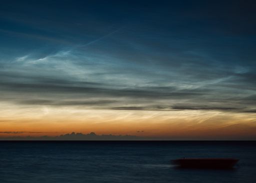
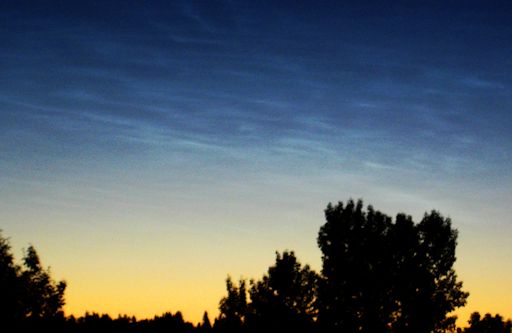
WEEKEND NOCTILUCENT CLOUDS:
All weekend long, ripples of electric-blue have criss-crossed the evening skies of northern Europe. Saturday night in Estonia, for instance, looked like this:
Voor de rest van het artikel zie:
Bron:http://www.spaceweather.com/ | Gewijzigd: 30 januari 2017, 14:16 uur, door Joyce.s
All weekend long, ripples of electric-blue have criss-crossed the evening skies of northern Europe. Saturday night in Estonia, for instance, looked like this:
Voor de rest van het artikel zie:
Bron:http://www.spaceweather.com/ | Gewijzigd: 30 januari 2017, 14:16 uur, door Joyce.s
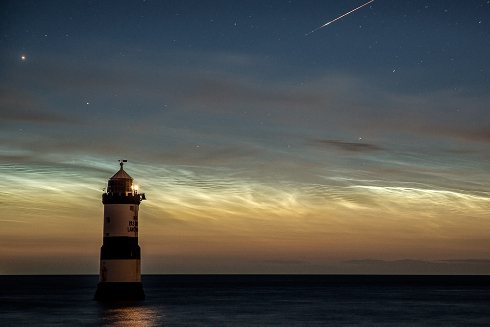
NOCTILUCENT CLOUDS REACH THE USA
For weeks, sky watchers have been reporting noctilucent clouds (NLCs) in the evening skies of Canada and northern Europe. Here they are on June 7th over Penmon Point in Anglesey, Wales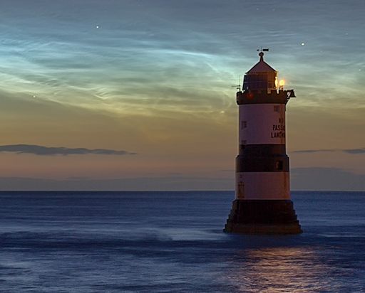
photographer Kevin Lewis
"The stunning display of noctilucent clouds lasted 4 hours," says photographer Kevin Lewis. "A meteor breaking up in one shot was an added bonus."
photographer Kevin Lewis
The 2015 season for NLCs started on May 19th when NASA's AIM spacecraft spotted a patch of electric blue over the Arctic Circle. Since then, the clouds have been creeping south and, on June 8-9, they crossed the border into the lower 48 US states. "I caught sight of them around 3:45 a.m. local time," reports Dustin Guy, who sends this picture from Seattle, Washington:
photographer Kevin Lewis
"I had to do a double take," says Guy. "It's been awhile since I last saw them!" Electric-blue ripples were also sighted in Polebridge, Montana.
Noctilucent clouds first appeared in the 19th century. At the time, they were a polar phenomenon usually restricted to regions around the Arctic and Antarctic Circles. In recent years, NLCs have intensified and spread with sightings as far south as Utah and Colorado. This could be a sign of increasing greenhouse gases in Earth's atmosphere.
At the moment, NLCs over the USA are little more than wan ripples. As summer unfolds, however, they could turn into something truly bright and eye-catching. Observing tips: Look west 30 to 60 minutes after sunset when the sun has dipped 6o to 16o below the horizon. If you see luminous blue-white tendrils spreading across the sky, you may have spotted a noctilucent cloud.
Bron: http://www.spaceweather.com/ | Gewijzigd: 30 januari 2017, 14:17 uur, door Joyce.s
ELECTRIC-BLUE MEETS AURORA-GREEN
As predicted, a solar wind stream hit Earth's magnetic field on Sunday, June 14th, sparking a minor geomagnetic storm. People in Canada were already outdoors watching noctilucent clouds (NLCs) when the sky filled with a diffuse green glow. Mike Isaak sends this picture from Edmonton, Alberta: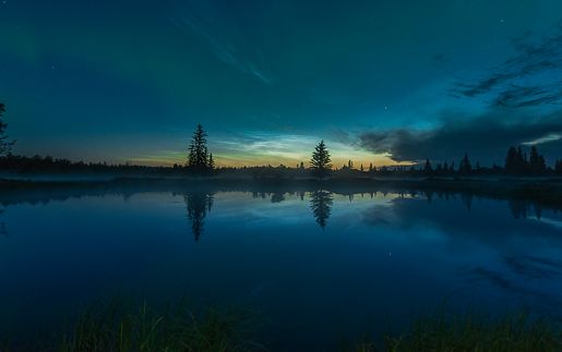
photo Mike Isaak
"Green auroras are very pretty alongside electric-blue noctilucent clouds," says Isaak. "What a night!"
High-latitude sky watchers should remain alert for both colors tonight. Seeded by meteoroids and (some say) boosted by climate change, noctilucent clouds have been growing in brightness in recent weeks. Meanwhile, NOAA forecasters estimate a 45% chance of geomagnetic storms on June 15th as the solar wind continues to blow.
Bron:http://www.spaceweather.com/ | Gewijzigd: 30 januari 2017, 14:17 uur, door Joyce.s