
El Niño
El Niño zorgt voor opwarming van het zeewater langs de evenaar in de oostelijke Stille Oceaan. Dit heeft effecten voor het weer in grote delen van de wereld.
El Niño was oorspronkelijk een sterke opwarming van de Stille Oceaan voor de kust van Noord-Peru en Ecuador. Tegenwoordig wordt de vaak daarmee samenhangende opwarming langs de evenaar tot het midden van de Stille Oceaan met deze naam aangeduid. In dit gebied komt normaal juist koel water uit de diepere oceaan naar boven. El Niño duurt gemiddeld een half jaar en het oppervlak van de oceaan kan langs de evenaar tot drie graden warmer zijn dan normaal voor de tijd van het jaar. De piek ligt vaak in december, vandaar de benaming El Niño wat “het (Kerst)kindje” betekent.
Wat veroorzaakt El Niño?
De opwarming is zo sterk en duurt zo lang omdat de passaatwind boven de Stille Oceaan door El Niño in kracht afneemt, wat de opwarming weer versterkt. Welk jaar El Niño ontstaat, wordt bepaald door twee samenhangende factoren. De kans op El Niño wordt vergroot door een langzame opbouw van warm water langs de evenaar in de Stille Oceaan. Dat wordt vervolgens omgezet in een opwarming in het oosten door periodes met westenwind in de westelijke Stille Oceaan in het voorjaar, die voor een groot gedeelte onvoorspelbaar zijn.
Is El Niño te voorspellen?
De huidige generatie weermodellen kan El Niño ongeveer een half jaar van te voren voorspellen. Dit jaar was in het voorjaar duidelijk dat de kans op El Niño groot was; in de zomer werd het zeker dat hij er echt zou komen. In september werd duidelijk hoe sterk El Niño zou worden. Vorig jaar was de kans ook groot in het voorjaar, maar bleek in de zomer dat El Niño uiteindelijk heel zwak zou blijven.
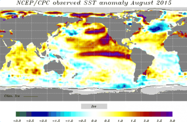
Kaart van seizoensverwachting van NCEP/CPC van augustus 2015 waarbij de opwarming van de Stille Oceaan te zien is. De rode kleur geeft de warmere watertemperatuur dan normaal aan.
Waarom is El Niño belangrijk?
Gedurende El Niño trekt het regengebied dat normaal boven Zuidoost-Azië ligt naar de Stille Oceaan. Dit brengt niet alleen droogte in Indonesië (tot oktober) en de Filippijnen (vanaf oktober) met zich mee, maar verandert ook het weer in grote delen van de wereld. De invloeden verspreiden zich langs een aantal hoofdrichtingen.
De eerste keten van effecten gaat de wereld rond door de tropen. Hierdoor worden de noordkust van Zuid-Amerika en de eilanden daarvoor droger, Oost-Afrika in het najaar natter en zuidelijk Afrika in hun zomer wat droger. Er is ook een zwak effect op regen in de Sahel. De hele tropen warmen ook op, waardoor de wereldgemiddelde temperatuur het jaar na El Niño altijd wat hoger uitvalt.
De andere twee richtingen zijn bogen over de Stille oceaan naar Noord- en Zuid-Amerika. Zuidoost-China wordt wat natter, Canada heeft meestal een wat zachtere winter en het zuiden van de VS en Mexico krijgen vaak koeler, natter weer. Op het zuidelijk halfrond wordt Oost-Australië vaak iets droger en krijgen Zuid-Brazilië en Uruguay juist meer regen. Deze effecten hangen ook sterk van het seizoen af.
Lange termijn weersverwachtingen
Veel weerinstituten maken verwachtingen voor het gemiddelde weer tot een half jaar vooruit. De meeste voorspellende waarde komt door El Niño, dus in een jaar met een grote El Niño zoals 2015/2016 geven deze verwachtingen relatief grote afwijkingen van het gemiddelde weer. Een samenvatting en een lijstje van dit soort verwachtingen staat op de KNMI seizoensverwachtingenpagina. Numerieke verwachtingen kunnen bij weerproviders gekocht worden. Het blijven echter kansverwachtingen, net zoals weersverwachtingen op een termijn van een aantal dagen.
Effecten in Europa?
Europa ligt buiten de belangrijkste banen met invloeden van El Niño. De effecten zijn hier dan ook zeer klein. In Spanje en Portugal valt in de herfst bij El Niño iets meer regen. In het voorjaar na een sterke El Niño krijgen we in Nederland en verder naar het oosten vaak een nat voorjaar, terwijl Oost-Spanje dan iets droger en warmer is. In delen van Scandinavië is de winter bij El Niño gemiddeld wat strenger dan normaal, maar op het winterweer in Nederland heeft El Niño geen aantoonbare invloed.
http://www.knmi.nl
NASA Studying 2015 El Niño Event As Never Before
Every two to seven years, an unusually warm pool of water -- sometimes two to three degrees Celsius higher than normal – develops across the eastern tropical Pacific Ocean to create a natural short-term climate change event. This warm condition, known as El Niño, affects the local aquatic environment, but also spurs extreme weather patterns around the world, from flooding in California to droughts in Australia. This winter, the 2015-16 El Niño event will be better observed from space than any previous El Niño.
This year's El Niño is already strong and appears likely to equal the event of 1997-98, the strongest El Niño on record, according to the World Meteorological Organization. All 19 of NASA's current orbiting Earth-observing missions were launched after 1997. In the past two decades, NASA has made tremendous progress in gathering and analyzing data that help researchers understand more about the mechanics and global impacts of El Niño.
“El Niño is a fascinating phenomenon because it has such far-reaching and diverse impacts. The fact that fires in Indonesia are linked with circulation patterns that influence rainfall over the United States shows how complex and interconnected the Earth system is,” said Lesley Ott, research meteorologist at NASA’s Goddard Space Flight Center, Greenbelt, Maryland.
Using NASA satellite observations in tandem with supercomputer processing power for modeling systems, scientists have a comprehensive suite of tools to analyze El Niño events and their global impacts as never before. Throughout this winter, NASA will share the latest scientific insights and imagery updates related to El Niño.
For instance, scientists are learning how El Niño affects the year-to-year variability for fire seasons in the western United States, Amazon and Indonesia. El Niño may also affect the yearly variability of the ground-level pollutant ozone that severely affects human health. Researchers will be keenly focused on how the current El Niño will affect the drought in California.
“We still have a lot to learn about these connections, and NASA's suite of satellites will help us understand these processes in a new and deeper way,” said Ott.

This visualization shows side by side comparisons of Pacific Ocean sea surface height (SSH) anomalies of what is presently happening in 2015 with the Pacific Ocean signal during the famous 1997 El Niño. These 1997 and 2015 El Niño animations were made from data collected by the TOPEX/Poseidon (1997) and the OSTM/Jason-2 (2015) satellites.
Credits: NASA's Jet Propulsion Laboratory
Download this visualization in alternate formats
Many NASA satellites observe environmental factors that are associated with El Niño evolution and its impacts, including sea surface temperature, sea surface height, surface currents, atmospheric winds and ocean color. The joint NASA/NOAA/CNES/EUMETSAT Jason-2 satellite measures sea surface height, which is especially useful in quantifying the heat stored and released by the oceans during El Niño years.
NASA satellites also help scientists see the global impact of El Niño. The warmer than normal eastern Pacific Ocean has far-reaching effects worldwide. These events spur disasters like fires and floods. They change storm tracks, cloud cover and other weather patterns, and they have devastating effects on fisheries and other industries.
NASA’s Earth-observing satellites help monitor those and other impacts by measuring land and ocean conditions that both influence and are affected by El Niño. For instance, NASA’s Global Precipitation Measurement Mission provides worldwide precipitation measurements every three hours. NASA’s Soil Moisture Active Passive mission measures soil moisture in the top layer of land. Both of these satellites are useful for monitoring drought, improving flood warnings and watching crop and fishing industries.
“NASA is at the forefront in providing key observations of El Niño and advancing our understanding of its role in shaping Earth’s weather and climate patterns,” said Duane Waliser, chief scientist of the Earth Science and Technology Directorate at NASA’s Jet Propulsion Laboratory in Pasadena, California.
Bron:http://www.nasa.gov/feature/goddard/nasa-studying-2015-el-nino-event-as-never-before
Every two to seven years, an unusually warm pool of water -- sometimes two to three degrees Celsius higher than normal – develops across the eastern tropical Pacific Ocean to create a natural short-term climate change event. This warm condition, known as El Niño, affects the local aquatic environment, but also spurs extreme weather patterns around the world, from flooding in California to droughts in Australia. This winter, the 2015-16 El Niño event will be better observed from space than any previous El Niño.
This year's El Niño is already strong and appears likely to equal the event of 1997-98, the strongest El Niño on record, according to the World Meteorological Organization. All 19 of NASA's current orbiting Earth-observing missions were launched after 1997. In the past two decades, NASA has made tremendous progress in gathering and analyzing data that help researchers understand more about the mechanics and global impacts of El Niño.
“El Niño is a fascinating phenomenon because it has such far-reaching and diverse impacts. The fact that fires in Indonesia are linked with circulation patterns that influence rainfall over the United States shows how complex and interconnected the Earth system is,” said Lesley Ott, research meteorologist at NASA’s Goddard Space Flight Center, Greenbelt, Maryland.
Using NASA satellite observations in tandem with supercomputer processing power for modeling systems, scientists have a comprehensive suite of tools to analyze El Niño events and their global impacts as never before. Throughout this winter, NASA will share the latest scientific insights and imagery updates related to El Niño.
For instance, scientists are learning how El Niño affects the year-to-year variability for fire seasons in the western United States, Amazon and Indonesia. El Niño may also affect the yearly variability of the ground-level pollutant ozone that severely affects human health. Researchers will be keenly focused on how the current El Niño will affect the drought in California.
“We still have a lot to learn about these connections, and NASA's suite of satellites will help us understand these processes in a new and deeper way,” said Ott.
This visualization shows side by side comparisons of Pacific Ocean sea surface height (SSH) anomalies of what is presently happening in 2015 with the Pacific Ocean signal during the famous 1997 El Niño. These 1997 and 2015 El Niño animations were made from data collected by the TOPEX/Poseidon (1997) and the OSTM/Jason-2 (2015) satellites.
Credits: NASA's Jet Propulsion Laboratory
Download this visualization in alternate formats
Many NASA satellites observe environmental factors that are associated with El Niño evolution and its impacts, including sea surface temperature, sea surface height, surface currents, atmospheric winds and ocean color. The joint NASA/NOAA/CNES/EUMETSAT Jason-2 satellite measures sea surface height, which is especially useful in quantifying the heat stored and released by the oceans during El Niño years.
NASA satellites also help scientists see the global impact of El Niño. The warmer than normal eastern Pacific Ocean has far-reaching effects worldwide. These events spur disasters like fires and floods. They change storm tracks, cloud cover and other weather patterns, and they have devastating effects on fisheries and other industries.
NASA’s Earth-observing satellites help monitor those and other impacts by measuring land and ocean conditions that both influence and are affected by El Niño. For instance, NASA’s Global Precipitation Measurement Mission provides worldwide precipitation measurements every three hours. NASA’s Soil Moisture Active Passive mission measures soil moisture in the top layer of land. Both of these satellites are useful for monitoring drought, improving flood warnings and watching crop and fishing industries.
“NASA is at the forefront in providing key observations of El Niño and advancing our understanding of its role in shaping Earth’s weather and climate patterns,” said Duane Waliser, chief scientist of the Earth Science and Technology Directorate at NASA’s Jet Propulsion Laboratory in Pasadena, California.
Bron:http://www.nasa.gov/feature/goddard/nasa-studying-2015-el-nino-event-as-never-before
Klimaatfenomeen El Niño over hoogtepunt heen
Het Klimaatfenomeen El Niño is voorbij zijn hoogtepunt, maar blijft het klimaat wereldwijd nog wel beïnvloeden.Dat heeft het VN-agentschap Wereld Meteorologische Organisatie (WMO) donderdag gemeld. El Niño verzwakt in de komende maanden en verdwijnt in de lente van dit jaar.
De temperatuur in delen van de Stille Oceaan was vorig jaar 2 graden hoger dan het gemiddelde. ''We zijn net getuige geweest van een van de krachtigste El Niño's ooit, die extreem weer in landen op alle continenten heeft veroorzaakt en geholpen heeft de temperatuur wereldwijd tot recordhoogte op te stuwen'', zei de secretaris-generaal van de WMO, Petteri Taalas.
''Delen van Zuid-Amerika en Oost-Afrika moeten nog bijkomen van slagregens en overstromingen. De economische en humanitaire last van droogte wordt steeds duidelijker in zuidelijk Afrika en de Hoorn van Afrika, centraal Amerika en andere gebieden.''
Door: ANP
Bron:http://www.nu.nl/buitenland/4216800/klimaatfenomeen-el-nio-hoogtepunt-heen.html | Gewijzigd: 25 april 2017, 12:12 uur, door Joyce.s
NASA Examines El Niño's Impact on Ocean’s Food Source
El Niño years can have a big impact on the littlest plants in the ocean, and NASA scientists are studying the relationship between the two.
In El Niño years, huge masses of warm water – equivalent to about half of the volume of the Mediterranean Sea – slosh east across the Pacific Ocean towards South America. While this warm water changes storm systems in the atmosphere, it also has an impact below the ocean’s surface. These impacts, which researchers can visualize with satellite data, can ripple up the food chain to fisheries and the livelihoods of fishermen.

Strong El Nino events have a big impact on phytoplankton (in green), especially when the warm water pushes far to the east of the Pacific Ocean, as in 1997.
Credits: NASA/GoddardEl Niño’s mass of warm water puts a lid on the normal currents of cold, deep water that typically rise to the surface along the equator and off the coast of Chile and Peru, said Stephanie Uz, ocean scientist at Goddard Space Flight Center in Greenbelt, Maryland. In a process called upwelling, those cold waters normally bring up the nutrients that feed the tiny organisms, which form the base of the food chain.
"An El Niño basically stops the normal upwelling," Uz said. "There’s a lot of starvation that happens to the marine food web." These tiny plants, called phytoplankton, are fish food – without them, fish populations drop, and the fishing industries that many coastal regions depend on can collapse.
With NASA satellite data, and ocean color software called SeaDAS, developed at the Ocean Biology Processing Group at Goddard, Uz has been mapping where these important phytoplankton appear. Orbiting instruments like the Moderate Resolution Imaging Spectrometer on the Aqua satellite, and the Visible Infrared Imaging Radiometer Suite on the Suomi NPP satellite collect data on the color of the ocean. From shades of blue and green, scientists can calculate the amount of green chlorophyll – and therefore the amount of phytoplankton present.
The ocean color maps, based on a month’s worth of satellite data, can show that El Niño impact on phytoplankton. In December 2015, at the peak of the current El Niño event, there was more blue – and less green chlorophyll – in the Pacific Ocean off of Peru and Chile, compared to the previous year. Uz and her colleagues are also watching as the El Niño weakens this spring, to see when and where the phytoplankton reappear as the upwelling cold water brings nutrients back to the region.
"They can pop back up pretty quickly, once they have a source of nutrients," Uz said.
Researchers can also examine the differences in ocean color between two different El Niño events. During the large 1997-1998 El Niño event, the green chlorophyll virtually disappeared from the coast of Chile. This year’s event, while it caused a drop in chlorophyll primarily along the equator, was much less severe for the coastal phytoplankton population. The reason – the warmer-than-normal waters associated with the two El Niño events were centered in different geographical locations. In 1997-1998, the biggest ocean temperature abnormalities were in the eastern Pacific Ocean; this year the focus was in the central ocean. This difference impacts where the phytoplankton can feed on nutrients, and where the fish can feed on phytoplankton.
"When you have an East Pacific El Niño, like 1997-1998, it has a much bigger impact on the fisheries off of South America," Uz said. But Central Pacific El Niño events, like this year’s, still have an impact on ocean ecosystems, just with a shift in location. Researchers are noting reduced food available along the food chain around the Galapagos Islands, for example. And there has been a drop in phytoplankton off the coast of South America, just not as dramatically as before.

Differences in December phytoplankton abundances are visualized for three years: during the strong East Pacific El Nino of 1997 (using SeaWiFS satellite data), during a normal year in 2013 (using data from MODIS on the Aqua satellite), and during the strong Central Pacific El Nino of 2015 (MODIS/Aqua).
Credits: Uz/NASA Goddard
Scientists have more tools on hand to study this El Niño, and can study more elements of the event, Uz said. They’re putting these tools to use to ask questions not just about ocean ecology, but about the carbon cycle as well.
"We know how important phytoplankton are for the marine food web, and we’re trying to understand their role as a carbon pump," Uz said. The carbon pump refers to one of the ways the Earth system removes carbon dioxide from the atmosphere. When phytoplankton die, their carbon-based bodies sink to the ocean floor, where they can remain for millions of years. El Niño is a naturally occurring disruption to the typical ocean currents, she said – so it’s important to understand the phenomenon to better attribute what occurs naturally, and what occurs due to human-caused disruptions to the system.
Other scientists at Goddard are investigating ways to forecast the ebbs and flows of nutrients using the center’s supercomputers, incorporating data like winds, sea surface temperatures, air pressures and more.
"It’s like weather forecasts, but for bionutrients and phytoplankton in the ocean," said Cecile Rousseaux, an ocean modeler with Goddard’s Global Modeling and Assimilation Office. The forecasts could help fisheries managers estimate how good the catch could be in a particular year, she said, since fish populations depend on phytoplankton populations. The 1997-1998 El Niño led to a major collapse in the anchovy fishery off of Chile, which caused economic hardships for fishermen along the coast.
So far, Rousseaux said, the phytoplankton forecast models haven’t shown any collapses for the 2015-2016 El Niño, possibly because the warm water isn’t reaching as far east in the Pacific this time around. The forecast of phytoplankton populations effort is a relatively new effort, she said, so it’s too soon to make definite forecasts. But the data so far, from the modeling group and others, show conditions returning to a more normal state this spring.
The next step for the model, she said, is to try to determine which individual species of phytoplankton will bloom where, based on nutrient amounts, temperatures and other factors – using satellites and other tools to determine which kind of microscopic plant is where.
"We rely on satellite data, but this will go one step further and give us even more information," Rousseaux said.
For more information, visit:
www.nasa.gov/Earth
Bron: http://www.nasa.gov/feature/goddard/2016/nasa-examines-el-nino-impact-on-ocean-food-source
Hongersnood dreigt voor miljoenen Afrikanen door El Niño
Ook al is het klimaatfenomeen El Niño over zijn hoogtepunt heen, er dreigt hongersnood voor 42 miljoen Afrikanen. Door extreme droogte zijn er grote water- en voedseltekorten in verschillende Afrikaanse landen.Volgens het Rode Kruis, die de noodklok luidt voor deze "stille ramp", zijn vooral landen in het oosten en zuiden van Afrika zwaar getroffen door de sterkste El Niño tot nu toe.
De hulporganisatie heeft maandag gironummer 7244 geopend.
"Het noorden van Afrika kampt al langer met problemen, maar nu verslechtert de situatie in het zuiden van het continent dusdanig dat er dringend hulp nodig is", laat een woordvoerder van de hulporganisatie weten tegenover NU.nl.
Een miljoen kinderen hebben inmiddels extra medische hulp nodig vanwege uitdroging of ondervoeding. In Zimbabwe, Swaziland en Malawi is inmiddels de noodtoestand uitgeroepen, maar ook in Somalië, Sudan en Kenia heeft het uitblijven van regen ervoor gezorgd dat oogsten mislukten en meer dan twintig miljoen mensen kampen met de onzekerheid waar hun voedsel vandaan te halen.
Ethiopië beleeft bovendien de ergste droogte in vijftig jaar, tien miljoen mensen hebben voedselhulp nodig en zes miljoen mensen zijn verstoken van schoon drinkwater en sanitaire voorzieningen.
Video: Wat is El Niño precies?
Hongersnood
"Met deze ontwikkelingen kan er in Afrika een grote hongersnood uitbreken en om die voor te zijn moeten we nu in grijpen", aldus het Rode Kruis.
Naast noodhulp is het ook noodzakelijk dat onder meer waterputten en irrigatiesystemen worden hersteld en droogte bestendige zaden worden uitgedeeld, om ook te zorgen dat er nieuwe oogsten worden geproduceerd. "Nu eten mensen de zaden op omdat ze zelf niets te eten hebben, maar in mei moet er gezaaid worden dus is het van belang dat er dan iets te zaaien valt."
Ongewoon
El Niño is een tijdelijke verandering van de zeetemperatuur in delen van de Stille Oceaan. Hierdoor wordt de temperatuur wereldwijd beïnvloed. Het natuurfenomeen komt eens in de drie tot zeven jaar voor.
De huidige extreme droogte is in sommige Afrikaanse landen tijdens is ondanks El Niño vrij ongewoon. Normaal gesproken brengt het weerfenomeen droogte met zich mee in het zuiden van Afrika, maar beleeft het oosten van het continent vaak een natter seizoen, stelde Linda Hirons, wetenschapper van het Nationaal Centrum voor Atmosferische Wetenschap eerder al tegenover The Guardian.
Dat is nu in Ethiopië niet het geval. Het VN-agentschap Wereld Meteorologische Organisatie concludeerde eerder dat sommige delen van de Stille Oceaan vorig jaar 2 graden hoger waren dan het gemiddelde, waardoor El Niño extremer tot uiting kwam dan normaal.Door: NU.nl
| Gewijzigd: 25 april 2017, 12:12 uur, door Joyce.s