
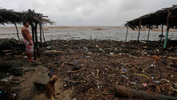
Zeker negentien doden in Midden-Amerika door tropische storm Nate
Deze foto is niet meer beschikbaar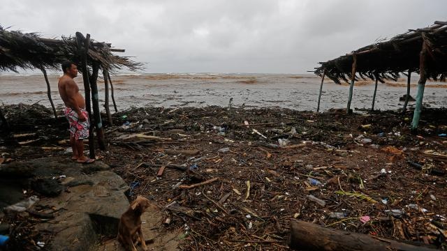
Foto:AFP
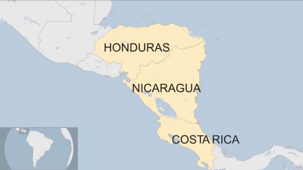
In Midden-Amerika zijn al zeker negentien doden gevallen als gevolg van de tropische storm Nate die over de regio trekt. Vooral Costa Rica en Nicaragua zijn getroffen.
In Costa Rica zijn zeker acht en in Nicaragua elf doden gevallen, vooral door overstromingen na hevige neerslag. Daarnaast worden nog tientallen mensen vermist. De Costa Ricaanse president Luis Guillermo Solis vertelde aan lokale media dat "er helaas nog veel meer slachtoffers zullen zijn.''
De storm trekt noordwaarts richting de regio Yucatan in Mexico en de zuidkust van de Verenigde Staten. Naar verwachting zwelt Nate zaterdag boven de Golf van Mexico verder aan tot een orkaan van categorie 1.
Voorspeld wordt dat de storm zondag de Amerikaanse zuidkust bereikt en voor zeker 250 millimeter neerslag zal zorgen.
Inwoners van de Amerikaanse staat Texas hebben van de autoriteiten de waarschuwing gekregen dat ze zich moeten voorbereiden op de storm.
Door: NU.nl/ANP
The hurricane models are in tremendous agreement by taking #Nate into SE Louisiana on Sunday. However, watch for minor shifts still. pic.twitter.com/gTc8lZvigX
— HurricaneTracker App (@hurrtrackerapp) 5 oktober 2017
The latest TS #Nate update shows a possible landfall as a Cat. 1 hurricane on SE LA Sunday at 7 AM. @WWLTV pic.twitter.com/Ck32uKqVcP
— Dave Nussbaum WWL-TV (@Dave_Nussbaum) 5 oktober 2017
#TropicalStorm Nate killed at least 20 people in #Nicaragua, #CostaRica and Honduras on Thursday, officials say https://t.co/D96jibbECn
— Breaking News (@newnewspage) 6 oktober 2017
¡Diario Costa Rica está disponible! https://t.co/HFIOiBkMrK Gracias a @lizethcastrotv @batallajose @anfivas #costarica #nate
— Costa Rica (@CostaRica) 6 oktober 2017
Storm Nate: At least 22 dead in Costa Rica, Nicaragua and Honduras
Deze foto is niet meer beschikbaar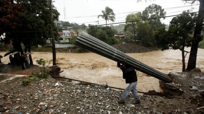
©Reuters, Heavy rain has swollen rivers and affected towns across Costa Rica
Tropical Storm Nate has killed at least 22 people in Costa Rica, Nicaragua and Honduras before it moves north towards the US.
A state of emergency has been declared in the Central American nations, where more than 20 people are missing.
It has caused heavy rains, landslides and floods which are blocking roads, destroying bridges and damaging houses.
In Costa Rica, nearly 400,000 people are without running water and thousands are sleeping in shelters.
At least eight people have died in the storm there, while another 11 were killed when it moved north and reached Nicaragua, where as much as 15ins (38cm) of rain had been predicted to fall by the US's National Hurricane Center.
Three people have been killed in Honduras, including two youths who drowned in a river, and several are reported missing.
Deze foto is niet meer beschikbaar
©Reuters, Some 5,000 people are sleeping in temporary shelters in Costa Rica
One man was also reportedly killed in a mudslide in El Salvador, according to emergency services.
In Costa Rica, all train journeys were suspended and dozens of flights cancelled on Thursday.
More than a dozen national parks popular with tourists have been closed as a precaution.
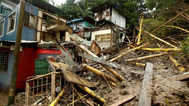
The storm also caused extensive damage to infrastructure in Nicaragua.
The country's vice-president Rosario Murillo advised people to be cautious in the heavy rains.
"Sometimes we think we think we can cross a river and the hardest thing to understand is that we must wait," he said on state radio.
"It's better to be late than not to get there at all."
Deze foto is niet meer beschikbaar
Nate was expected to move off the eastern coast of Honduras at 23:00 ET (03:00 GMT) on Thursday, according to the National Hurricane Center.
Forecasters say the storm will gain strength and become a category one hurricane before it makes landfall on the southern coast of the United States on Sunday.
Residents from Florida to Texas have been told to prepare for the storm, which, if it does strike, might be the third major storm to hit the southern coast his year.
Deze foto is niet meer beschikbaar
© AFP,Most of the damage in Nicaragua has been along its Caribbean coast
Both Texas and Florida are still recovering from the damage inflicted by Hurricane Harvey, which hit the former in August and caused "unprecedented damage", and Hurricane Irma, which made landfall in Florida in September.
A state of emergency was declared in 29 Florida counties, and in New Orleans in Louisiana.
The mayor of the city told people who live on low-lying ground to evacuate.
"There is no need to panic," Mitch Landrieu tweeted. "Be ready and prepare. Get a plan. Prepare to protect your personal property."
Oil companies operating in the Gulf of Mexico says they are evacuating staff from platforms which lie along the predicted path of the storm.
Bron: http://www.bbc.com/news/world-latin-america-41520672
Nate takes aim at Mexico, US after dousing Central America: #Nate #CentralAmerica #Msxico #Louisiana #US https://t.co/Yr45qnho4d (from @AP) pic.twitter.com/D4ZaD0RTSw
— Michael Conti (@ImperioMundial) 6 oktober 2017
La tempête tropicale #Nate a tué au moins 20 personnes entre #CostaRica, #Nicaragua et #Honduras. Vidéo au Nicaragua via Alerta Roja. pic.twitter.com/aWzoG80AW7
— Keraunos (@KeraunosObs) 6 oktober 2017
Moist! Arrived in #costarica just in time for the tropical storm. pic.twitter.com/tmJSjFS6Li
— danscape (@danscaper) 6 oktober 2017
La tormenta tropical #Nate ha obligado a las personas a autoevacuarse, ante las inundacioneshttps://t.co/h3PUia1yAb pic.twitter.com/se46gMJkub
— El Nuevo Diario (@elnuevodiario) 5 oktober 2017
NASA Finds Heavy Rainfall in Developing Tropical Storm Nate
After tropical depression 16 formed in the southwestern Caribbean Sea it continued organizing and strengthening. The Global Precipitation Measurement mission or GPM core satellite flew over the depression and found heavy rainfall. As the depression strengthened into Tropical Storm Nate, that heavy rainfall is expected to occur over a wide area, including locations well away from the center along the Pacific coast of Central America through Friday night, Oct. 6.

On Oct. 5, the GPM core satellite showed storm tops within powerful convective storms located in rain bands in the northeastern semicircle of TD16 were reaching heights of 9.3 mile (15 km).
Credits: NASA/JAXA, Hal Pierce
The National Hurricane Center forecast on Oct. 5 calls for Nicaragua to receive from 15 to 20 inches, isolated 30 inches; Costa Rica and Panama is forecast to receive 5 to 10 inches, isolated 20 inches; Honduras and Eastern portions of the Yucatan Peninsula from 4 to 8 inches, isolated 12 inches; and Belize between 2 to 5 inches, with isolated totals of 8 inches.
The GPM core observatory satellite passed above Tropical Depression 16 (forming tropical storm Nate) on Oct. 5, 2017 at 5:46 a.m. EDT (0946 UTC). At that time, Tropical Depression 16 (TD16) was located in the western Caribbean near the coast of Nicaragua with winds of about 34.5 mph (30 knots). Data received by GPM's Microwave Imager (GMI) and Dual-Frequency Precipitation Radar (DPR) showed bands of rain producing heavy rainfall East of TD16's center of circulation. Downpours in the Caribbean Sea East of Nicaragua were measured by GPM's Radar (DPR Ku Band) dropping rain at a rate of over 6.4 inches (162 mm) per hour.
At NASA's Goddard Space Flight Center in Greenbelt, Maryland a close-up 3-D cross section view (looking toward the southeast) was created that showed rainfall structure near TD16's center. It was created using data that was captured when the GPM satellite's radar (DPR Ku band) scanned precipitation in the center of the tropical cyclone. Storm tops within powerful convective storms located in rain bands in the northeastern semicircle of TD16 were shown by DPR reaching heights of 9.3 mile (15 km). GPM is co-managed by NASA and the Japan Aerospace Exploration Agency.
On Oct. 5 the GPM core satellite found some of Tropical Depression 16's thunderstorms located over the Caribbean Sea East of Nicaragua were dropping rain at a rate of over 6.4 inches (162 mm) per hour. GPM showed storm tops within powerful convective storms located in rain bands in the northeastern semicircle of TD16 were reaching heights of 9.3 mile (15 km).
Credits: NASA/JAXA, Hal Pierce
At 11 a.m. EDT on Oct. 5, the Government of Mexico issued a Tropical Storm Warning for the coast of the Yucatan Peninsula and the adjacent islands from Punta Herrero to Rio Lagartos. A Tropical Storm Warning is in effect for Sandy Bay Sirpi Nicaragua to Punta Castilla Honduras and from Punta Herrero to Rio Lagartos Mexico. A Hurricane Watch is in effect for Punta Herrero to Rio Lagartos Mexico.
At 11 a.m. EDT (1500 UTC), the center of Tropical Storm Nate was located inland over northeastern Nicaragua near 14.3 degrees north latitude and 83.7 degrees west longitude. That's about 30 miles (45 km) northwest of Puerto Cabezas, Nicaragua and about 65 miles (105 km south of Puerto Lempira, Honduras.
Nate was moving toward the northwest near 9 mph (15 kph). NHC said a turn toward the north-northwest at a faster forward speed is expected later today, with that motion continuing through Friday night. On the forecast track, the center of Nate should move across northeastern Nicaragua and eastern Honduras today and then over the northwestern Caribbean Sea tonight and Friday. The center is expected to approach the coast of the Yucatan Peninsula late Friday.
Maximum sustained winds are near 40 mph (65 kph) with higher gusts. Little change in strength is expected today while the center is over land. Strengthening is likely once the center moves over the northwestern Caribbean Sea tonight and Friday, Oct. 6.
The estimated minimum central pressure is 999 millibars. The National Hurricane Center (NHC) indicates that the tropical cyclone's future intensity is uncertain over the next couple days due to interaction with the coasts of Nicaragua, Honduras and then the Yucatan Peninsula.
The tropical cyclone is forecast to strengthen as it moves over the Gulf of Mexico and could threaten the northern Gulf Coast as a category one hurricane this weekend. A recent NHC forecast track indicated that the possible hurricane would most affect coastal areas from Louisiana through the Florida panhandle.
For forecast updates, visit the NHC website: www.nhc.noaa.gov.
Bron: https://www.nasa.gov/feature/goddard/2017/td16-southwestern-caribbean-ocean
Schwere Schäden und mindestens 22 Tote in Mittelamerika. Tropensturm #Nate könnte nun die USA treffen. pic.twitter.com/wsGr4XSQpX
— BR24 (@BR24) 6 oktober 2017
Tormenta tropical #Nate deja 22 muertos y cuantiosos daños materiales en Centroamérica https://t.co/82FlPVBykn pic.twitter.com/KdZb3wbAVp
— China Xinhua Español (@XHespanol) 6 oktober 2017
#LoQueSeVive Parte de las afectaciones en las vías principales de #Rivas provocadas por lluvias.https://t.co/55O9MQiwxe pic.twitter.com/8cCbvzYwtv
— Viva Nicaragua (@VivaNicaragua13) 5 oktober 2017
#Nate cuenta al menos 23 muertos y 27 desaparecidos en Centroaméricahttps://t.co/L3UjVZGIrK pic.twitter.com/uKVqDHy98R
— Cambio16 (@Cambio16) 6 oktober 2017
Au #CostaRica, les #pluies ont été diluviennes au passage de la #tempête tropicale #Nate, engendrant #inondations et glissements de terrains pic.twitter.com/XpCFtAM3mh
— Guillaume Woznica (@GWoznica) 6 oktober 2017
#StormNate rips through Central America killing 20 https://t.co/tqYSow0CJq pic.twitter.com/LQ3EjoAMyw
— Ruptly (@Ruptly) 6 oktober 2017
BP shutting all U.S. Gulf #oil and #gas production ahead of Tropical #Storm #Nate #Mexico #Louisiana #OOTT #OPEC https://t.co/cHq5fMEbVS pic.twitter.com/giU8QAGzs5
— Christopher Johnson (@chris1reuters) 6 oktober 2017
Tormenta tropical #Nate deja varios muertos en Centroaméricana https://t.co/wcK8giPoyw pic.twitter.com/mIvhQWsdkw
— teleSUR TV (@teleSURtv) 6 oktober 2017
Latest track from NHC for #Nate #ARWX pic.twitter.com/s1TRywkOdI
— Nathan Parker (@mallardnathan) 6 oktober 2017
La tormenta tropical '#Nate' deja 23 fallecidos a su paso por #Centroamérica pic.twitter.com/5vO8UrYzqk
— CIEM - Info y Emerg (@Cieminfo) 6 oktober 2017
فيضانات تجتاح أمريكا الوسطى وتقتل ٢٠ شخص على الأقل . العاصفة #Nate #كوستاريكا
— سلطان العويني (@aboleen777) 6 oktober 2017
pic.twitter.com/777l5NTaDV
#CentroAmérica: 23 muertos/27 desaparecidos tormenta #Nate #CostaRica #Nicaragua los más afectados.https://t.co/deu6LFeS9p vía @publico_es
— Ernesto Collazo (@ErnestoSuidry) 6 oktober 2017
Tropical storm #Nate flooding Nicaraguan #banana plantations pic.twitter.com/wYUI6gFiMD
— Targban (@Targban) 6 oktober 2017
Nate zwelt aan tot orkaan van categorie twee
Deze foto is niet meer beschikbaar
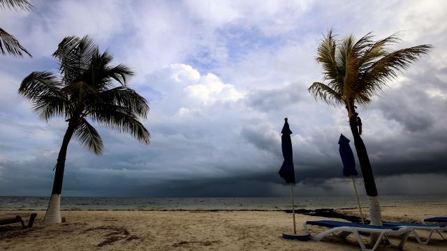
Foto:AFP
De tropische storm Nate is zaterdag verder in kracht toegenomen tot een orkaan van de laagste categorie en zal in de loop van zaterdagavond (lokale tijd) nog verder in kracht toenemen tot categorie 2. Dat komt neer op windsnelheden tot 175 kilometer per uur en grote kans op zware schade.
De depressie die nu boven de Golf van Mexico ligt, komt volgens Amerikaanse meteorologen van het Nationale Orkaancentrum zondagochtend vroeg aan land bij de plaats Biloxi, iets ten westen van de stad New Orleans.
Burgemeester Mitch Landrieu van New Orleans heeft inwoners van de stad gewaarschuwd voor uitval van stroom en kans op overstromingen. Er worden waterhoogtes verwacht die tussen 1,8 en 2,7 meter hoger zijn dan normaal. Inwoners die in de buurt wonen van zwakke dijken zijn al geëvacueerd.
In meerdere zuidelijke staten van de VS is de noodtoestand afgekondigd. De gouverneur van de staat Alabama, Kay Ivey, heeft inwoners in de kustgebieden opgeroepen om een veilig heenkomen te zoeken.
Gunstig
De storm trekt met een snelheid van 35 kilometer per uur noordwaarts, dat is relatief snel en mogelijk gunstig omdat deze dan minder schade kan aanrichten, zegt het Orkaancentrum.
Nate, die deze week al een spoor van vernieling in Centraal-Amerika aanrichtte, heeft daar zeker 25 levens geëist. Twaalf daarvan vielen in Nicaragua, negen in Costa Rica, twee in Honduras en twee in El Salvador. Duizenden mensen raakten dakloos en in meerdere landen is de noodtoestand afgekondigd.
Door: ANP
http://www.nu.nl | Gewijzigd: 7 oktober 2017, 19:08 uur, door Stefanv
Tropische storm Nate veroorzaakt flinke overstromingen in Mississippi
Deze foto is niet meer beschikbaarDeze foto is niet meer beschikbaar
Foto:AFP
De tropische storm Nate, die eerder nog ingeschaald werd als orkaan, is zondag aan land gegaan in de Amerikaanse staat Mississippi. In diverse steden heeft dit tot overstromingen geleid. Straten kwamen onder water te staan.
Nate kwam aan land in de monding van de rivier de Mississippi, niet ver van de stad New Orleans. De storm raast nu verder naar het noorden met een snelheid van bijna 40 kilometer per uur. Er worden windsnelheden gemeten van 140 kilometer per uur.
Nate was de vierde orkaan in twee maanden tijd die de VS treft. Eerder richtten Harvey, Irma en Maria grote verwoestingen aan in Texas, Florida en Puerto Rico.
In Centraal-Amerika, waar Nate in de afgelopen week als tropische storm overkwam, kwamen meer dan dertig mensen om het leven.
Noodtoestand
President Donald Trump heeft zaterdagavond de noodtoestand uitgeroepen in Mississippi vanwege Nate. Dit betekent dat de landelijke overheid alle noodhulp coördineert. Zo komt er extra hulp en geld vanuit de landelijke overheid.
Door: NU.nl/Reuters