Cycloon Kelvin zorgt voor problemen in Australië
Storm en wind

Cyclone Kelvin makes landfall with 'direct hit' at Anna Plains station south of Broome
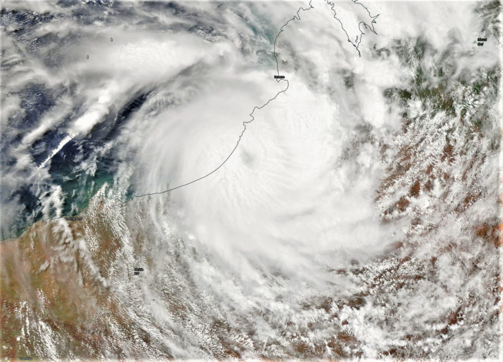
Bron afbeelding: Worldview
Ex-Tropical Cyclone Kelvin
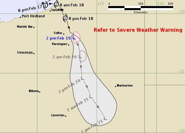
Bron afbeelding: Bureau of Meteorology
Lives and homes are under threat along part of northern Western Australian's coast after Tropical Cyclone Kelvin made landfall. A red alert was issued for people from Bidyadanga to Sandfire as the category two system crossed the coastline about 7:00am on Sunday, bringing wind gusts of up to 150 kilometres an hour and more heavy rainfall. The Department of Fire and Emergency Services (DFES) warned residents in the area were in danger and needed to act immediately. DFES said destructive winds would persist until at least mid-afternoon.

Bron afbeelding: David Stoate
Anna Plains Station, about 250km south of Broome, was left directly in the path of the cyclone. Station owner David Stoate said the eye of the storm passed over his property. "It has been a direct hit," he said. "Hopefully the damage isn't too bad we've just got to get through the next six hours or so. ''It got extremely windy about four o'clock in the morning and built up until about 6:30am when the eye appeared." Mr Stoate said the full extent of the damage would not be revealed until the system subsided. "I guess you've got to grateful it's a category two and not a category five," he said.
Residents at the Bidyadanga Aboriginal community also took shelter as the cyclone approached.
Community CEO Tania Baxter said locals had remained calm as conditions intensified. "The wind has picked up quite a lot in the last half an hour so it's pretty full on at the moment," she said. "We've all been waiting for it to happen for a few days now so I think everyone's ready for it."
Reports of 'significant flooding': BOM
The Bureau of Meteorology (BOM) said heavy rainfall had been recorded in the far western Kimberley and the far eastern Pilbara and was likely to continue throughout Sunday. In the 24 hours to 9:00am, 224 millimetres of rain was recorded at Wallal Downs, 167mm in the West Roebuck area and 153mm in Mandora. Broome recorded 96mm, taking the total for the month to 551mm — the wettest February since 1896 and the second-wettest on record. It also took the yearly total to 1467mm, only 30mm less than the highest annual total recorded in 2000.
The BOM's severe weather manager Brad Santos said the region had not escaped unscathed. "There's been reports of quite significant flooding through the western part of the Kimberley and the far eastern Pilbara," Mr Santos said. "We do have a number of flood watches and warnings current and we ask people to refer to the latest advice from the bureau and DFES." The deluge has forced the closure of parts of the Great Northern Highway.
A yellow cyclone alert remains in place for people between Broome and Bidyadanga but not including Broome, and between Sandfire and Wallal but not including Sandfire. DFES said the cyclone would only gradually weaken on Sunday night or during Monday morning as it continued to move inland. The system is predicted to track towards the eastern Goldfields by Wednesday morning.
Bron: ABC.au#cyclonekelvin 280mm so far very wet lucky to get away with no damage just flooding of the plains pic.twitter.com/SLLVvnWWjq
— Ben Mills (@Benomills) 18 februari 2018
CYCLONE KELVIN
— 7 News Perth (@7NewsPerth) 17 februari 2018
WA’s northwest is being impacted by Tropical Cyclone Kelvin. Reporter Jordan Cutts @CuttsJordan is on the North West Highway near Sandfire. #cyclonekelvin #7news pic.twitter.com/6xYLPrydXK
Australian motorist brave the surging waters from #CycloneKelvin. pic.twitter.com/xB0xOXayFI
— AccuWeather (@accuweather) 18 februari 2018
The well defined eye feature Tropical #CycloneKelvin developed after landfall stayed intact for quite some time. https://t.co/FrwE2tIaQe pic.twitter.com/aZOhAZQVnO
— Andrew Miskelly (@andrewmiskelly) 18 februari 2018
#KeepOnSmiling