
Tropical Storm Norbert could become a hurricane
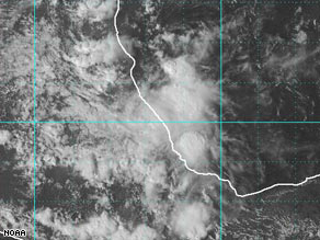
On Saturday, Tropical storm Norbert formed in the Pacific, and has continued to strengthen over the weekend. Forecasters at the National Hurricane Center expect it to become a hurricane over the next 24 hours, with the potential to bring heavy rain to and strong winds to southwest Mexico.

At present Norbert is 215 miles (345 kilometres) south of the popular tourist resort of Zihuatanejo, and will continue tracking towards Mexico’s south west coast. Norbert is currently packing winds of 60mph (95 kph), but has only brought sporadic rain to the southern state of Guerrero, home to Acapulco.
It has been an active Hurricane season so far this year, with Tropical Storm Marie continuing to linger out in the Pacific. As of Monday morning Marie is lying 845 miles (1360km) off the southern tip of the Baja Californian coast, but poses no threat to land, and is expected to weaken over the coming days.
©BBC/Weatherunderground
On Saturday, Tropical storm Norbert formed in the Pacific, and has continued to strengthen over the weekend. Forecasters at the National Hurricane Center expect it to become a hurricane over the next 24 hours, with the potential to bring heavy rain to and strong winds to southwest Mexico.
At present Norbert is 215 miles (345 kilometres) south of the popular tourist resort of Zihuatanejo, and will continue tracking towards Mexico’s south west coast. Norbert is currently packing winds of 60mph (95 kph), but has only brought sporadic rain to the southern state of Guerrero, home to Acapulco.
It has been an active Hurricane season so far this year, with Tropical Storm Marie continuing to linger out in the Pacific. As of Monday morning Marie is lying 845 miles (1360km) off the southern tip of the Baja Californian coast, but poses no threat to land, and is expected to weaken over the coming days.
©BBC/Weatherunderground
Tropical Storm Marco expected to hit Mexico
Story Highlights
# Tropical Storm Marco is packing 65 mph winds, forecasters say
# Mexican government issues hurricane watch, tropical storm warning
# Storm's center expected to be near Mexican coast late Monday or early Tuesday
# Forecasters say Marco could approach hurricane strength as it nears coast
Tropical Storm Marco continued its slow trek over the waters near Mexico's coast Monday and is expected to strike land late Monday or Tuesday morning, forecasters said. A tropical depression that formed Monday afternoon in the Gulf of Mexico strengthened hours later into Marco, the National Hurricane Center said. Mexican authorities issued a tropical storm warning from Cabo Rojo southward to Punta el Lagarto and posted a hurricane watch from Cabo Rojo southward to Veracruz.
Marco's maximum sustained winds were near 65 mph (100 km/hr) with higher gusts. "Some strengthening is forecast during the next 24 hours, and Marco could approach hurricane strength as it nears the coast," forecasters said. As of 8 p.m. ET, the center of Marco was about 80 miles (130 km) east-northeast of Veracruz, forecasters said. It was moving west-northwest at near 7 mph and was expected to continue doing so over the next day. "The center will be near the coast of Mexico, within the warning late tonight or early Tuesday," according to the hurricane center .
Tropical storm warnings mean tropical storm conditions, including maximum sustained winds of at least 39 mph, are expected within 24 hours. A hurricane watch means hurricane conditions, including minimum sustained winds of at least 74 mph, are possible within 24 hours. Marco was relatively small, however, with tropical storm-force winds extending up to 30 miles (48 km) from its center. The storm is expected to dump up to 4 inches of rain across the southern Mexican states of Veracruz, northern Oaxaca and Tabasco, with isolated amounts of up to 6 inches possible in some areas. The Atlantic hurricane season began on June 1 and ends on November 30.
Bron: CNN


Bron: Wunderground
Story Highlights
# Tropical Storm Marco is packing 65 mph winds, forecasters say
# Mexican government issues hurricane watch, tropical storm warning
# Storm's center expected to be near Mexican coast late Monday or early Tuesday
# Forecasters say Marco could approach hurricane strength as it nears coast
Tropical Storm Marco continued its slow trek over the waters near Mexico's coast Monday and is expected to strike land late Monday or Tuesday morning, forecasters said. A tropical depression that formed Monday afternoon in the Gulf of Mexico strengthened hours later into Marco, the National Hurricane Center said. Mexican authorities issued a tropical storm warning from Cabo Rojo southward to Punta el Lagarto and posted a hurricane watch from Cabo Rojo southward to Veracruz.
Marco's maximum sustained winds were near 65 mph (100 km/hr) with higher gusts. "Some strengthening is forecast during the next 24 hours, and Marco could approach hurricane strength as it nears the coast," forecasters said. As of 8 p.m. ET, the center of Marco was about 80 miles (130 km) east-northeast of Veracruz, forecasters said. It was moving west-northwest at near 7 mph and was expected to continue doing so over the next day. "The center will be near the coast of Mexico, within the warning late tonight or early Tuesday," according to the hurricane center .
Tropical storm warnings mean tropical storm conditions, including maximum sustained winds of at least 39 mph, are expected within 24 hours. A hurricane watch means hurricane conditions, including minimum sustained winds of at least 74 mph, are possible within 24 hours. Marco was relatively small, however, with tropical storm-force winds extending up to 30 miles (48 km) from its center. The storm is expected to dump up to 4 inches of rain across the southern Mexican states of Veracruz, northern Oaxaca and Tabasco, with isolated amounts of up to 6 inches possible in some areas. The Atlantic hurricane season began on June 1 and ends on November 30.
Bron: CNN
Bron: Wunderground
Every cloud has a silver lining
Norbert en Marco in Mexico
Mexico maakt zich op voor de komst van de storm Marco en de orkaan Norbert. Marco ligt al dicht bij de oostkust van Mexico. Norbert wordt van vrijdag op zaterdag verwacht op westkust aan wal te gaan.
Mexico maakt zich op voor de komst van een tweetal weersystemen. De eerste die verwacht wordt is Marco, momenteel een tropische storm. Deze bevindt zich in de Golf van Mexico en wordt verwacht vandaag nog aan wal te gaan. Dit zal naar verwachting in de buurt van de stad Tampico plaatsvinden. Volgens de laatste metingen zijn windsnelheden tot 102 km/u gemeten. Verwacht wordt dat dit niet veel meer zal worden dan ruim 110 km/u, waardoor Marco het niet weet te brengen tot volwaardige orkaan.

Norbert daarentegen heeft al windsnelheden bereikt van zo'n 120 km/u en is daarmee een categorie 1 orkaan, of hurricane. Norbert zal vrijdag het zuidelijk deel van Baja California bereiken en daarna richting het noordoosten trekken.


Norbert zal naar verwachting woensdag z'n toppunt bereiken. Er worden dan windsnelheden verwacht tot een kleine 150 km/u. Na het aan wal gaan zal Norbert in kracht afnemen en vanaf zondag zijn weg vervolgen als een tropische storm.

©Weeronline
Mexico maakt zich op voor de komst van de storm Marco en de orkaan Norbert. Marco ligt al dicht bij de oostkust van Mexico. Norbert wordt van vrijdag op zaterdag verwacht op westkust aan wal te gaan.
Mexico maakt zich op voor de komst van een tweetal weersystemen. De eerste die verwacht wordt is Marco, momenteel een tropische storm. Deze bevindt zich in de Golf van Mexico en wordt verwacht vandaag nog aan wal te gaan. Dit zal naar verwachting in de buurt van de stad Tampico plaatsvinden. Volgens de laatste metingen zijn windsnelheden tot 102 km/u gemeten. Verwacht wordt dat dit niet veel meer zal worden dan ruim 110 km/u, waardoor Marco het niet weet te brengen tot volwaardige orkaan.
Norbert daarentegen heeft al windsnelheden bereikt van zo'n 120 km/u en is daarmee een categorie 1 orkaan, of hurricane. Norbert zal vrijdag het zuidelijk deel van Baja California bereiken en daarna richting het noordoosten trekken.
Norbert zal naar verwachting woensdag z'n toppunt bereiken. Er worden dan windsnelheden verwacht tot een kleine 150 km/u. Na het aan wal gaan zal Norbert in kracht afnemen en vanaf zondag zijn weg vervolgen als een tropische storm.
©Weeronline
Bescheiden Marco
Tropische orkaan Marco trekt deze dinsdag de Mexicaanse kust op, een bijzonder exemplaar.
Met windsnelheden tippend aan orkaankracht is tropische storm Marco zeker geen verwaarloosbaar systeem. Integendeel. Bovendien valt er zoals altijd bij dergelijke tropische depressies veel regen. Wat Marco echter zo bijzonder maakt is zijn bescheiden omvang. Het systeem, zowel voor wat betreft het gebied met bewolking en regen, als de zone waarin het hard waait, is zeer klein.

Wat verder uitgezoomd, met de gehele Gol van Mexico zichtbaar. Marco is linksonder als kleine stip te zien.

Satellietbeeld van Marco, van dinsdagochtend vroeg lokale tijd.
De afgelopen weken
De meesten van ons zullen de flinke reeks van tropische stormen en orkanen nog wel herinneren, die het Caribische gebied en de Golf van Mexico in september troffen. Onder andere Gustav en Ike waren daarbij cyclonen die niet alleen zeer zwaar waren, maar ook bijzonder omvangrijk. In het geval van Ike was het stormveld zo groot als het gehele gebied tussen Amsterdam, Parijs, Geneve en Berlijn.

Afbeelding van Ike
Na de eerste weken van september werd het in het Caribische gebied en de Golf van Mexico een stuk rustiger, terwijl juist in Zuid- en Zuidoost-Azië een hausse aan soms zware tyfonen (de naam aldaar voor tropische orkanen) op gang kwam.
Marco
Marco is dus een stuk minder zwaar, maar tegelijkertijd niet te verwaarlozen. Naar verwachting van het Hurricane Center zal het systeem net voor het aan land komen in Mexico net aan tippen aan orkaankracht.

Het traject dat Marco naar verwachting aflegt.
Klein
Opvallend is hoe klein Marco is. Terwijl de 1-minuutgemiddelde windsnelheden nabij de kern in de buurt van 118 kilometer komen, met windstoten daarboven, is er op een afstaand van nog geen 20 kilometer van de kern zelfs geen sprake meer van stormkracht 9.

Het gebied waarin tot nu toe stormkracht is voorgekomen is klein.
Ter vergelijking (en puur hypothetisch): als Marco met de kern de Nederlandse kust bij Scheveningen zou optrekken, dan zouden daar dus windsnelheden voorkomen tot orkaankracht, 12 Beaufort, terwijl bij Noordwijk de wind niet sterker zou zijn dan stormachtig, kracht 8, of minder. Gekscherend kan je zeggen dat als je even met de wind mee fietst, je de storm alweer uit bent.
Bronnen: Hurricane Center, Meteo Consult
Tropische orkaan Marco trekt deze dinsdag de Mexicaanse kust op, een bijzonder exemplaar.
Met windsnelheden tippend aan orkaankracht is tropische storm Marco zeker geen verwaarloosbaar systeem. Integendeel. Bovendien valt er zoals altijd bij dergelijke tropische depressies veel regen. Wat Marco echter zo bijzonder maakt is zijn bescheiden omvang. Het systeem, zowel voor wat betreft het gebied met bewolking en regen, als de zone waarin het hard waait, is zeer klein.
Wat verder uitgezoomd, met de gehele Gol van Mexico zichtbaar. Marco is linksonder als kleine stip te zien.
Satellietbeeld van Marco, van dinsdagochtend vroeg lokale tijd.
De afgelopen weken
De meesten van ons zullen de flinke reeks van tropische stormen en orkanen nog wel herinneren, die het Caribische gebied en de Golf van Mexico in september troffen. Onder andere Gustav en Ike waren daarbij cyclonen die niet alleen zeer zwaar waren, maar ook bijzonder omvangrijk. In het geval van Ike was het stormveld zo groot als het gehele gebied tussen Amsterdam, Parijs, Geneve en Berlijn.
Afbeelding van Ike
Na de eerste weken van september werd het in het Caribische gebied en de Golf van Mexico een stuk rustiger, terwijl juist in Zuid- en Zuidoost-Azië een hausse aan soms zware tyfonen (de naam aldaar voor tropische orkanen) op gang kwam.
Marco
Marco is dus een stuk minder zwaar, maar tegelijkertijd niet te verwaarlozen. Naar verwachting van het Hurricane Center zal het systeem net voor het aan land komen in Mexico net aan tippen aan orkaankracht.
Het traject dat Marco naar verwachting aflegt.
Klein
Opvallend is hoe klein Marco is. Terwijl de 1-minuutgemiddelde windsnelheden nabij de kern in de buurt van 118 kilometer komen, met windstoten daarboven, is er op een afstaand van nog geen 20 kilometer van de kern zelfs geen sprake meer van stormkracht 9.
Het gebied waarin tot nu toe stormkracht is voorgekomen is klein.
Ter vergelijking (en puur hypothetisch): als Marco met de kern de Nederlandse kust bij Scheveningen zou optrekken, dan zouden daar dus windsnelheden voorkomen tot orkaankracht, 12 Beaufort, terwijl bij Noordwijk de wind niet sterker zou zijn dan stormachtig, kracht 8, of minder. Gekscherend kan je zeggen dat als je even met de wind mee fietst, je de storm alweer uit bent.
Bronnen: Hurricane Center, Meteo Consult
Norbert is Category 2 hurricane off Mexico's west coast
Hurricane Norbert has strengthened into a Category 2 hurricane and should continue to grow as it heads toward the Baja Peninsula, the National Hurricane Center in Miami, Florida, said late Tuesday night. Meanwhile, Tropical Storm Marco weakened to a tropical depression Tuesday, hours after making landfall over central Mexico's Gulf Coast.
Forecasters say they expect Norbert to become a major hurricane Wednesday. They expect Norbert to make landfall along the southern Baja Peninsula on Saturday, though hurricane forecasts are unpredictable and can change considerably.
At 11 p.m. ET Tuesday, Hurricane Norbert was about 500 miles (805 km) south of the southern tip of the Baja Peninsula, the hurricane center said. Its maximum sustained wind speeds had increased to 105 miles an hour. The hurricane formed Monday night.
As for Marco, the Mexican government had discontinued all watches and warnings for Marco by 5 p.m. ET. The storm made landfall Tuesday morning. Shortly before 5 p.m. ET, Marco's center was about 80 miles (129 kilometers) south-southeast of Tuxpan, Mexico, and about 75 miles (121 kilometers) northeast of Veracruz, the hurricane center said...More
©CNN
Hurricane Norbert Bears Down On Mexico
Hurricane Norbert strengthened Wednesday to a powerful Category 3 storm in the Pacific Ocean and was forecast to hit Mexico's Baja California peninsula by the weekend. The hurricane was expected to turn toward the northeast over the next two days on a path that could take it over the southern Baja peninsula and the Mexican mainland, the U.S. National Hurricane Center in Miami said.

Norbert's maximum sustained winds were near 125 mph, and it was expected to remain a hurricane for the next two days. The storm was centered about 460 miles south of the southern tip Baja California, and was moving west-northwest near 9 mph. Norbert is the seventh hurricane of the east Pacific season.
In Mexico's Gulf coast, Tropical Storm Marco weakened late Tuesday into a tropical depression after slamming into land with near hurricane-force winds. Mexico's state oil company had shutdown of some oil platforms in the gulf and evacuated some 3,000 people before Marco hit the coast about 55 miles north of Veracruz.
Marco was expected to dissipate overnight as it moved over Mexico's mountainous terrain, but forecasters said rains of up to 5 inches could still unleash mudslides. Marco appeared to have largely spared water-logged southern areas of Veracruz state, where rain-swollen rivers jumped their banks, leaving the towns of Minatitlan and Hidalgotitlan under 10 feet of water last week.
State authorities closed schools and set up some 200 shelters, while soldiers and rescue officials bused people from low-lying communities. In northern Veracruz state, authorities evacuated a hospital in the town of Misantla, where two overflowing rivers threatened to flood it.
©CBSnews
Hurricane Norbert strengthened Wednesday to a powerful Category 3 storm in the Pacific Ocean and was forecast to hit Mexico's Baja California peninsula by the weekend. The hurricane was expected to turn toward the northeast over the next two days on a path that could take it over the southern Baja peninsula and the Mexican mainland, the U.S. National Hurricane Center in Miami said.
Norbert's maximum sustained winds were near 125 mph, and it was expected to remain a hurricane for the next two days. The storm was centered about 460 miles south of the southern tip Baja California, and was moving west-northwest near 9 mph. Norbert is the seventh hurricane of the east Pacific season.
In Mexico's Gulf coast, Tropical Storm Marco weakened late Tuesday into a tropical depression after slamming into land with near hurricane-force winds. Mexico's state oil company had shutdown of some oil platforms in the gulf and evacuated some 3,000 people before Marco hit the coast about 55 miles north of Veracruz.
Marco was expected to dissipate overnight as it moved over Mexico's mountainous terrain, but forecasters said rains of up to 5 inches could still unleash mudslides. Marco appeared to have largely spared water-logged southern areas of Veracruz state, where rain-swollen rivers jumped their banks, leaving the towns of Minatitlan and Hidalgotitlan under 10 feet of water last week.
State authorities closed schools and set up some 200 shelters, while soldiers and rescue officials bused people from low-lying communities. In northern Veracruz state, authorities evacuated a hospital in the town of Misantla, where two overflowing rivers threatened to flood it.
©CBSnews
'Dangerous' hurricane Norbert nears Mexico
Hurricane Norbert has grown into a dangerous Category 4 hurricane with winds near 215 kph, as it churns towards Mexico's tourist destination of Baja, California, the National Hurricane Centre (NHC) says. Hurricane Norbert is already a Category 4 storm in the Saffir-Simpson scale, so we are under a green or precaution alert in southern Baja California, local state civil protection unit spokesman Jose Gajon said.

The NHC's five-day forecast showed Norbert, currently located in the Pacific Ocean about 715 kilometres south of Baja's southern tip, striking the peninsula at hurricane strength late Friday or early Saturday. Some fluctuations in intensity are possible during the next day or so ... followed by gradual weakening on Friday, the Miami-based NHC said.
Interests in the southern Baja California peninsula should monitor the progress of Norbert, the centre added. Southern Baja California includes the state capital of La Paz and the resort centres of Cabo San Lucas and San Jose del Cabo. The 1,100-kilometre-long peninsula in north-western Mexico abuts the US state of California and is mostly separated from mainland Mexico by the Gulf of California, also known as the Sea of Cortez.
Norbert is forecast to cross the peninsula, then head across mainland Mexico as it weakens and strike the US states of Texas, New Mexico and Arizona as a tropical depression.
©abc/weatherunderground
Hurricane Norbert has grown into a dangerous Category 4 hurricane with winds near 215 kph, as it churns towards Mexico's tourist destination of Baja, California, the National Hurricane Centre (NHC) says. Hurricane Norbert is already a Category 4 storm in the Saffir-Simpson scale, so we are under a green or precaution alert in southern Baja California, local state civil protection unit spokesman Jose Gajon said.
The NHC's five-day forecast showed Norbert, currently located in the Pacific Ocean about 715 kilometres south of Baja's southern tip, striking the peninsula at hurricane strength late Friday or early Saturday. Some fluctuations in intensity are possible during the next day or so ... followed by gradual weakening on Friday, the Miami-based NHC said.
Interests in the southern Baja California peninsula should monitor the progress of Norbert, the centre added. Southern Baja California includes the state capital of La Paz and the resort centres of Cabo San Lucas and San Jose del Cabo. The 1,100-kilometre-long peninsula in north-western Mexico abuts the US state of California and is mostly separated from mainland Mexico by the Gulf of California, also known as the Sea of Cortez.
Norbert is forecast to cross the peninsula, then head across mainland Mexico as it weakens and strike the US states of Texas, New Mexico and Arizona as a tropical depression.
©abc/weatherunderground
Hurricane Norbert weakens on approach to Baja
Hurricane Norbert weakened to a Category 3 storm early Thursday as it churned through the Pacific Ocean toward Mexico's Baja peninsula. Forecasters expect Norbert to make landfall along the southern end of Baja on Saturday, though hurricane forecasts can change considerably.
At 5 a.m. ET, Norbert was about 410 miles (660 kilometers) south-southwest of the southern tip of Baja California, according to the National Hurricane Center in Miami, Florida. The storm's maximum sustained wind speeds were about 125 miles an hour (205 kph).
Forecasters predict that Norbert will be a Category 2 storm when it makes landfall this weekend.
©CNN
Orkaan Norbert stevent langzaam op Mexico af

De krachtige orkaan Norbert boven de Stille Oceaan stevent langzaam op de Mexicaanse Westkust af. De wervelstorm staat voorlopig op niveau drie op een schaal van vijf. Dat deelde het Amerikaans orkaancentrum in Miami mee.
Het oog van de storm beweegt zich tegen elf kilometer per uur en bevindt zich ongeveer 550 kilometer ten zuidwesten van de zuidpunt van het schiereiland Baja California. De windsnelhden schommelden rond de 205 kilometer per uur.
©Hln
Hurricane Norbert Weakens To Category One
Hurricane Norbert has weakened to a Category One storm as it approaches Mexico's Baja, Calif., peninsula. The National Hurricane Center says the storm's maximum sustained winds have decreased to 90 mph. It is expected to continue to weaken as it turns toward land.

On Thursday afternoon, it was located 370 miles southwest of the southern tip of the peninsula. It is moving northwest at 5 mph. In the state of Baja California Sur, authorities canceled a weekend fishing contest in the coastal town of Todos Santos and changed the arrival dates in Los Cabos of two cruise ships.
Los Cabos Mayor Oscar Nunez late Wednesday urged residents living in makeshift housing and in low-lying areas to prepare to evacuate. Luis Gonzalez, the state's top civil protection official, said brigades are ready to begin evacuating residents of the towns of Agua Escondida, El Cardonal and Marquez de Leon on Norbert's potential path.
In Ciudad Obregon, across the Sea of Cortez from Baja California, farmers rushed to finish fertilizing their fields before the hurricane hit. Norbert will likely turn toward the northeast over the next two days en route to the Baja peninsula and the northwestern Mexican mainland, forecasters said.
©CBSnews
Hurricane Norbert has weakened to a Category One storm as it approaches Mexico's Baja, Calif., peninsula. The National Hurricane Center says the storm's maximum sustained winds have decreased to 90 mph. It is expected to continue to weaken as it turns toward land.
On Thursday afternoon, it was located 370 miles southwest of the southern tip of the peninsula. It is moving northwest at 5 mph. In the state of Baja California Sur, authorities canceled a weekend fishing contest in the coastal town of Todos Santos and changed the arrival dates in Los Cabos of two cruise ships.
Los Cabos Mayor Oscar Nunez late Wednesday urged residents living in makeshift housing and in low-lying areas to prepare to evacuate. Luis Gonzalez, the state's top civil protection official, said brigades are ready to begin evacuating residents of the towns of Agua Escondida, El Cardonal and Marquez de Leon on Norbert's potential path.
In Ciudad Obregon, across the Sea of Cortez from Baja California, farmers rushed to finish fertilizing their fields before the hurricane hit. Norbert will likely turn toward the northeast over the next two days en route to the Baja peninsula and the northwestern Mexican mainland, forecasters said.
©CBSnews
Norbert becomes Category 2 off Mexico
Hurricane Norbert regained strength Friday with 100 mph winds, becaming a Category 2 storm as it took aim at Mexico's Baja California Peninsula, forecasters said. On Friday morning it was centered in the Pacific Ocean 275 miles southwest of Baja's southern tip. It was moving north at 10 mph, officials with the U.S. National Hurricane Center said.

Forecasters predicted Norbert to weaken somewhat before hitting land. It was expected to plow into a relatively unpopulated stretch of coast north of the resort of Cabo San Lucas early Saturday. In the state of Baja California Sur, authorities canceled a weekend fishing contest in the coastal town of Todos Santos and changed the arrival dates in Los Cabos of two cruise ships.
Los Cabos Mayor Oscar Nunez late Wednesday urged residents living in makeshift housing and in low-lying areas to prepare to evacuate. Luis Gonzalez, the state's top civil protection official, said brigades are ready to begin evacuating residents of the towns of Agua Escondida, El Cardonal and Marquez de Leon on Norbert's potential path.
In Ciudad Obregon, across the Sea of Cortez from Baja California, farmers rushed to finish fertilizing their fields before the hurricane hit. Meanwhile, southeast of Norbert, Tropical Storm Odile's maximum sustained winds near 60 mph with strengthening expected. The storm was centered about 255 miles south of Acapulco, Mexico.
©MSNBC
Hurricane Norbert regained strength Friday with 100 mph winds, becaming a Category 2 storm as it took aim at Mexico's Baja California Peninsula, forecasters said. On Friday morning it was centered in the Pacific Ocean 275 miles southwest of Baja's southern tip. It was moving north at 10 mph, officials with the U.S. National Hurricane Center said.
Forecasters predicted Norbert to weaken somewhat before hitting land. It was expected to plow into a relatively unpopulated stretch of coast north of the resort of Cabo San Lucas early Saturday. In the state of Baja California Sur, authorities canceled a weekend fishing contest in the coastal town of Todos Santos and changed the arrival dates in Los Cabos of two cruise ships.
Los Cabos Mayor Oscar Nunez late Wednesday urged residents living in makeshift housing and in low-lying areas to prepare to evacuate. Luis Gonzalez, the state's top civil protection official, said brigades are ready to begin evacuating residents of the towns of Agua Escondida, El Cardonal and Marquez de Leon on Norbert's potential path.
In Ciudad Obregon, across the Sea of Cortez from Baja California, farmers rushed to finish fertilizing their fields before the hurricane hit. Meanwhile, southeast of Norbert, Tropical Storm Odile's maximum sustained winds near 60 mph with strengthening expected. The storm was centered about 255 miles south of Acapulco, Mexico.
©MSNBC
Hurricane Norbert strengthens, heads for Mexico
Hurricane Norbert has regained power as a Category 2 storm in the Pacific, churning toward Mexico's Baja California peninsula and forcing hundreds of people to flee to shelters.
Norbert was packing maximum sustained winds of 160 km per hour and was due to make landfall near the city of La Paz on Saturday (local time), missing a direct hit on the beach resort of Los Cabos, a popular destination for US tourists, according to the US National Hurricane Centre.
Rescue authorities began evacuating people from low-lying areas on the western side of the peninsula, which is not home to oil installations, as the first rains lashed the coast.
"This is now upon us, we expect the worst on Saturday morning," said Jose Gajon, head of the Baja California Sur civil protection agency.
Fisherman in La Paz hauled their boats out of the water and tourists checked out of seafront hotels to head further north, while businesses and offices taped and boarded up windows.
One of the main grocery chains in the peninsula began handing out flyers for customers telling people to stock up on water, tuna, bread and canned chillies.
"I'm doing a lot of praying," said Gibson Lewis, a tourist from Washington in the US, as he tied up his boat at the marina.
Others appeared relaxed. "The tourists are going to be hiding in their hotels, but the locals know. We have a culture here about hurricanes; we're used to it," said Ricky Lieras, a La Paz resident.
At Los Cabos the beaches were deserted and honeymooners stayed indoors.
After crossing the peninsula, Norbert could pummel into the agricultural states of Sonora and Sinaloa early on Sunday with heavy rains, but was not expected to cause any damage to mining interests in northern Mexico.
Meanwhile Tropical Storm Odile, south of Norbert in the Pacific, strengthened on Friday, threatening to dump rain on parts of Guatemala and southern Mexico, putting the region at risk of flash floods and mudslides.
Odile's winds reached nearly 95 km per hour and it is forecast to become a hurricane soon.
ABCNews
Geweld voor de kust van Mexico
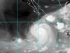
Al meerdere malen kwam een orkaan in het Caribische gebied in het nieuws. Maar ook aan de westkant van de Verenigde Staten kan het flink spoken. Norbert is daar nu als orkaan actief en ook de tropische storm Odile lijkt uit te groeien tot een orkaan.
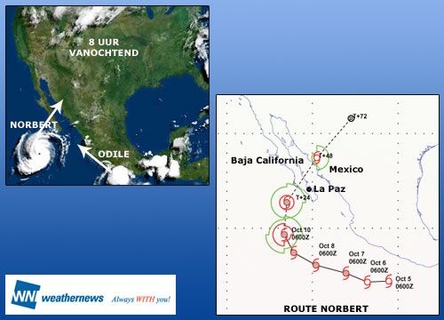
Op de satellietbeelden zijn beide systemen goed te herkennen. Het onbewolkte oog van Norbert duidt erop dat het een volledig ontwikkeld exemplaar is. Vanochtend werden windsnelheden gemeten van ruim 120 km per uur.
Odile is zich nog aan het ontwikkelen. Het ziet ernaar uit dat zij voorlopig dicht onder de Mexicaanse kust blijft en zondag het orkaanstadium bereikt, dat is windkracht 12.
Norbert stevent inmiddels af op het schiereiland Baja California. Morgen neemt de wind rond het systeem iets af en later op de dag trekt hij als een zeer zware storm, windkracht 11, ten noorden van La Paz het land op.
Daar zal hij aan activiteit verliezen en na passage van de Golf van California komt hij in Mexico aan als een tropische storm, windkracht 8. Vervolgens gaat de wind er boven land rap uit. Hieronder is de positie van beide systemen vanochtend vroeg te zien en bovendien de verwachte koers van Norbert.
©Weathernews
Al meerdere malen kwam een orkaan in het Caribische gebied in het nieuws. Maar ook aan de westkant van de Verenigde Staten kan het flink spoken. Norbert is daar nu als orkaan actief en ook de tropische storm Odile lijkt uit te groeien tot een orkaan.
Op de satellietbeelden zijn beide systemen goed te herkennen. Het onbewolkte oog van Norbert duidt erop dat het een volledig ontwikkeld exemplaar is. Vanochtend werden windsnelheden gemeten van ruim 120 km per uur.
Odile is zich nog aan het ontwikkelen. Het ziet ernaar uit dat zij voorlopig dicht onder de Mexicaanse kust blijft en zondag het orkaanstadium bereikt, dat is windkracht 12.
Norbert stevent inmiddels af op het schiereiland Baja California. Morgen neemt de wind rond het systeem iets af en later op de dag trekt hij als een zeer zware storm, windkracht 11, ten noorden van La Paz het land op.
Daar zal hij aan activiteit verliezen en na passage van de Golf van California komt hij in Mexico aan als een tropische storm, windkracht 8. Vervolgens gaat de wind er boven land rap uit. Hieronder is de positie van beide systemen vanochtend vroeg te zien en bovendien de verwachte koers van Norbert.
©Weathernews
Aanzienlijke schade door orkaan Norbert in Mexico
Orkaan Norbert, inmiddels verworden tot een wervelstrom van categorie twee op een schaal van vijf, is aan de westkust van Mexico gearriveerd en heeft op het schiereiland Baja California aanzienlijke schade aangericht. Bij windsnelheden van meer dan 200 kilometer per uur werden daken afgerukt en braken elektriciteitspalen af. Hevige regenval zette straten en huizen onder water. Een duizendtal mensen zijn naar noodverblijven gevlucht.
Norbert zal over de Zee van Cortez verder trekken richting noordoosten en vermoedelijk in afgezwakte vorm als orkaan van categorie één het Mexicaanse vasteland bereiken. Aan de zuidkust van Mexico aan de Stille Oceaan woedt momenteel de tropische storm Odile met windsnelheden van 125 km/u en eveneens zware neerslag.
©Hln | Gewijzigd: 30 januari 2017, 10:22 uur, door Joyce.s
3,000 evacuated as hurricane smashes Mexico
Nearly 3,000 people have been evacuated to temporary shelters on Mexico's pacific coast after a powerful hurricane made landfall. Hurricane Norbert has brought heavy rain and winds of more than 160 kilometres an hour to the region of Baja, California.
Local director of civil protection Miguel Arevalos says the storm poses a serious risk to the area. In some of the neighbourhoods the water level is 50 centimetres high, he said. We're having problems because of the previous two storms, Julio and Lowell, which left the ground water logged and now we have very poor drainage.
©abc
Orkaan Norbert eist drie mensenlevens in Mexico

Bij de doortocht van orkaan Norbert in het noorden van Mexico zijn vandaag drie mensen om het leven gekomen. Dat heeft de Mexicaanse burgerbescherming gemeld. De doden vielen vielen in de staat Sonora, vlakbij de Amerikaanse grens.
De orkaan zwakte vandaag nog af tot een tropische storm.
Bron:HLN.Be | Gewijzigd: 30 januari 2017, 10:22 uur, door Joyce.s