
 Onweerskansen week 27

Een aantal gifjes van EC12Z.
Neerslag:
Loop van 11uur morgenochtend tot 02:00 in de nacht.

Cape:
Loop van 11:00 tot 03:00

Lifted index. Morgen na middernacht(02:00) wordt deze ook in het oosten positief en is onweer dus uitgesloten.
Loop van 11uur tot 02:00

Mijn verwachting: Vanuit het zuid-westen pittige onweersbuien. Deze verplaatsen zich over het westen van het land richting het noord-oosten. | Gewijzigd: 1 juli 2015, 20:45 uur, door Stefanv
Neerslag:
Loop van 11uur morgenochtend tot 02:00 in de nacht.
Cape:
Loop van 11:00 tot 03:00
Lifted index. Morgen na middernacht(02:00) wordt deze ook in het oosten positief en is onweer dus uitgesloten.
Loop van 11uur tot 02:00
Mijn verwachting: Vanuit het zuid-westen pittige onweersbuien. Deze verplaatsen zich over het westen van het land richting het noord-oosten. | Gewijzigd: 1 juli 2015, 20:45 uur, door Stefanv
De nieuwe Guidance van het KNMI:
NEERSLAG:
De CAPE donderdagmiddag/avond tussen de 1000 en 2000 J/kg en de schering is gering. Convergentie is de belangrijkste forcering. De convectiemodus is waarschijnlijk single cells/pulse storms opgelijnd in de vorm van de convergentielijn. Bij deze buien is ook onweer en hagel mogelijk.Harmonie berekent morgenavond een bui met .150 ontladingen. INDECS berekent hoge conditionele kansen (53% en kans op onweer eveneens 53%) op onweersbuien met veel ontladingen (100-200+) . Op de eerder genoemde convergentielijn is de meest waarschijnlijke plaats waar de buien tot ontwikkeling kunnen komen
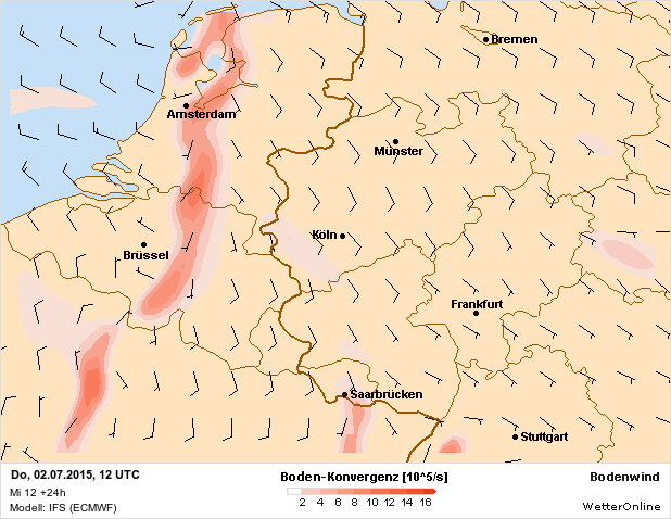 | Gewijzigd: 1 juli 2015, 20:50 uur, door Stefanv
NEERSLAG:
De CAPE donderdagmiddag/avond tussen de 1000 en 2000 J/kg en de schering is gering. Convergentie is de belangrijkste forcering. De convectiemodus is waarschijnlijk single cells/pulse storms opgelijnd in de vorm van de convergentielijn. Bij deze buien is ook onweer en hagel mogelijk.Harmonie berekent morgenavond een bui met .150 ontladingen. INDECS berekent hoge conditionele kansen (53% en kans op onweer eveneens 53%) op onweersbuien met veel ontladingen (100-200+) . Op de eerder genoemde convergentielijn is de meest waarschijnlijke plaats waar de buien tot ontwikkeling kunnen komen
| Gewijzigd: 1 juli 2015, 20:50 uur, door Stefanv

Citaat van jenssweerts, woensdag 1 juli 2015, 20:51 uur Ik begrijp eerlijk gezegd echt niet hoe dat het knmi bij lage shear waarden komt, de deep layer shear bedraagt een dikke 20 m/s en de SHR piekt naar waarden tot 500. Echt vreemd dat ze blijven volhouden dat er nauwelijks shear is.
Voor de zoveelste keer die werken met Ec die is in Ec lager dan Gfs en Wrf en daar werken ze niet mee.
Zie hier een lap tekst>>> http://www.onweer-online.nl/forum/topic/42567/onweerskansen-week-27/457736/#message457738
.
En hier nog eens : http://www.onweer-online.nl/forum/topic/42567/onweerskansen-week-27/457736/#message457742
KMI eveneens....die komen morgen echt wel op tijd met waarschuwingen mischien later straks nog wel. Ook even de vraag boven beantwoord!! | Gewijzigd: 1 juli 2015, 20:57 uur, door Tatanka
Voor de zoveelste keer die werken met Ec die is in Ec lager dan Gfs en Wrf en daar werken ze niet mee.
Zie hier een lap tekst>>> http://www.onweer-online.nl/forum/topic/42567/onweerskansen-week-27/457736/#message457738
.
En hier nog eens : http://www.onweer-online.nl/forum/topic/42567/onweerskansen-week-27/457736/#message457742
KMI eveneens....die komen morgen echt wel op tijd met waarschuwingen mischien later straks nog wel. Ook even de vraag boven beantwoord!! | Gewijzigd: 1 juli 2015, 20:57 uur, door Tatanka
there can be only one
Citaat van Tatanka, woensdag 1 juli 2015, 20:53 uur
KMI eveneens....die komen morgen echt wel op tijd met waarschuwingen mischien later straks nog wel. Ook even de vraag boven beantwoord!! Misschien met de update van 22u?
KMI eveneens....die komen morgen echt wel op tijd met waarschuwingen mischien later straks nog wel. Ook even de vraag boven beantwoord!! Misschien met de update van 22u?
Onweersdagen 2019: 19
Tropische dagen 2019: 13 (warmste dag: 25 juli 2019 met 41,5°C)
---
Onweersdagen 2020: -
Tropische dagen 2020: -
Hoogste temperatuur 2020: -
Tropische dagen 2019: 13 (warmste dag: 25 juli 2019 met 41,5°C)
---
Onweersdagen 2020: -
Tropische dagen 2020: -
Hoogste temperatuur 2020: -

Aardig wat verschillen in de modellen. GFS en WRF laten leuke waardes zien. EC minder waardoor de KNMI guidance ook onzeker is, maar alsnog berekenen ze onweersbuien. De waardes bij WRF en GFS moeten we zekers niet negeren wat Tatanka al vaker zei! Harmonie berekent centraal en noord onweersbuien en WRF ziet het alleen voor het westen zitten. Kortom. Morgen vooral nowcasten waar de buien zullen ontstaan, want nu valt er niet veel te zeggen waar ze exact kunnen ontstaan.
Mochten ze ontstaan kunnen ze fel uitpakken. Veel CAPE aanwezig en vooral aan de westkant van de vore veel schering aanwezig (volgens WRF en GFS) Supercells mogelijk. Vooral, omdat de waardes dit aardig laten zien. Harmonie berekent ook zware windstoten tijdens buien en GFS ziet enkele hagelstenen tot 6 cm tot de mogelijkheid. In korte tijd kan er veel neerslag vallen en is de bliksemfrequentie aardig hoog (100-200+ ontladingen) alhoewel dit het meest bovenin zal gebeuren... (hoogte onweer)
Onweerskansen aankomende week niet te missen. Elke dag kans op wat onweer. Na het weekend zien de modellen nieuwe mogelijkheden op onweersbuien, maar laten we eerst afwachten wat ons morgenavond en vrijdagnacht staat te verwachten.

Bron: http://www.art-of-thunders.nl/weer/waarschuwingen/professionele-weerkaarten/onweerskansen/
Mochten ze ontstaan kunnen ze fel uitpakken. Veel CAPE aanwezig en vooral aan de westkant van de vore veel schering aanwezig (volgens WRF en GFS) Supercells mogelijk. Vooral, omdat de waardes dit aardig laten zien. Harmonie berekent ook zware windstoten tijdens buien en GFS ziet enkele hagelstenen tot 6 cm tot de mogelijkheid. In korte tijd kan er veel neerslag vallen en is de bliksemfrequentie aardig hoog (100-200+ ontladingen) alhoewel dit het meest bovenin zal gebeuren... (hoogte onweer)
Onweerskansen aankomende week niet te missen. Elke dag kans op wat onweer. Na het weekend zien de modellen nieuwe mogelijkheden op onweersbuien, maar laten we eerst afwachten wat ons morgenavond en vrijdagnacht staat te verwachten.
Bron: http://www.art-of-thunders.nl/weer/waarschuwingen/professionele-weerkaarten/onweerskansen/
Stormchaser bij @Art_of_thunders.
Site: http://www.art-of-thunders.nl
Twitter: @LeonEikenaar
Site: http://www.art-of-thunders.nl
Twitter: @LeonEikenaar

Ondertussen in Engeland.. dit toch wel indrukwekkende radarbeeld.. voorbode voor wat ons te wachten staat? lijkt me een supercell en ook iets van een hook zichtbaar nu.


Berichten samengevoegd door Stefanv | Gewijzigd: 2 juli 2015, 00:55 uur, door Frl86
Berichten samengevoegd door Stefanv | Gewijzigd: 2 juli 2015, 00:55 uur, door Frl86

Storm Forecast
Valid: Thu 02 Jul 2015 06:00 to Fri 03 Jul 2015 06:00 UTC
Issued: Wed 01 Jul 2015 22:56
Forecaster: GATZEN
A level 2 was issued for NW France and N / central Benelux countries mainly for large hail and severe wind gusts and to a lesser extend tornadoes and excessive precipitation.
A level 1 was issued for the southern North Sea, southern Scandinavia, W Germany, central and western France, E Spain, and the Alps mainly for large or very large hail, severe wind gusts, and excessive precipitation.
A level 1 was issued for W Turkey mainly for large hail.
SYNOPSIS
An amplified ridge is located across western Europe, flanked by a deep N Atlantic trough and a trough/cut off across E Europe. A strong southerly jet extends from Iberia to the North Sea ahead of a lifting trough that will travel from the Bay of Biscay to the North Sea during the period.
At lower levels, a plume of warm air extends from the west Mediterranean to the North Sea. To the west, a sharp frontal zone will slowly progress east over France and the North Sea. Eastern Europe is affected by a northerly to easterly flow advecting dry and cooler air. Best low-level moisture will be co-located with the axis of warm air where it nicely overlaps with steep lapse rates. Focus of convective development will be a frontal convergence that slowly moves east.
estofex.org
Berichten samengevoegd door justinos | Gewijzigd: 2 juli 2015, 01:09 uur, door Justin
En het Extended forecast voor vrijdag op zaterdag is er inmiddels ook uit.... wordt nog leuk...

Extended Forecast
Valid: Fri 03 Jul 2015 06:00 to Sat 04 Jul 2015 06:00 UTC
Issued: Wed 01 Jul 2015 23:10
Forecaster: GROENEMEIJER
A level 2 was issued for NW France and W Belgium
This extended forecast is issued to highlight an elevated potential of severe weather over NW France and W Belgium on Friday evening. There is a risk of strong tornadoes and very large hail.
Other areas are not discussed.
DISCUSSION
An eastward progression on Thursday of the warmest lower tropospheric air and the moist convergence zone on its western fringe across the Benelux and France is followed by a westward advection of low-level moisture on Friday.
This advection in concert with surface pressure falls over the Bay of Biscay in association with the northward advection of extremely warm air over France and an approaching mid-level trough over the eastern North Atlantic ocean. Within the noist air-mass, CAPE may rise over 2000 J/kg per GFS and around 1000 J/kg per ECMWF.
Near a warm frontal zone over the Channel, high amounts of storm-relative helicity (~400 m2/s2) and high low-level shear (10-15 m/s) are forecast. NWP guidance hints that, during a time window in the evening, substantial surface-based CAPE and the strong low-level shear may overlap.
There is some uncertainty about the question if storms will develop in this region and somewhat dry forecast profile. GFS shows the strongest precipitation signals.
Any storms developing in that shear environment have a high probability of turning into supercells with a risk of very large hail and of (strong) tornadoes.
Bron: http://www.estofex.org
Extended Forecast
Valid: Fri 03 Jul 2015 06:00 to Sat 04 Jul 2015 06:00 UTC
Issued: Wed 01 Jul 2015 23:10
Forecaster: GROENEMEIJER
A level 2 was issued for NW France and W Belgium
This extended forecast is issued to highlight an elevated potential of severe weather over NW France and W Belgium on Friday evening. There is a risk of strong tornadoes and very large hail.
Other areas are not discussed.
DISCUSSION
An eastward progression on Thursday of the warmest lower tropospheric air and the moist convergence zone on its western fringe across the Benelux and France is followed by a westward advection of low-level moisture on Friday.
This advection in concert with surface pressure falls over the Bay of Biscay in association with the northward advection of extremely warm air over France and an approaching mid-level trough over the eastern North Atlantic ocean. Within the noist air-mass, CAPE may rise over 2000 J/kg per GFS and around 1000 J/kg per ECMWF.
Near a warm frontal zone over the Channel, high amounts of storm-relative helicity (~400 m2/s2) and high low-level shear (10-15 m/s) are forecast. NWP guidance hints that, during a time window in the evening, substantial surface-based CAPE and the strong low-level shear may overlap.
There is some uncertainty about the question if storms will develop in this region and somewhat dry forecast profile. GFS shows the strongest precipitation signals.
Any storms developing in that shear environment have a high probability of turning into supercells with a risk of very large hail and of (strong) tornadoes.
Bron: http://www.estofex.org
Regen, das gewoon vloeibare zonneschijn