
Tropical Storm Warning Issued for Florida

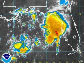
A tropical storm warning was issued Sunday for parts of Florida as a newly formed depression swirled about 90 miles off the coast. The warning was issued for areas east of the Alabama state line to the Suwanee River. The warning means tropical storm conditions are likely within the next 24 hours.
Forecasters at the National Hurricane Center said the depression was expected to be near Florida's northern Gulf Coast by Sunday afternoon. It was moving to the north-northwest at about 16 mph, with maximum sustained winds around 35 mph. It was about 90 miles from Tampa early Sunday morning.
Bron: Foxnews | Gewijzigd: 16 augustus 2009, 18:49 uur, door Marga
Every cloud has a silver lining
Tropical Storm Claudette bears down on Florida
Story Highlights
# Tropical depression strengthens to tropical storm status, forecasters say
# The storm, which formed overnight, is expected to hit land by Sunday evening
A tropical depression churning toward the Florida Panhandle on Sunday picked up strength to become Tropical Storm Claudette, the National Hurricane Center said. The depression's surface winds reached 40 mph shortly after noon ET, raising it to tropical storm status, the center said. At 11 a.m. ET, the center of the storm was about 75 miles south-southeast of Apalachicola, Florida, and about 200 miles from Pensacola, the center said. It was moving at about 14 mph, putting it on course to hit land by Sunday evening. Tropical storm warnings were in effect from the Alabama-Florida border east to the Suwannee River. A tropical storm warning means that weather conditions will deteriorate in the next 24 hours. The storm could bring 3 to 5 inches of rain, with isolated amounts up to 10 inches, and storm surges across portions of North Florida.
Bron: CNN
Every cloud has a silver lining
UPDATE: Tropical Storm Claudette bears down on Florida
Tropical Storm Claudette was on course late Sunday afternoon to hit the Florida Panhandle in the evening, and the storm's outer rain bands already were pushing into the area. At 5 p.m. ET, the center of Claudette, with maximum sustained winds near 50 mph, was in the Gulf of Mexico about 40 miles west-southwest of Apalachicola, Florida, and about 120 miles southeast of Pensacola, the National Hurricane Center said. It was moving northwest at about 14 mph.
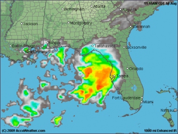
A tropical storm warning was in effect from the Alabama-Florida border east to the Suwannee River. A tropical storm warning means tropical storm conditions are expected in the warning area in the next 24 hours. The storm could bring 3 to 6 inches of rain, with isolated amounts up to 10 inches, across portions of the Florida Panhandle, central and southern Alabama and extreme southwestern Georgia. Storm surges and isolated tornadoes also were possible across portions of North Florida.
©CNN, Accuweather | Gewijzigd: 17 augustus 2009, 01:43 uur, door talkyr86
Tropical Storm Claudette was on course late Sunday afternoon to hit the Florida Panhandle in the evening, and the storm's outer rain bands already were pushing into the area. At 5 p.m. ET, the center of Claudette, with maximum sustained winds near 50 mph, was in the Gulf of Mexico about 40 miles west-southwest of Apalachicola, Florida, and about 120 miles southeast of Pensacola, the National Hurricane Center said. It was moving northwest at about 14 mph.
A tropical storm warning was in effect from the Alabama-Florida border east to the Suwannee River. A tropical storm warning means tropical storm conditions are expected in the warning area in the next 24 hours. The storm could bring 3 to 6 inches of rain, with isolated amounts up to 10 inches, across portions of the Florida Panhandle, central and southern Alabama and extreme southwestern Georgia. Storm surges and isolated tornadoes also were possible across portions of North Florida.
©CNN, Accuweather | Gewijzigd: 17 augustus 2009, 01:43 uur, door talkyr86
Claudette makes landfall on Florida Panhandle
The storm hit near the eastern end of Santa Rosa Island, just southeast of Fort Walton Beach in Florida, about 1:15 a.m. ET, the National Weather Service said. Claudette is expected to move through the Panhandle and into southern Alabama, CNN meteorologist Jacqui Jeras said. Even before Claudette made landfall, the storm's outer bands pounded the area with heavy rain, with officials warning that some coastal areas had the potential for localized flooding.
"What we're just mainly asking is residents to stay off the roads tonight, and if you do approach a flooded area on a roadway, turn around," said John Cherry, spokesman for the Florida Division of Emergency Management. iReport.com: Are you in Claudette's path? The storm could bring 3 to 6 inches of rain, with isolated amounts up to 10 inches, across portions of the Florida Panhandle, central and southern Alabama and extreme southwestern Georgia. Storm surges and isolated tornadoes also were possible across portions of North Florida.
©CNN | Gewijzigd: 27 januari 2017, 12:32 uur, door Joyce.s
Tropische Storm Claudette
Afgelopen weekend is boven de oostelijke Golf van Mexico het derde tropische systeem ontstaan. Ze groeide uit tot Tropische Storm en kreeg de naam Claudette. Claudette kent slechts een korte levensduur. Ze ontstond uit een omvangrijk onweerscomplex boven het oosten van de Golf van Mexico en bereikte op 16 augustus de status Tropische Storm.
Vandaag (17 augustus) gaat ze aan land in het noordwesten van Florida tussen Pensacola en Panama City. Dit gebeurt met windsnelheden van zo'n 80 km/u en veel regen. Voor het einde van de dag zal ze de status van Tropische Storm verliezen.
Bron: NOAA/WeerOnline
Birth of Tropical Storm Claudette Forecast Well Ahead
Tropical Rainstorm Claudette is moving northward on track for the Tennessee and Ohio Valleys at midweek. The system made landfall as a moderate tropical storm near Fort Walton Beach, Fla. early Monday morning. The storm formed in a forewarned area of concern, first tipped off to AccuWeather.com readers last week by Expert Joe Bastardi. Additionally, last week, AccuWeather.com readers were first warned of the possibility of three simultaneous systems in the Atlantic for early this week: Ana, Bill and Claudette.

Tornadoes
So Far, one death is attributed to Claudette. A young man drowned at Panama City Beach, Fla. late Sunday afternoon. Isolated flash flooding and locally gusty thunderstorms will be the legacy of Claudette, northward from the central and eastern Gulf of Mexico coasts to part of the Ohio Valley into Wednesday. In a couple of incidents, the strongest thunderstorms can spawn a tornado. An anticipated tornado outbreak over the Midwest Wednesday, will not be associated with Claudette's remnants.
Steamy air
In addition to the heavy downpours, Claudette is also bringing very humid, tropical air into the Gulf Coast. The steamy air will continue to surge northward, reaching the lower Ohio Valley by Tuesday but staying west of the Appalachians. This high humidity will make afternoon temperatures feel about 10 degrees warmer than what they actually are. The only relief will be in the form of thunderstorms. Farther east, from the Carolinas to Georgia, it will be a hot day with plenty of sunshine, but the humidity will not all that high, making the day at least a little more tolerable.
Bron: Accuweather | Gewijzigd: 18 augustus 2009, 08:30 uur, door Marga
Tropical Rainstorm Claudette is moving northward on track for the Tennessee and Ohio Valleys at midweek. The system made landfall as a moderate tropical storm near Fort Walton Beach, Fla. early Monday morning. The storm formed in a forewarned area of concern, first tipped off to AccuWeather.com readers last week by Expert Joe Bastardi. Additionally, last week, AccuWeather.com readers were first warned of the possibility of three simultaneous systems in the Atlantic for early this week: Ana, Bill and Claudette.
Tornadoes
So Far, one death is attributed to Claudette. A young man drowned at Panama City Beach, Fla. late Sunday afternoon. Isolated flash flooding and locally gusty thunderstorms will be the legacy of Claudette, northward from the central and eastern Gulf of Mexico coasts to part of the Ohio Valley into Wednesday. In a couple of incidents, the strongest thunderstorms can spawn a tornado. An anticipated tornado outbreak over the Midwest Wednesday, will not be associated with Claudette's remnants.
Steamy air
In addition to the heavy downpours, Claudette is also bringing very humid, tropical air into the Gulf Coast. The steamy air will continue to surge northward, reaching the lower Ohio Valley by Tuesday but staying west of the Appalachians. This high humidity will make afternoon temperatures feel about 10 degrees warmer than what they actually are. The only relief will be in the form of thunderstorms. Farther east, from the Carolinas to Georgia, it will be a hot day with plenty of sunshine, but the humidity will not all that high, making the day at least a little more tolerable.
Bron: Accuweather | Gewijzigd: 18 augustus 2009, 08:30 uur, door Marga
Every cloud has a silver lining
Claudette Weakens

Tropical Storm Claudette has weakened into a tropical depression approximately 15 miles north-northwest of Brewton, Ala. It made landfall near Fort Walton Beach, Fla., early Monday morning. As of 8:00 a.m. EDT Monday, Claudette was located near 31.3 north and 87.2 west with a central pressure of 1011 millibars or 29.85 inches. Heavy, but very localized, flooding rainfall will be the biggest concern from this tropical depression, but there can also be minor wind damage, especially north and east of where the center of circulation tracks. Claudette will continue to weaken over land on Monday as it moves into the Deep South. Flooding rain will still be likely along the path of Claudette across the Deep South into Monday night. All tropical storm warnings have been allowed to expire.
Bron: Accuweather
Every cloud has a silver lining