
 Onweerskansen van 1,2,3 en 4 september

marcel`westland
Lid
Woonplaats: Honselersdijk (Zuid-Holland)
Berichten: 1483
Lid sinds: 26 aug. 2009

Het felle weerlichten is zo goed als gestopt, maar het was wel een mooi schouwspel. Erg jammer dat de buien zich beperken tot de kustgebieden, maar wel mooi dat het op zo'n grote afstand te zien is!
Nou kijken wat de buien gaan doen, de eerste valt iig uit elkaar, weet niet wat de buien bij Den Haag gaan doen..
Die buien zie ik inmiddels ook al flitsen!
Nou kijken wat de buien gaan doen, de eerste valt iig uit elkaar, weet niet wat de buien bij Den Haag gaan doen..
Die buien zie ik inmiddels ook al flitsen!
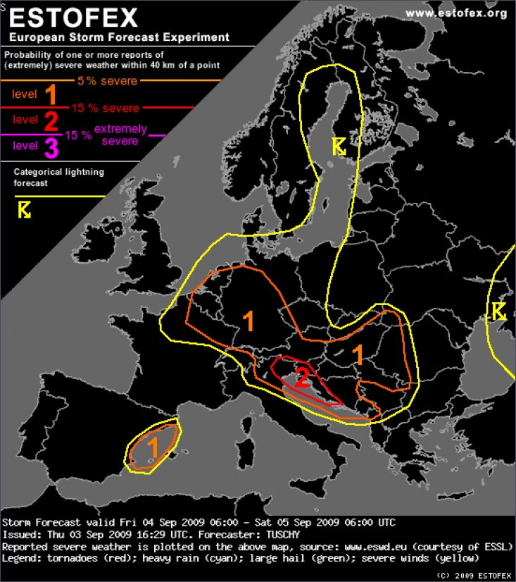
A level 1 was issued for parts of Germany, Netherlands, Belgium, Luxembourg and Switzerland, parts of Austria, Hungary, E-Slovakia, W-Ukraine, W-Romania and most parts of the Balkans mainly for large hail and severe wind gusts.
DISCUSSION: Belgium, the Netherlands, Luxembourg, eastern France and Germany
The main story during the forecast is the passage of the trough axis and attendant pool of cold mid-level air and the passage of a wave at lower levels (in high gear below 3km). Both features are displaced in time by a few hours, so thunderstorms are forecast in numerous waves and at different places.
The wave is placed over eastern France (roughly 9 UTC), over southern Germany at 12-15 UTC and over the Czech Republic at 18 UTC (based on GFS with ECMWF a tad slower). Both models show potential for thunderstorms, probably deep with cool EML temperatures in GFS. Initiation will be probably bound to the eastward moving cold front with isolated showers/thunderstorms in the weakly capped prefrontal warm sector. A potential scenario is an active, eastward racing cold front with embedded thunderstorms. Degree of shear especially at low levels points to an organized line (LEWP) with a severe wind gust threat. This line ought to decrease in intensity over N-Austria and the Czech Republic during the late evening hours, as CAPE decreases. Timing of this wave is important in respect of how unstable the airmass will be, which finally affects the magnitude of the wind gust risk. Next to that dominant risk, isolated tornadoes and marginal hail can't be ruled out, given degree of shear and some LL CAPE release.
Another area of interst includes Belgium, the Netherlands, Luxembourg and most parts of Germany during the daytime hours. As cold mid-levels overspread those areas from the west, steep lapse rates and adequate surface moisture result in at least modest CAPE release (up to 500 J/kg MLCAPE). Shear decreases gradually to the north, but remains supportive for organized thunderstorms with a hail and wind gust risk. An isolated tornado risk is present due to some directional shear and low LCLs, but the overall risk remains low as directional shear component first increases as CAPE decreases (evening and night hours). Thunderstorms decay after sunset.
Thunderstorm coverage is on the increase over the Baltic Sea during the night hours, as cold thermal trough overspreads the warmer Sea. Moderate CAPE with abundant LL CAPE release but weak shear point to an isolated waterspout risk, althoug no convergence zone can be seen in the models, which could serve as a focus for enhanced spout chances.
The same for the southern North Sea, where a few spouts are possible well in the night hours, although overall set-up does not look too promising with decreasing moisture content and no organized "convective lines" due to the late passage of a backbend occlusion (18-21 UTC).
©Estofex
Ik wilde net berichtgeven uit Leiden Noord.
Echt tekeer gaat het niet (tenminste, niet voor mijn maatstaven), maar het dondert wel redelijk door de laatste paar uur. Kleine buitjes, de ene is net voorbij en de volgende komt er alweer aan.
Zonet een prachtige CG die bijna loodrecht naar beneden ging - ik keek net de goede kant op. Heel dichtbij, geweldige knal!
Ook lichtende nachtwolken gezien, tussen de buien door - altijd leuk. Die volle maan half achter de wolken geeft ook sfeer.
De wind is wel erg apart zo af en toe. Ik woon in een flatgebouw en die horizontale regen is een fascinerend gezicht, hahaha!
Woon je verder ten noorden van Leiden, Jan? Ik meende zonet de brandweer met sirenes langs te zien rijden na een redelijk spectaculaire klap vanuit noordelijke richting. | Gewijzigd: 3 september 2009, 23:04 uur, door Wings of Death
Echt tekeer gaat het niet (tenminste, niet voor mijn maatstaven), maar het dondert wel redelijk door de laatste paar uur. Kleine buitjes, de ene is net voorbij en de volgende komt er alweer aan.
Zonet een prachtige CG die bijna loodrecht naar beneden ging - ik keek net de goede kant op. Heel dichtbij, geweldige knal!
Ook lichtende nachtwolken gezien, tussen de buien door - altijd leuk. Die volle maan half achter de wolken geeft ook sfeer.
De wind is wel erg apart zo af en toe. Ik woon in een flatgebouw en die horizontale regen is een fascinerend gezicht, hahaha!
Woon je verder ten noorden van Leiden, Jan? Ik meende zonet de brandweer met sirenes langs te zien rijden na een redelijk spectaculaire klap vanuit noordelijke richting. | Gewijzigd: 3 september 2009, 23:04 uur, door Wings of Death

Citaat van Verwijderde_gebruiker_01, donderdag 3 september 2009, 23:11 uur
Nee ik woon in midden/zuid waar nooit geen onweer is
Een tiental km van mij af denk ik, niet zo heel ver. Ik zie vaag soms weerlicht richting NW. Maar ik ga lekker pitten, misschien word ik wakker van het gebliksem, zo niet heb ik niks gehad want ik word er meestal wel wakker van
Een tiental km van mij af denk ik, niet zo heel ver. Ik zie vaag soms weerlicht richting NW. Maar ik ga lekker pitten, misschien word ik wakker van het gebliksem, zo niet heb ik niks gehad want ik word er meestal wel wakker van
Het leven als een onweersliefhebber is vergelijkbaar met het leven van een pornoacteur. Beide personen krijsen en kreunen bij hun liefhebberij!
Er zijn meer hondjes die Fikki heten!!
Ik woon in Warmond om precies te zijn. Niet ver bij de merenwijk vandaan dus, 5min fietsen ong. Er waren hier een aantal slagen redelijk dichtbij ja, geen sirenes gehoord. Maar 't was hier ook hard aan het stormen en gieten (ramen open voor foto's) dus kan zijn dat ik 't eea gemist heb. Ik zie op p2000.nl wel veel stormschade meldingen uit Hoofddorp en een brandje in Bennebroek, maar dat is te ver naar het noorden denk ik om sirenes uit Leiden te vragen.
Ik woon in Warmond om precies te zijn. Niet ver bij de merenwijk vandaan dus, 5min fietsen ong. Er waren hier een aantal slagen redelijk dichtbij ja, geen sirenes gehoord. Maar 't was hier ook hard aan het stormen en gieten (ramen open voor foto's) dus kan zijn dat ik 't eea gemist heb. Ik zie op p2000.nl wel veel stormschade meldingen uit Hoofddorp en een brandje in Bennebroek, maar dat is te ver naar het noorden denk ik om sirenes uit Leiden te vragen.
Morgen zeker de kans groter op onweer dus wacht af
vandaag paar flitsen verders wind en wat regen
vandaag paar flitsen verders wind en wat regen
Zie mijn hobby via de link
https://gurushots.com/Martijn.photography/photos
En deze pagina heb ik opgezet om mijn droom werkelijkheid te laten worden.
http://martijn-naar-de-usa.webnode.nl/voorwoord/
https://gurushots.com/Martijn.photography/photos
En deze pagina heb ik opgezet om mijn droom werkelijkheid te laten worden.
http://martijn-naar-de-usa.webnode.nl/voorwoord/
Ben net terug van een een chase ritje
Emmeloord - Lelystad - Almere - Amersfoort - Apeldoorn - Zwolle - Emmeloord. Tijdens het rijden zo nu en dan mooi onweer gezien, aantal CG's en natuurlijk diverse CC's. Echter het kwam slechts incidenteel en dan van alle kanten en daardoor voor mij (nog) niet te fotograferen. Heb op de A1 bij Amersfoort wel een paar filmpjes gemaakt, maar dat beperkte zich met name tot incidentele flitsen.
Onderweg voor Amersfoort trouwens pittige regen met daardoor eventjes 30km/u op de A27. Conclusie aantal leuke ontladingen gezien, echter foto technisch niets aan gehad. Mocht er nog iets moois op film staan dan post ik dat binnenkort nog.
Volgende keer beter.
edit: en dan hoor je dat relatief dicht bij huis op het traject Joure - Heerenveen e.o veel regen en bliksem is geweest | Gewijzigd: 4 september 2009, 01:20 uur, door PolderPS
Emmeloord - Lelystad - Almere - Amersfoort - Apeldoorn - Zwolle - Emmeloord. Tijdens het rijden zo nu en dan mooi onweer gezien, aantal CG's en natuurlijk diverse CC's. Echter het kwam slechts incidenteel en dan van alle kanten en daardoor voor mij (nog) niet te fotograferen. Heb op de A1 bij Amersfoort wel een paar filmpjes gemaakt, maar dat beperkte zich met name tot incidentele flitsen.
Onderweg voor Amersfoort trouwens pittige regen met daardoor eventjes 30km/u op de A27. Conclusie aantal leuke ontladingen gezien, echter foto technisch niets aan gehad. Mocht er nog iets moois op film staan dan post ik dat binnenkort nog.
Volgende keer beter.
edit: en dan hoor je dat relatief dicht bij huis op het traject Joure - Heerenveen e.o veel regen en bliksem is geweest | Gewijzigd: 4 september 2009, 01:20 uur, door PolderPS
Volg me ook op Twitter, want er is meer dan alleen onweer.
Heb vanaf een uur of 10 mooie CG's en CC's mogen aanschouwen richting Delft/Den Haag. (gezien vanuit Maassluis). Zaten pittige jongens tussen. Mijn vriendin heeft een mooie Canon spiegelreflex, alleen heb ik geen kaas gegeten van de techniek erachter. Moet maar snel in de leer....