
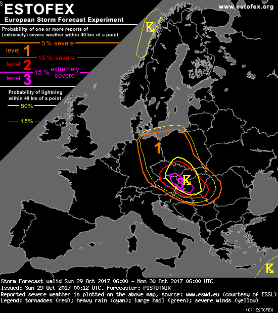
Storm Forecast
Valid: Sun 29 Oct 2017 06:00 to Mon 30 Oct 2017 06:00 UTC
Issued: Sun 29 Oct 2017 00:12
Forecaster: PISTOTNIK
Threat levels were issued for large parts of central Europe mainly for severe convective wind gusts and to a lesser extent for tornadoes.
SYNOPSIS
Amplified long waves govern the circulation in Europe. A 500 hPa trough over eastern Europe and a deep surface low with its center over Estonia are opposed by a 500 hPa ridge and an extensive surface high over western Europe and the near Atlantic.
In-between, a very strong NW-erly flow curves from Scandinavia across central Europe to the Aegean Sea. Embedded in this mid-level jet streak, a powerful short-wave trough ejects from Denmark (Sun 00 UTC) to the Black Sea (Mon 00 UTC) and reinforces the eastern European long-wave trough. Strong synoptic lift ahead of this short wave and in the jet's left exit also stimulates the formation of a secondary surface cyclone over the Skagerrak Sea Saturday night, which is expected to deepen below 970 hPa while it moves across Poland into Belarus on Sunday. This new cyclone will bring a remarkable autumn storm to central Europe, probably including a round of severe convection along its cold front.
DISCUSSION
... central Europe (cold front passage) ...
A tongue of moist air from the North Sea is advected eastward ahead of the cold front (2m dewpoints around 10°C across N Germany and around 12°C in the Netherlands at Sun 00 UTC, in line with the forecast models). It is overrun by steepening lapse rates, as the approaching short-wave trough lifts and vertically stretches the air. This interaction will likely create neutral to marginally unstable profiles up to 4-5 km height by early Sunday morning, and the formerly stratiform rain shield along the cold front is expected to break up into convective elements in E Germany and W Poland.
Vertical wind shear is more than supportive for storm organization below the mid-level jet streak: 0-3 km bulk shear increases from 10 m/s in central Poland to 30 m/s near the Alps, where 0-3 km storm-relative helicity also peaks above 400 m^2/s^2. The best overlap of all "ingredients" for organized convection is anticipated in the 06 to 14 UTC time frame, as the most active part of the cold front crosses east-central Europe. Linear convection with wind gusts very probably above 25 m/s and possibly, at least locally, above 33 m/s is expected to develop. Fine-meshed models agree on such a scenario.
The cold front will probably be located along a line Wroclaw (Poland) - Prague (Czech Republic) - Nuremberg (Germany) at Sun 06 UTC and will quickly move SE-ward. In the first few hours of this forecast period, the most active line segments with the highest risk of lightning and severe to localized extreme wind gusts will likely follow the Polish / Czech border. By mid-morning, the eastern line segments will gradually weaken and the most active parts should shift across the E and S Czech Republic into E Austria, W Slovakia, and finally Hungary, following the path of the strongest synoptic forcing.
The area to the east of the Alps becomes a particular focus. As the westerly flow increases ahead of the cold front, diurnal heating and westerly downslope winds (which may easily become severe themselves, but are not included into the ESTOFEX threat level scheme) may push the temperatures temporarily close to 20°C in the late morning. The deeper and drier boundary layer further increases the risk of severe downbursts as the convective line arrives. In addition, a pocket of westerly 850 hPa winds up to 40 m/s (!) overspreads this area exactly in the time frame when the cold front is expected to arrive - e.g., around 10 UTC in Vienna and Bratislava, 11 UTC in Budapest and 13 UTC at the Hungarian / Serbian / Croatian border triangle.
All in all, the setup appears menacing enough to issue a confined level 3 area. Prior to the cold front's arrival, the formation of a "dryline" boundary between poorly mixed, more humid air to the east and warmer, drier Foehn subsidence to the west should be monitored! If it appears, it would mark a preferred path for the axis of the most extreme wind gusts.
Convection will gradually weaken in Croatia, Serbia and W Romania in the late afternoon, as both the strong wind field and the synoptic lift start to disintegrate.

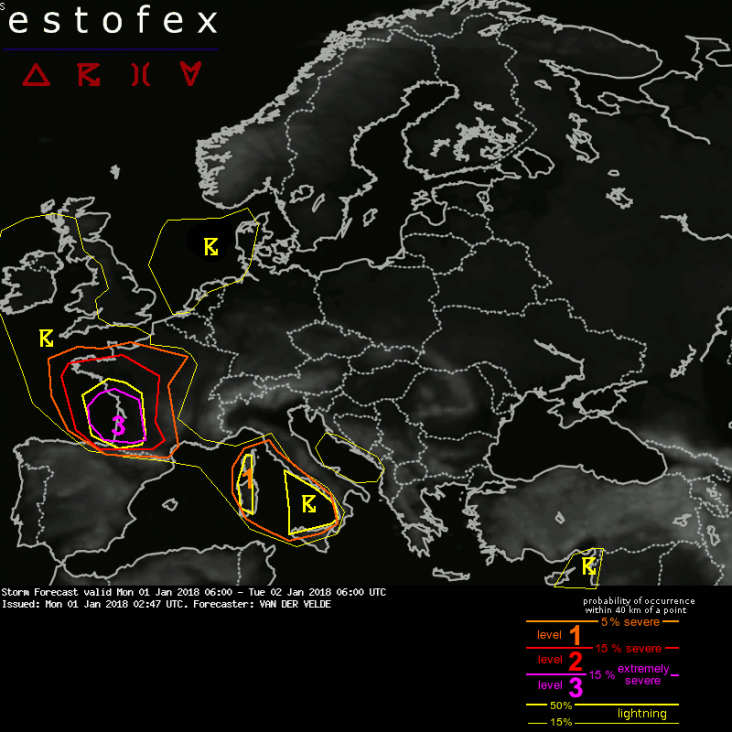
Storm Forecast
Valid: Mon 01 Jan 2018 06:00 to Tue 02 Jan 2018 06:00 UTC
Issued: Mon 01 Jan 2018 02:47
Forecaster: VAN DER VELDE
A level 3 was issued across southwestern France mainly for extremely severe convective wind gusts and tornado probabilities.
A level 2 was issued across western and central France, as well as the north coast of Spain, mainly for severe convective wind gusts and tornado probabilities.
A level 1 was issued across western Mediterranean and Tyrrhenian Sea mainly for severe convective wind gusts.
SYNOPSIS
A large low pressure system with the core over western Norway remains in place over northwestern Europe. An activating satellite low pressure system tracks from the Atlantic south of Ireland through the English Channel towards Belgium and on to eastern Germany. Strong non-convective winds are forecast across northern France and southern Germany. However, the passage of its cold front from Bay of Biscay into southwestern France meets all criteria for severe convective weather. Cold upper air advection combined with 6-7 g/kg BL mixing ratio over the Celtic Sea has caused steep lapse rates and a few hundred J/kg CAPE, while models draw a sharp cold front with strong low-level convergence and differential theta-e advection, supported by a strong PV anomaly.
DISCUSSION
...France...
The cold front will likely trigger a line echo wave pattern (LEWP) with bowing line segments responsible for wind gusts of 30-35 m/s as is present in the 1-3 km layer. 0-1 km shear vectors over 15 m/s (locally even 20 m/s) magnitude will be in place across N Spain and most of France, supporting tornadogenesis as well as the bow echoes. Convection is likely to survive even inland as strong moisture advection, dynamic destabilization factors, lapse rates and orographic lifting are carried as far as central France.
As the front moves on, its structure may be torn apart between Pyrenees and Alps after 15Z, by the cut-off of moisture supply, but convection will likely recover before Corsica and Sardinia around 21Z, while the flow weakens.
Estofex.org
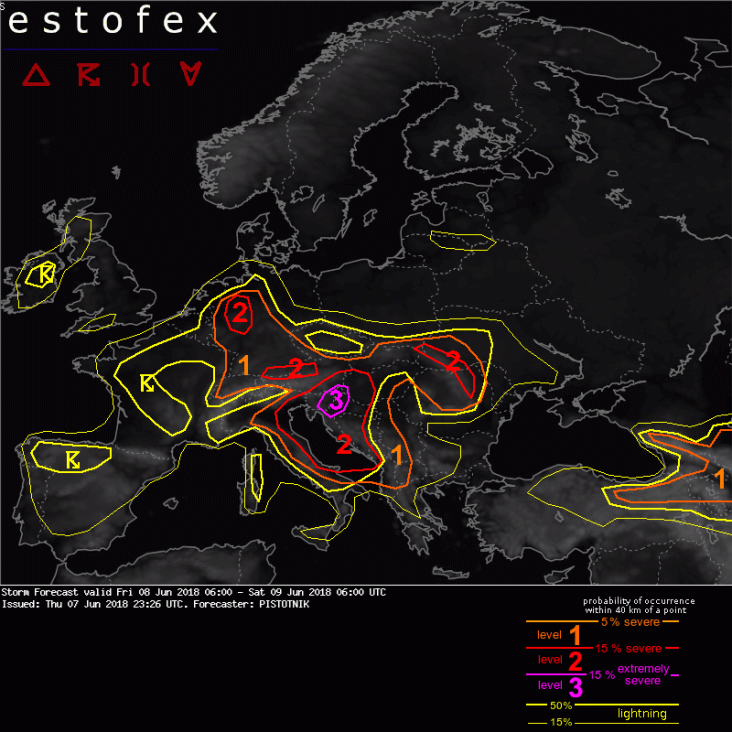
Storm Forecast
Valid: Fri 08 Jun 2018 06:00 to Sat 09 Jun 2018 06:00 UTC
Issued: Thu 07 Jun 2018 23:26
Forecaster: PISTOTNIK
A level 3 is issued for Slovenia and N Croatia mainly for large hail and severe convective wind gusts.
A level 1 and level 2 are issued for N and E Italy, SE Austria, SW Hungary and Croatia mainly for large hail, severe convective wind gusts and excessive convective precipitation.
A level 2 is issued for the Adriatic Sea mainly for tornadoes and to a lesser degree large hail and severe convective wind gusts.
A level 1 and level 2 are issued for Bosnia-Herzegovina, Montenegro, parts of Serbia and Albania mainly for large hail and to a lesser degree severe convective wind gusts and excessive convective precipitation.
Level 1 and level 2 areas are issued for S Germany, N Austria, Slovakia, S-ernmost Poland, NE Hungary, Romania and the SW Ukraine as well as for NE Turkey, parts of Georgia, Armenia and the Russian Caucasus region mainly for large hail and excessive convective precipitation, and to a lesser degree severe convective wind gusts.
A level 1 and level 2 are issued from NW Germany into Switzerland mainly for excessive convective precipitation and to a lesser degree large hail.
SYNOPSIS
Another deepening polar trough and a surface cold front translate from Finland into W Russia. Otherwise, mostly weak pressure gradients remain in place across much of Europe. Cut-off lows at 500 hPa are located NW of Scotland, NW of Iberia and over central Italy.
Warm and moist air covers much of the continent south of England, S Norway and the Ukraine. It often allows moderate CAPE in reponse to daytime heating, mostly under weak vertical wind shear and weak dynamics. However, a confined window for an outbreak of organized storms opens up ahead of the Italian cut-off low, where particularly hot air wedges from SE Europe towards Austria and increasingly overlaps with enhanced vertical wind shear.
... Italian E coast, Adriatic Sea, Croatia, Slovenia, SE Austria, SW Hungary, Bosnia-Herzegovina, Serbia, Montenegro, Albania ...
Steep lapse rates, originally created over the Sahara desert and reinforced over the Appennines and the Dinaric mountains, spread over the area of interest. With 2m dewpoints of 16-20C over the Pannonian plains and up to 23C over the Adriatic Sea, around 2000 J/kg of CAPE are predicted to build on Friday, locally even more. Warm air advection will create a pronounced cap, but lift ahead of the cut-off low will start to increase from the SW as the day proceeds. At the same time, vertical wind shear rises to 15 m/s (20 m/s) across the lowest 3 (6) km under slightly veering profiles.
Scattered convection will likely still be left over from the previous night over N and E Italy or will form already before noon, aided by increasing synoptic lift and a mess of outflow boundaries and other disturbances of the low-level wind field. Competition and destructive interference may lower the severe weather risk somewhat, but at least scattered large hail, severe wind and heavy rain events are expected with this activity. Tail-end storms towards the southeast may organize best into supercells.
It is worth mentioning that the majority of the model pool, including convection-permitting models like WRF and MOLOCH, predict scattered activity across the northern and central Adriatic Sea throughout the forecast period. Scirocco winds would advect a very moist boundary layer with enhanced 0-1 km shear into these storms, which would very likely become supercellular. If such a high storm coverage over the Adriatic Sea indeed verifies, numerous tornadoes could form, most of them well off the coastlines, though.
In the evening and overnight, clustering storms will increasingly move onshore or form anew in coastal Croatia, Montenegro and Albania with a gradually decreasing but still enhanced risk of all kinds of severe weather.
Further north and east of the Adriatic Sea, it is most difficult to assess where and when the cap will be broken. Convective initiation will stay isolated at best until mid-afternoon. Possible sites for solitary early "cap breakers" are the southern Alps (if upvalley flow is strong enough) or outflow boundaries, laid out by several storm clusters from the previous night that are moving northward in E Austria and W Hungary near the nose of the warm air advection regime at the time of writing (Thu 22 UTC). Despite an expected struggle against the cap, these early storms, if they form, may already organize well and bring large hail.
In the course of the afternoon, the probability of convective initiation rapidly increases over the Dinaric mountains in W Slovenia and NW Croatia. While vertical mixing will keep both CAPE and wind shear lower in these initiating regions, storms will quickly intensify and organize as soon as they tap into the abundant CAPE reservoir and better shear further northeast. Convection-resolving models agree on quick upscale growth into a large MCS with a most likely track across much of Slovenia in the evening, including the bordering regions of Croatia and Austria. Supercells will likely bring large to very large hail in initiating stages or generally at the southern flank of such a system. In addition, a tornado is not ruled out, though this risk is mitigated by not too low cloud bases and rather inconspcuous low-level shear. Along the MCS's main body, severe straight-line winds will betimes become the main risk. They may become quite widespread and include some extreme events (>32 m/s).
The mature and finally slowly weakening MCS could persist well into the night or even into the next morning while it continues its track northeastward into E Austria, Hungary and possibly even Slovakia. It will likely bring a prolonged period of heavy rain, and flash floods become another dangerous hazard in the course of the night, especially in S and E Austria where soils are often already saturated. In addition, severe wind gusts or large hail are still possible at the leading edge or under more discrete updrafts, respectively.
Similarly abundant CAPE and enhanced vertical wind shear is expected over the eastern parts of Croatia and Bosnia-Herzegovina as well as in Serbia, but the capping inversion will be stronger towards the south (indicated by the Thu 12 UTC Trapani, Pratica di Mare and Brindisi soundings) and synoptic lift arrives later and stays weaker. It is uncertain whether the cap can be broken at all. However, every storm that forms over the Dinaric mountains and descends into the Pannonian plain can easily become supercellular with a risk of large to very large hail. Severe downbursts and flash floods become additional hazards in case convection manages to grow upscale. In that case, it may also persist into the evening and night. | Gewijzigd: 8 juni 2018, 19:05 uur, door Lako
13 Oktober 2018
Storm Forecast
Valid: Sat 13 Oct 2018 06:00 to Sun 14 Oct 2018 06:00 UTC
Issued: Fri 12 Oct 2018 23:45
Forecaster: BEYER
A level 3 was issued for parts of Portugal surrounded by a level 2 covering also parts of Spain mainly for severe to damaging wind gusts and to a lesser extent for (strong) tornados and excessive precipitation.
A level 2 was issued for parts of Sicily and Malta for excessive precipitation.
A level 1 was issued for parts of Turkey and Cyprus for excessive precipitation.
SYNOPSIS
A strong and widespread upper level high is influencing large parts of the forecast domain with stable conditions. South of the high-pressure system two separated upper-level lows can be found over the Mediterranean Sea - one close to Turkey and the other over Southern Italy and Sicily.
Over the near North Atlantic Ocean, a strongly amplified and broad trough is active, leading to that southerly /southwesterly flow over most parts of Europe and thus to unusually warm temperatures over most parts of Europe. On the forward flank of the trough, several surface lows have traveled northeastward brought mostly non-convective severe wind gusts to parts of the British Isles. On Saturday another low is influencing that area that however is much weaker.
The most interest on that day is hurricane Leslie that is quickly traveling eastward and will probably reach the Iberian Peninsula during the night from Saturday to Sunday posing a high risk for severe and damaging wind gusts.
DISCUSSION
...Iberian Peninsula...
Hurricane Leslie is rapidly approaching Portugal and will likely bring severe to damaging wind gusts during the night hours of Sunday
Looking at the current satellite images Leslie still looks well organized with a symmetric cloud shield and cloud top temperatures of almost -70 degree C. The central pressure is estimated to be around 971 hPa.
At the moment Leslie can be found to the south of the upper-level trough. It is forecasted that it should be taken up by the trough in the upcoming hours leading to a further acceleration of its movement to the east and also leading to a beginning transition into an extratropical system during the forecast period. However, models keep Leslie as a system with a tropical appearance for a long time when approaching the Iberian peninsula. It is also forecasted that the system should stay rather strong until it will make landfall. Although increasing shear and somewhat lower SSTs should normally weaken Leslie, the interaction with the through is probably the reason why its central pressure is forecasted to not rise significantly or even drop again during the night time.
The symmetrical appearance will probably disappear in the evening hours due to the aforementioned transition process. Models forecast the strongest pressure gradient to the south and to the west of Leslie. Together with the movement speed of Leslie, the regions of the southern flank of Leslie should see the strongest gusts but with that strong gradient west of the core, the whole coastline can be affected by severe wind gusts. Winds in 925 hPa are forecasted up to 50 m/s.
Ensemble forecasts show a significant probability of wind gusts in the excess of 30 m/s in the aforementioned area. Depending on the model damaging wind gust higher than 40 m/s are well possible. A few solutions also show more than 50 m/s. The risk of severe wind gusts can also affect parts of Western and Northwestern Spain although the storm is significantly weakening more inland.
There are still uncertainties in the exact track of Leslie and in the strength it makes landfall. ICON and ECMWF are the models that show Leslie making landfall at hurricane strength on a northerly course from Lisboa to northeastern Portugal. GFS, however, has a much weaker storm that is also moving on a more southerly track. However, models are getting more and more confident concerning a strong landfall.
The time of the landfall is expected to take place at around midnight (MESZ).
Although it is rather questionable if convections (in form of lightning) may develop we decided to issue an LVL3 area for the wind risk that comes from a convectively driven system that is only slowly transforming into a low with extratropical character.
Besides the wind risk, a locally excessive precipitation threat exists since the system brings a lot of liquid water. However, models do only give little hints for higher amounts of precipitation which is probably due to the rather fast movement of Leslie and the orography of the affected area. But amounts of 30 to 80 mm in a short time frame may lead to local flash floods.
Strong low-level shear together with low LCL would lead to an enhanced threat for tornados that may also be strong. This risk is highest to the south of Leslie where also notable CAPE values of a few hundred J/kg can be expected along a developing cold front. Also, a nice maximum of moisture convergence traveling eastward can be found in the models. This is the reason why the LVL2 area was extended to the south.
There will be an update on Leslie during the day.
22 juni 2019
Storm Forecast
Valid: Sat 22 Jun 2019 06:00 to Sun 23 Jun 2019 06:00 UTC
Issued: Sat 22 Jun 2019 00:10
Forecaster: PISTOTNIK
A level 3 is issued for parts of Croatia mainly for large hail and to a lesser degree for severe convective wind gusts.
A level 3 is issued for a small area in NE Italy mainly for large hail and to a lesser degree for tornadoes and severe convective wind gusts.
A level 1 and level 2 are issued for N Italy, SE Austria, Slovenia, Hungary, parts of Croatia, Bosnia-Herzegovina, Serbia, Romania and Bulgaria mainly for large hail, excessive convective precipitation and to a lesser degree for severe convective wind gusts.
A level 1 and level 2 are issued for the rest of Austria, Germany and the S Czech Republic mainly for excessive convective precipitation.
A level 1 and level 2 are issued for Slovakia, SE Poland and the SW Ukraine, as well as for the W half of Turkey for excessive convective precipitation, large hail and to a lesser degree for severe convective wind gusts.
A level 1 is issued for parts of Belarus and NW Russia mainly for excessive convective precipitation and to a lesser degree for large hail, severe convective wind gusts and tornadoes.
A level 1 is issued for NE Turkey, Georgia and the Russian Caucasus region mainly for large hail and severe convective wind gusts.
SYNOPSIS
Steering cyclones are placed over Finland and over the Atlantic near 50N 15W. A meandering W to SW flow at 500 hPa and a diffuse frontal boundary near the surface stretch from the Bay of Biscay to NW Russia at their southern flank. South of this frontal boundary, very warm to hot, often moist and unstably stratified air covers the majority of the continent. Under mostly weak geopotential/pressure and temperature gradients, a cut-off low moves from the Alpine region to the N Balkans and another one is stationary over the Black Sea, whereas mid-level ridging and a surface anticyclone dominate from France to Germany and Poland.
DISCUSSION
... Alpine region, N Italy, N Balkans, Hungary ...
Particularly rich low-level moisture has gathered on the warm side of the frontal boundary and is overspread by the fringes of a Saharan elevated mixed layer. Widespread, daily convective overturning limits CAPE over the Alps to some hundred J/kg, whereas the airmass south of the Alps remained largely capped until Friday evening, yielding CAPE on the order of 1500 J/kg per 12z Rivolto, Zagreb and Belgrade soundings based on 2m dewpoints around 18C, and regionally up to 2500 J/kg where 2m dewpoints exceed 20C.
On Saturday, a confined mid-level jet curves around the cut-off low over the Alpine region. In its left exit, strong lift and increasing mid-level flow overspread this potent airmass from the west. By afternoon, 0-3 km shear up to 15 m/s and 0-6 km shear up to 20 m/s should become available. Interaction with the cut-off low also creates a subtle wave within the diffuse frontal boundary with temporary warm air advection and veering wind profiles.
While everything points to an outbreak of severe thunderstorms, details are still difficult to assess. In the northern part of the concerned area, both CAPE and vertical wind shear will be limited, but very moist air and plentiful synoptic and orographic lift create a typical environment for excessive precipitation and flash floods. This risk is maximized in the Italian Alps, S and E Austria and W Hungary, where most models agree on precipitation peaks exceeding 100 mm. A wedge of CAPE will likely also wrap around the cut-off low and be squeezed out in a strongly convergent wind field over the southern parts of the Czech Republic and Bavaria.
Towards the south, the main risk shifts to discrete and well-organized storms. Possible initiation sites include the tail ends or outflow boundaries of the storm clusters over the Italian and Austrian Alps, or individual storms forming over the northern parts of the Appennines and Dinaric mountains and moving onto adjacent forelands. These storms can easily turn into strong multicells or supercells with a main risk of large to very large hail.
The further south, the more CAPE is available (possibly well in excess of 2000 J/kg in inland parts of Croatia and Bosnia-Herzegovina), but the less favorable the balance between the capping inversion and the synoptic lift will be. As usual in these volatile setups, the margin between a "null event" and a memorable severe weather outbreak is therefore quite narrow, and the southernmost updrafts that still manage to persistently break the cap will likely develop into the most extreme storms.
In case convection grows upscale into an MCS later on, additional risks of cold-pool driven severe wind gusts and excessive rain would evolve and such a feature could travel as far east as E Hungary, N Serbia or even SW Romania overnight. This scenario is rather questionable, but still reflected by an eastward expansion of the lightning and risk level areas across much of the Pannonian plains.
Two small areas are upgraded to a level 3 after awaiting the Friday 12z and 18z runs:
(1) Inland Croatia: all convection-resolving models agree on strong supercell signals, hence confidence in some extreme hail events is high enough.
(2) NE Italy between the Appennines and the lower Po river: Onshore and uslope flow of very moist air from the Adria might create more than 2000 J/kg CAPE under strongly veering low-level wind profiles. Whereas a premature reduction of CAPE either by dry downslope winds or by morning convection pose limiting factors further west, an undisturbed sea breeze regime should be maintained and not disturbed until the afternoon closer to the Adriatic Sea. By then, a second vorticity maximum on a more southerly track will erode the cap and convective initiation at the sea breeze front or outflow boundaries appears to be only a question of time. Supercells with all kinds of severe weather are very likely, including a possibility of extremely large hail and one or two tornadoes. | Gewijzigd: 22 juni 2019, 12:59 uur, door Lako
Estofex level 3 27 juni 2019
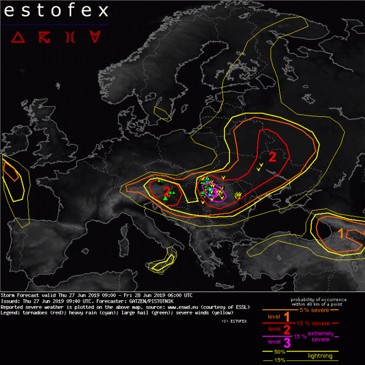
Storm Forecast
Valid: Thu 27 Jun 2019 09:00 to Fri 28 Jun 2019 06:00 UTC
Issued: Thu 27 Jun 2019 09:40
Forecaster: GATZEN/PISTOTNIKA level 3 is issued for E-most Hungary and W Romania mainly for large hail and severe convective wind gusts.
Level 1 and 2 areas are issued for parts of Belarus, SW-most Russia, the Ukraine, Moldova, Romania, Slovakia, Hungary, Serbia, Bosnia-Herzegovina, Croatia, Slovenia and Austria mainly for large hail and to a lesser degree severe convective wind gusts and excessive convective precipitation.
A level 1 is issued for the Celtic Sea south of Ireland mainly for large hail.
A level 1 is issued for NE Turkey, Georgia and the Russian Caucasus region mainly for large hail and to a lesser degree for severe convective wind gusts.
A level 1 is issued for the E Black Sea mainly for non-supercellular tornadoes (waterspouts).
SYNOPSIS
A high across northern Africa extends over France and ridges into the British Isles. At its western flank, a highly amplified trough is situated west of Europe. A plume of very warm, well-mixed air had spread into east Iberia, most of France, the Bay of Biscay, and southern British Isles. Another trough across Scandinavia amplifies over eastern Europe, associated with intense cold air advection over large portions of Europe. A frontal boundary extends from northern France to southern Germany, Hungary, and across the Ukraine and east Belarus, where a surface low moves east. Rich low-level moisture along this frontal boundary overlaps with steep lapse rates especially from France to Romania, where high CAPE develops. Finally, a weak trough is situated from Turkey to the south Mediterranean.
Kaart alle level 3 forecasts van Estofex
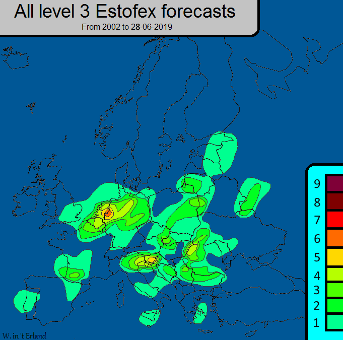
Ik heb een overzicht gemaakt van alle level 3 forecasts. De uitkomst vond ik vrij verrassend, Oost-Nederland heeft van Estofex de meeste level 3 forecasts gekregen, gevolgd door Slovenië en Noordwest-Roemenië. (Natuurlijk staat een level 3 forecast niet gelijk aan de hoeveelheid extreem weer.)
Een mogelijke verklaring voor de hoge hoeveelheid is de samenstelling het publiek en het team achter de forecasts. Ik denk dat Estofex toch beter bekend is in onze regio en dat ons gebied daarom ook wat meer aandacht krijgt door het team. Daarnaast is deze regio ook dichtbevolkt en daardoor lopen er misschien meer mensen risico bij noodweer.
3 juli 2019
Storm Forecast
Valid: Sat 06 Jul 2019 06:00 to Sun 07 Jul 2019 06:00 UTC
Issued: Fri 05 Jul 2019 23:27
Forecaster: PISTOTNIK
A level 3 is issued for NE Italy and S Austria mainly for large hail and to a lesser degree for severe convective wind gusts. In addition, tornadoes are possible in NE Italy.
A level 1 and level 2 are issued for a belt from central France to W Hungary and Slovenia mainly for large hail, severe convective wind gusts and excessive convective precipitation.
Level 1 areas are issued for S France and E Spain for large hail and severe convective wind gusts.
A level 1 is issued from the E Ukraine into W Russia mainly for excessive convective precipitation and to a lesser degree for large hail and severe convective wind gusts.
SYNOPSIS
Low 500 hPa geopotential stretches from Iceland to Scandinavia and NW Russia. An unseasonably strong mid-level jet is present at its southern flank. It gradually connects with a second jet streak over SW Europe ahead of a cut-off low west of Portugal, resulting in a broad zone of enhanced zonal flow across central Europe.
The associated frontal zone near the surface stretches from France to the Ukraine and remains stationary. Hot air is present to its south.
DISCUSSION
... France and greater Alpine region ...
An elevated mixed layer (EML), originally created over NW Africa and the Spanish plateau, is picked up by the increasing westerly flow and advected over the Alpine region, where it is reinforced by strong daytime heating. Low-level moisture has recovered well under the capping inversion on Friday. Since the upstream regions over France and Spain where largely devoid of convective overturning, the robust CAPE predictions that are offered by the forecast models for the warm side of the frontal zone on Saturday appear realistic or even too conservative. Expected CAPE magnitudes by Saturday afternoon are 500-1500 J/kg over central France, Switzerland and S Germany, 1000-2000 J/kg over S France and 2000-3000 J/kg over N Italy, but peak values along convergence zones may still be 1000 J/kg higher. The highly unstable airmass is overspread by steadily increasing vertical wind shear, often reaching or even exceeding 20 m/s across the 0-6 km layer in the afternoon and evening. This impressive CAPE-and-shear overlap sets the stage for the first day of a severe weather outbreak of possibly extraordinary dimensions.
The day may start with elevated and initially weak convection across central France near the forward rim of the EML. It is not ruled out that this convection will already start to root down until noon and bring first severe storms that move from E France into SW Germany and Switzerland. Otherwise, convective initiation becomes increasingly likely over orographic features from early afternoon onward. Model agreement about its timing and placement is limited, but subtle warm air advection, numerous crossing vorticity maxima and persistent upvalley and upslope circulations offer plentiful sources of lift across all scales, and the question is not IF, but rather WHEN convection will form. Towards evening, secondary initiation at outflow boundaries and other convergence zones becomes increasingly likely as well.
Storms will quickly organize into strong multicells, supercells and bowing lines or grow upscale into large clusters. Large hail and severe wind gusts are likely and scattered extreme events are foreseen across the entire level 2 area. Supercells with extremely large hail are more likely over the Alpine forelands, where enough low-level moisture is maintained beneath the capping inversion to allow fat CAPE profiles. in contrast, possible swaths of widespread severe to extreme wind gusts can explixitly include the Alpine terrain as well - deeper mixing and higher cloud bases can compensate a somewhat weaker storm organization, and the expected storm motion from west to east appears favorable for their gust fronts to burst out into major west-east running valleys.
The risk of extreme developments culminates on the southern side of the Alps in the late afternoon and evening. From 14 UTC onwards, storms from the southern Alps will likely start to descend into the Klagenfurt Basin (S Austria) and the plains of Friuli and Veneto (NE Italy), where they encounter the highest CAPE and the best wind profiles on the moist side of a dryline. Fine-meshed models agree on several right-moving supercells which can bring large to giant hail, downbursts and very heavy rain. In addition, a remarkable tornado risk unfolds in the NE Italian plains, where sea breezes enhance low-level shear and may boost 2m dewpoints to 24 or 25C by sunset. A few tornadoes are possible and even a strong tornado is not ruled out in case the track of a supercell can connect with an outflow boundary, the sea breeze front or another convergence zone.
Uncertainties of this forecast grow towards the east (E Austria, Slovenia, N Croatia, Hungary), where the CAPE buildup needs some hours more, the capping is stronger and synoptic lift arrives later. A few "cap breakers" over orographic features can organize well and turn severe, but could fall victim to the cap again soon after they detach from the mountains. There is some consensus that a large storm cluster will cross Austria and Slovenia overnight with an ongoing risk of severe wind gusts, excessive rain and localized large hail before it gradually decays over Hungary and Croatia. Tail-end storms to the south may still turn supercellular and propagate towards the unconsumed air further south, hence N Italy could repeatedly be affected by corridors of all kinds of severe to extreme weather throughout the night.
7 juli 2019
Storm Forecast
Valid: Sun 07 Jul 2019 06:00 to Mon 08 Jul 2019 06:00 UTC
Issued: Sat 06 Jul 2019 21:33
Forecaster: PUCIK
A level 3 was issued across NE Italy, Slovenia, N Croatia and N Bosnia mainly for damaging wind gusts, large to very large hail and excessive rainfall.
A level 2 was issued across N Italy, N Adriatic, N Bosnia, N Serbia into extreme W Romania mainly for large to very large hail and damaging wind gusts.
A level 2 was issued across E Slovakia into SW Ukraine and extreme NW Romania mainly for large to very large hail, severe wind gusts and excessive rainfall.
A level 1 was issued across Massif Central, N Alpine forelands mainly for large hail, excessive rainfall and severe wind gusts.
A level 1 was issued across Romania, Ukraine and Belarus mainly for severe wind gusts and large hail.
A level 1 was issued across E Spain mainly for severe wind gusts and large hail.
A level 1 was issued for the Caucasus region mainly for excessive rainfall and severe wind gusts.
SYNOPSIS
In a broad belt of strong zonal flow at mid to upper troposphere, several short-waves troughs are forecast to track from the Northern Sea through N Poland towards the Baltics and Russia. At the same time, closer to the surface, a low pressure system will move from the Baltic Sea towards Russia. Associated cold front, which will be located over N France, S Germany, Czech Republic and SE Poland on Sunday 06 UTC, will move towards the Alpine range and cross Austria, Hungary, much of Romania and Ukraine by the next morning. As strong mid-tropospheric flow will overlap moist boundary layer ahead of the front, large area over Europe, in a belt from E France towards Belarus, may experience at least isolated severe convective storms.
DISCUSSION
... N Italy towards W Romania ...
A severe weather outbreak is forecast over the area given overlap of 15 - 25 m/s of DLS with 1000 to 3000 J/kg of MLCAPE, yielding high probabilities of severe weather in any convective storm that forms. Scattered to widespread coverage of storms is forecast from NE Italy to Romania with cold front serving as a lift factor of virtually uncapped airmass. Coverage of storms becomes more questionable over NW Italy, given the fact that cold front does not reach this area and initiation will likely depend on the local topography.
Abundant convective activity may already be ongoing over the Alpine range and over N Italy / Slovenia on Sunday morning. Given the environment, this activity may already be severe and may impact the consequent development over the northern part of the area. As day progresses, further rounds of severe convective storms are forecast. It is likely that isolated supercells will form on the Alpine and N Appenines foothills in the early afternoon to evening hours and progress SE-wards, merging into one or more convective systems. High res NWP currently suggests that one such system may cross from NE Italy towards the Adriatics and another one from Slovenia towards Croatia, N Bosnia and Serbia. Towards the late evening and night hours, storms are forecast to reach and/or initiate over Romania.
Large to very large hail will accompany supercells, while well organised systems, including bow-echoes, may produce multiple swaths of damaging wind gusts. Tornado threat will be low initially given weak low level shear, but may increase towards the evening with strengthening wind field around the Adriatic Sea. Level 3 is introduced for the region where widespread storm activity is simulated in high CAPE and strong shear parameter space.
10 juli 2019
Storm Forecast
Valid: Wed 10 Jul 2019 09:00 to Thu 11 Jul 2019 06:00 UTC
Issued: Wed 10 Jul 2019 08:59
Forecaster: PUCIK
A level 3 was issued across Puglia, Italy, mainly for very large hail, damaging wind gusts, tornadoes and excessive rainfall.
A level 2 was issued across Central - South Italy, Albania, Montenegro, North Macedonia, Northern Greece mainly for large to very large hail, damaging wind gusts, tornadoes and excessive rainfall.
A level 1 surrounds Lvl 2 for areas with lower probablities of severe weather.
SYNOPSIS
Satellite imagery reveals a short-wave trough crossing Corsica and Sardegna at the moment, accompanied by isolated thunderstorm activity over these islands. The short-wave is forecast to rapidly translate E-wards, across Italy towards the S Balkans and NW Turkey. As the short-wave crosses the region with very moist airmass and the cold front sweeps across the Adriatic and Balkans towards the Ionian and the Aegean Sea, widespread thunderstorm activity is forecast from Central Italy to N Greece.
Scattered thunderstorms are also forecast over parts of Ukraine, Belarus and Russia, underneath an extensive cyclonic vortex, in the environment of marginal CAPE and weak vertical wind shear.
DISCUSSION
... Central Italy to N Greece ...
Ahead of the rapidly moving short-wave, mid-tropospheric wind field is forecast to strengthen considerably. Forecast hodographs reveal unseasonably strong bulk vertical wind shear, with 0-6 km values reaching 25 - 35 m/s and 0-3 km values 20 - 30 m/s. While hodographs will stay rather straight, enhanced SRH values are forecast particularly over the coastlines of Puglia with 0-3 km SRH reaching up to 400 m2/s2. Combined with 1000 to 2500 J/kg of MLCAPE in very moist airmass, any developing storm may either become a long-lived intense supercell or a bow-echo, capable of extremely severe weather. Convective mode, isolated cells or a large system, will likely impact the dominant type of severe weather.
As of 9 UTC, a long-lived, right-moving cell is moving along the western Adriatic Sea coastline and several elevated cells are ongoing across S Italy and parts of Balkans. Towards the early afternoon, convective coverage is forecast to rapidly increase over Italy and subsequently also over Balkans, in conjunction with the passage of the short-wave and the front. Storms will spread S and SE during the forecast period and are forecast to reach NW Turkey by Thursday morning.
Storms will be capable of all kinds of severe weather, including tornadoes and excessive precipitation, but the primary threats will be very large hail and damaging wind gusts. A level 3 is introduced for the area where NWP simulates widespread storms in high CAPE, strong shear and high SRH environment as the low level wind field backs to E-ly direction. However, it is possible that the cores of some of the storms will remain over the sea and in such case, severe weather would impact only the offshore areas. | Gewijzigd: 10 juli 2019, 12:28 uur, door Lako
2 augustus 2019 - Povlakte, Kroatië, Bosnië-Herzegovina
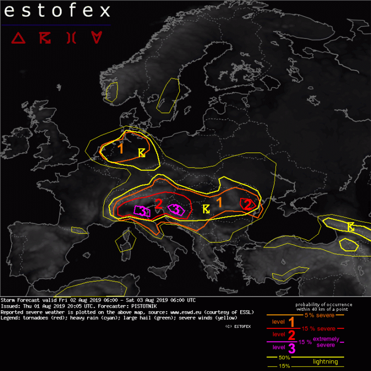
Level 3 areas are issued for small parts of NE Italy, Croatia and Bosnia-Herzegovina mainly for large hail, severe convective wind gusts and to a lesser extent for tornadoes.
SYNOPSIS
The main frontal zone runs on a quite southerly position between 45N and 50N from the Ukraine across the Alpine region to the Bay of Biscay. To its north, low-pressure systems are centered over NW Russia and over the N Atlantic west of Ireland. In-between, a formerly blocking Arctic high slips south towards the British Isles, but gradually flattens without interrupting the main frontal zone too much.
Steep lapse rates and rich low-level moisture overlap to the south of the frontal zone, in particular beneath an elevated mixed layer (EML) that is spreading from NW Africa to Italy and towards the Balkans. Cooler maritime air with adequate moisture but weaker lapse rates is present to its north. Finally, cold and dry air spreads into Scandinavia and NE Europe in the wake of the Russian cyclone.
8 juli 2020 - Rusland
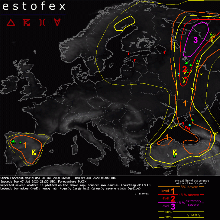
A level 3 was issued across northwestern Russia mainly for severe to extremely severe wind gusts, tornadoes, some possibly significant, and large to very large hail.
SYNOPSIS
Synoptic-scale situation will be dominated by a deep cyclonic vortex centered over the Baltic Sea. A short-wave trough will stretch from Belarus towards Ukraine at 06 UTC Wednesday and is forecast to move towards northeast during the day. Ahead of the vortex, strong low to mid-tropospheric flow is forecast along and ahead of the wavy frontal boundary. In the warm sector, an elevated mixed layer will have advected from Turkey and Caucasus towards northern Russia, overlapping with abundant lower tropospheric moisture with mixing ratios around 12 g/kg. Scattered to Widespread storms are forecast in a belt from Caucasus through southeastern Ukraine into western and northwestern Russia. Further storms are expected underneath the cyclonic vortex with modest lower tropospheric moisture and lapse rates exceeding 6.5 K/km. Isolated to scattered storms are also forecast over northern half of Iberia, underneath a cut-off low.
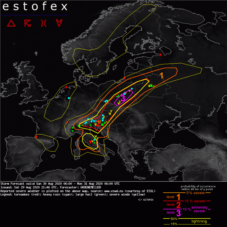
29 augustus 2020 - Povlakte, Italiaanse Alpen

A level 3 was issued for the southern Alpine flanks and the northern Po Valley, roughly from Milano to Pordenone (Friuli) for potentially strong tornadoes, large hail, extreme rainfall, and damaging winds.
SYNOPSIS
Between an elongated trough stretching from the North Sea to the Iberian Peninsula and a ridge along an axis from central Finland to Turkey, mid-tropospheric flow is from the southwest. As a shortwave trough rounds the base of the larger trough across Iberia a strong 30-40 m/s mid-level jet develops across the Western Mediterranean. At lower levels, a frontal zone roughly stretches from Southeast Spain via NW Italy to Northeast Poland. The air-mass on the warm side of the front is characterized by fairly steep mid-level lapse rates and high low-level humidity that in combination yield ample surface-based CAPE. As a result of this instability and the strong wind shear provided by the mid-level jet, severe convective storms are expected to develop near and on the warm side of the frontal zone.
30 augustus 2020 - Polen
A level 3 was issued across Poland across an area centered along a line from near Ostrava (Czechia) to near Warsaw.
SYNOPSIS
Between a longwave trough with an axis from from Denmark to Iberia and a broad ridge over eastern Europe, a strong south-westerly mid-level is present. Ample low-level humidity and adequate mid-level lapse rates render the troposphere potentially unstable across the central Mediterranean region and gradually across an increasing part of central Europe north and east of the Alps as well. Within this air-mass that is strongly sheared courtesy of the mid-level jet, severe storms are expected to persist and redevelop south of the Alps and to develop anew across the areas north and northeast of the Alps.
18 september 2020 - Medicane Griekenland
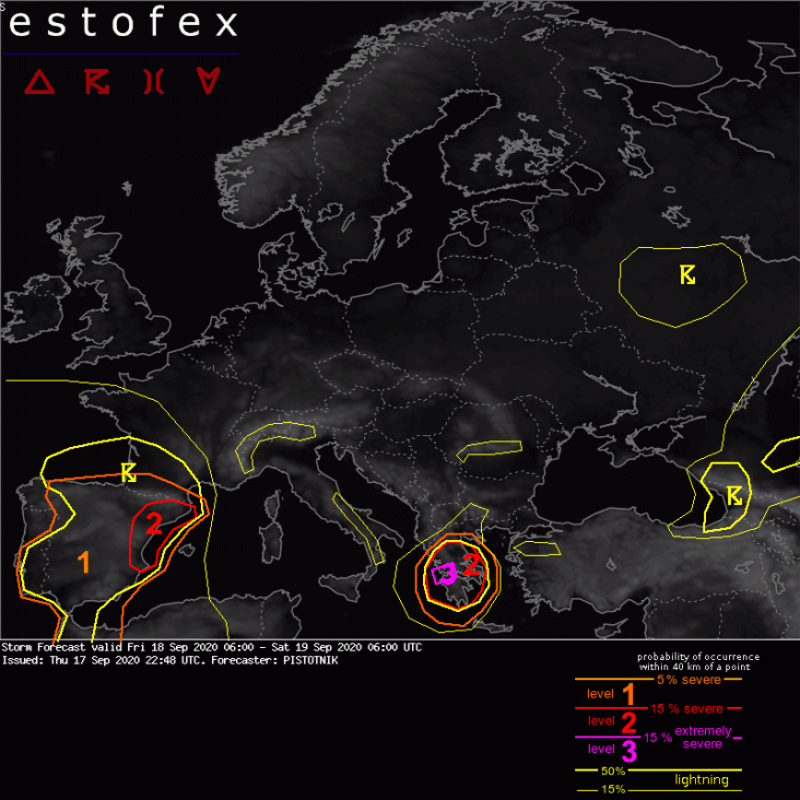
A level 3 is issued for a confined area in W Greece for severe convective wind gusts.
SYNOPSIS
A blocking anticyclone stretches from the North Atlantic Ocean to Romania. It is flanked to the SW by a cut-off low near Portugal, to the N by a strong zonal flow over Scandinavia, to the NE by another cut-off low in W Russia and to the SE by a suptropical cyclone over the Ionian Sea. Overall, the configuration somewhat resembles an "omega" pattern.
While a surge of polar air advances to the Black Sea in the wake of the eastern cut-off low, very warm air creates still summer-like conditions to the southwest of the axis of highest pressure / geopotential.
Storm Forecast
Valid: Sun 20 Jun 2021 06:00 to Mon 21 Jun 2021 06:00 UTC
Issued: Sun 20 Jun 2021 00:54
Forecaster: PISTOTNIK
A level 3 is issued for parts of Switzerland and Germany for severe convective wind gusts and large hail.
A level 1 and level 2 are issued for NE Spain, France and Belgium for severe convective wind gusts, large hail, excessive convective precipitation and to a lesser extent for tornadoes.
A level 1 and level 2 are issued for N Italy, Slovenia, Austria, Switzerland, Germany, Denmark and parts of Sweden for large hail, excessive convective precipitation and severe convective wind gusts.
A level 1 is issued from E Finland into NW Russia for severe convective wind gusts, large hail and tornadoes.
A level 1 issued for Bulgaria, W and central Turkey mainly for large hail and to a lesser degree for excessive convective precipitation and severe convective wind gusts.
A level 1 is issued for Romania for excessive convective precipitation and to a lesser extent for large hail.
A level 1 is issued for the W Ukraine, W Belarus and Lithuania for large hail, severe convective wind gusts and to a lesser extent for excessive convective precipitation.
SYNOPSIS
A long-wave trough stretches from the Norwegian Sea to the British Isles and Spain. Between this trough and a ridge across central Europe, a deep and strong S- to SW-erly flow (20-30 m/s at 500 hPa) advects very warm to hot air as far northward as Sweden and Finland. Two embedded short-wave troughs translate from central Germany (Sun 06 UTC) to central Sweden (Mon 00 UTC) and from Catalonia (Sun 06 UTC) to central Germany (Mon 00 UTC), respectively, and modulate the position of a diffuse, wavy but otherwise stationary frontal boundary. Especially the second short-wave trough will be the main focus for severe thunderstorm activity.
Further downstream, an old cut-off low over Romania, Bulgaria and W Turkey slowly fills and creates unsettled, moderately warm weather in these regions. At its forward flank, another stream of hot air from the Russian plains is directed NW-ward to Belarus and the Baltic States. The Mediterranean region and European Russia are under anticyclonic influence with calm and anomalously warm weather.
DISCUSSION
... NE Spain, France, Switzerland, most of Germany (SW of the Elbe river), BeNeLux ...
The weather pattern brings together the ingredients for organized, long-lived and severe thunderstorms over an exceptionally large area. Steep lapse rates from NW Africa and Spain are advected on top of decent, though somewhat variable, low-level moisture in west-central Europe with 2m dewpoints mostly in the mid- to upper tens. After some hours of daytime heating and supported by a return of strong warm air advection, CAPE on the order of 500-2000 J/kg builds by afternoon and is collocated with 0-6 km shear between 15 and 25 m/s. In general, CAPE is higher towards the SE and shear stronger towards the NW, but the overlap is robust.
At the time of writing (Sat 22 UTC), intense and organized storm activity in the range of the diffuse frontal boundary has spread from France into Belgium, Luxemburg and W Germany. It is expected to overspread most of the W half of Germany in the course of the night while it slowly weakens. Westerly outflow winds will probably push as far eastward as the Czech and Austrian border and align with the north Alpine rim in Switzerland by Sunday morning. With the onset of daytime heating and increasing warm air advection aloft, suppressed vertical mixing in this slightly cooler but moist air can create a "loaded gun" situation with CAPE approaching or even exceeding 2000 J/kg (a similar CAPE amount was already sampled by the Saturday 12 UTC soundings from Payerne and Munich). In addition, surface winds gradually veer from westerly to northerly to easterly directions under the influence of an Alpine heat low. Depending on the balance between this Alpine pumping and a possible downward propagation of hot and dry Foehn winds in the central Alps, the convergence zone may further sharpen and attain the characteristics of a dryline in the course of the day while it is predicted to remain stationary along the north Alpine rim.
Thunderstorm activity on Sunday morning will initially be widely scattered, mostly elevated and poses a limited severe weather risk. It might even completely decay for a couple of hours. As daytime heating proceeds and the lift area of the short-wave trough advances NE-ward, scattered surface-based initiation becomes more and more likely from late morning onwards in NE Spain and S France, from early afternoon onwards in E France and Switzerland, and in the latter half of the afternoon in Germany.
Most forecast models simulate a more or less quick upscale growth into one or two large bowing lines, which can produce widespread severe and even scattered extreme (> 32 m/s) wind gusts, owing both to the strenghtening mid-level wind field and plentiful subcloud evaporation due to the rather high cloud bases. However, the scatter of simulated storm tracks is also extremely large, spanning a more than 500 km wide corridor from Luxemburg in the NW to the German/Austrian border in the SE. These uncertainties can be tracked back on the one hand to inherent difficulties of forecast models to represent an as dynamic and fast-moving feature as this short-wave trough, on the other to the disjunction of lift mechanisms: While the dominant source of lift at low levels is the above-mentioned outflow boundary / dryline near the north Alpine rim, the bulk of the mid-level forcing connected to the short-wave trough will race quickly northeastward across France and Germany. The possible storm tracks are therefore connected to the relative importance of these two lift mechanisms in the "forecast model world".
The mean track of a long-lived bow echo - shall it develop - runs roughly from Bern (Switzerland) towards Leipzig (Germany). While the forecast model pool exhibits a slight overhang towards the northwestern solutions (i.e., driven more strongly by the synoptic lift of the trough), the sheer abundance of CAPE in the loaded gun environment in the Alpine forelands and the more dependable lift along the outflow boundary would be weighty arguments for a more southeasterly track. Taking further into account the higher conditional wind risk in the drier environmental air further SE and the backstop of a possible, more discrete, supercellular storm mode with an additional risk of large to very large hail, the risk level areas are slightly adjusted towards the southeast. Despite these large uncertainties, a level 3 corridor seems to be warranted where both a bowing line with severe to extreme wind gusts or supercells with large to very large hail may occur.
In the course of the evening and night, storms will cross large parts of Germany. They will gradually weaken and become elevated when they outrun the zone of robust CAPE. The hail hazard decreases first, whereas the risk of severe wind gusts and heavy to excessive rain still remains slightly enhanced until Monday morning.
As the short-wave trough and its dominant wave of storms depart, moderate CAPE and moderate to strong vertical wind shear still remain in place across much of France. In the absence of synoptic lift, mesoscale lift mechanisms like thermally or dynamically driven flow convergence over mountains, cross circulations in the range of the diffuse frontal zone, or outflow boundaries take over as possible initiation mechanisms. Scattered storms in form of multicells, supercells or a few large clusters are possible all evening and night long, only slowly tapering off. While storm coverage will likely not be too high, all kinds of severe weather may occur. Next to large hail, severe downbursts and excessive rain, also one or two tornadoes are not ruled out, owing to lower cloud bases and increasing vertical wind shear also across lower levels.
... N Italy, Austria, Slovenia ...
Robust CAPE (500-1500 J/kg over the Alps, around or above 2000 J/kg over the forelands) has built after several days of net synoptic subsidence and strong capping (resulting from a combination of warm air advection and negative vorticity advection ahead of the ridge axis). It is collocated with 10-15 m/s deep-layer shear, as slightly enhanced W- to NW-erly mid-level winds round the ridge axis. Vertical wind shear across lower layers is weak.
Isolated to scattered afternoon storms are expected to overcome the synoptic subsidence and entrainment of dry environmental air. They can organize into strong multicells or transient supercells with a main risk of large to very large hail and secondary risks of localized downbursts and flash floods. Storms will be strictly tied to the mountains and decay as soon as they propagate into the strongly capped forelands, and activity should also quickly die off in the evening.
The only exception is NW Italy, where a larger and more persistent storm cluster may evolve in the evening, in case the fringes of the trough's synoptic lift spread far enough eastward. This scenario would further enhance the severe weather risk and shift it somewhat more to severe winds. It is not ruled out, albeit unlikely, that such an MCS may propagate a little distance into the western Po Valley in the evening and first half of the night.
... NE Germany, NW Poland, Denmark, S and central Sweden ...
Some CAPE is also present ahead of the first (northern) short-wave trough, ranging from a few hundred J/Kg in Denmark and Sweden to locally up to 1500 J/kg in a narrow zone ahead of the trough axis in NE Germany. Scattered thunderstorms may be active as a leftover from the previous night or form anew in the course of the late morning and afternoon. Fairly strong deep-layer shear around 20 m/s and veering wind profiles allow well-organized multicells and perhaps supercells with a risk of large hail, severe wind gusts and localized heavy rain. The severe weather risk is highest in NE Germany, which falls just short of a small level 2 (due to the fragile-looking CAPE tongue).
As storms move northward into Sweden, they gradually run out of CAPE and can merely hang on the trough's strong lift for some more hours. While the wind field remains strong, the increasingly embedded (and possibly elevated) nature of this convection decreases the severe weather risk.
... Level 1 belt in the bordering area of Finland and Russia ...
A narrow belt of some hundred J/kg CAPE is also present at the northern rim of the warm airmass and overlaps with enhanced vertical wind shear across all layers, including 10-15 m/s low-level shear. As the frontal boundary turns cold-active in the course in the afternoon and evening, scattered multi- or supercellular storms are possible. Isolated severe wind gusts, marginally large hail and tornadoes may occur. A limiting factor is the rather weak lapse rates, and the therefore limited CAPE magnitude.
.. Romania, Bulgaria, NE Greece, W Turkey ...
Moist, moderately warm air in the range of the cut-off low allows up to 1000 J/kg CAPE. Scattered afternoon storms are expected, especially (though not exclusively) over mountains. The main risks are excessive convective precipitation next to marginally large hail or copious amounts of small hail.
In the periphery of the cut-off low from Bulgaria to Turkey, moderately enhanced deep-layer shear (10-15 m/s) and slightly steeper lapse rates shift the main risk more towards hail, while localized excessive rain and severe wind gusts are not ruled out, either.
... W Ukraine, W Belarus, Lithuania, Latvia, Estonia ...
In the warm air advection regime ahead of the Balkans cut-off low, steep lapse rates move on top of decent low-level moisture, resulting in CAPE on the order of 500-1500 J/kg. Despite some synoptic lift, breaking the capping inversion may be a difficult venture. ECMWF and ICON-EU show no signals for convective precipitation at all, whereas GFS offers scattered afternoon and evening storms. Despite weak vertical wind shear, strong pulse storms could produce isolated large hail, downbursts or heavy rain, in case the cap breaks as suggested by GFS. A combination of a (low-end) level 1 and a low-probability lightning area covers this scenario. | Gewijzigd: 24 juni 2021, 12:03 uur, door Lako
Storm Forecast
Valid: Thu 24 Jun 2021 06:00 to Fri 25 Jun 2021 06:00 UTC
Issued: Thu 24 Jun 2021 00:21
Forecaster: GATZEN
A level 3 was issued across northern Austria into southern Czech Republic for large hail and severe wind gusts.
A level 2 was issued across the western and northern Alpine region, SE Germany, Czechia, Slovakia, and southern Poland for large hail, severe wind gusts, heavy rainfall, and tornadoes.
A level 2 was issued for eastern Romania and Bulgaria mainly for large hail.
A level 2 was issued for the Caucasus region mainly for large hail and severe wind gusts.
A level 2 was issued for northern Russia mainly for severe wind gusts and tornadoes and to a lesser extend large hail.
A level 1 was issued across eastern Poland, SE Baltic States, W Belarus, W Russia, SW Ukraine for large hail, severe wind gusts and heavy rainfall.
A level 1 was issued for northern Algeria and Tunisia for severe wind gusts.
SYNOPSIS
A mid-level jet extends from the west Mediterranean towards Poland and farther into east Scandinavia ahead of a slowly lifting west-European trough, with several vorticity maxima that travel north-east. Downstream ridging remains from the central Mediterranean to western Russia upstream of a quasi-stationary cut-off trough centred across the Black Sea and Turkey.
A frontal boundary from northern Iberia and the west Mediterranean to the central Alps, Baltic States and northern Russia separates Atlantic air masses from steep lapse rates across most of southern and eastern Europe. Rich low-level moisture is present along this frontal boundary and overlaps with steep lapse rates. Additionally, ample moisture affects the Black Sea region, and robust MLCAPE is expected over eastern Europe. To the west, less CAPE but strong vertical wind shear create an environment favorable for organized convection.
DISCUSSION
Western and northern Alpine region into SE Germany, Czechia, Slovakia and S Poland
A strong south-westerly mid-level jet slowly progresses eastward on Thursday. An embedded short-wave trough spreads north-east and associated differential vorticity advection increases during the day. At lower levels, a frontal boundary extends from the western Alps towards SE Germany and into Czechia. Moist and unstable air are present to the south-east of this boundary. In response to pressure falls north of the Alps, moisture will return westward during the day and warm air advection sets in.
Convection initiation will become more likely during the day, with a peak of convective activity in the evening. Main focus will be storms forming along a cold front that progresses over southern Germany in the afternoon, but more isolated storms are also possible in the warm air advection regime farther east. Strong deep layer shear of 20 to 30 m/s will support supercells capable of giant hail and severe wind gusts. A level 3 was issued for the area with highest expected storm coverage.
Due to the high coverage of storms and strong 0-3 km wind shear, formation of foreward propagating MCSs and bow echoes is expected, with severe winds becoming the main threat. A tornado is not ruled out, with increasing potential across Slovakia due to strong low-level vertical wind shear that develops in the evening.
Clusters elevated storms are expected to persist for most of the night while progressing across Poland, with slowly decreasing risk of severe wind gusts and large hail. | Gewijzigd: 31 juli 2021, 12:50 uur, door Lako
Storm Forecast
Valid: Sun 25 Jul 2021 06:00 to Mon 26 Jul 2021 06:00 UTC
Issued: Sat 24 Jul 2021 16:56
Forecaster: PISTOTNIK
A level 3 is issued for far-south Germany into N Austria for large hail and severe convective wind gusts.
A level 1 and level 2 are issued for Switzerland, SE Germany, the Czech Republic, Austria and N Italy for large hail, severe convective wind gusts and excessive convective precipitation.
A level 1 is issued for the rest of Germany mainly for excessive convective precipitation and to a lesser extent for large hail.
A level 1 is issued for SE England, N France, BeNeLux and Denmark mainly for excessive convective precipitation.
A level 1 is issued for E Spain mainly for large hail.
A level 1 is issued for SW Turkey mainly for large hail.
SYNOPSIS
The dominant feature on the weather maps is a cut-off low centered over the Channel, whose periphery spreads ober Iberia, France, Germany, Denmark and the British Isles. It is filled with moist and temperate maritime air. A compact surface low emerges from Saturday's thunderstorm activity at its forward flank over W Germany and BeNeLux and drifts offshore onto the North Sea.
Further east, pressure and temperature gradients are weak. A warm, blocking anticyclone stretches from Scandinavia to the Ukraine and SW Russia. It is flanked by a shallow cut-off low over Turkey and strong zonal flow in the far NE of our forecast domain.
The subtropic branch of the jet stream stretches from Iberia to the Alpine region before it curves towards Greece and the E Mediterranean Sea. It partly overlaps with hot, moderately to highly unstable air and sets the stage for an expected outbreak of organized, severe thunderstorms in particular in the Alpine region.
DISCUSSION
Switzerland, SE Germany, N Austria, Czech Republic
The most dangerous setup develops on the northern side of the Alps. The SW-erly mid-level flow supplies persistent warm air advection. Though the initially steepest lapse rates, associated with an elevated mixed layer (EML) from NW Africa and Spain, rather graze the area to the south, the fetch of the airflow over the Alpine range is also long enough to create a secondary maximum of steep lapse rates in response to daytime heating and advect it onto rich low-level moisture in the northern forelands. Global models suggest that 500-2000 J/kg CAPE will develop over the entire area and overlap with moderate deep-layer shear (10-15 m/s) and veering wind profiles. However, as usual in this pattern, both CAPE and vertical wind shear will likely be boosted to much higher values in a 50-100 km wide belt where moist NE-erly upvalley circulations undercut the "Alpine plume" of steepened lapse rates. Consequently, high-resolution models like COSMO-D2, WRF and AROME, which can best simulate this delicate interplay, agree on an elongated corridor along the North Alpine rim where 2000-4000 J/kg CAPE are collocated with 20 m/s deep-layer shear.
A few mostly weak and elevated storms may be left over from the previous night or already form in the morning, mostly in the Czech Republic where the nose of the warm air advection regime creates synoptic lift. As daytime heating proceeds and several mid-level vorticity maxima cross the Alps, the chances for surface-based convective initiation over orographic features, along insolation gradients and various convergence zones rapidly increase around 12 UTC and afterwards.
Storms forming along the North Alpine rim are expected to quickly organize into supercells, whose right-moving tracks should allow them to perfectly follow the CAPE and shear maximum. Large to very large hail is likely with any storm that forms in this corridor, accompanied by severe downbursts and heavy rain. If one dominant supercell manages to emerge, even giant hail (8+ cm) is possible.
There are some signals that the primary storm mode could change from discrete, supercellular storms to a bowing line in the latter half of the afternoon, while the bulk of the activity advances from SE Bavaria into Upper Austria and Bohemia. In that case, the main risk would shift to scattered or widespread severe wind gusts, perhaps also including a few extreme events.
The further trajectory towards the E or NE leads the storms into still plentiful CAPE but relaxing vertical wind shear in NE Austria and Moravia. This would be a prime environment for the healthy and widespread convective activity to grow upscale into a mesoscale convective vortex that enters the Czech Republic in the evening and the first half of the night, and in fact quite a number of model forecasts shows such a scenario. While the hail and wind risks decrease, excessive precipitation becomes the main issue and may continue until midnight, before the convection finally becomes elevated and weakens.
26 juli
Storm Forecast
Valid: Mon 26 Jul 2021 06:00 to Tue 27 Jul 2021 06:00 UTC
Issued: Mon 26 Jul 2021 02:26
Forecaster: BEYER
A level 3 was issued along the northern Alpine rim in Austria mainly for (very) large hail, (extreme) severe wind gusts, and excessive precipitation.
A level 3 was issued for parts of Northern Italy mainly for (very) large hail, (extreme) severe wind gusts, and excessive precipitation. A tornado is not excluded.
A level 2 was issued for the surrounding Greater Alpine region mainly due to the same threats but with less likelihood for extreme events.
A level 2 was issued for Northeastern Germany into Denmark mainly due to excessive precipitation.
A level 1 was issued for parts of Central Europa for locally excessive precipitation.
A level 1 was issued for Eastern Poland mainly for excessive precipitation
A level 1 was issued for Eastern Spain mainly for excessive precipitation and severe wind gusts.
A level 1 was issued for Northern Turkey and Caucasus mainly for excessive precipitation and large hail and to a lesser extent for severe wind gusts.
A level 1 was issued for parts of Northwestern Russia mainly for severe wind gusts.
SYNOPSIS
A long-wave trough is persistently situated over Western Europa that has an independent center over NW France and the North Sea. Central and Eastern Europe are lying on the forward flank of this through in a diffluent upper-level flow. Warm and humid airmasses are present in all of this area.
Several short wave features are traveling northeastward leading to maxima in the omega field, responsible for the different regions of interest.
The trough axis is situated over E Spain and travels slowly eastward throughout the forecast period. Another but weaker trough can be found over SE Europe. NE Turkey and the Caucasus region is situated on its forward flank.
NW Russia is influenced by the rear flank of another trough. A cold front is passing this area from north to south. Thereafter cool airmasses spread that region with a northwesterly flow.
DISCUSSION
Greater Alpine region
Ahead of the diffuse and almost stationary cold front, a plume of steep lapse rates (the remnants of an elevated mixed layer from the Sahara) are reinforced by diurnal heating over the Alps. As they overspread moist low-level air over the forelands with 2m dewpoints in the upper tens or locally lower twenties, about 500-1500 J/kg CAPE are created and overlap with moderate deep-layer shear (10-15 m/s) and veering wind profiles in the lowest layers. Even more CAPE and stronger shear are likely in N Italy, which is situated closest to the jet maximum, and more locally along the north Alpine rim in Austria, where moist NE-erly upvalley circulations undercut the SW-erly mid-level flow. In these two regions, an overlap of ~2000 J/kg CAPE and ~20 m/s deep-layer shear will likely be realized according to high-resolution forecast models.
With the help of various mid-level vorticity maxima and the rather strong SW flow storms will initiate on the leeward flank of the N Apennines and E Alps in the afternoon and evening hours. A high degree of storm organization into strong multicells and supercells is expected given the high shear values. High resolution models simulate several long-tracked supercells.
Later some of these storms may grow into a few MCSs. While at the beginning large hail and severe wind gusts are a main, clustering will enhance the possibility for excessive precipitation. Rather high mid-level shear (0-3km) also enhances the risk for bowing segments that then again pose a threat for severe wind gusts.
Isolated to scattered extreme events are foreseen, especially in the mentioned regions of best overlap of enhanced CAPE and vertical wind shear.
In the plains of N Italy, low cloud bases and locally enhanced 0-1 km shear also point to a possibility of one or two tornadoes.
Storm Forecast
Valid: Sat 31 Jul 2021 06:00 to Sun 01 Aug 2021 06:00 UTC
Issued: Fri 30 Jul 2021 14:13
Forecaster: TUSCHY
A level 3 was issued for N Italy into extreme S Austria mainly for very large to giant hail and severe to extreme wind gusts.
A level 2 surrounds the level 3 mainly for (very) large hail, severe wind gusts and heavy rain.
A level 2 was issued across far E Spain to the Balearic Islands mainly for (very) large hail, severe wind gusts and heavy rain.
A level 1 surrounds both level 2 areas with similar hazards but with less coverage. An isolated (nocturnal) tornado threat exists over NW and NE Italy into Slovenia/far NW Croatia. Also along the E-CNTRL coast of Spain and over SE Austria into extreme W Hungary.
A level 1 was issued for the SE Ukraine into SW Russia mainly for hail and excessive rain.
A level 1 was issued for parts of the Baltic States/Sea and SE Sweden mainly for severe wind gusts. An isolated tornado event is possible.
A level 1 was issued for N Algeria mainly for large hail and strong to severe downbursts.
A level 1 was issued for far N Germany mainly for a few severe wind gusts and an isolated tornado threat.
SYNOPSIS
One of the four dominant north hemispheric Rossby waves is forecast to cover most of Scandinavia down to the Iberian Peninsula. This wave has numerous smaller scale embedded vorticity maxima - one crossing Denmark E/NE with another one impacting most of Spain/SW France during this forecast.
The eastern fringe of this Rossby wave is framed by a wavy and gradually eastward shifting frontal boundary, which separates a warm/hot and humid airmass over S-Euope from a drier/more stable one to its north.
Downstream ridge covers most of CNTRL/E Mediterranean into E Europe with a broad/ill defined upper wave over the Near East.
Overall model performance is good, with models showing a nice consistency during the past few runs - valid for GFS/IFS and ICON. Some discrepancies regarding timing exist with the Spanish wave as ICON f.ex. speeds up in the past 2 runs. However it is still unclear if this trend persists. Overall this won't lower the expectations in a severe risk as general geometry of the hight field agrees well in NWP.
DISCUSSION (UPDATE)
A widespread outbreak of severe thunderstorms is forecast for parts of SW into S-CNTRL Europe. For a more detailed discussion please check yesterday's extended outlook which is attached. We will just update any changes for this SOWDY 1.
... E Spain to the Balearic Islands to N Italy into Hungary/Austria and Switzerland...
Still a complex forecast over E/NE Spain to the Balearic Islands with less aggressive NWP guidance compared to this pugnacious outlook. However there is not much in the way for developing organized convection over E/NE Spain which grows upscale while racing towards the Balearic Islands. Intense QG forcing for this time of year should overcome capping issues, although offshore moving convection might become more elevated betimes. Very large to giant hail with damaging wind gusts are possible in this level 2. An isolated tornado is possible along the coastal areas of E-Spain, where maturing supercells interact with the sea breeze. Locally excessive rain is an issue with merging and initiating cells along the orography.
The level 2 over N Sardegna/Corse was re-issued despite meager QPF signals in NWP guidance. I weightened the EPS output more as a few members seem to break the cap. Passing short-wave should add enough input for elevated convection with large hail and heavy rain the main risk. This part of the level 2 remains quite uncertain and is a nocturnal event.
Not much change to the level 2 over N Italy into parts of Austria/Hungary and Slovenia despite a broad upgrade to a level 3. Some LAMs keep convection attached to the Alps, but this seems unlikely. Apart from the mountains CI will be delayed until the afternoon. Thereafter, long-tracked severe supercells with very large/giant hail, damaging winds (locally in excess of 65kt) and heavy rain are forecast. The tornado risk ramps up in the eastern part of the level 3 with enhanced LL directional/speed shear and rather low LCLs - only the upscale growth into a severe bow echo may lower the general risk a bit (isolated discrete convection still possible next to the N-Adriatic Sea).
There is not much reasoning against this MCS to race trough E-Austria during the night, attached to the progressive short-wave. A general decrease in severe is forecast with weakening CAPE but still impressive shear.
The level 3 was expanded into SE Austria, where a cluster of supercells are forecast during the afternoon/evening (prior to the nocturnal MCS event). (Very) large hail/excessive rain and severe wind gusts occur next to an isolated tornado threat.
We expanded the level 2 more into W Hungary as maturing multicells/supercells from SE Austria grow upscale during the afternoon/evening hours. Large hail/severe wind gusts will be the main issue but an isolated tornado event is possible with deviating cell motion.
The level 3 was expanded into the Lombardy for numerous waves with (extremely) severe events - first supercells during the afternoon/evening and clustering convection during the night with a serious flash flood threat (some ID2 members approach 180 l/qm/6h during parts of the overnight hours).
Storm Forecast
Valid: Thu 05 Aug 2021 06:00 to Fri 06 Aug 2021 06:00 UTC
Issued: Wed 04 Aug 2021 22:41
Forecaster: GROENEMEIJER
A level 3 was issued across Ukraine for all hazards including strong tornadoes, severe wind gusts, large or very large hail, and very heavy rainfall.
A level 2 was issued across a large area including parts of Romania, Moldova, Ukraine, Slovakia, and Poland. Across Poland, Slovakia, NW Ukraine, and Romania, very heavy rainfall is an important hazard. Across all but southern Poland and Slovakia, large hail, severe winds, and tornadoes are important hazards.
A level 1 was issued for parts of the Ukraine and Russia mainly for isolated large hail and to a lesser extent for severe wind and heavy rainfall.
A level 1 was issued across the Central and Western Balkans and the Pannonian Plain, mainly for isolated large hail and locally very heavy rainfall.
A level 1 was issued across Northwest Poland, North Germany, and the Netherlands for local, heavy rainfall.
+ + + A tornado outbreak is forecast across Ukraine, Moldove and Northeast Romania + + +
SYNOPSIS
An intense shortwave trough initially over the Adriatic Sea tracks east-northeastward to reach Belarus Friday morning. Pressure falls ahead of it lead to a deepening surface cyclone that will move from Hungary to eastern Poland.
DISCUSSION
Ukraine, Moldova, Romania...
On the southeastern flank of the surface low, a southerly mid-level flow advects an elevated mixed layer from Greece northward across the central and Eastern Balkan Peninsula. At the same time, very humid low-level air is advected northwestward across eastern Romania, Moldova, and the western and central Ukraine.
Within this plume, high instability is predicted with more than 3500 J/kg of MLCAPE over Eastern Ukraine, between 2000 and 3000 over Moldova and Southwest Ukraine decreasing to near 500 J/kg toward the Ukraine/Poland and Ukraine/Slovakia border.
Across this same region, exceptionally strong low-level helicity will develop in the early evening, with 150-250 m2/s2 of 0-1 km storm-relative helicity generally in place across the level 3 area and into eastern Romania at 18 UTC per ECMWF.
NWP guidance suggests that capping will prevent convective initiation until the late afternoon when the quasi-geostrophic forcing for lift from the through will affect the region. Convective initiation will probably commence over the Southern Carpathians and closer to the low over the Western Carpathians and western Ukraine, before initiation will also occur over the Eastern Carpathians.
Given 20-25 m/s deep-layer shear, a number of supercells will likely rapidly evolve with a threat of very large hail (> 5 cm diameter) likely. Given the amount of deep-layer shear, the storms within and near the level 3 area will have a risk of producing a couple of strong (>=F2) or even intense tornadoes (>=F3) possible. Gradually, storms will likely cluster and may evolve into a few bowing segments with a damaging wind threat.
Valid: Wed 16 Feb 2022 07:00 to Thu 17 Feb 2022 06:00 UTC
Issued: Wed 16 Feb 2022 07:26
Forecaster: PUCIK / TUSCHY
A level 3 was issued for N Germany and W Poland mainly for extremely severe wind gusts and tornadoes.
A level 2 was issued in a belt from N Ireland through the central UK towards the Netherlands, N Germany, and Poland for widespread severe wind gusts and tornadoes.
A level 1 was issued for W Greece mainly for heavy rain and waterspout risk.
SYNOPSIS
NAO+ features a strong ridge building into SW Europe with anomalous low heights between S Greenland to Norway. A tightening thermal gradient in between evolves and causes a strong mid/upper jet configuration with speed anomalies in the Q90 range for the 79-00 CFSR climatology (200 hPa u wind). This jet crosses the UK and pushes into Central Europe during the night.
Left exit region of the seasonably strong jet-streak results in pressure falls over S Norway and a gradually consolidating surface low is forecast to exit Scotland, cross the North Sea and S Norway before entering the Baltic Sea during the end of the forecast. IFS-ENS MSLP forecasts cluster around 965 hPa with a few members down to 960 hPa (similar to GFS/GEFS). A cold front will cross the whole region in the evening to overnight hours.
A cut-off low slowly moves across the Ionian Sea towards the SE. A diffuse low-level vortex accompanies this event, which pushes an occluded front towards Greece.
DISCUSSION
... UK through BENELUX towards Poland ...
A long-lived convective windstorm is expected to cross the region between Wednesday evening and Thursday morning.
Ahead of the cold front, abundant low-level moisture with mixing ratios exceeding 7g/kg will be available. Combined with strong forcing and steepening mid-tropospheric lapse rates, marginal CAPE will develop along the cold front with MLCAPE values between 100 and 200 J/kg. Kinematics along this front will be impressive as the 1 km AGL flow reaches 35 - 40 m/s, yielding 0-1 km bulk shear values of 20 - 25 m/s. As low-level lapse rates steepen with mixing ahead of the front, effective downward transport of momentum is forecast. Numerous convection-allowing models simulate the development of one or more convective lines that will progress SE across the area. Widespread convectively enhanced severe to extremely severe gusts will occur along these lines. The threat will pick up in the 15 - 18 UTC timeframe over the UK, between 21 - 00 UTC over BENELUX and W Germany, and towards 06 UTC over central Poland.
Besides the wind threat, an isolated tornado risk will be present along the convective line, especially if line-echo wave pattern develops. ICON D2 simulates a number of enhanced vorticity tracks, suggestive of areas of rotation within the convective line. The tornado threat will be augmented by the presence of rather large SRH (> 300 m2/s2 in the 0-1 km layer) ahead of the cold front, low LCLs, and steep low-level lapse rates. A strong tornado can not be ruled out given large magnitudes of low-level shear.
Storm Forecast
Valid: Sun 20 Feb 2022 06:00 to Mon 21 Feb 2022 06:00 UTC
Issued: Sat 19 Feb 2022 22:07
Forecaster: GROENEMEIJER
A level 3 was issued across western and south-western Scotland, northeastern England, and northern parts of the island of Ireland mainly for severe wind gusts.
A level 2 was issued across large parts of England, Wales, the island of Ireland, the Benelux, and across far northern France and western parts of Germany for severe wind gusts and to a lesser extent for tornadoes.
British Isles, Benelux, France, Germany, and central Europe...
A strong WNW-ESE oriented jet streak with 150-200 kt wind speeds at 300 mb rapidly translates ESE-ward with its right exit quadrant about 600 km west of NW Ireland at 12 UTC, over the Irish Sea at 18 UTC, the southern North Sea at 00 UTC, and north-central France at 06 UTC. Strong quasi-geostrophic forcing for upward motion and resulting destabilization is expected to move in concert with it, which will force linear convection along and behind a cold front that will move southeastward from Western Scotland and Ireland southeastward across the British Isles and reach the Alps on Monday morning.
The front should become defined as a rainband as low-level convergence increases during the morning and the afternoon when it tracks southeastward across Wales and England. The strong background wind field of 30-35 m/s at 850 mb suggests that severe gusts should gradually become an increasing risk. Some very severe gusts of over 32 m/s may occur especially while crossing the North Sea and affecting the Benelux countries.
Convection allowing models suggest that some mesovortices may develop along the line in particular when it moves inland across the Benelux, northern France and western Germany where it encounters strongly helical low-level flow (>400 m2/s2 storm-relative helicity in the 0-1 km layer) This would suggest that an enhanced risk of very severe gusts > 32 to extend inland, as well as a risk of tornadoes.
Limiting factors to their development, however, are the moderate convergence and wind shift along the line, which in the ICON-D2 model yield, fortunately, values of vertical vorticity of about half to two-thirds of those that were predicted for the line that produced multiple tornadoes in Poland early on Friday. Some risk for tornadoes will nevertheless remain. The risk for severe weather overall is expected to slowly diminish as the forcing of the upper-level jet/vorticity maximum slowly weakens toward the morning.
Scotland, northern England and Wales, Ireland...
The upper-level vorticity maximum on the polar side of the leading part of the jet streak is followed by a second one, which can better be described as a low-to mid-level vorticity maximum with a deep, but slowly filling surface low. This system causes destabilization that will invigorate a second area of convection approaching Scotland and Ireland between 21 and 00 UTC. Because it is embedded in a particularly strong flow and linear organisation is likely as it moves southward after midnight UTC, a level 3 was issued for the area that will be affected. Very severe gusts exceeding 32 m/s will be fairly widespread with the convection, also across areas somewhat further inland. That being said, the convection is not the only culprit: especially the coastal regions of western Scotland and in the north of Ireland will also experience such severe gusts outside of convective storms as a result of the very tight pressure gradient. | Gewijzigd: 21 februari 2022, 14:31 uur, door Lako
Storm Forecast
Valid: Fri 20 May 2022 08:00 to Sat 21 May 2022 06:00 UTC
Issued: Fri 20 May 2022 07:49
Forecaster: PUCIK
A level 3 was issued in a belt of north - central Germany for severe to extremely severe wind gusts, large hail, tornadoes and excessive rainfall.
A level 2 was issued in a belt from northwestern France through Germany into Czechia and Poland mainly for severe to extremely severe wind gusts, large hail and tornadoes.
A level 1 was issued across northern Germany and northern Poland mainly for excessive rainfall and severe wind gusts.
A level 1 was issued across central France, southern Germany and northwestern Austria mainly for large hail and severe wind gusts.
A level 1 was issued across southern Russia mainly for severe wind gusts and to the lesser degree for tornadoes.
SYNOPSIS
At the mid to upper troposphere, the synoptic-scale situation will be dominated by three systems. The first one is a short-wave trough that will move from the British Isles across the Northern Sea towards Denmark, northern Germany and Poland, driven by the 50 m/s jet-streak in the wake of the trough. Associated divergence at the forward flank of the trough will drive cyclogenesis along the frontal wave that will translate rapidly across western and central Europe. The second system is a quasistationary low centered over Crete filled with a rather cool airmass. The third system is a low to the west of Iberia that drives an advection of hot airmass over the area.
DISCUSSION
... France, BENELUX, Germany, Poland, Czechia, Austria ...
A dangerous situation is expected that may feature a convective windstorm with long swaths of severe to extremely severe wind gusts and several supercells with large hail and tornadoes with the highest threat over central parts of Germany.
As of 07 UTC, elevated storms are ongoing across central Germany and northwestern France to the north of the warm front in the warm advection regime. With 0-6 km bulk shear in the range of 15 - 25 m/s, this convection may include a few supercells with a risk of large hail. Storms have recently intensified over France, coinciding with the enhancement in the lift along the warm front. Surface observations show dewpoint values of 15 - 19 deg C along the warm front and it seems that at least a couple of hours of sunshine are likely before the storms move over the highest threat area.
Along the warm front, a belt of low-level moist air is forecast with mixing ratios between 10 and 12 g/kg. The highest MLCAPE values are simulated to develop within this belt, ranging from 500 to 2000 J/kg. South of this belt, a warmer, but drier airmass will be present with steeper lapse rates and lower CAPE.
As the surface low is forecast to deepen as it tracks from the lower Loire Valley across the Benelux to the western Baltic Sea, the low-level wind field will strengthen as a result, and vertical wind shear will intensify as well. 0-3 km bulk shear is forecast to reach as high as 20 - 30 m/s across the moist warm sector. A majority of NWP models develop a well-organised surface-based convective system as the cold front trailing the warm sector moves eastward, but additional surface-based storms are possible further east as well.
Regardless, one or more bow-echoes will likely develop, capable of severe to extremely severe wind gusts courtesy of the very strong vertical wind shear. While CAPE will decrease in the evening, the strong linear forcing and shear will support a convective system which may reach eastern Poland by Saturday morning and that would still include a severe wind gust threat.
The southern extent of severe wind gust risk is questionable given weaker shear, forcing, and moisture, but a well-mixed boundary layer over S Germany and Czechia or NW Austria could potentially still sustain strong downdrafts.
The risk of very large hail and strong tornadoes are conditional on the convective mode. If isolated supercells develop ahead or south of the trailing convective system, these are distinct possibilities. In addition, a few tornadoes may develop in association with any quasi-linear convective systems. Regardless of the mode of the convection, the threat will be highest within the belt of moistest air where cloud bases will be fairly low, and the 0-1 km storm-relative helicity locally exceeds 300 m2/s2.
... Southern Russia ...
NWP models agree on a couple of hundreds J/kg of MLCAPE to develop during the day, combined with 0-1 km bulk shear of around 10 m/s. As the deep layer shear will favour multicells over supercells, at least initially, severe wind gusts will be the dominant threat. The tornado threat may increase towards the evening with the increase in both low and deep layer shear.
Storm Forecast
Valid: Sun 29 May 2022 07:00 to Mon 30 May 2022 06:00 UTC
Issued: Sun 29 May 2022 07:02
Forecaster: PUCIK
A level 3 was issued across Bulgaria and S Romania mainly for large to very large hail, strong tornadoes and damaging wind gusts.
A level 2 was issued across Northern Macedonia, Bulgaria and Romania mainly for large to very large hail, severe wind gusts and tornadoes.
A level 1 was issued for Bosnia, Montenegro, Albania and Greece mainly for large hail and excessive rainfall.
A level 1 was issued for Italy mainly for large hail and severe wind gusts.
A level 1 was issued for E Spain mainly for large hail and severe wind gusts.
A level 1 was issued for S Finland and N Russia mainly for excessive rainfall.
A level 1 was issued for Turkey for severe wind gusts.
SYNOPSIS
A complex synoptic-scale pattern can be found over Europe with a triade of lows in the mid to upper troposphere over the northern half of Europe. A jet stream surrounds this pool of low geopotentials, especially at its southern flank. To the south of this pool, another trough is located over the Ionian Sea. The trough will move over the Balkans during the forecast period. A forward flank of this trough, along with an associated frontal boundary, will become a focus for the most severe weather potential during the forecast period.
DISCUSSION
... Northern Greece to Moldova ...
***Severe weather outbreak is possible today over parts of Bulgaria and Romania, including potential for very large hail, damaging wind gusts, and strong tornadoes***
As of 06 UTC, elevated thunderstorms have formed to the northwest of the wavy frontal boundary over Serbia and S/SW Romania. These storms may be capable of large hail as they move N. Surface observations show the frontal boundary running from North Macedonia through W Bulgaria and extreme S Romania with dewpoints up to 18 deg C. Widespread low-level clouds are covering N Bulgaria and S Romania, while cirrus cloud cover is quickly clearing from S.
It is forecast that the frontal boundary will lift N during the day and cloud clearing is likely especially over N Bulgaria and extreme S Romania. North of the warm part of the boundary, further elevated storms will likely form, posing a risk of large to very large hail in strong vertical wind shear. Along and S of the boundary, a plume of 7+ K/km mid-tropospheric lapse rates will have advected over the moist boundary layer, resulting in MLCAPE locally exceeding 2000 J/kg. Synoptic-scale lift from the upper-level trough and mesoscale lift from the frontal boundary and orography will yield scattered to widespread storms over the area, especially towards the afternoon and evening hours. At the same time, the lower tropospheric wind field will strengthen with cyclogenesis over N Bulgaria and S Romania.
Given the combination of high CAPE and strong vertical wind shear (0-3 km bulk shear > 20 m/s, 0-3 km SRH > 300 m2/s2), any storm that forms over N Bulgaria and S Romania will bear the risk of (extremely) severe weather. The highest risk of very large hail would be confined to more isolated storms (supercells). The highest risk of tornadoes is forecast with supercells crossing the warm front in an environment of low LCLs and 0-1 km SRH > 200 m2/s2. The highest risk of severe wind gusts will exist along the cold front part, where widespread initiation may congeal the storms into one or more linear segments, possibly forming a bow-echo.
Compared to ICON and GFS, ECMWF lifts the warm front more to the N/NW, which would put the corridor of the highest risk more into SW and central Romania. The current indication of Lvl 3 more reflects the GFS and ICON scenario. Most severe weather is expected between 12 and 18 UTC. Afterward, strong capping will develop along with the warm sector and storms will then only form in the elevated form on the cool side of the frontal boundary, spreading into NW Romania and Moldova. The storms will still bear the risk of large hail, excessive rainfall, and possibly even of an isolated severe wind gust.
Storm Forecast
Valid: Mon 27 Jun 2022 06:00 to Tue 28 Jun 2022 06:00 UTC
Issued: Sun 26 Jun 2022 21:40
Forecaster: PUCIK/GROENEMEIJER/GATZEN
A level 3 was issued for S Germany and NW Austria mainly for very large hail and damaging wind gusts.
A level 2 was issued for E Switzerland, NW Austria and SW Bohemia mainly for large to very large hail, severe wind gusts and heavy rainfall.
A level 2 was issued for E Spain mainly for large to very large hail.
A level 1 was issued N Spain and S France mainly for large hail and heavy rainfall.
A level 1 was issued for Czechia and NE Germany mainly for excessive rainfall, severe wind gusts and large hail.
A level 1 was issued for Denmark and S Scandinavia for excessive rainfall.
A level 1 was issued for SE Norway and adjacent parts of Sweden for heavy rainfall and tornadoes.
SYNOPSIS
Mid-tropospheric synoptic-scale situation over Europe is divided into 4 main features: a deep trough over the Atlantic, a low over the Black Sea, a ridge over the central Mediterranean and a high over the Baltics/W Russia. Two short-wave troughs will be associated with the Atlantic trough. The first one will move fast across Iberia towards the Balearic Sea. The second one will move from NW France towards Denmark.
Closer to the surface, a front will stretch from Norway through Denmark into Germany, SE France and E Spain and is forecast to move E during the day. Ahead of the front, mixing ratios between 10 - 13 g/kg are forecast, overlapping with lapse rates reaching 6.5 - 7.5 K/km. This will suffice for non-zero CAPE along practically the whole frontal zone. Together with the low over the Black Sea, the front will be the main driver of the DMC activity throughout this forecast period over Europe.
DISCUSSION
... E Spain ...
A brief window of opportunity will exist for a very large hail producing supercell (or two) as a strong forcing overspreads the area. 0-6 km bulk shear over 25 m/s will be present, but the increasingly dry air at the mid to upper troposphere will hinder convective initiation.
... Switzerland to SW Czechia and W Austria ...
A classic situation with SW-ly flow across the Alpine range is forecast over the area. High MLCAPE is forecast, exceeding 2000 J/kg, that will overlap with 15 - 20 m/s of 0-3 and 0-6 km bulk shear. The shear will be the strongest just to the north of the Alps as the surface wind turns to northeasterly during the day. High resolution convection-allowing models are confident in several intense storms moving over the area. These storms will likely be supercells , but may transition into a bow-echo later. Very large hail and damaging wind gusts are forecast. The resultant convective system will move over northern Austria and Bohemia during the night with threat of excessive rainfall and isolated severe wind gusts.
... Northeastern Germany to Denmark ...
Moderate vertical wind shear, high LCLs and MLCAPE between 500 and 1000 J/kg is forecast ahead of an eastward moving cold front over E Germany, suggesting that there is a risk of severe wind gusts or large hail. Models indicate that most of the storms will form along the front and as they move N they will be undercut by the front, becoming elevated. This will limit the severe wind gust threat to some degree. Heavy rainfall may also occur, especially over Denmark, where models simulate the highest precipitation amounts.
... Southeastern Norway and adjacent parts of Sweden ...
Besides the heavy rainfall threat, models suggest that some surface based storms may develop in the afternoon in the strongly sheared warm sector. Forecast hodographs show 0-1 km bulk shear between 10 and 15 m/s, along with 0-1 km SRH up to 150 m2/s2 and low LCLs, pointing at a tornado risk. The highest tornado risk is forecast near and N of Oslo.
... Northern Turkey ...
Moist onshore flow combined with orographic lift will result in numerous waves of showers and thunderstorms that may result in local flooding.
... Caucasus and S Russia ...
Moderate shear combined with MLCAPE around 1000 J/kg will sustain some well-organised storms capable of large hail. Storms will cluster, which will increase the heavy rainfall threat towards the late afternoon and evening.
| Gewijzigd: 28 juni 2022, 09:05 uur, door Lako
Storm Forecast
Valid: Fri 01 Jul 2022 06:00 to Sat 02 Jul 2022 06:00 UTC
Issued: Fri 01 Jul 2022 00:50
Forecaster: PISTOTNIK
A level 3 is issued for N Poland for large hail, severe convective wind gusts and to a lesser degree for tornadoes.
A level 1 and level 2 are issued for NE Germany and NW Poland for large hail, severe convective wind gusts, excessive convective precipitation and tornadoes.
A level 1 is issued for the Czech Republic, Austria and N Italy for excessive convective precipitation, large hail and to a lesser degree for severe convective wind gusts.
A level 1 is issued for E Slovakia, E Hungary, the W Ukraine and Romania mainly for severe convective wind gusts.
A level 1 is issued for NE Turkey and Georgia mainly for excessive convective precipitation and large hail.
SYNOPSIS
A blocking mid-level ridge with hot air stretches from the central Mediterranean region all the way to Scandinavia. It is flanked by pronounced cut-off lows next to the British Isles and over W Russia. In the wake of the eastern one, cold air advection overspreads the Ukraine, the Black Sea region and Turkey. At the forward flank of the western cut-off low, a negatively tilted mid-level trough ejects NE-ward and accelerates a formerly lingering cold front into central Europe. The tail of the cold front, lacking synoptic lift support, becomes inactive and fades over the W Mediterranean region and Iberia.
DISCUSSION
... E Germany, W half of Poland, Czech Republic, Austria, N Italy ...
Between the blocking ridge and the western cut-off low, a plume of hot subtropic air is advected into east-central Europe, bounded by the lingering frontal boundary to the west. In the center of this plume, maximum daytime heating resulted in temperatures up to 38C in Serbia, Hungary, Slovakia and W Romania on Thursday, but also in deep vertical mixing up to 700 hPa that made surface dewpoints drop to 7-13C in the course of the day. In contrast, low-level moisture was bottled up and robust CAPE was built along the western fringes of the "heat dome", where the hot airmass overspread somewhat cooler near-surface air (either the cold front or outflows from previous thunderstorms) or was undercut by it, depending on mesoscale oscillations of the frontal boundary. These differing environments were well sampled by the Thu 12 UTC soundings: hot and dry with little CAPE in Budapest (HU) and Poprad (SK), much moister with CAPE values between 500 and 2500 J/kg in Zagreb (HR), Vienna (AT) and Prostejov (CZ), and extremely moist with 3500 J/kg CAPE in Tarnow and Warsaw (PL).
This setup is replicated on Friday, when the richest low-level moisture will be advected further north- to northwestward across Poland and drawn closer to the frontal boundary, which roughly follows the German border to Poland, the Czech Republic and Austria until noon before it accelerates eastward with the impetus of the approaching mid-level trough. CAPE magnitude will likely be similar to Thursday, with an agreement on an arc-shaped belt of maximized CAPE around 2000 J/kg and possibly again up to 4000 J/kg (per ICON-EU and ICON-D2) across N and W Poland. Southerly mid-level winds also pick up, and forecast models agree that the outer parts of this belt will increasingly overlap with up to 20 m/s vertical wind shear across the 0-3 and 0-6 km layers, creating a confined but impressive window for organized and severe storms.
Scattered, partly embedded and initially elevated storms may already be active in the morning in S and E Germany. They may become surface-based or new storms become increasingly likely towards afternoon. Initially, a time frame with discrete, multi- or supercellular convection is anticipated for some hours, and large to very large hail is the main risk in this stage. Storms will move NNE-ward but will propagate eastward, pushed ahead by outflow boundaries and the cold front. As they encounter hotter air and the mid-level jet descends in the course of the afternoon, a transition into some bowing line segments is a distinct option, the more the sharper the dryline gradient between well-mixed air to the SE and accumulated low-level moisture to the NW becomes. Overall, convection-resolving models show reasonable agreement on one or two swaths of severe to extreme wind gusts. The combined hazard of some extreme wind and hail events appears robust enough to warrant a confined level 3, in particular thanks to the extraordinary CAPE magnitude.
A few tornadoes might become an issue NW of the axis of highest severe weather risk, i.e. in NE Germany and NW Poland, in case pockets of particularly rich low-level moisture and/or strongly backed surface winds should emerge. Excellent wind profiles for tornadic supercells would be in place in the sea breeze regime, but it is rather unlikely that the sea breeze will move far enough inland and be exposed to enough daytime heating to sustain surface-based convection.
By evening, storms will likely become pretty widespread. Several large storm clusters may emerge and pose an additional hazard of excessive rain. However, all hazards will quickly diminish as soon as convection moves offshore and decouples from the surface, though it may move far enough northward to reach some Swedish and Finnish coastlines.
Further south in the Czech Republic, Austria and N Italy, CAPE is a little lower (around 1000 J/kg, regionally up to 2000 J/kg) and cold-air advection largely compensates positive vorticity advection ahead of the trough, leaving little lift support beyond the cold front itself and the orography. At least scattered afternoon and evening storms are foreseen, but the hail and wind risk is lower than in Poland and conditional upon surface-based convection, which may be confined to mountainous areas, whereas storms moving NE-ward into N Austria and the Czech Republic could all to soon become undercut by the cold front and decouple from the surface.
South of the Alps, a strong cap and the lack of synoptic lift become an increasing issue. It appears therefore unlikely that the storms from the Austrian and Italian Alps will propagate into lower terrain, despite still plentiful CAPE.
... from SE Poland to Greece ...
Scattered afternoon storms are expected in the hot, deeply mixed airmass, in particular over mountains. Some severe, perhaps even dry downbursts are possible. In addition, lightning strikes may spark forest fires (though this hazard is not explicitly covered by our threat level scheme). The probabilities for large hail and heavy rain are limited by low CAPE, weak vertical wind shear and by the very dry air, respectively.
... NE Turkey into Georgia ...
Some hundred J/kg CAPE are present. A background of subtle synoptic lift plus onshore and upslope circulations are expected to trigger scattered afternoon storms. Vertical wind shear is weak across the 0-3 km layer but increases to ~20 m/s across the 0-6 km layer thanks to a mid-level jet streak. Next to heavy rain, some better organized storms therefore also pose a hail risk. | Gewijzigd: 1 juli 2022, 09:53 uur, door Lako
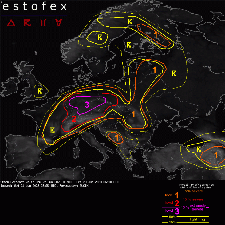
Storm Forecast
Valid: Thu 22 Jun 2023 06:00 to Fri 23 Jun 2023 06:00 UTC
Issued: Wed 21 Jun 2023 23:50
Forecaster: PUCIK
A level 3 was issued across parts of Germany and Czechia mainly for damaging wind gusts, large to very large hail and (regionally) for tornadoes and heavy rainfall.
A level 2 was issued across Switzerland, W Austria and N Italy mainly for very large hail and severe wind gusts.
A level 2 was issued across central Czechia and SW Poland mainly for damaging wind gusts and large to very large hail.
A level 1 was issued across S France mainly for heavy rainfall and large hail.
A level 1 was issued across E Austria, N Hungary, Slovakia and SE Poland mainly for large hail, heavy rainfall and severe wind gusts.
A level 1 was issued across Romania mainly for heavy rainfall and large hail.
A level 1 was issued across Bosnia and Montenegro mainly for large hail and severe wind gusts.
A level 1 was issued across E Estonia, E Latvia, E Lithuania and Belarus mainly for marginally severe wind gusts.
A level 1 was issued across Finland mainly for marginally large hail.
A level 1 was issued across E Turkey, Armenia and Azerbaijan mainly for large hail and severe wind gusts.
SYNOPSIS
A short-wave trough at the mid to upper troposphere will move from Spain towards France and Germany during the day. In response, a surface low will deepen along the waved cold front. The low will translate from France to NE Germany during the forecast period. At Thursday 12 UTC, a cold front will be located in the border area of Germany and France and a warm front will stretch from SE BENELUX through central Germany into Poland. The boundary will turn into a cold front and curve through the Baltic countries into Finland.
A plume of steep mid-tropospheric lapse rates, originating from N Africa, will have overspread the areas with abundant low-level moisture across large parts of Italy, central and southeastern Europe. This overlap will yield an unusually large area with CAPE values exceeding 3000 J/kg, even though the majority of the area will not see any initiation due to the strong capping and lack of forcing. Intense and well-organised storms are expected in the strongly sheared and unstable atmosphere ahead of the short-wave trough and along its attendant frontal system.
DISCUSSION
... Switzerland, Luxembourg, Germany into Czechia and SW Poland ...
*** An outbreak of severe to extremely severe storms is forecast across the area ***
1500 to 4000 J/kg of MLCAPE is forecast to overlap with 20 - 25 m/s of 0-6 km and 15 - 25 m/s of 0-3 km shear. At the same time, scattered to widespread storms are expected to form along either the warm front or the fast-moving cold front that will cross the whole area before Friday morning. Supercells and bow-echoes are forecast with high likelihood of both severe and extremely severe hazards.
The most likely hazard may vary regionally. The highest risk of tornadoes is forecast across W-Central Germany, north of the warm front and near the deepening low. Here, low LCLs will combine with 0-1 km bulk shear > 10 m/s and largely streamwise vorticity in the inflow to the surface-based storms based on the hodograph curvature. Convection-allowing models also simulate supercells with intense rotation and high vorticity tracks in this area. Even strong tornadoes will be possible with the most intense supercells.
The risk of large to very large hail will be the highest in the early stages of the scenario (given more isolated nature of storms) and in the areas with highest concentrations of buoyancy in the cold part of the cloud, which will be the areas more in the south of the Lvl 3 or Lvl 2. Very large hail may be the dominant risk over Switzerland, extreme N Italy or NW Austria.
Severe wind gust risk will ramp during the afternoon hours. Even along the warm front, some of the models show an upscale growth of supercells into bow-echo. The highest risk of severe winds will be more south though, where well-mixed boundary layer is forecast with LCLs up to 2 km and a high potential for strong cold pools. Given that, strong 0-3 km shear and widespread linear lift from the accelerating cold front, there is a very high probability of one or more bow-echoes developing in this setting. The most likely corridor of severe to extremely wind gusts will be SW Germany - NW Czechia.
Heavy rainfall risk will be most pronounced to the NW of the surface low, where strong frontogenetical lift will combine with some elevated CAPE.
... E Austria, Slovakia, N Hungary, SE Poland ...
Isolated to widely scattered storms are forecast to form, forced by an orographic lift. Given around 15 m/s of 0-6 km bulk shear, well organised multi or even supercells are forecast with threats of large hail, isolated severe wind gusts or heavy rainfall. Higher coverage of severe could result from the effect of the overnight or afternoon/evening convective systems and their cold pools that would travel to the area from W/NW. Such a possibility needs to be evaluated during the morning forecast and in the nowcasting setting.
... Romania ...
Scattered to widespread storms are forecast, especially over the Carpathians. Expect predominantly flash flood and large hail risk in stronger multicells.
... Belarus, E Baltics ...
A trough with an ill-defined cold front will move over the region. Scattered storms will form and possibly form one or several short linear segments along the front. Short hodographs will limit storm organisation and only skinny CAPE profiles are forecast. A marginal Lvl 1 is issued for marginally severe wind gusts as the linear segments move E, where higher LCLs may allow for a stronger cold pool and 0-1 km shear is forecast to increase locally to 10 m/s.
... Bosnia to Montenegro ...
A questionable Lvl 1 is issued for a very high CAPE environment with moderate shear. Some models produce weak convective precipitation signals, suggesting initiation over the mountains. Abundant buoyancy and high LCLs suggest large hail and downburst risks.
... Finland ...
Hodographs suggest that at least multicells will be able to form along a weak frontal boundary. Marginally large hail may occur given sufficient buoyancy in the cold part of the cloud.
... E Turkey, Armenia, Azerbaijan ...
Organised storms will form in the environment of high LCL and buoyancy concentrated in the cold part of the cloud, resulting in a threat of large hail or severe gusts. The flash flood risk will increase towards N and W, where the shear decreases along with the strength of the mean wind, rendering slower-moving storms.