
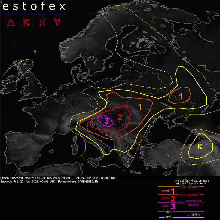
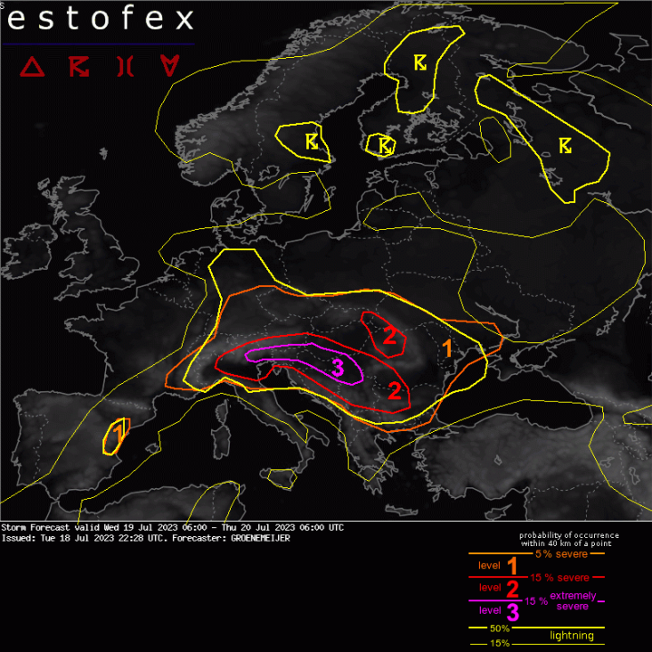
A level 3 was issued across far southeastern Austria, southwest Hungary, eastern Slovenia and northern Croatia for damaging wind gusts, very large hail, and to a lesser extent for very heavy rainfall.
A level 2 was issued across the northwestern and central Balkans and Hungary for very large hail and severe wind gusts and to a lesser extent for very heavy rainfall.
A level 1 was issued across an area surrounding the level 2 areas for the same hazards.
SYNOPSIS
A cut-off low is expected to develop across the northern Adriatic Sea from a trough initially with an axis from northeast Germany to Italy. An extremely unstable air mass is in place across the western Balkans and Hungary with MLCAPE in the 2000-4000J/kg range. A round of severe storms is expected to develop today as the capping inversion gradually erodes sufficiently to allow for initiation.
DISCUSSION
Austria, Western Balkans, SW Hungary...
Storms are expected to initiate over the southeastern Alps during the afternoon. MLCAPE around or above 2000 J/kg and strong 15 m/s bulk shear in the 0-3 km layer suggest that updrafts may become very powerful and produce very large hail well in excess of 5 cm. With a predicted LCL height of about 2.0-2.5 km ample strong hydrometeor evaporation below cloud base is expected. This should aid the formation of a bow echo moving southeastward into Slovenia, Hungary, Croatia, and later possibly into Serbia and Bosnia. As this happens, the main threat should transition to very strong wind gusts. Ahead of this system, scattered initiation of cells - most prominently off the Dinaric Alps - is expected as well. Profiting from up to 4000 J/kg of MLCAPE, these cells will be able to produce very large hail as well, along with isolated strong downbursts.
Slovakia, Hungary, Western Romania...
Another likely focus for convective initiation will be the southern Tatra mountains. It is expected that isolated storms, that develop into a very unstable air-mass with 3000 J/kg MLCAPE and moderate 10 m/s 0-3 km km bulk shear, will merge along a common outflow boundary and propagate south to southeastward into the eastern Pannonian Plain and western Romania. Initially, the main risk of these storms will be very large hail and isolated downbursts, while this will gradually change to mostly a substantial risk of strong wind. Any cells developing in isolation, however will continue to have a risk of very large hail.
Southwestern Russia and northern Ukraine...
In vicinity of a subtle frontal wave, a number of convective storms are expected to occur in an environment with modest (500-1000 J/kg) MLCAPE, but substantial low-level shear and rather curved low-level hodographs. This suggests some risk of tornadoes and severe wind gusts will exist. In addition a modest risk of large hail will exist with any well-organized supercell that manages to form.
https://www.estofex.org/cgi-bin/polygon/showforecast.cgi?text=yes&fcstfile=2023070606_202307042255_3_stormforecast.xmlStorm Forecast
Valid: Wed 05 Jul 2023 06:00 to Thu 06 Jul 2023 06:00 UTC
Issued: Tue 04 Jul 2023 22:55
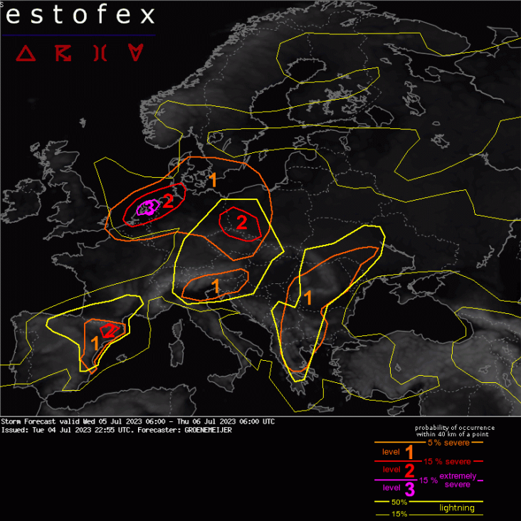
Forecaster: GROENEMEIJERA level 3 was issued over the NW Netherlands mainly for severe wind gusts and to a lesser extent for tornadoes and heavy rainfall.
A level 2 was issued across the Netherlands and northwest Germany for severe wind gusts, heavy rainfall and to a lesser extent for tornadoes.
A level 2 was issued for parts of Northeast Spain mainly for large hail.
A level 2 was issued across Czechia, East Germany, and Southwest Poland for all hazards.
A level 1 was issued across extreme northern France, Belgium, a large part of North and Central Germany, Poland, Czechia, and Austria for severe wind gusts and across Czechia, eastern Germany and Poland to a lesser extent for tornadoes and large hail.
A level 1 was issued across the southern Alps and north Italy mainly fo large hail and local heavy rainfall.
A level 1 was issued over East Spain mainly for large hail.
A level 1 was issued across the central and eastern Balkan Peninsula mainly for heavy rainfall, and to a lesser extent for large hail.
SYNOPSIS
An intense mid-level vorticity maximum that has transitioned into a closed circulation across the southern North Sea moves to Southwest Sweden. It is associated with a surface low that rapidly develops in the 00 - 12 UTC timeframe producing widespread extreme wind gusts across the level 2 area. A cold front moves quickly eastward across Germany into Poland and southern Sweden. Further south, moderate westerly flow affects the Alpine region and the central Mediterranean, setting the stage for a few more severe hailstorms as CAPE builds diurnally. Across Spain, mid-level flow is markedly stronger, leading to stronger wind shear. Storm coverage is isolated, but may be scattered to widespread in vicinity of the Pyrenees, where a level 2 appears to be warranted. Across the Central and eastern Balkans, flow is much weaker. Abundant humidity and fairly steep lapse rates suggest a risk of local severe weather there.
DISCUSSION
Benelux, Germany, and surrounding regions...
At 22 UTC Wednesday IR/water vapour satellite imagery is consistent with the consensus of the numerical weather prediction models that calculate the rapid development of a small surface cyclone across the southern North Sea ahead of a strong mid/upper-level vorticity maximum. The models suggest that a line of thunderstorms will move north-eastward along a cold front across northern France into the Benelux and Germany prior to the forecast period. Along this front, the strong background wind field and strong low-level shear suggests that sever wind gusts may occur along with a risk of short-lived tornadoes along it. The front should be near a line from Bremen to Frankfurt am Main around 06 UTC.
Further west, across the southern North Sea and the Netherlands a back-bent/instant occlusion will form with associated sting-jet like wind maxima with local wind gust speeds on the order of 30 - 35 m/s, and locally higher. As the cyclone is filled with surface-based and elevated convective elements with isolated lightning, we will consider all wind gusts to be within scope of this ESTOFEX forecast. We estimate the risk of extreme gusts of more than 32 m/s large enough to warrant a level 3 for the region most at risk.
Within subsequent ICON-D2 model runs some members show intense, rotating, convective cells embedded within the developing back-bent occlusion over the Netherlands during the 4 UTC - 10 UTC time frame, that could create localized very severe wind swaths with gusts over 40 m/s, this scenario not being supported by other convection-allowing models. A risk of such extreme gusts and tornadoes cannot be ruled out though. As the cyclone matures, the severe westerly winds on the southern flank will translate north-eastward across northwestern Germany.
Central and eastern parts of Germany, Czechia, W Poland...
Along or just ahead of the eastward-moving cold front, new storms are expected to develop during the afternoon. They do so in an environment with adequate CAPE and approximately 20 m/s of deep-layer shear, suggesting that some may become supercells with a risk of large hail and severe wind gusts. Locally, in particular over Czechia, heavy rainfall is an additional notable hazard. Storms that manage to form during the morning ahead of the front will do so in an environment that exhibits higher low-level helicity. As a result, an isolated tornado cannot be ruled out. NWP models suggest that such conditions are most likely near the Polish/Czech border and far northwest Poland.
Southern Czechia, Austria...
Wind shear is lower here than further north, so that less storm organization is expected. Nevertheless, heavy rainfall and possibly some local marginally large hail are possible.
Southern Alps...
Although deep-layer wind shear is relatively modest, 15 m/s may be adequate for some multi- and supercells that, courtesy of the 1000-2000 J/kg of MLCAPE will bear a risk mostly of large hail, and to a lesser extent of heavy rainfall and local severe winds.
Eastern Spain...
Isolated storms are expected to develop once again across the mountain ranges of eastern Spain. Some light forcing for upward motion is expected to increase storm coverage across far northeastern Spain. Since CAPE should be adequate with about 1000 J/kg MLCAPE and deep-layer shear is strong with 25-30 m/s winds, some of them will be able to produce large, and possibly very large (5 cm or more) hail. In addition, a more limited risk of very heavy rainfall will exist.
Balkans...
Across the indicated areas of the Balkans, the flow is weak but moisture abundant, which in combination with fair lapse rates should yield widespread 1500-2500 J/kg CAPE. Storms are expected to form in response to solar heating, and should in spite of the weak wind shear be able to produce heavy rainfall, and locally large hail. Given strong low-level buoyancy an isolated spin-up tornado cannot be ruled out.
Eddy.
A level 3 was issued across central-E France, NW Switzerland and SW Germany mainly for severe to extremely severe wind gusts and very large hail.
DISCUSSION
... S France through Switzerland, the Alpine range and S Germany ...
*** Very large hail and several swaths of severe to extremely severe wind gusts are forecast across the area ***
Models are in good agreement concerning the evolution of 1500+ J/kg of MLCAPE (locally even 3000+ J/kg) across S France, Massif Central, NW Switzerland, and N Italy thanks to the steep mid-tropospheric lapse rates. CAPE will overlap with strong vertical wind shear, which will increase towards the evening hours and will decrease from W to E. Across the Massif Central, models simulate around 25 m/s of 0-6 km and 20 m/s of 0-3 km shear. Initiation is expected in the afternoon hours due to the orographic lift as the front will still be far W. First storms will rapidly become supercells with almost certainty of large hail occurrence. Given substantial amounts of CAPE in the hail growth zone and rather straight and very long hodographs, 8+ cm hail may occur in the strongest storms.
The highest severe weather risk will be due to the severe to extremely severe wind gusts. High-resolution, convection-allowing, models consistently show one or more swaths of severe wind gusts across the area, including pockets of gusts exceeding 32+ m/s. The exact track with the most intense gusts is not clear. With the lack of strong linear forcing, the upscale growth of convection will depend on details such as storm mergers of individual supercells. Upscale growth will be supported by progressively deeper boundary layer towards E with Inverted-V profiles and high potential for strong cold pools.
While some of the models show an increase in the low-level SRH towards the evening hours across E France and SW Germany, the predominance of linear convective mode and high LCLs may hinder the tornado threat. This threat needs to be monitored especially if isolated supercells manage to persist into the late evening hours.
Lvl 3 is introduced for the area with the anticipated highest likelihood of extremely severe weather (very large hail in the W and extremely severe wind gusts in the E). Lvl 2 covers also parts of N Italy, where some of the models depict an evolution of supercells or another system with severe wind gusts in the late night to early morning hours. The severe weather threat would be very high given the degree of CAPE/shear overlap.
Storm Forecast
Valid: Wed 12 Jul 2023 06:00 to Thu 13 Jul 2023 06:00 UTC
Issued: Wed 12 Jul 2023 00:04
Forecaster: GROENEMEIJER
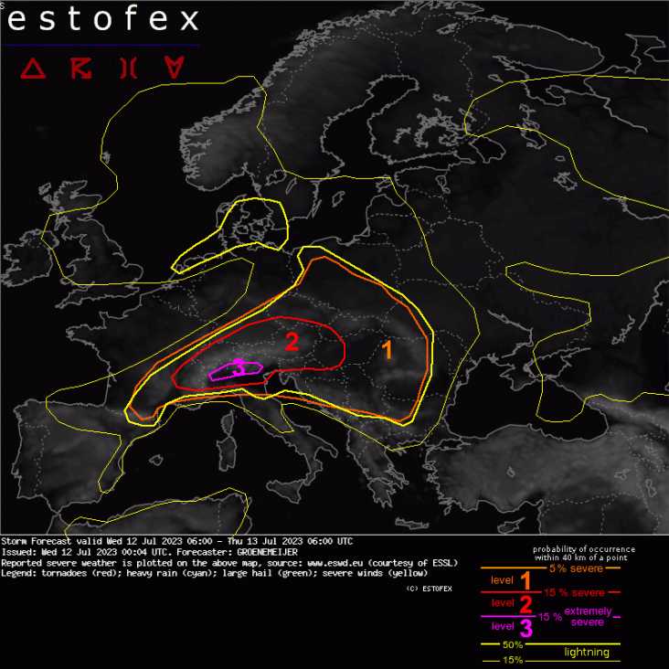
A level 3 was issued across northwest Italy and far southern Switzerland mainly for very large hail, and to a lesser extent for severe wind gusts, very heavy rainfall and tornadoes.
A level 2 was issued across the Alps and their vicinity for large and very large hail, damaging winds, and for very heavy rainfall.
A level 1 was issued across an area surrounding the level 2 for large and very large hail, damaging winds, and for very heavy rainfall.
SYNOPSIS
A ridge with an axis initially from the Baltic Sea to the northwestern Balkans moves eastward to reach a line from Lithuania to Romania by Thursday morning. Upstream a strong southwesterly flow in the mid- and upper troposphere creates a strongly sheared environment that stretches across the Alpine region where a diffuse cold front moves slowly moves southeastward. Together with moderate instability on the northern forelands, and high instability on the southern, this sets the scene for another round of severe storms. Further south, the air-mass is capped by a deep elevated mixed layer.
Level 2 area...
Numerical weather prediction models suggest that little quasigeostrophic forcing for upward motion will affect the area during the day. Hence, lift will be primarily created by mesoscale processes. These will include orographically induced circulations and upward motion along low-level boundaries. Convection-allowing models suggest that diurnally created upslope flow will lead to convective initiation across the Alps and its northern, eastern, and southern flanks at several locations as well as downstream of the Massif Central and other lower mountain ranges. Pinpointing the locations is complicated, however initiation should be widespread. The environment, however, is clearly supportive of severe weather including supercells with a risk of large hail and severe winds.
Convection-allowing models suggest that storms will initiate by late morning or early afternoon and may soon grow upscale posing a threat of severe and locally extreme (>32 m/s) wind gusts downstream across much of Austria, South Tyrol, and possibly into adjacent countries such as Slovakia, Hungary, and Slovenia. However, this scenario is not supported by all models and hence not enough confidence is present to issue a level 3. Besides the wind threat, these storms will be capable of producing large to very large (> 5 cm) hail and locally very heavy rainfall.
Across far southeastern France, northwest Italy, and southern Switzerland more certainty exists that one or multiple rounds of storms will develop. As they do, they will encounter particularly strong 1-3 km shear that suggests strong storm-relative inflow and particularly vigorous updrafts in a high-CAPE environment, at least across southern Switzerland and northwest Italy. This is ideal for storms producing very large hail of 5 cm or possibly even 10 cm in diameter. Furthermore, severe winds and very heavy rainfall are important risks. As a result, a level 3 was issued for this area.
Across Northeastern Italy and Slovenia, there is high confidence that convective storms will spread to the lowlands during the late evening, into an environment where wind shear has substantially increased to nearly 20 m/s in the 0-3 km layer and abundant CAPE. These storms are likely to include some very severe hailstorms as well with an attendant wind and heavy rain risk.
Across Southern France, northern Switzerland, and southern Germany, shear will be as strong, but CAPE a little lower. Still, this should be more than sufficient to sustain very large hail of 5 cm or larger, locally damaging winds, and severe wind gusts.
West and Central Poland...
Remnants of an elevated mixed layer will be removed across Poland during the day as cooler air flows in from the west. In an environment of moderate CAPE and moderate wind shear, a few organized storms may form, including short-lived supercells with a risk of large but likely not very large hail, and possibly some heavy rain.
Southeast Poland, East Slovakia, East Hungary, Northwest Romania, extreme southwest Ukraine...
In a warm air advection regime across the region, both the ECMWF and GFS models suggest that an intense convective system may develop that translates along the warm from Poland to Romania. Given that 15-20 m/s of deep-layer shear are in place, an organized system seems well possible. That said, moderate CAPE of about 1000 J/kg, and some uncertainty about whether it will actually develop reduce the confidence to an extent that a level 1 seems adequate.
Storm Forecast
Valid: Wed 19 Jul 2023 06:00 to Thu 20 Jul 2023 06:00 UTC
A level 3 was issued across parts of Italy, Austria, Slovenia, Hungary, Croatia, Bosnia and Serbia, firstly for very large hail and damaging winds, and secondly for very heavy precipitation.
A level 2 was issued for the same hazards across an area surrounding the level 3.
A level 2 was issued for eastern Slovakia, central Romania, and eastern Hungary for large hail, very heavy rainfall, and to a lesser extent for tornadoes.
A level 1 was issued across an area surrounding these level 2 areas, for heavy precipitation and large hail.
A level 1 was issued across eastern Spain for a risk of severe downburst winds, and, very locally, large hail.
SYNOPSIS
A strong zonal jet streak is located across central Europe at the northern fringe of a pronounced elevated mixed layer. The combination of the associated steep lapse rates and ample low-level humidity across Po Valley and the northwestern Balkans lead to very high MLCAPE in a zone from Serbia through the northwestern Balkans, with values of 2000-3000 J/kg, into the Po Valley, where values in the 3000-5000J/kg range are predicted. A high-end severe weather situation with very large hail and widespread severe winds is expected to develop as a subtle upper-level vorticity maximum moves into the region, setting the stage for convective initiation of this volatile environment.
DISCUSSION
Alpine region, Pannonian Plain, and the northwestern, western and central Balkans...
NWP models suggest that on Wednesday morning scattered rapidly-moving elevated storms may be ongoing across the large level 2 area. Forecasting their locations and intensity is very difficult even 6 to 8 hours ahead. Although these storms pose some risk of severe winds and large hail, their elevated nature limits this risk, and stronger storms are expected to develop later in the day.
During the afternoon, as the aforementioned vorticity maximum approaches the Alps from the west, per all NWP guidance, widespread initiation is expected across the southern and central Alps. The storms will do so in a very unstable and strongly sheared environment, so that rapid evolution into supercells, followed by a transition to one or more bow echoes is expected. Additional storms could form across the Dinaric Alps, and possibly across the Po Valley as parcels are lifted ahead of outflow boundaries from the Alps.
The very high instability and strong storm-relative low-level wind in this environment suggest that some storms will likely produce very large hail in the 5-10 cm range. The transition in a bow echo is expected during the evening as the storms move across the northwestern Balkans, and possibly Hungary. Widespread severe winds are expected as a result, including some extremely severe winds of more than 32 m/s. Overnight, the system should very gradually diminish in intensity as an environment with lower CAPE is encountered across southern Serbia, Romania, and Bulgaria.
Slovakia, eastern Hungary, West Ukraine, Northwest and Central Romania...
Storm initiation is expected as a subtle frontal wave with some warm advection provides additional lift across this section of the Carpathian and Abuseni mountains. With moderate CAPE and fairly strong wind shear in place, some of the storms that develop in response will likely become severe. They include supercells with a risk of large hail and very heavy rainfall. In addition, the warm advection creates amounts of low-level storm-relative helicity that may be adequate for one or two tornadoes to develop with the highest risk located across Central Romania.
East Spain...
A few storms may form across the mountains of eastern Spain in response to the diurnal strengthening of the inland and upslope flow. Given the very deep and dry boundary layer, strong evaporational cooling suggests a risk of downbursts with any stronger storm. Given high CAPE and 20 m/s of deep-layer shear, some large hail is possible as well.
Storm Forecast
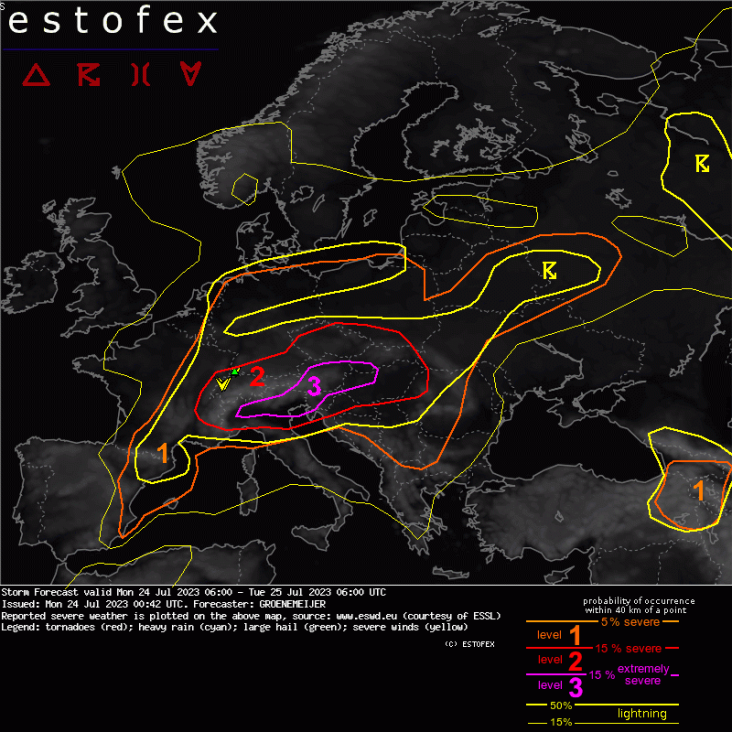
Valid: Mon 24 Jul 2023 06:00 to Tue 25 Jul 2023 06:00 UTC
Issued: Mon 24 Jul 2023 00:42
Forecaster: GROENEMEIJER
A level 3 was issued across Austria, Northwest Hungary, and western Slovakia mainly for damaging winds and very large hail, and to a lesser extent for very heavy rainfall.
A level 3 was issued across northern Italy, northern Slovenia, and extreme southern Austria for very large to giant hail, damaging winds, and tornadoes, and to a lesser extent for very heavy rainfall.
A level 2 was issued across a larger area surrounding the level 3 for all hazards, particularly large hail, and severe wind.
A level 1 was issued across a large part of Europe, for isolated large hail, severe wind gusts, and heavy rainfall.
A level 1 was issued across parts of eastern Turkey, Georgia, Armenia, and Azerbaijan, primarily for large hail.
SYNOPSIS
At the anticyclonically curved northern edge of a deep elevated mixed layer across the Central Mediterranean region, the mid-/upper-level flow is strong. A shortwave trough with an axis from southern Britain to NW Spain slowly translates eastward and tightens the height gradient a little further, creating very strong shear. Subtle impulses for upward motion traveling along the edge will be the focus for a few rounds of storms, that in combination with moderate to very high CAPE will likely produce widespread severe or extremely severe weather including all convective hazards: damaging winds, very large hail, tornadoes, and heavy rainfall.
DISCUSSION
Level 2 region from France to Switzerland, southern Germany, Czechia, Austria, Poland, Slovakia, Hungary, and Romania...
A nocturnal thunderstorm cluster that developed across France in response to frontogenetic forcing should be located approximately across Switzerland by the start of the forecast period. Ahead of it, considerable CAPE will develop across and near the Alps with values of 1500 - 2000 J/kg across the lower terrain of Austria.
A rapid increase in storm coverage and evolution into an eastward racing bow-echo is anticipated. Initially, large to very large hail will a big risk, but this should fairly quickly transition to wind. With embedded supercells, large hail will still remain a possibility, though. This transition is accelerated by strong evaporational cooling in the deep boundary layer to the north of the Alps and the particularly strong 0-3 km bulk shear of 20 - 25 m/s along the central Alps. Most convection-allowing models simulate a long swath of severe winds from western Austria into Slovakia and Hungary, including locally extremely severe winds > 32 m/s. The storm system may well continue eastward across the Pannonian Plain and ultimately reach northwest Romania. A scenario whereby new storm cells develop across Hungary, or several intense bow echoes move from Slovenia and/or Southern Austria across Hungary towards and into Romania is also suggested by some models.
Further north, across Southeast Germany, Czechia and southern Poland, linearly organized convection may form as well, however with a somewhat lower intensity than further south. Nevertheless, severe winds are also possible in this region. In the wake of they first storms, more storms are expected to develop across eastern France, Switzerland and southern Germany. These will develop in an environment with fairly low (~ 1000 J/kg) MLCAPE, but strong linear deep-layer shear of around 25 m/s. These storms may produce some large, but not extremely large, hail and locally severe winds. The storm activity will likely continue overnight.
North Italy, southern Switzerland and Austria, Slovenia, Croatia...
Within this second area of risk, supercells are expected to develop during the afternoon across the Alps. These do so in an environment of 25 m/s shear in the 0-3 km layer only which will boost their organization and vigor. Large to very large hail in combination with severe winds will create a high damage potential with these storms that may transition into small bow echoes over time.
During the evening, the temperature in the 800-500 hPa level will start to drop from the west, facilitating the movement of storms to the lower terrain. This is the point where the strongest storms are simulated by the convection-allowing models, such as ICON-D2, which shows among the most intense updraft helicity tracks seen in this model. This can be understood by the high 2000 - 4000 J/kg of MLCAPE, and the extreme high shear. These storms will be capable of producing very large (5 - 10 cm) to giant (> 10 cm) hail in some places, extreme severe winds gusts, as well as wind-driven hail, the very damaging combination of the two.
The predicted low-level wind profiles are not very favorable for tornadoes per se, as the wind shear in the lowest kilometre, or even lowest 500 metres, is limited, and mostly not streamwise. But as rare past cases have shown, in such an exceptional high-CAPE/high-deep-layer-shear situation, tornadoes or even strong tornadoes are well possible.
A first round of storms is forecast to affect the low land of Northern Italy and subsequently the northern Adriatic and finally Slovenia and/or northern Croatia during the evening and early night. Afterwards, stabilisation will gradually and temporarily reduce the risk of such extreme storms, however, additional elevated storms with primarily a risk or large to very large hail may continue during the night, in particularly across Italy, and affect areas slightly further south, i.e. Liguria, Emilia-Romagna, and northern Tuscany.
Benelux, Northeast France, North Germany, Northwest Poland...
As some 500 - 1000 J/kg of CAPE should develop within a fairly strongly sheared flow (20 - 25 m/s 0-6 km bulk shear), convective storms that evolve in this weakly capped environment should organize into small supercells or lines. Given the high buoyancy close to the lifted condensation level that is predicted and fair low-level shear, a few short-lived tornadoes cannot be ruled out. In addition, some very local severe wind gusts may also evolve as well as isolated marginally severe hail (2-3 cm).
East Spain...
With a short time window ahead of a surge of cooler, drier air from the northwest, the capping inversion atop the warm, moist boundary layer should erode and a window for possible deep convection should exist across the area and even, possibly, along the coast or sea. Given the high CAPE and shear, there is a risk that a potential storm would become severe and produce large hail, very heavy rainfall, and/or strong winds. A level 1 was issued for this low but existing risk.
Belarus, adjacent Russia...
An environment of limited (400-800 J/kg) CAPE and moderate deep-layer shear also exhibits fairly short but curved low-level hodographs. This suggests that some stronger low-level mesocyclones may develop with a risk of a tornado or two, and possibly some marginally severe hail.
Eastern Türkiye and adjacent countries...
Rather steep mid-level lapse rates, i.e. between 700 and 500 hPa in this region enhance the risk of hail by providing additional buoyancy and updraft strength. This elevates the risk of large hail to where a level 1 is clearly warranted.
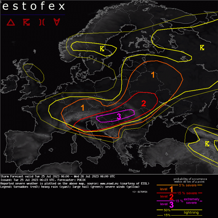
Storm Forecast
Valid: Tue 25 Jul 2023 06:00 to Wed 26 Jul 2023 06:00 UTC
Issued: Tue 25 Jul 2023 06:23
Forecaster: PUCIK
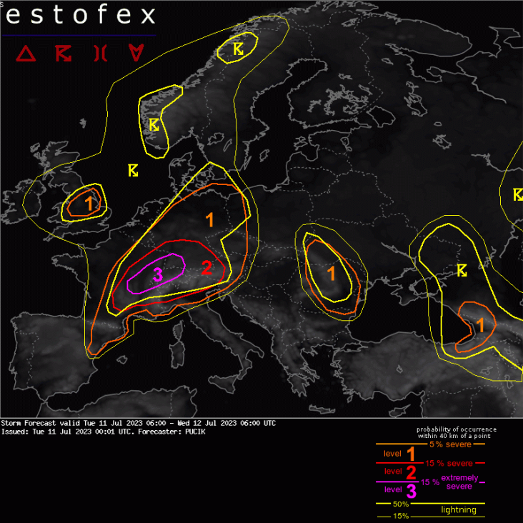
A level 3 was issued across Slovenia, N Croatia, S Hungary and W Romania mainly for damaging wind gusts, very large hail and to the lesser extent for tornadoes.
A level 2 was issued across N Italy mainly for very large hail, severe wind gusts and tornadoes. A strong tornado threat will be present along the Apennines!
A level 2 was issued across N Hungary, E Slovakia, Ukraine and N Romania mainly for damaging wind gusts, large hail and excessive rainfall.
A level 1 was issued across Belarus and W Russia for tornadoes, severe wind gusts and to the lesser degree for large hail.
A level 1 was issued for E Latvia and Lithuania mainly for heavy rainfall and marginally large hail.
*** Severe weather outbreak continues with the threat shifting further east during the day! ***
DISCUSSION
... Slovenia, N Croatia, S Hungary, NW Romania ...
A band of intense storms has entered Slovenia from N Italy. The environment ahead is characterized by >1500 J/kg of MUCAPE combined with very strong effective shear. The storms will pose a risk of very large hail. Severe wind gusts are likely despite the fact that storms may be elevated at first. As the storms move E, daytime heating over Hungary may allow for the storms to become surface based. A development of bow echo is possible given 20+ m/s of 0-3 km shear. Extremely severe wind gusts threat will thus increase towards the later hours as the system moves towards Romania. Some forecast hodographs also show around 10 m/s of 0-1 km shear and large amounts of streamwise vorticity in the inflow to the storms. This threat will be conditional upon the convective mode and whether the surface heating will allow the cloud bases to become higher.
... N Italy ...
While the main line of storms has passed towards E, high-res models still indicate a development of more isolated storms, supercells, especially along the Apennines. Will maintain a Lvl 2. Shear profiles will remain extremely conducive for supercells capable of all hazards, but increasing dryness in mid-troposphere may inhibit the activity later on. A tornado risk will be present especially along the W flank of the Apennines, where models show 10+ m/s of 0-1 km bulk shear and 150 m2/s2 of 0-500 m SRH. If an isolated supercell moves across the region, a strong tornado risk can be expected in such an environment.
... N Hungary, Slovakia, Ukraine, ...
Widespread storms are forecast to form across the area in MLCAPE around 1000 J/kg (increasing towards S) and 15 - 20 m/s of 0-6 km bulk shear. Well organised storms are forecast to form, including supercells and large convective systems, that will move NE. Ukraine may be affected by a fast-moving convective system that will emerge from Ukraine. Expect multiple threats from storms, including large hail, severe wind gusts and heavy rainfall.
... Belarus to W Russia ...
ICON-EU shows large curve in the low-level hodograph, suggestive of a tornado threat over this region. Other models are more sceptical and the area needs to be monitored for the development of supercells. More marginal severe wind gust and large hail risk would be present besides this one.
... S Germany, Alps, SW Czechia ...
Ahead of the approaching short-wave trough, along the front, scattered to widespread storms are forecast to form, in the environment of MLCAPE up to 1000 J/kg and 0-6 km shear of around 15 m/s. Expect risks of large hail and isolated severe wind gusts from stronger storms, couple of which could be supercells.
... E Latvia and E Lithuania...
Forecast profiles show around 15 m/s of 0-6 km shear, allowing for at least well-organised multicells and brief supercells not being ruled out. In such scenario, marginally large hail may occur, which is otherwise limited by skinny CAPE and low LCLs. Heavy rainfall threat will be present in multicells, especially if multiple cells cross the same area, given high RH throughout the whole troposphere.
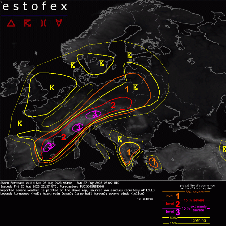
Storm ForecastStorm Forecast
Valid: Sat 26 Aug 2023 06:00 to Sun 27 Aug 2023 06:00 UTC
Issued: Fri 25 Aug 2023 22:37
Forecaster: PUCIK/KUZMENKO
A level 3 was issued for Catalonia and extreme NE Spain mainly for very large hail, damaging wind gusts, heavy rainfall and tornadoes.
A level 3 was issued across NW Italy mainly for very large hail, damaging wind gusts, heavy rainfall and to the lesser degree for tornadoes.
A level 3 was issued across SE Germany and NW Austria mainly for damaging wind gusts, large to very large hail and to the lesser extent for heavy rainfall and tornadoes.
A level 2 was issued across SE France mainly for heavy rainfall, large hail and to the lesser extent for tornadoes and severe wind gusts.
A level 2 was issued across S and E Czechia mainly for heavy rainfall, severe wind gusts and large hail.
A level 2 was issued across S Poland and N/NW Slovakia mainly for large to very large hail, severe wind gusts and heavy rainfall.
A level 1 was issued across Poland, Lithuania, W Belarus, NW Ukraine mainly for heavy rainfall, large hail and isolated severe wind gusts.
A level 1 was issued across Greece, Northern Macedonia, S Albania mainly for large hail and heavy rainfall.
A level 1 was issued across SW Turkey mainly for large hail and severe wind gusts.
SYNOPSIS
At mid to upper troposphere, main synoptic-scale feature will remain to be a deep cyclone centered over the UK. On its forward flank, strong flow is forecast, exceeding 25 m/s at 500 hPa. Base of the trough will rotate across Iberia towards the Mediterranean Sea, providing strong synoptic-scale lift over the region. Towards the surface, a pronounced wavy cold front will run from Spain through SE France, the Alpine Region into Czechia, Poland and the Baltic Sea. A warm front will run from Estonia towards W Russia. The frontal boundary will lift NE-wards during the day. Widespread thunderstorms, including isolated to scattered severe storms, are forecast along and ahead of the cold front, where abundant low-level moisture is present. Further storms are forecast under a cut-off low centered over S Greece.
DISCUSSION
*** An outbreak of severe thunderstorms is expected across a large area from E Spain to Poland. Catalonia, NW Italy and SE Germany/ NW Austria will be under the highest probability of extremely severe thunderstorms ***
... NE Iberia, Balearic Sea ...
MLCAPE values well above 2000 J/kg and 0-6 km/0-3 km bulk shear above 25/20 m/s will create conditions very favorable for intense and well-organised storms, including bow-echoes and supercells. The first storms will be initiated by orographic lift and coverage is forecast to increase rapidly towards the evening and night hour as the cold front and the short-wave trough approach. All severe weather hazards will be possible, very large hail and damaging wind gusts perhaps the most pronounced ones. Some models show window of opportunity for tornadoes with increasing low-level shear and storm-relative helicity towards the evening hours along the coastline before the storms become elevated. During the nighttime, the dominant type of severe weather threat will shift more towards the heavy rainfall. Severe storms will then spread SE-wards, possibly reaching the Balearic Islands with very large hail and damaging wind hazards.
... SE France ...
Multiple rounds of (severe) thunderstorms are forecast across the region. During the afternoon hours, more isolated storms, including supercells will be possible across the area, posing threats of large hail and severe wind gusts. Convective coverage will increase rapidly towards the night as the cold front crosses the area. Substantial MUCAPE will be present inland and combined with moist profiles will lead to high rainfall rates. Persistent and rainfall efficient storms may locally produce very high rainfall amounts, even well above 100 mm. Tornado threat will be present along the coastline, where low LCLs will combine with 0-1 km shear exceeding 10 m/s, curved hodographs and at least some SBCAPE.
... N Italy ...
Across NW Italy, models unanimously agree on MLCAPE exceeding 2000 J/kg, combined with 0-6 km bulk shear above 25 m/s. Multiple intense supercells are forecast to initiate across the W Alps by high-resolution models and move NE-wards across the lowlands with risks of very large hail and severe wind gusts. An upscale growth is likely towards the evening hours, especially near the mountains, with an increase in damaging wind gusts and heavy rainfall risk. An increase in low-level shear is forecast towards the evening hours, yielding a tornado threat before the storms become elevated.
... SW Germany, N Austria, Czechia ...
High-resolution models agree on the development of intense supercells along the N Alpine rim in the environment of MLCAPE around 1500 J/kg and 0-6 km shear up to 30 m/s. These supercells will pose threats of very large hail and damaging wind gusts. It's likely that the storms will grow upscale as they move E towards Austria and Czechia, increasing the risk s of severe wind gusts and heavy rainfall even further. Between 15 and 18 UTC, models simulate an increase in the low-level shear and hodograph curvature across N Austria, increasing the risks of tornado, especially if isolated supercells will still be present at that time. After that, the storms will move further NE into Czechia and S Poland, where higher LCLs will allow for maintenance of severe wind gust risk despite substantially weaker CAPE compared to N Austria and SW Germany, at least initially. Heavy rainfall is also likely locally with abundant elevated storms forming just W of the frontal boundary. Elevated storms, including supercells, will be possible through the night, posing the risks of large hail and perhaps isolated severe wind gusts as the MUCAPE is forecast to increase across the extreme E Czechia.
... Slovakia, Poland ...
The highest severe weather risk is forecast in the afternoon to late afternoon hours with storms forming across the Carpathians and spreading into the lowlands of S Poland. Well-organised multi or supercells are forecast with threats of (very) large hail and isolated severe wind gusts. At the same time, isolated to scattered storms are also possible further N and NW. However, these storms will form in lower CAPE-shear overlap and will pose lesser risk. Further storms are expected in the evening and overnight, likely connected to large convective system arriving from Austria and Czechia. Severe wind gusts, heavy precipitation and also isolated large hail threats will persist through the night.
... Greece, Northern Macedonia, S Albania ...
Isolated to scattered storms will be initiated by orography during the early afternoon hours. Substantial CAPE below -10 deg C isotherm along with 0-6 km bulk shear around 15 m/s point to the threat of large hail across the area. Slow-moving storms may also locally pose threat of heavy rainfall.
... W Turkey ...
Isolated storms are forecast to form in the afternoon with threats of large hail, due to the substantial CAPE in the cold part of the cloud and severe wind gusts, due to the Inverted-V profiles.
Storm Forecast
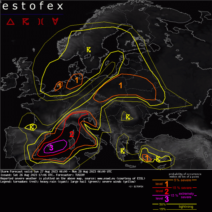
Valid: Sun 27 Aug 2023 06:00 to Mon 28 Aug 2023 06:00 UTC
Issued: Sat 26 Aug 2023 17:06
Forecaster: TUSCHY
A level 3 was issued for the Balearic Islands mainly for multiple rounds of all kind (extreme) severe events, including significant tornadoes, damaging winds and excessive rain.
A level 2 extends from SE Spain to the Alps with varying potential for significant severe. Corse/Sardegna with damaging winds/large hail turning more into an excessive rain/tornado threat over NW Italy.
A level 1 was issued for a belt from Czechia to Poland into the N-Ukraine mainly for excessive rain, wind and hail. An isolated tornado is possible mainly over CNTRL/NE Poland into SW Belarus.
A level 1 was issued for NW Germany and parts of the Netherlands mainly for an isolated tornado event (Germany) and heavy rain (the Netherlands).
A level 1 was issued for SW Turkey mainly for isolated large hail/severe wind gusts.
SYNOPSIS
An anomalous trough over W Europe becomes the main driver for this severe weather outbreak. The main energy drops south into a sharp upper trough configuration, which shifts its tilt from positive to negative during this forecast while crossing the W Mediterranean. Its 500 hPa geopotential height anomaly is rather impressive for this time of year. Even more impressive is the low/mid-tropospheric pressure response with a rapidly deepening low. ECMWF brings this depression to record level over the Ligurian Sea during the end of the forecast with similar results of GFS. This evolving depression pushes a cold front from the W to the CNTRL Mediterranean.
The northern part of this trough evolves into a lower amplitude wave, which crosses N Germany during this forecast period.
East of this trough configuration a wavy frontal bounday extends from the Italian depression NE towards Poland, where IFS-ENS agrees nicely in another evolving/weak depression.
Overall NWP guidance agrees well in this setup with ongoing manageable discrepancies regarding the speed of the Mediterranean cold front and geometry/placement/intensity of the LL depression over the Ligurian Sea. Those discrepancies affect mainly the nowcast and placement of potential most significant severe. Overall agreement in numerical guidance increases confidence in a widespread severe thunderstorm outbreak over parts of Europe.
DISCUSSION
... Far N Austria/ Czechia into Poland and Belarus/Ukraine ...
Overall CAPE-shear space is supportive for organized convection in the brisk SW-erly flow regime along the W fringe of a still anomalous strong/warm ridge but uncertainties regarding CI remain high.
Main focus for CI will be the wavy synoptic-scale front, which evolves into an E-ward pushing cold front over Czechia into S Poland and a N-ward surging warm front further E/NE as the aforementioned surface depression consolidates over E/NE Poland during the day (driven by the ejecting energy over N-Germany and an approaching (but not constructively interferring) right entrance region of a 300 hPa speed max).
Uncertainties exist how much residual convection (decaying MCS with potential PV+ anomaly/MCV activity from yesterday's Austrian level 3 event) will cross the area until noon but growing concern exists for some forenoon activity. Would not be shocked to see a temporal weakening (forenoon) cluster exiting E/SE Poland, before re-intensifying over S/CNTRL Belarus beyond noon in an 1.5 kJ/kg MLCAPE / 15m/s DLS environment. Large hail and severe gusts (inverted-V) with heavy rain will be the main risk. This is not yet explicitly shown in NPW guidance as models like ICON/IFS and GFS seem to track any developing PV+ anomaly to the NE deep into CNTRL Belarus, whereas we expect the convection to turn more to the E into S-Belarus, maybe even SE into NW Ukraine, follwing 1000-500 hPa thickness and growing into weaker capped/CAPE rich air.
Further W (Czechia into Poland), conflicting signals exist regarding synoptic-scale lift either due to dominating background subsidence or traversing very weak IPV maxima. Spotty diurnal CI is possible along orography or where convective temperature will be exceeded, but otherwise the main activity should reside along the cold and warm front. In case of the aggressive ICON/UK solution regarding a stronger LL depression, organized convection with all kind of severe is possible from Czechia into Poland during the afternoon onwards but models remain rather reluctant for now. Hence no level 2.
... W-Mediterranean ...
One focus for organized convection exists along the E-ward pushing cold front, which gains momentum dependant on where the developing depression evolves (far E Gulf of Lion like ICON indicates or the Ligurian Sea as see from UK/GFS with IFS in-between). The across-spread in NPW guidance for Monday 00Z is roughly 100-150 km regarding the cold front placement.
A level 2 was added for Corse/Sardegna for the afternoon/evening as the cold front crosses E with capped prefrontal CAPE/shear space offering MUCAPE in excess of 3 kJ/kg and 3/6km shear around 25 m/s. It remains hard to pinpoint where/when the surface cold front runs into too much cap (right now we expect this S of Sardegna) with DMC affecting mainly N/CNTRL Sardegna and Corse. Any discrete cell poses an all kind (sig.) severe threat, whereas bowing/lining-up convection poses a damaging/hurricane-force wind gust threat with ICON-EPS even showing weak signals of 140 km/h (+) gust potential. A level 3 was considered but uncertainty in any corridor with most damaging events remains too high right now.
Over the Balearic Islands, numerous rounds of (extremely) severe convection is anticipated.
As the main upper trough with a distinct IPV maximum ejects out of E Spain, it acquires a more negative tilt during the day with maxed out Q vector convergence indicating deep/strong background lift, enhanced by the E-ward surging cold front.
First round of DMC activity probably evolves over far SE Spain during the start of this forecast, before growing upscale into a progressive MCS event with embedded supercells. All kind of (extremely) severe hazards are forecast including a tornado risk.
This risk continues beyond noon as the upper trough approaches. Final low-mid tropospheric wind field depends on where the surface depresssion to the NE evolves, but scanning through NWP guidance, forecast hodographs/soundings support an ongoing risk of supercells with severe wind, excessive/flash flood producing rain, large hail and (significant) tornadoes. Overall expected high coverage of (extremely) severe events supports a level 3 upgrade. This risk diminishes during the night as drier air filters in from the NW.
... Ligurian Sea into S Switzerland ...
Another area of concern regarding flash flood producing rain exists within the deep/moist warm conveyor belt (WCB) regime (EFI in the 0.9 - 1 range with positive SOT).
First concern exists for a forenoon band of training convection around Genoa with a strong pre-cold frontal convergence zone in mentioned deep/very moist WCB environment. Could see a confined band with 100-200 l/qm rain in 6-12h like inidcated by ICON-EPS and COSMO 2.2. Like so often, a few tornadoes along this convergence zone area also possible.
A second round of excessive rain with training storms is possible during the overnight hours along the N coast of the Ligurian Sea. Pinpointing where any training convection sets-up is not possible with uncertainties regarding placement/strength of the LL depression, but in general a level 2 worth risk of excessive rain exists all night long with local extreme rainfall amounts possible (would not be surprised about a few 24h amounts in excess of 300 l/qm). Once again, a few tornados along any convergence zone are possible. This overnight event could evolve into a serious flash flood event!
Finally all of NW Italy into far SE Switzerland will see a prolonged period of favorable conditions for training thunderstorm activity with flash flooding. Strong WAA flow regime with 25-40 kt at 850 hPa feeds storms with copious amounts of moisture. Troposphere is more or less saturated with PPWs in excess of 40 mm with a deep warm cloud layer and elongated CAPE profiles. In addition, SRH-rich environment supports a few intense supercells (e.g. tail-end storms) with an augmented tornado risk next to hail and strong to severe gusts.
This risk continues into the night and expands E all the way to the Austrian/Italian border. Not sure if this activity also justifies a level 2, but given the dynamic and moist environment we decided to go E with the level 2. Despite decreasing CAPE values, a few rotating storms with severe gusts and an isolated tornadoes are still forecast.
During the end of the forecast organized thunderstorm also erupt S along the W coast of Italy with all kind of severe possible.
... NW Germany and parts of the Netherlands ...
Placed in a moist environment with low T-Td spread, moderate CAPE up to 7 km AGL and top weighted shear profiles indicate a chance for scattered showers/thunderstorms in a weakly capped environment. Any more organized cell with deviant motion will have adequate SRH for some rotation and an isolated tornado threat/hail risk exists. Activity weakens after sunset.
Slow moving convection over the W-Netherlands poses a local heavy rainfall risk.
... SW Turkey ...
A few storms in vicinity of an upper trough may bring large hail and severe wind gusts along the coast, where ingredients overlap. A level 1 was added.
... Lightning areas ...
Parts of CNTRL Sweden may see a few slow moving storms with heavy rain but not enough for a level area.