
Hitte trekt Centraal Europa in
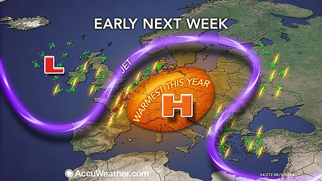
De heetste lucht tot nu toe van dit seizoen trekt volgende week naar het midden van Europa. Hierdoor kunnen er zware onweersbuien ontstaan. De temperaturen zullen vanaf het weekeind al gaan stijgen. Dit komt, doordat een buiencomplex richting het noorden de regio uittrekt. Hierdoor kan zich een rug van hogedruk op gaan bouwen. In Parijs en Berlijn lopen de temperaturen zaterdag makkelijk op tot zo'n 29C. De krachtige rug van hogedruk helpt de warmte lucht richting het midden van Europa te pompen. Ook volgende week heeft Europa met dit weerpatroon te maken. De warmste dagen zijn vermoedelijk maandag en dinsdag.
De stroom van hitte zal gepaard gaan met een toename van de luchtvochtigheid. Hierdoor voelt het nog warmer en klammer aan. De combinatie van hitte en vochtigheid kan zorgen voor zware tot zeer zware onweersbuien. De warmste lucht bevind zich vooral in het oosten. Londen en het zuiden van Engeland krijgen op zaterdag ook te maken met zware onweersbuien. Deze kunnen gepaard gaan met zware windstoten en grote hagelstenen. Er zijn zorgen, dat een koufront gaat botsen met de hitte boven het midden van Europa met alle gevolgen vandien. De gevaren zone ligt maandag over het westen en noorden van Frankrijk en op dinsdag over het oosten van Frankrijk, België, Nederland en Duitsland.
© onweer-online
Bron: Accuweather
| Gewijzigd: 6 juni 2014, 22:57 uur, door Debbieke
Every cloud has a silver lining

Als het koufront botst met de hete lucht met alle gevolgen van dien. In de zin van? Noodweer?
Onweersdagen 2013: 9
Onweersdagen 2014: 15
Onweersdagen 2015: 4 (Geen één keer goed onweer helaas)
Onweersdagen 2016: 9 (6x matig, 3x zwaar)
Onweersdagen 2017: 4 (3x licht, 1x matig)
Onweersdagen 2018: 2
Rolwolken/shelfclouds: 3
23-07-2013: dag om nooit meer te vergeten
23-06-2016: Blikseminslag om nooit te vergeten
Onweersdagen 2014: 15
Onweersdagen 2015: 4 (Geen één keer goed onweer helaas)
Onweersdagen 2016: 9 (6x matig, 3x zwaar)
Onweersdagen 2017: 4 (3x licht, 1x matig)
Onweersdagen 2018: 2
Rolwolken/shelfclouds: 3
23-07-2013: dag om nooit meer te vergeten
23-06-2016: Blikseminslag om nooit te vergeten
Citaat van Hunder, vrijdag 6 juni 2014, 18:29 uur Als het koufront botst met de hete lucht met alle gevolgen van dien. In de zin van? Noodweer?
Ja noodweer in de zin van zware buien en onweer.
Als je precies wilt weten hoe dit mechanisme werkt, raad ik je deze link aan:
http://nl.wikipedia.org/wiki/Koufront | Gewijzigd: 7 juni 2014, 09:26 uur, door Marga
Ja noodweer in de zin van zware buien en onweer.
Als je precies wilt weten hoe dit mechanisme werkt, raad ik je deze link aan:
http://nl.wikipedia.org/wiki/Koufront | Gewijzigd: 7 juni 2014, 09:26 uur, door Marga
Every cloud has a silver lining

#Reigate A beginners guide to the Spanish Plume!
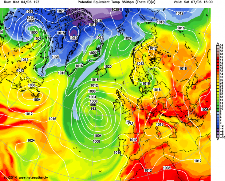
The “Spanish Plume” forecast to arrive from Friday and into Saturday is a special weather set-up for producing thunderstorms in the UK, as seen below.
It is a rather complex weather pattern which needs some special ingredients to prime the atmosphere but also some fine tuning of local conditions to cook-up any big thunderstorms. Spanish Plume thunderstorms are based on convection (thermals of air rising due to surface heating) and storm formation is notoriously difficult to forecast accurately, often being altered by local factors below the resolution of most forecast models. Some places may see a tumultuous thunderstorm of epic proportions while other places not far away will see nothing at all. So an understanding of the plume will help figure out how much at risk you are from any convective action!
If you are in a rush then read the BBC weather summary here (bit shorter!)
Plume weather
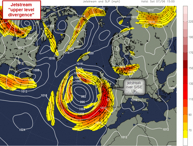
Jetstreak pushing warm southerly air
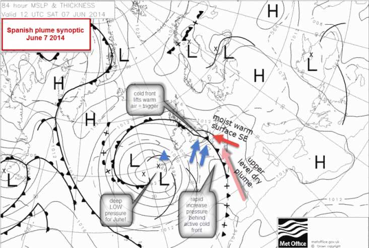
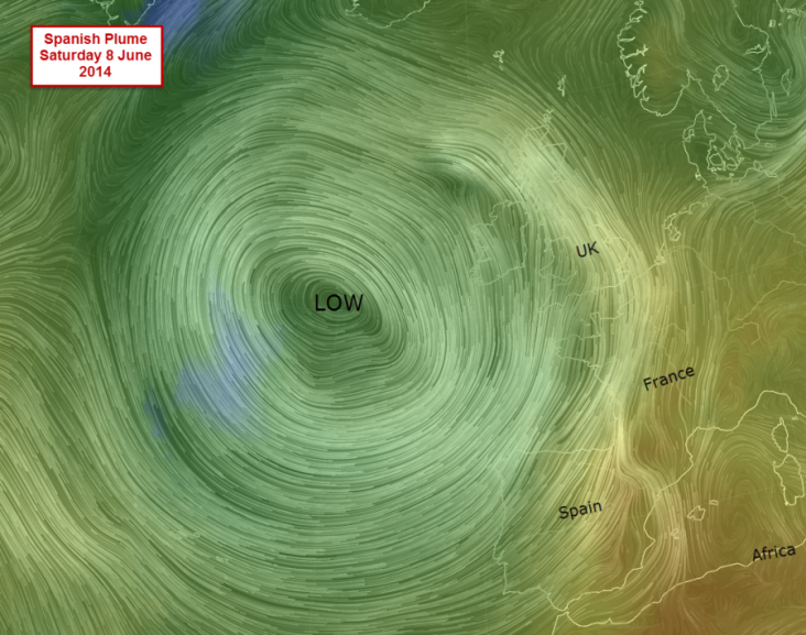
The large scale “synoptic” ingredient that is priming the atmosphere for the possibility of storms is a moderately deep (for June) low pressure that has arrived from a cool NW direction, and will sit in the Atlantic to the SW of the UK and west of Spain. This LOW pressure system has cool moist unstable Atlantic polar maritime air wrapped round numerous fronts. The low pressure system provides the main synoptic ingredient to kick off a Spanish Plume. It spins winds anti-clockwise around the central low and this means that, if the LOW is deep enough (which this one is for June at an unseasonable 988mb) and located in just the right place, powerful upper winds driven by a lively jetstream will reach the UK from a warm southerly direction ahead of any fronts as the LOW inches towards the UK. HIGH pressure over the Mediterranean will also help to push winds out of North Africa, over Spain, into France and finally reach Britain across the English Channel. This southerly wind is what is known as a “plume”. It is characteristically a dry airmass, often loaded with Saharan dust, that arrives in the UK at relatively high levels, above around 1000m, as it rides over local boundary layer weather nearer the surface.
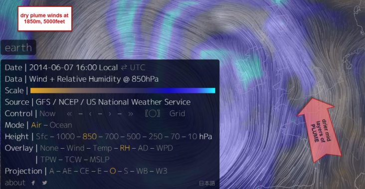
Winds at 5000ft: dry
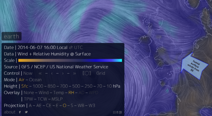
Winds at the surface: moist
Big low showing the plume
Warm airmass for the UK
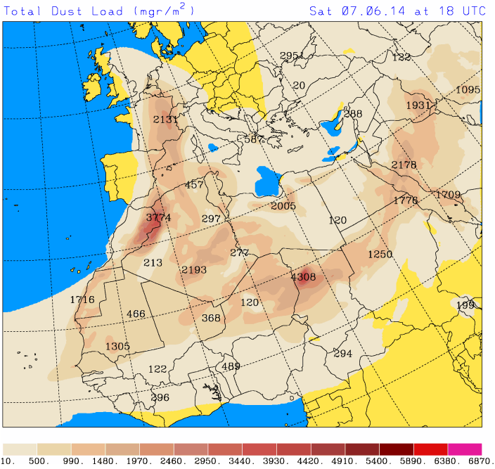
dust also lofted our way…
By itself, a warm dry wind wafting up from Spain will not necessarily create any big bangs. Other, smaller scale ingredients (herbs and spices if you like) are required to finally cook-up a good thunderstorm, with perhaps large hail, cg (cloud to ground) lightning and thunder and even funnel clouds or a tornado. Thunderstorm triggers are needed to push the air UP. Thunderstorms require some critical ingredients: heat, moisture and lift. Additionally, convergence of winds, hills and wind shear and nearby FRONTS can also contribute to the thunderstorm cook-up.
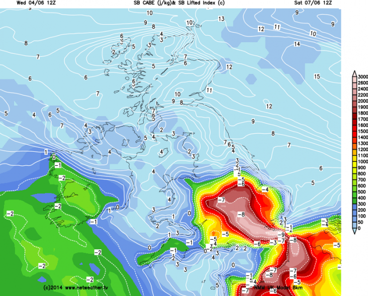
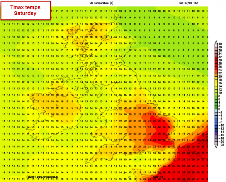
Heat: the SE of England is due to get warm or even hot on Saturday with Tmax temps well over 25c in sunny spots. This will warm the air at the surface and, like a hot air balloon, these air “parcels” will want to rise (called lift). Warm air is also being moved into the country from the south by a process called advection. Charts showing the heat energy providing the potential for air to rise are called CAPE: convective available potential energy. In the UK we are pleased with CAPE values of 200-500j/Kg for some thunderstorms. On Saturday we might expect values of up to 3000j/Kg. The other measure used to assess thunderstorm potential is the LIFTED INDEX (LI) this measures the difference in temperature between a parcel of air lifted to 5000m and the temperature of the air around it. Negative figures show the air is buoyant and ready to rise. Values of -8 or -9 are unusually low and show a very unstable airmass with the potential for plenty of lift!
High CAPE j/Kg and low LI
= High storm risk
A warm day expected
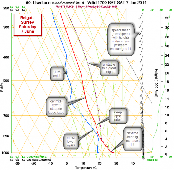
Moisture: local SE winds are set to be quite humid with a relatively high water content: high dew points illustrate this with some reaching 20c on Saturday… a muggy humid day. This moisture will be required, of course, to form clouds. To form really big clouds you need a lot of water in the atmosphere. Once water vapour starts to condense it releases latent heat and this heat gives additional lift to convection and feed thunderstorm formation. Interestingly and perhaps counter to what might be expected, a dry plume of air mid-way up through the atmosphere is also an important ingredient to the production of big thunderstorms. Drier air at mid-levels aloft gives the atmosphere added instability for the production of thunderstorms. The reason for this is that dry air cools more rapidly with height than moist air (because rising moist air releases latent heat when clouds inevitably form and this additional heat reduces the rate of cooling of saturated air with height). The rate of cooling with height is called the “lapse rate” and the lapse rates or temperature gradient on Saturday is steep. So moisture is a critical ingredient to storm formation because it controls instability and cloud formation.
Morning capped
Afternoon instability
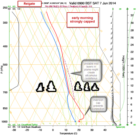
The skew-t charts show temperature change with altitude. They are called Skew-t because the temperature lines are skewed off the vertical slightly. Whilst they are initially odd to look at, focus on the red and blue and dashed lines: if the red and blue lines are close together it means the air is saturated (cloudy). If they are far apart then the air is dry. If the red line skews to the right then this is known as an inversion where temperatures can increase or stay the same with height. Such an inversion will prevent thermals rising and the formation of clouds from surface convection, a critical ingredient for big thunderstorms.
More analysis of Skew-t
The other ingredient the skew-t chart shows above is plenty of wind shear with height, in this case speed shear. Wind shear is the change of wind speed and/or direction with height. Increasing wind speed with height has the effect of dragging air off the ground like a hoover. On Saturday there is a jetstream moving overhead during the day and this will cause divergence aloft and encourage more air to lift off the surface. Strong directional wind shear, when winds turn at angles through the atmosphere and when different winds directions meet around fronts, is also a trigger for tornadoes. The UK quite regularly has tornadic conditions in lively convective thunderstorm weather but the ingredients for tornadoes are a even more fickle! Our tornadoes are considerably less powerful than those in the USA but can be of great interest and still cause damage by uprooting trees, damaging rooves and chimneys and even tipping cars.
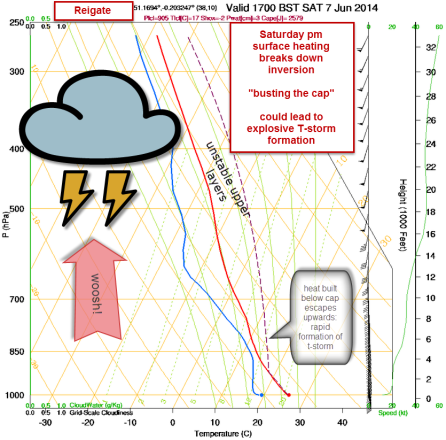
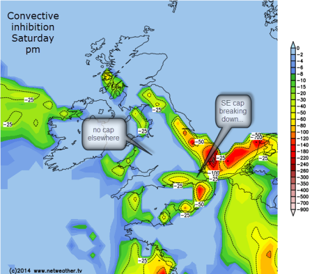
Lift: like a hot air balloon, a warm bubble of air will only rise if it is warmer than the air around it. On Saturday morning a CAP will exist in the atmosphere that will prevent air lifting far off the surface, thus preventing cloud formation. This cap is known as a temperature inversion and the cap on Saturday is pretty solid, so little convection is expected early on. However, during the day the sun will heat the surface and start to break down the cap. A strong cap will build energy and heat below and, if the surface heats up to a threshold then the cap can be broken, usually in the afternoon and a sudden explosive thunderstorm could be produced. In the mid-west of the USA tornado chasers call this process “busting the cap” and it produces the possibility of extreme weather. On charts the cap is shown as convective inhibition that acts against convection. Another mechanism that is capable of lifting air rapidly is the proximity of fronts which can mechanically lift the air as airmasses converge. On Saturday a slow moving cold front is forecast to be located along a north/south axis through the Midlands and S England, moving gradually east… this could be the focus of most activity if the cap remains solid further east.
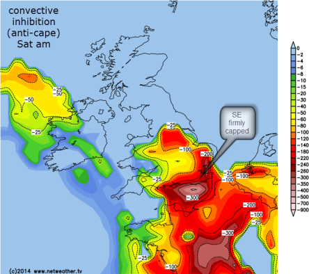
Strong cap am
Breaking down pm
Convergence of winds: winds converging at the surface are another local or regional factor that enhances convection. Converging winds at the surface tend to slow down and pile up, like lorries slowing down uphill and causing congestion. When surface winds pile into each other (converge) they can only go one way… UP! Convergence often occurs at the coast where winds coming from the sea slow down due to friction over the land. This is one reason why the south coast often produces thunderstorms or enhances them as they cross the Channel (so long as the Channel sea surface temperature is warm enough – another story!). The other map below shows areas where there is a sufficient combination of wind shear, heating and energy to possibly start to rotate a thunderstorm: rotating thunderstorms are called supercells and are capable of producing tornadoes. These are the “big daddy” of thunderstorm cells and would be an awesome site for anyone able to catch a photo before or after the inevitable heavy rain, hail, lightning, darkening skies and thunder!
Converging moist winds over the UK – saturday
Storm relative helicity? OK, a map showing possible supercell formation
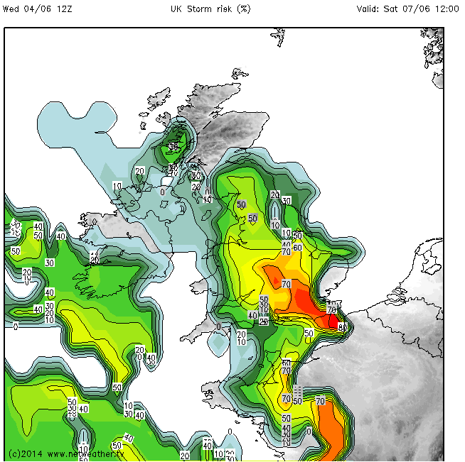
Even with so many ingredients primed for thundery weather here in Reigate on Saturday it still remains a risk potential rather than a certainty. Local factors might inhibit convection, too much cloud in the morning could reduce surface heating and the cap may not be broken, so no thunderstorms! It’s a matter of waiting to see the conditions nearer the time to make a final forecast and often it remains uncertain until the very day. Nevertheless, there is a possibility of explosive convective thunderstorm action on Saturday, mostly in the Midlands and the East, if the CAP is BUST! If this occurs then instability of the atmosphere will rapidly build extremely tall cumulonimbus clouds up to 10,000 metres tall. The UKMO issued an uncharacteristically early warning of heavy rain for Saturday on the basis of this Spanish Plume event. Others will doubtless follow, but it is safe to ignore the daft scaremongering of the Daily Express but keep a watchful eye on any dark clouds!
Although an accurate forecast is beyond the scope of this post and best left to the professionals, one broad indicator of possible storm pattern over the course of the day is set by convergence of winds and likely position of the front. The first plume of instability arrives in N France on Friday and some might arrive S England Friday pm with low risk thunderstorm activity imported across the Channel from France. The charts for Saturday below show how the main location of biggest storm activity could move broadly from west to NE during Saturday and clear off into the N Sea overnight.
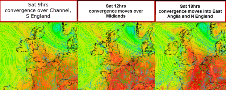
The animation here also shows the total rainfall expected to accumulate during the 48 hour plume event.
Bron: Rgsweather | Gewijzigd: 7 juni 2014, 10:14 uur, door Ries
The “Spanish Plume” forecast to arrive from Friday and into Saturday is a special weather set-up for producing thunderstorms in the UK, as seen below.
It is a rather complex weather pattern which needs some special ingredients to prime the atmosphere but also some fine tuning of local conditions to cook-up any big thunderstorms. Spanish Plume thunderstorms are based on convection (thermals of air rising due to surface heating) and storm formation is notoriously difficult to forecast accurately, often being altered by local factors below the resolution of most forecast models. Some places may see a tumultuous thunderstorm of epic proportions while other places not far away will see nothing at all. So an understanding of the plume will help figure out how much at risk you are from any convective action!
If you are in a rush then read the BBC weather summary here (bit shorter!)
Plume weather
Jetstreak pushing warm southerly air
The large scale “synoptic” ingredient that is priming the atmosphere for the possibility of storms is a moderately deep (for June) low pressure that has arrived from a cool NW direction, and will sit in the Atlantic to the SW of the UK and west of Spain. This LOW pressure system has cool moist unstable Atlantic polar maritime air wrapped round numerous fronts. The low pressure system provides the main synoptic ingredient to kick off a Spanish Plume. It spins winds anti-clockwise around the central low and this means that, if the LOW is deep enough (which this one is for June at an unseasonable 988mb) and located in just the right place, powerful upper winds driven by a lively jetstream will reach the UK from a warm southerly direction ahead of any fronts as the LOW inches towards the UK. HIGH pressure over the Mediterranean will also help to push winds out of North Africa, over Spain, into France and finally reach Britain across the English Channel. This southerly wind is what is known as a “plume”. It is characteristically a dry airmass, often loaded with Saharan dust, that arrives in the UK at relatively high levels, above around 1000m, as it rides over local boundary layer weather nearer the surface.
Winds at 5000ft: dry
Winds at the surface: moist
Big low showing the plume
Warm airmass for the UK
dust also lofted our way…
By itself, a warm dry wind wafting up from Spain will not necessarily create any big bangs. Other, smaller scale ingredients (herbs and spices if you like) are required to finally cook-up a good thunderstorm, with perhaps large hail, cg (cloud to ground) lightning and thunder and even funnel clouds or a tornado. Thunderstorm triggers are needed to push the air UP. Thunderstorms require some critical ingredients: heat, moisture and lift. Additionally, convergence of winds, hills and wind shear and nearby FRONTS can also contribute to the thunderstorm cook-up.
Heat: the SE of England is due to get warm or even hot on Saturday with Tmax temps well over 25c in sunny spots. This will warm the air at the surface and, like a hot air balloon, these air “parcels” will want to rise (called lift). Warm air is also being moved into the country from the south by a process called advection. Charts showing the heat energy providing the potential for air to rise are called CAPE: convective available potential energy. In the UK we are pleased with CAPE values of 200-500j/Kg for some thunderstorms. On Saturday we might expect values of up to 3000j/Kg. The other measure used to assess thunderstorm potential is the LIFTED INDEX (LI) this measures the difference in temperature between a parcel of air lifted to 5000m and the temperature of the air around it. Negative figures show the air is buoyant and ready to rise. Values of -8 or -9 are unusually low and show a very unstable airmass with the potential for plenty of lift!
High CAPE j/Kg and low LI
= High storm risk
A warm day expected
Moisture: local SE winds are set to be quite humid with a relatively high water content: high dew points illustrate this with some reaching 20c on Saturday… a muggy humid day. This moisture will be required, of course, to form clouds. To form really big clouds you need a lot of water in the atmosphere. Once water vapour starts to condense it releases latent heat and this heat gives additional lift to convection and feed thunderstorm formation. Interestingly and perhaps counter to what might be expected, a dry plume of air mid-way up through the atmosphere is also an important ingredient to the production of big thunderstorms. Drier air at mid-levels aloft gives the atmosphere added instability for the production of thunderstorms. The reason for this is that dry air cools more rapidly with height than moist air (because rising moist air releases latent heat when clouds inevitably form and this additional heat reduces the rate of cooling of saturated air with height). The rate of cooling with height is called the “lapse rate” and the lapse rates or temperature gradient on Saturday is steep. So moisture is a critical ingredient to storm formation because it controls instability and cloud formation.
Morning capped
Afternoon instability
The skew-t charts show temperature change with altitude. They are called Skew-t because the temperature lines are skewed off the vertical slightly. Whilst they are initially odd to look at, focus on the red and blue and dashed lines: if the red and blue lines are close together it means the air is saturated (cloudy). If they are far apart then the air is dry. If the red line skews to the right then this is known as an inversion where temperatures can increase or stay the same with height. Such an inversion will prevent thermals rising and the formation of clouds from surface convection, a critical ingredient for big thunderstorms.
More analysis of Skew-t
The other ingredient the skew-t chart shows above is plenty of wind shear with height, in this case speed shear. Wind shear is the change of wind speed and/or direction with height. Increasing wind speed with height has the effect of dragging air off the ground like a hoover. On Saturday there is a jetstream moving overhead during the day and this will cause divergence aloft and encourage more air to lift off the surface. Strong directional wind shear, when winds turn at angles through the atmosphere and when different winds directions meet around fronts, is also a trigger for tornadoes. The UK quite regularly has tornadic conditions in lively convective thunderstorm weather but the ingredients for tornadoes are a even more fickle! Our tornadoes are considerably less powerful than those in the USA but can be of great interest and still cause damage by uprooting trees, damaging rooves and chimneys and even tipping cars.
Lift: like a hot air balloon, a warm bubble of air will only rise if it is warmer than the air around it. On Saturday morning a CAP will exist in the atmosphere that will prevent air lifting far off the surface, thus preventing cloud formation. This cap is known as a temperature inversion and the cap on Saturday is pretty solid, so little convection is expected early on. However, during the day the sun will heat the surface and start to break down the cap. A strong cap will build energy and heat below and, if the surface heats up to a threshold then the cap can be broken, usually in the afternoon and a sudden explosive thunderstorm could be produced. In the mid-west of the USA tornado chasers call this process “busting the cap” and it produces the possibility of extreme weather. On charts the cap is shown as convective inhibition that acts against convection. Another mechanism that is capable of lifting air rapidly is the proximity of fronts which can mechanically lift the air as airmasses converge. On Saturday a slow moving cold front is forecast to be located along a north/south axis through the Midlands and S England, moving gradually east… this could be the focus of most activity if the cap remains solid further east.
Strong cap am
Breaking down pm
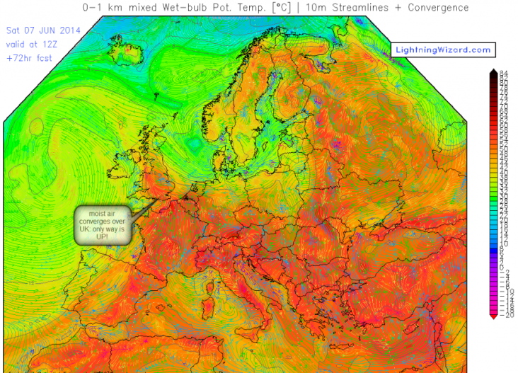
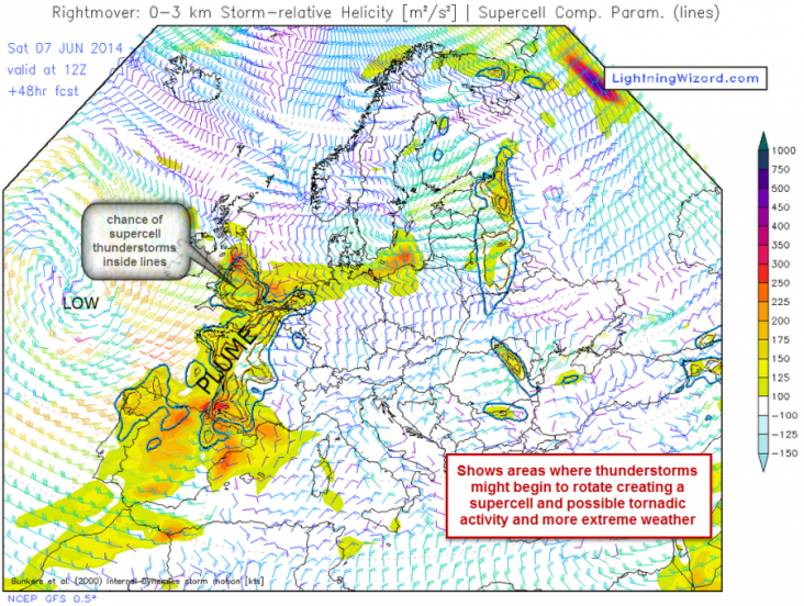
Convergence of winds: winds converging at the surface are another local or regional factor that enhances convection. Converging winds at the surface tend to slow down and pile up, like lorries slowing down uphill and causing congestion. When surface winds pile into each other (converge) they can only go one way… UP! Convergence often occurs at the coast where winds coming from the sea slow down due to friction over the land. This is one reason why the south coast often produces thunderstorms or enhances them as they cross the Channel (so long as the Channel sea surface temperature is warm enough – another story!). The other map below shows areas where there is a sufficient combination of wind shear, heating and energy to possibly start to rotate a thunderstorm: rotating thunderstorms are called supercells and are capable of producing tornadoes. These are the “big daddy” of thunderstorm cells and would be an awesome site for anyone able to catch a photo before or after the inevitable heavy rain, hail, lightning, darkening skies and thunder!
Converging moist winds over the UK – saturday
Storm relative helicity? OK, a map showing possible supercell formation
Even with so many ingredients primed for thundery weather here in Reigate on Saturday it still remains a risk potential rather than a certainty. Local factors might inhibit convection, too much cloud in the morning could reduce surface heating and the cap may not be broken, so no thunderstorms! It’s a matter of waiting to see the conditions nearer the time to make a final forecast and often it remains uncertain until the very day. Nevertheless, there is a possibility of explosive convective thunderstorm action on Saturday, mostly in the Midlands and the East, if the CAP is BUST! If this occurs then instability of the atmosphere will rapidly build extremely tall cumulonimbus clouds up to 10,000 metres tall. The UKMO issued an uncharacteristically early warning of heavy rain for Saturday on the basis of this Spanish Plume event. Others will doubtless follow, but it is safe to ignore the daft scaremongering of the Daily Express but keep a watchful eye on any dark clouds!
Although an accurate forecast is beyond the scope of this post and best left to the professionals, one broad indicator of possible storm pattern over the course of the day is set by convergence of winds and likely position of the front. The first plume of instability arrives in N France on Friday and some might arrive S England Friday pm with low risk thunderstorm activity imported across the Channel from France. The charts for Saturday below show how the main location of biggest storm activity could move broadly from west to NE during Saturday and clear off into the N Sea overnight.
The animation here also shows the total rainfall expected to accumulate during the 48 hour plume event.
Bron: Rgsweather | Gewijzigd: 7 juni 2014, 10:14 uur, door Ries
Freedom is not worth having if it does not include the freedom to make mistakes.
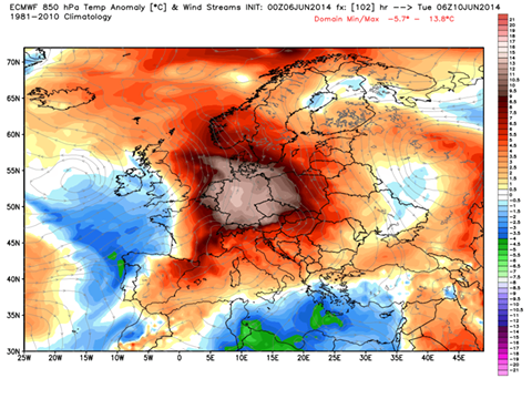
Some mid-range predictions for the upcoming heat wave across central Europe in the week ahead. 850mb temperature anomaly during the peak days (Tuesday-Wednesday) are expected to range between 8-14°C above the normal values, the highest over Germany. Locally, daily max values should exceed 35°C in those days.
Source: WeatherBell
Every cloud has a silver lining
Uitbraak van Severe Weather in Europa
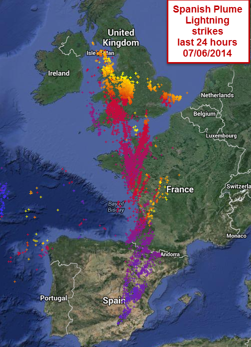
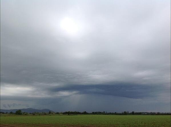
De zinderende hitte, die zich opbouwt boven het midden van Europa zorgt ervoor, dat er een meerdaags severe weather event plaatsvindt. Deze eindigt op woensdag. Een koufront glijdt in de-warmste-lucht-tot-nu-toe-dit-jaar. Hierdoor krijgen de gebieden vanaf Frankrijk tot het westen van Polen en het noorden van Italië te maken met zeer krachtige onweersbuien.
Deze uitbraak van noodweer begint op maandagmiddag in het westen en noorden van Frankrijk, in België en over Nederland. In de avond trekt dit gebied weg richting het noordwesten van Duitsland. De krachtigste onweersbuien, die maandag laat in de middag en in de avond gaan vallen, kunnen destructieve windstoten, grote hagelstenen en verblindende stortbuien veroorzaken.
Volgens meteoroloog Tyler Roys kunnen er ook tornado's voortkomen uit de buien. Deze zullen zich vermoedelijk concentreren in de strook van het noorden van Frankrijk naar het noordwesten van Duitsland.
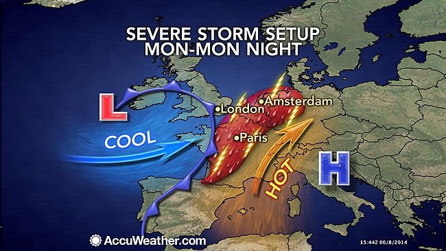
Vervolgens trekken de zware onweersbuien op dinsdag richting Denemarken en het midden van Duitsland maar naar Zwitserland en het naburige deel van Frankrijk. Deze buien met eveneens destructieve windstoten en stortregens zullen vooral in Denemarken en het noorden van Duitsland wijdverspreid voorkomen. In de overige gebieden hebben ze een meer lokaal karakter. Ongeacht de grootte van de complexen: er is maar één zware onweersbui nodig om veel schade te veroorzaken.
Op woensdag ligt het risicogebied voor zware buien vanaf het westen van Polen tot net noorden van Itali:e en het zuidoosten van Frankrijk. Al met al zullen in sommige delen van het midden van Europa weer tot recordhoogtes stijgen. Dinsdag zal bijvoorbeeld in Berlijn het kwik oplopen tot een zinderende 34C.
© onweer-online
Bron: Accuweather
De zinderende hitte, die zich opbouwt boven het midden van Europa zorgt ervoor, dat er een meerdaags severe weather event plaatsvindt. Deze eindigt op woensdag. Een koufront glijdt in de-warmste-lucht-tot-nu-toe-dit-jaar. Hierdoor krijgen de gebieden vanaf Frankrijk tot het westen van Polen en het noorden van Italië te maken met zeer krachtige onweersbuien.
Deze uitbraak van noodweer begint op maandagmiddag in het westen en noorden van Frankrijk, in België en over Nederland. In de avond trekt dit gebied weg richting het noordwesten van Duitsland. De krachtigste onweersbuien, die maandag laat in de middag en in de avond gaan vallen, kunnen destructieve windstoten, grote hagelstenen en verblindende stortbuien veroorzaken.
Volgens meteoroloog Tyler Roys kunnen er ook tornado's voortkomen uit de buien. Deze zullen zich vermoedelijk concentreren in de strook van het noorden van Frankrijk naar het noordwesten van Duitsland.
Vervolgens trekken de zware onweersbuien op dinsdag richting Denemarken en het midden van Duitsland maar naar Zwitserland en het naburige deel van Frankrijk. Deze buien met eveneens destructieve windstoten en stortregens zullen vooral in Denemarken en het noorden van Duitsland wijdverspreid voorkomen. In de overige gebieden hebben ze een meer lokaal karakter. Ongeacht de grootte van de complexen: er is maar één zware onweersbui nodig om veel schade te veroorzaken.
Op woensdag ligt het risicogebied voor zware buien vanaf het westen van Polen tot net noorden van Itali:e en het zuidoosten van Frankrijk. Al met al zullen in sommige delen van het midden van Europa weer tot recordhoogtes stijgen. Dinsdag zal bijvoorbeeld in Berlijn het kwik oplopen tot een zinderende 34C.
© onweer-online
Bron: Accuweather
Every cloud has a silver lining
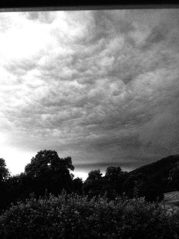
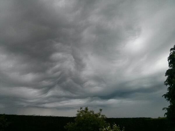
Prachtige foto's van de onweersbuien, die over Worcestershire en Herefordshire trokken
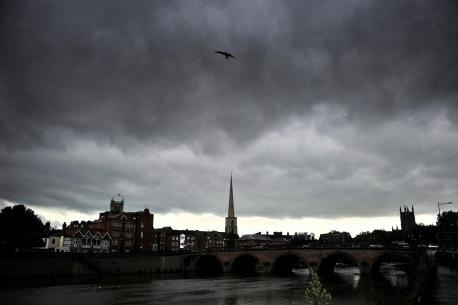
Stormclouds gather over Worcester. Picture by Jonathan Barry
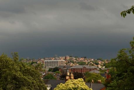
Dark skies over Worcester this morning. Picture by Paul Jackson
![[t]](/images/smilies/t.gif "[t]") Adrian Bailes @ThisIsADB
Adrian Bailes @ThisIsADB
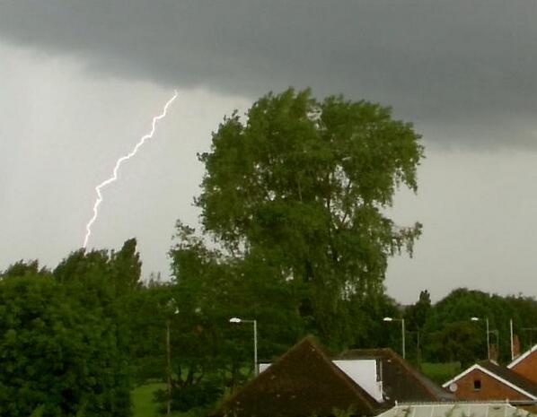
That sky produced this lightning. Taken looking over Diglis.
Alexander Mills @AGJMills
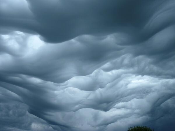
It's all thunder and lightning and pretty clouds
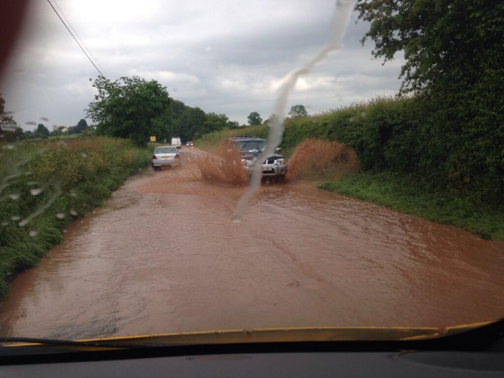
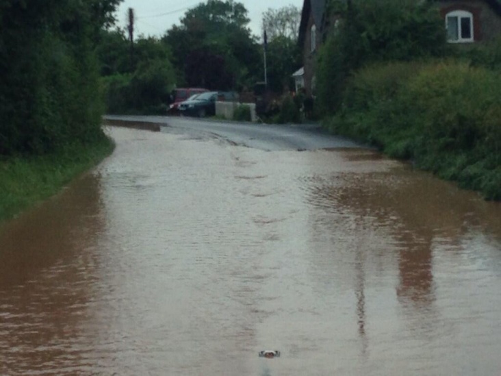
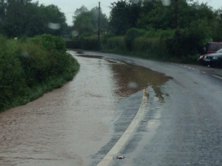
Dave Harford @dharford79 A465 at Withington badly affected!
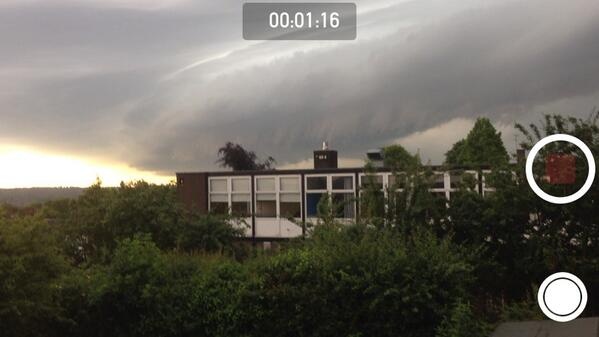
Chris Mould @mouldypants
the look of a supercell over #stourbridge #rotationofclouds
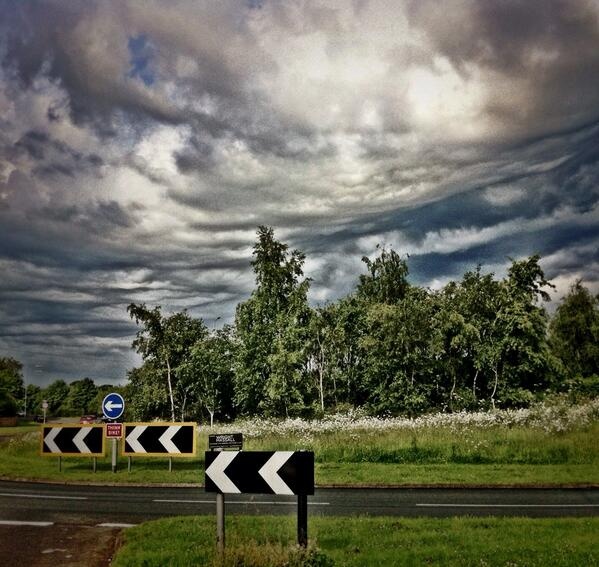
Harvey Pope @magicmrp
Amazing formations over Leamington Spa!
Rob @eaglesboy2
Stormy over the Malvern hills!
Rich Hadley @RichPossibility
Stonking storm over Herefordshire. This sky was the harbinger..
Dave Throup @DaveThroupEA
On the edge of the #hereford thunderstorm. Remarkable skies!
Bron: Worcseternews
Stormclouds gather over Worcester. Picture by Jonathan Barry
Dark skies over Worcester this morning. Picture by Paul Jackson
That sky produced this lightning. Taken looking over Diglis.
It's all thunder and lightning and pretty clouds
the look of a supercell over #stourbridge #rotationofclouds
Amazing formations over Leamington Spa!
Stormy over the Malvern hills!
Stonking storm over Herefordshire. This sky was the harbinger..
On the edge of the #hereford thunderstorm. Remarkable skies!
Bron: Worcseternews
Every cloud has a silver lining
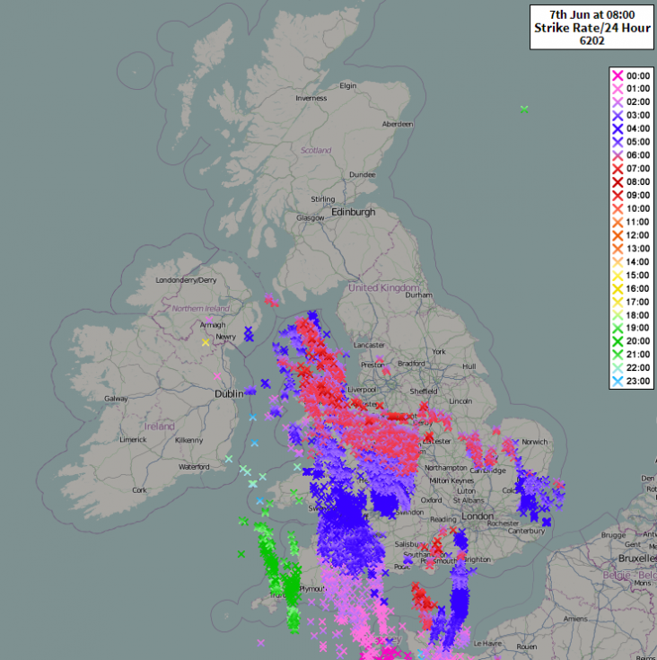
De reports die zijn binnen gekomen bij het ESWD met het Pinksterweekend. Op 7, 8 en 9 juni kwamen er maarliefst 278 reports binnen, waarvan meer dan 200 in de Benelux en een deel van zuid-west Duitsland richting noord-oost Duitsland.
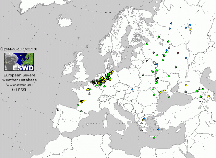
Kaart: ESWD | Gewijzigd: 13 juni 2014, 12:30 uur, door Ries
Kaart: ESWD | Gewijzigd: 13 juni 2014, 12:30 uur, door Ries
Freedom is not worth having if it does not include the freedom to make mistakes.