Tornadoes and Violent Thunderstorms Return Monday
Thunderstorm Forecast: Next 12 Hours
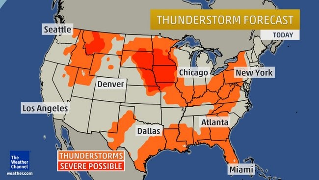
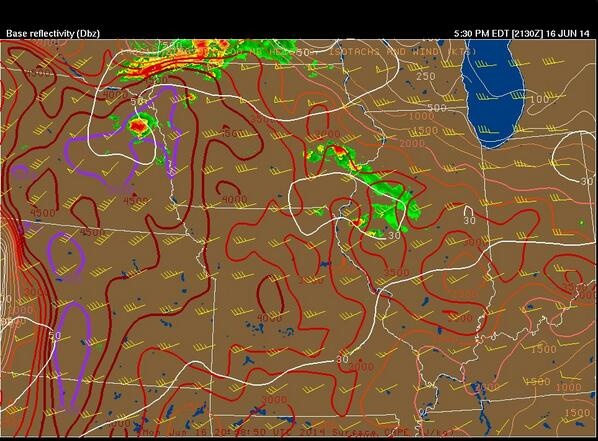
Red shading indicates areas with the best chance of severe thunderstorms; orange shades can expect thunderstorms, but have little or no threat of severe weather. By definition, severe thunderstorms have one of the following: wind gusts of at least 58 mph, hail at least 1 inch in diameter, or a tornado. Severe thunderstorms will flare up in parts of the Upper Midwest, Missouri Valley and Plains Monday into Monday night. Large hail and damaging straight-line winds are possible from South Dakota, Minnesota and Wisconsin to the Texas Panhandle. The highest threat for tornadoes, some possibly strong, appears to be near the warm front and weak surface low from eastern South Dakota and northeast Nebraska into southern Minnesota and northern Iowa. Overnight, a complex of thunderstorms with strong winds and heavy rain will track east into the western Great Lakes and Upper Mississippi Valley.
Flash Flood Risk
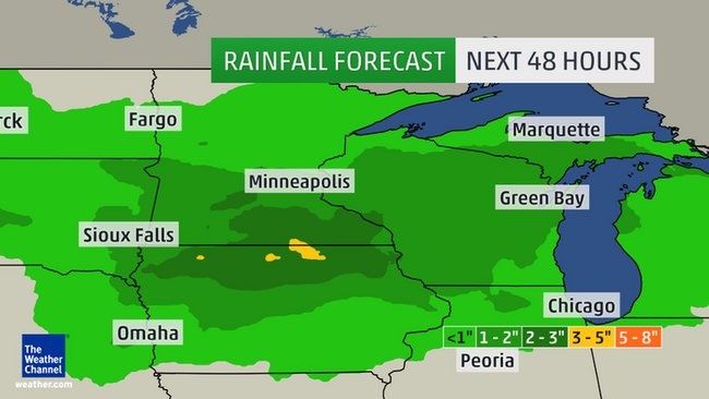
Heavy rainfall this past weekend, in addition to soaking rain earlier this month, has left the ground saturated in parts of southern Minnesota, southeast South Dakota, northeast Nebraska and northwest Iowa. The Rock River at Luverne, Minnesota, crested at an all-time record on Father's Day. Sioux Falls, South Dakota picked up 4.71 inches of rain last weekend, pushing them to an all-time monthly rain record of 9.97 inches, through June 15. Any additional heavy rainfall over this region will quickly runoff, leading to additional flash flooding of fields, roads, and rises on area rivers and streams. Unfortunately, a complex of thunderstorms may bring locally heavy rain to parts of this region each evening through Thursday evening. Lightning is of course always dangerous. Keep that in mind if you have outdoor plans in the orange areas on our thunderstorm maps.
Bron: The Weather Channel
Thunderstorm Forecast: Next 12 Hours
Red shading indicates areas with the best chance of severe thunderstorms; orange shades can expect thunderstorms, but have little or no threat of severe weather. By definition, severe thunderstorms have one of the following: wind gusts of at least 58 mph, hail at least 1 inch in diameter, or a tornado. Severe thunderstorms will flare up in parts of the Upper Midwest, Missouri Valley and Plains Monday into Monday night. Large hail and damaging straight-line winds are possible from South Dakota, Minnesota and Wisconsin to the Texas Panhandle. The highest threat for tornadoes, some possibly strong, appears to be near the warm front and weak surface low from eastern South Dakota and northeast Nebraska into southern Minnesota and northern Iowa. Overnight, a complex of thunderstorms with strong winds and heavy rain will track east into the western Great Lakes and Upper Mississippi Valley.
Flash Flood Risk
Heavy rainfall this past weekend, in addition to soaking rain earlier this month, has left the ground saturated in parts of southern Minnesota, southeast South Dakota, northeast Nebraska and northwest Iowa. The Rock River at Luverne, Minnesota, crested at an all-time record on Father's Day. Sioux Falls, South Dakota picked up 4.71 inches of rain last weekend, pushing them to an all-time monthly rain record of 9.97 inches, through June 15. Any additional heavy rainfall over this region will quickly runoff, leading to additional flash flooding of fields, roads, and rises on area rivers and streams. Unfortunately, a complex of thunderstorms may bring locally heavy rain to parts of this region each evening through Thursday evening. Lightning is of course always dangerous. Keep that in mind if you have outdoor plans in the orange areas on our thunderstorm maps.
Bron: The Weather Channel
Every cloud has a silver lining
Powerful Storms Return Monday to Minneapolis, Omaha
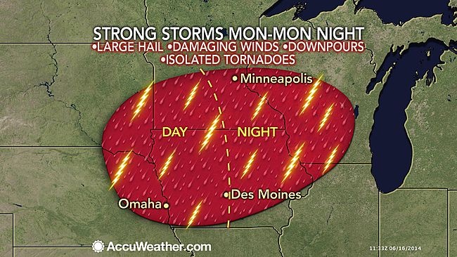
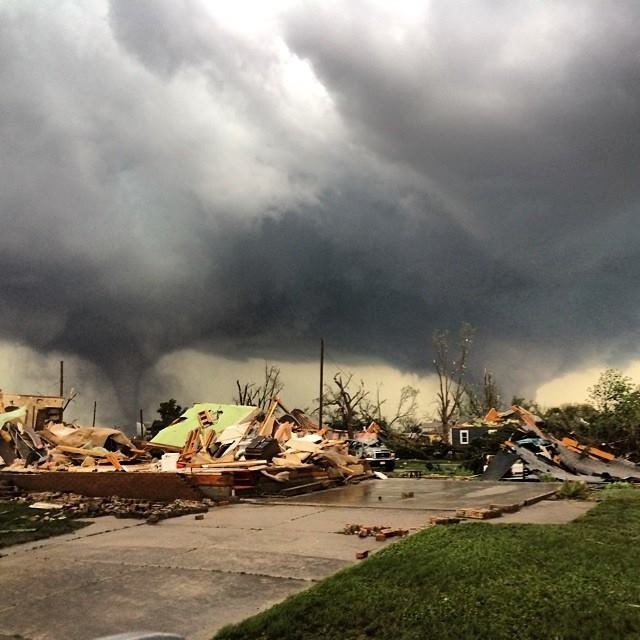
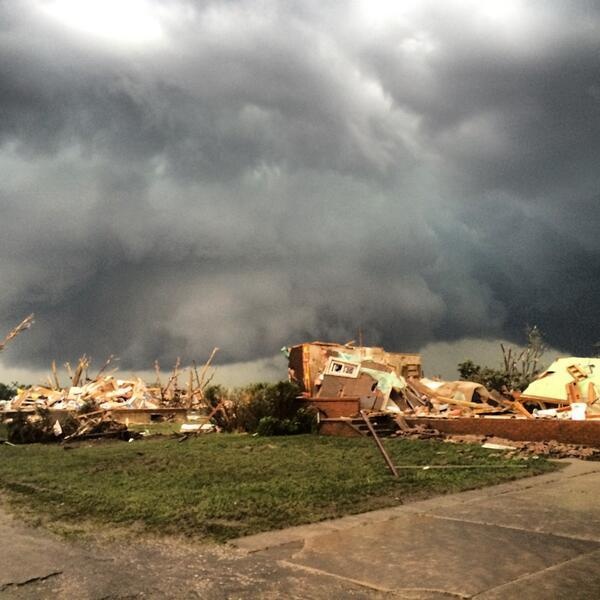
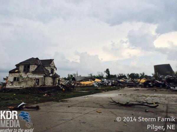
Two days after severe thunderstorms rocked the Plains and Midwest, another round of severe weather is expected to kick off what looks like a stormy week in the Heartland. Lower humidity allowed for comfortable temperatures on Sunday across the region, but moisture will return on Monday and provide fuel for intense thunderstorms from afternoon to nighttime. Some storms can contain damaging winds and large hail across the threat area. Isolated tornadoes can occur with the most intense thunderstorms.
The ground is already saturated in some areas from recent heavy rainfall and additional downpours can cause more flooding. Several rivers are already above flood stage and are still rising as a result of 4 to 7 inches of rain that fell since late last week. Any additional rain will only exacerbate the problem. The Omaha, Nebraska, area has experienced several rounds of severe thunderstorms this month, most recently this past Saturday night with wind gusts over 50 mph from thunderstorms that rolled through.
High winds from thunderstorms knocked down trees and caused power outages in the Minneapolis area this past Saturday. More damage to trees and power outages can occur as a result of these thunderstorms. Some roads may become impassable as a result of flooding, which will cause travel delays. Des Moines, Iowa, could be impacted later in the day on Monday and thunderstorms could reach Madison, Wisconsin, on Monday night.
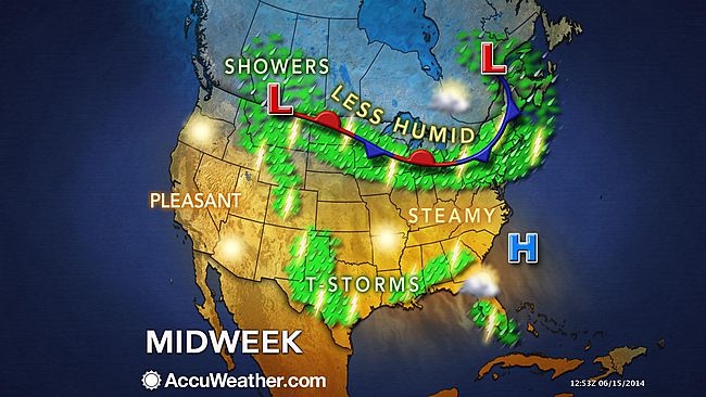
More rough weather is expected into the middle of this week. Waves of thunderstorms will traverse areas from the Plains to the Northeast on Tuesday and Wednesday along a frontal boundary. Thunderstorms, some strong to severe, are a threat both days. Flooding could become a concern if multiple thunderstorms with heavy rainfall track over the same area.
Bron: Accuweather
Two days after severe thunderstorms rocked the Plains and Midwest, another round of severe weather is expected to kick off what looks like a stormy week in the Heartland. Lower humidity allowed for comfortable temperatures on Sunday across the region, but moisture will return on Monday and provide fuel for intense thunderstorms from afternoon to nighttime. Some storms can contain damaging winds and large hail across the threat area. Isolated tornadoes can occur with the most intense thunderstorms.
The ground is already saturated in some areas from recent heavy rainfall and additional downpours can cause more flooding. Several rivers are already above flood stage and are still rising as a result of 4 to 7 inches of rain that fell since late last week. Any additional rain will only exacerbate the problem. The Omaha, Nebraska, area has experienced several rounds of severe thunderstorms this month, most recently this past Saturday night with wind gusts over 50 mph from thunderstorms that rolled through.
High winds from thunderstorms knocked down trees and caused power outages in the Minneapolis area this past Saturday. More damage to trees and power outages can occur as a result of these thunderstorms. Some roads may become impassable as a result of flooding, which will cause travel delays. Des Moines, Iowa, could be impacted later in the day on Monday and thunderstorms could reach Madison, Wisconsin, on Monday night.
More rough weather is expected into the middle of this week. Waves of thunderstorms will traverse areas from the Plains to the Northeast on Tuesday and Wednesday along a frontal boundary. Thunderstorms, some strong to severe, are a threat both days. Flooding could become a concern if multiple thunderstorms with heavy rainfall track over the same area.
Bron: Accuweather
Every cloud has a silver lining

Scott Overpeck @scottao11
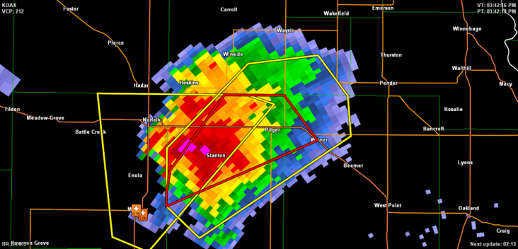
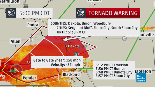
I sure hope that CC minimum is not all #tornado debris. Crazy looking mesocyclone on velocity.
Wright-Weather.com @Wright_Weather
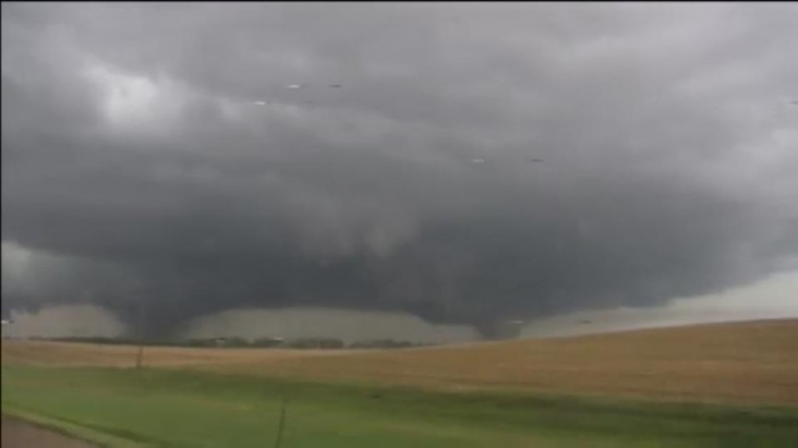
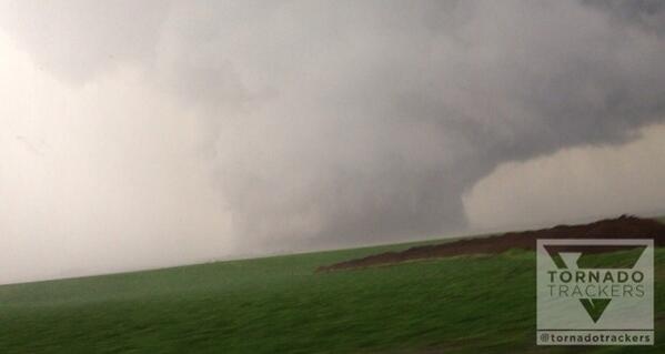
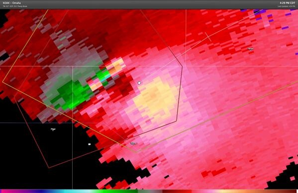
Huge, tornadic supercell in Nebraska is feeding on 5000+ CAPE and 50+ knot mid-level winds. | Gewijzigd: 16 juni 2014, 23:47 uur, door Marga
Every cloud has a silver lining
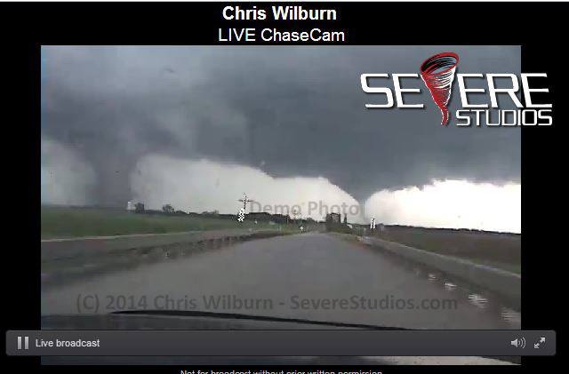
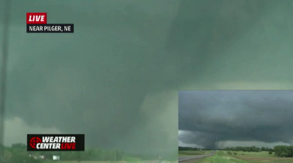
tornadotrackers Massive wedge #tornado now!!! Near Wisner, Nebraska
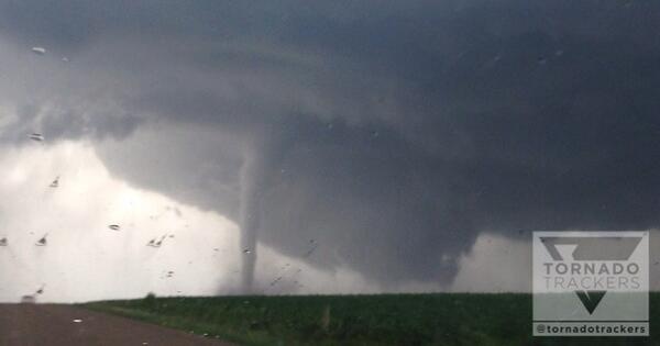
Tornado Trackers @tornadotrackers
Satellite tornado circling around the main tornado! Very dangerous, violent tornado continues near Pender, NE!! | Gewijzigd: 16 juni 2014, 23:53 uur, door Marga
Every cloud has a silver lining

PDS
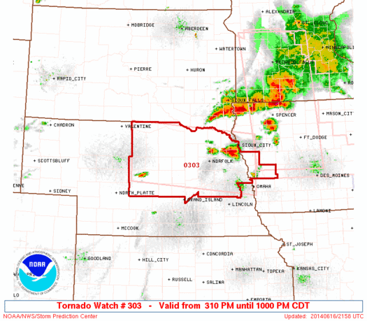
TORNADO WATCH NUMBER 303
NWS STORM PREDICTION CENTER NORMAN OK
310 PM CDT MON JUN 16 2014
THE NWS STORM PREDICTION CENTER HAS ISSUED A
* TORNADO WATCH FOR PORTIONS OF
WEST-CENTRAL IOWA
NORTH-CENTRAL AND NORTHEAST NEBRASKA
* EFFECTIVE THIS MONDAY AFTERNOON AND EVENING FROM 310 PM UNTIL
1000 PM CDT.
...THIS IS A PARTICULARLY DANGEROUS SITUATION...
* PRIMARY THREATS INCLUDE...
SEVERAL TORNADOES AND A FEW INTENSE TORNADOES LIKELY
SCATTERED LARGE HAIL LIKELY WITH ISOLATED VERY LARGE HAIL EVENTS
TO 3 INCHES IN DIAMETER POSSIBLE
SCATTERED DAMAGING WIND GUSTS TO 70 MPH POSSIBLE
THE TORNADO WATCH AREA IS APPROXIMATELY ALONG AND 55 STATUTE
MILES NORTH AND SOUTH OF A LINE FROM 25 MILES SOUTH SOUTHWEST OF
AINSWORTH NEBRASKA TO 20 MILES EAST NORTHEAST OF TEKAMAH
NEBRASKA. FOR A COMPLETE DEPICTION OF THE WATCH SEE THE
ASSOCIATED WATCH OUTLINE UPDATE (WOUS64 KWNS WOU3).
PRECAUTIONARY/PREPAREDNESS ACTIONS...
REMEMBER...A TORNADO WATCH MEANS CONDITIONS ARE FAVORABLE FOR
TORNADOES AND SEVERE THUNDERSTORMS IN AND CLOSE TO THE WATCH
AREA. PERSONS IN THESE AREAS SHOULD BE ON THE LOOKOUT FOR
THREATENING WEATHER CONDITIONS AND LISTEN FOR LATER STATEMENTS
AND POSSIBLE WARNINGS.
&&
OTHER WATCH INFORMATION...CONTINUE...WW 302...
DISCUSSION...THE 19Z OMA SOUNDING SAMPLED A VOLATILE ENVIRONMENT
WITH 4000 J/KG MLCAPE...60 KT OF EFFECTIVE BULK SHEAR...AND 500
EFFECTIVE SRH. ISOLATED TO WIDELY SCATTERED SUPERCELLS ARE EXPECTED
TO DEVELOP ALONG HEATED OUTFLOW BOUNDARIES WITH A RISK FOR VERY
LARGE HAIL AND DAMAGING TORNADOES...A FEW OF WHICH COULD BE
SIGNIFICANT.
AVIATION...TORNADOES AND A FEW SEVERE THUNDERSTORMS WITH HAIL
SURFACE AND ALOFT TO 3 INCHES. EXTREME TURBULENCE AND SURFACE
WIND GUSTS TO 60 KNOTS. A FEW CUMULONIMBI WITH MAXIMUM TOPS TO
600. MEAN STORM MOTION VECTOR 23025.
Every cloud has a silver lining
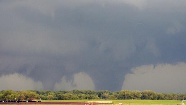
TornadoTitans.com @TornadoTitans
Can clearly see two tornadoes on radar moving around each other. Insane.
Theo Gkousarov @Satdecrypter
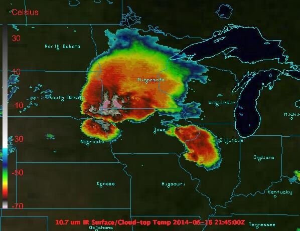
#Tornado reported in #pilger Nebraska. satellite image shows super-cell cloud top temps. Very strong updrafts. | Gewijzigd: 17 juni 2014, 00:06 uur, door Marga
Every cloud has a silver lining