
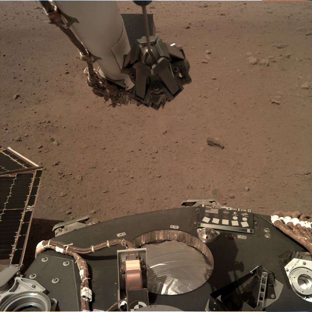
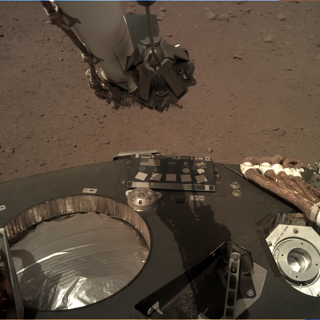
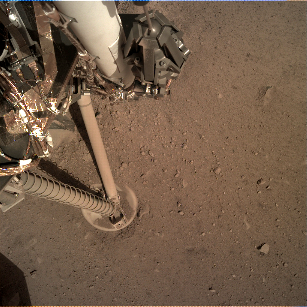
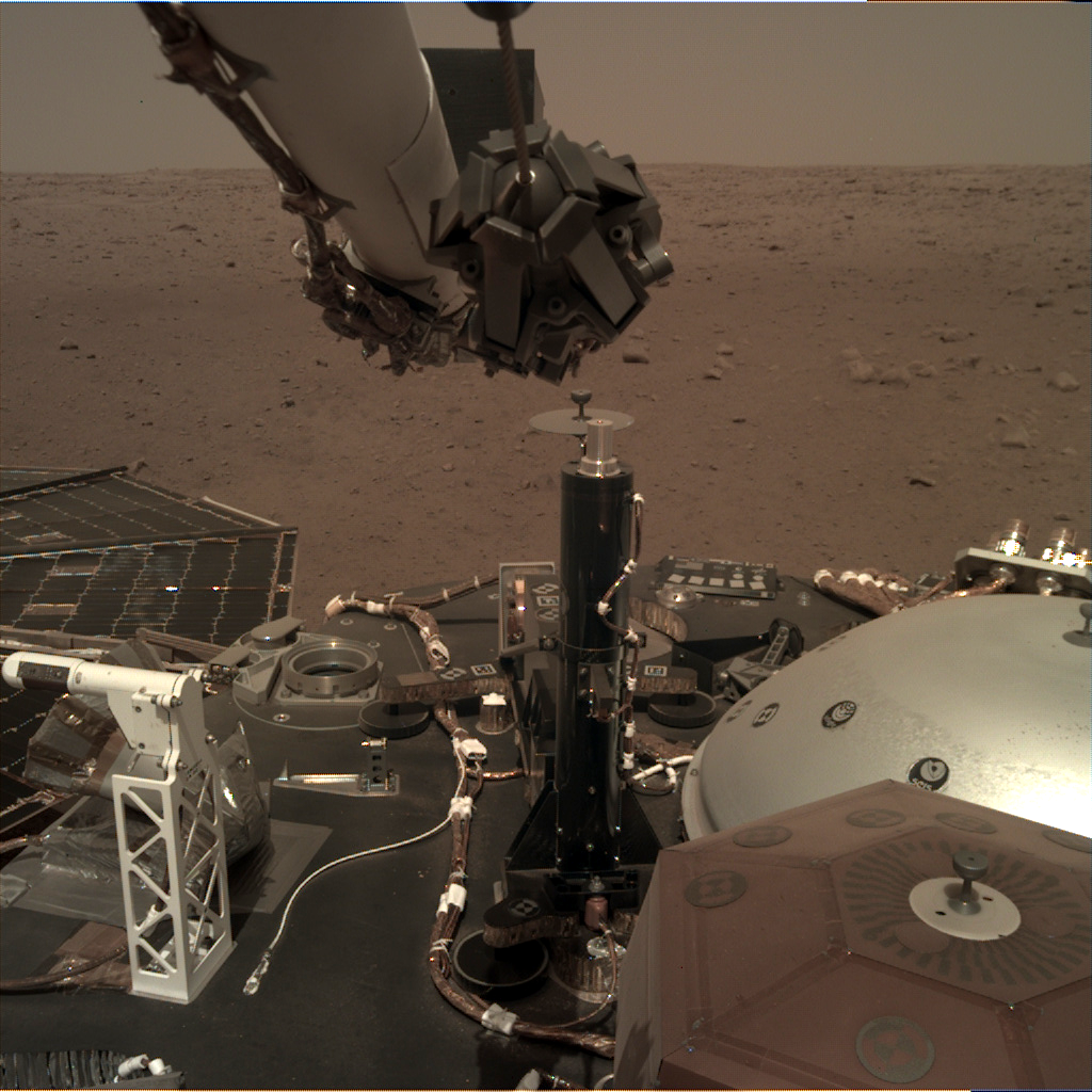
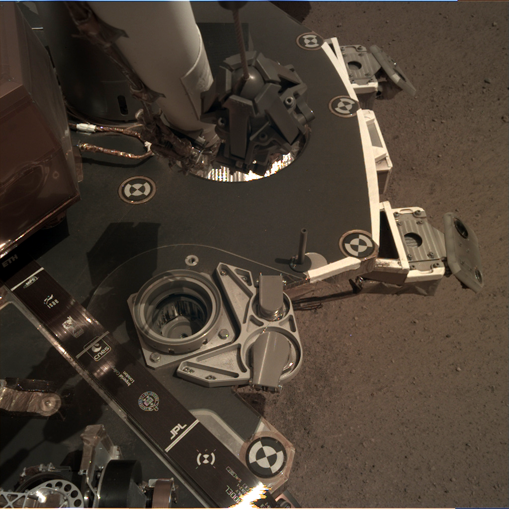
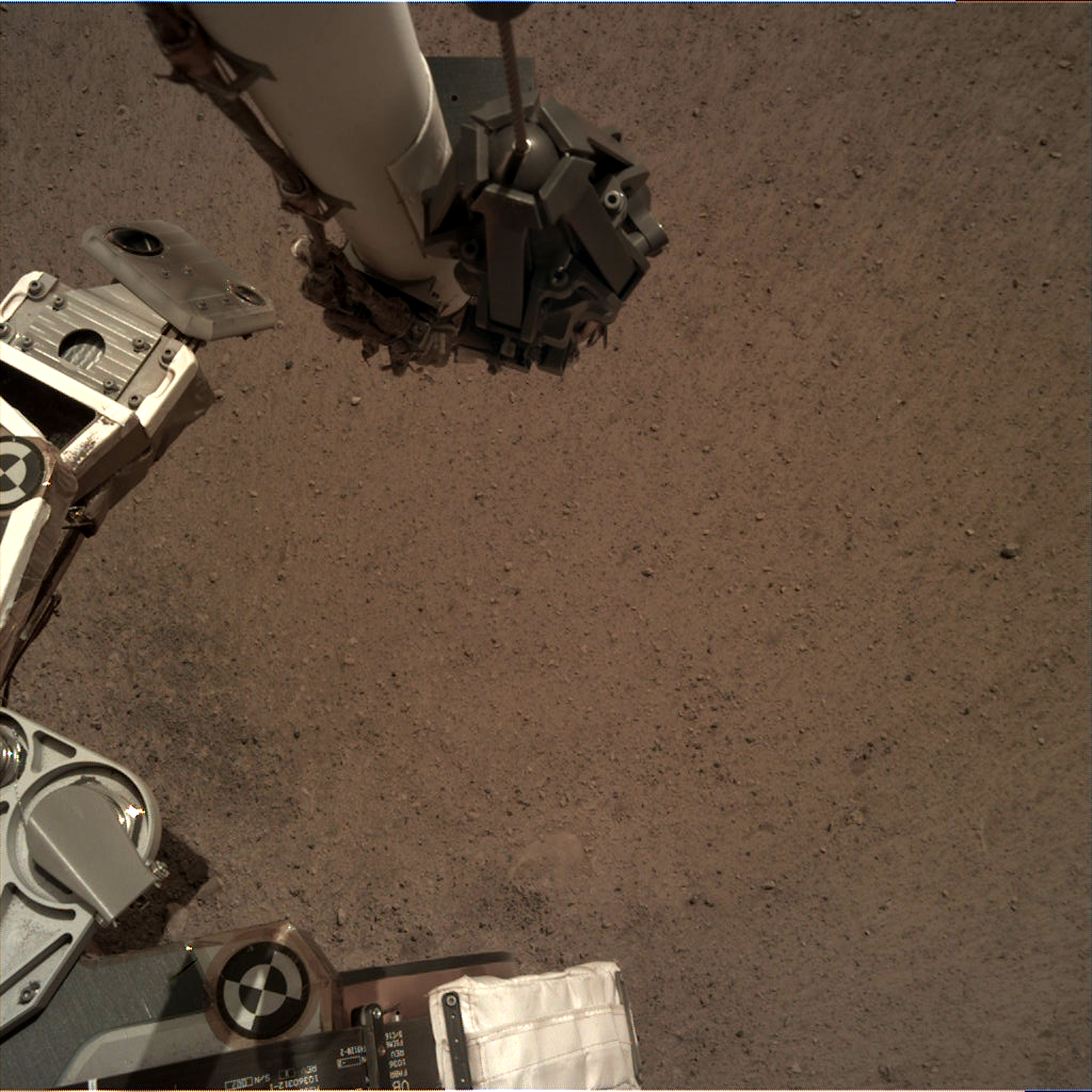
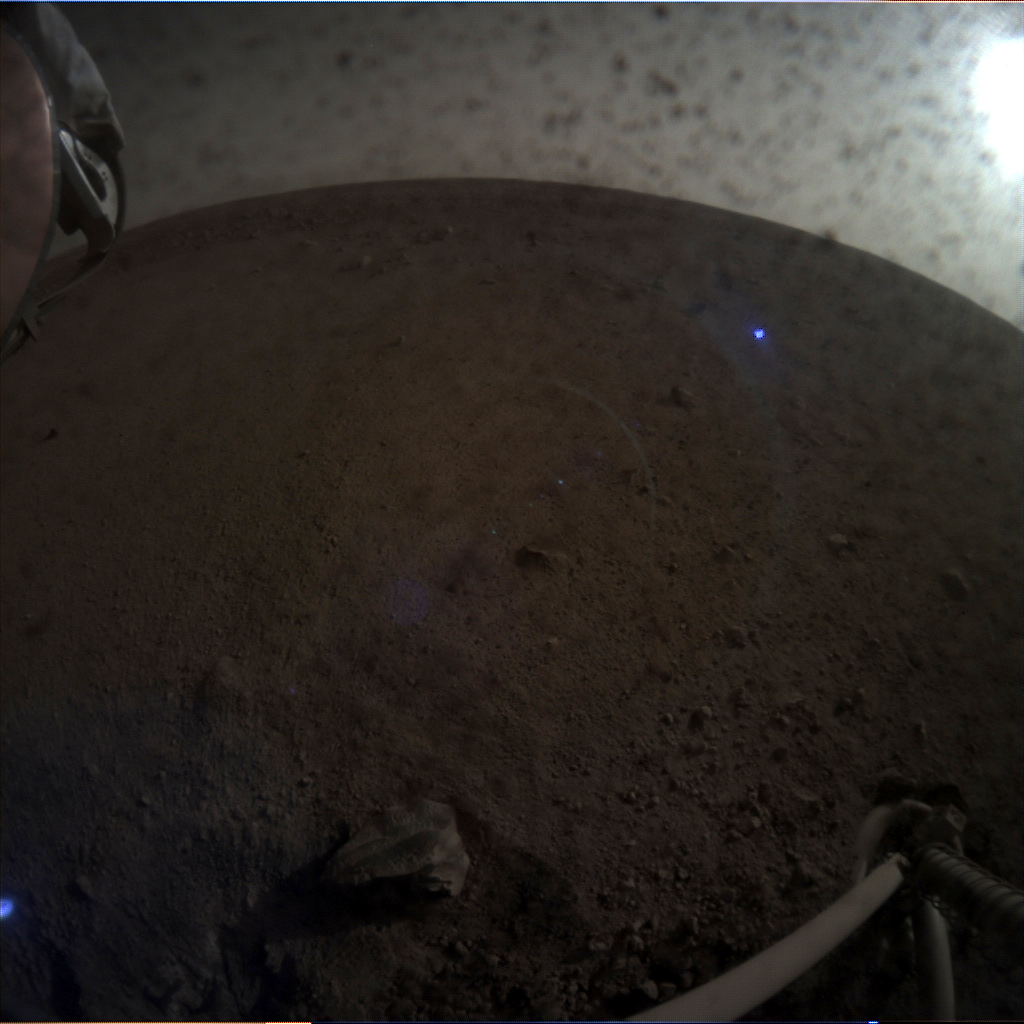
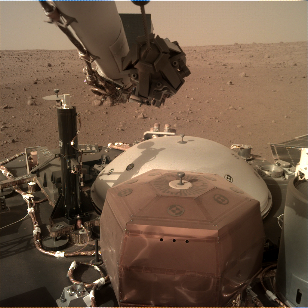
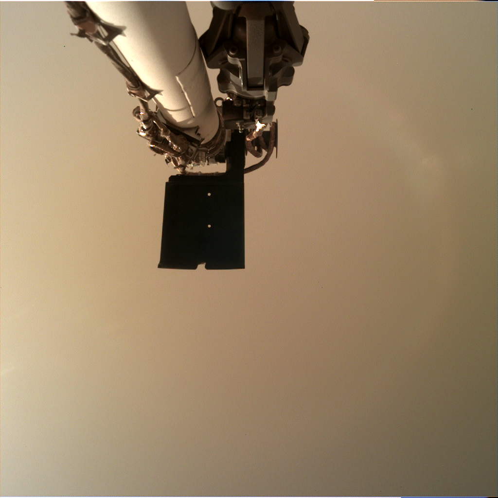
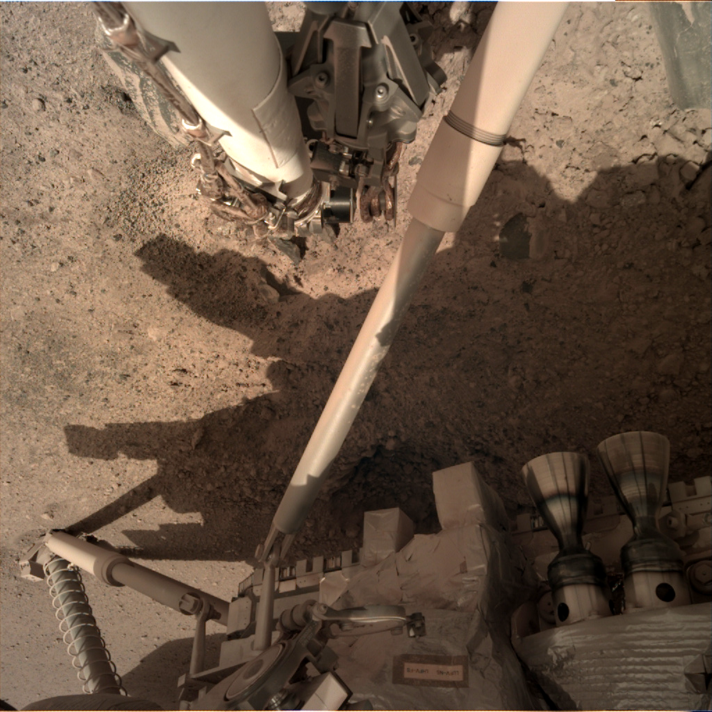
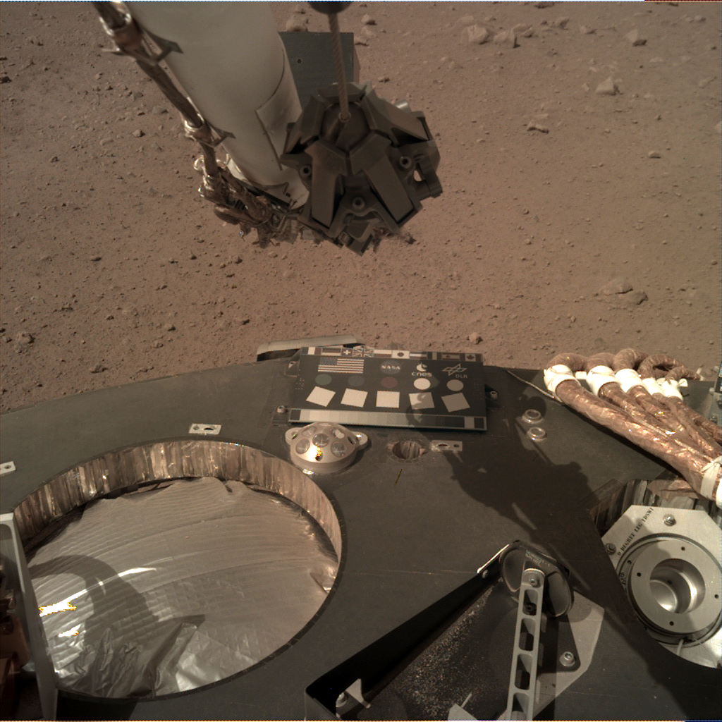
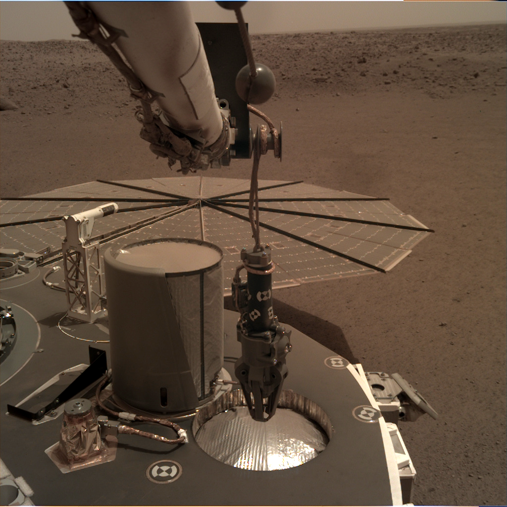
Sol 10: Nieuwe foto's laten zien dat de robotarm van Insight klaar is voor gebruik.
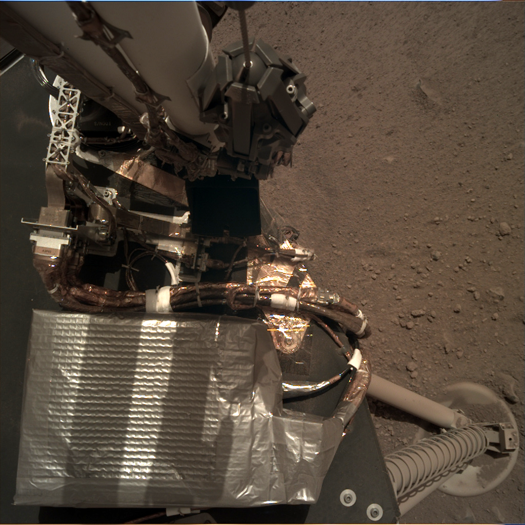
Met een bereik van 2 meter, zal de robotarm de instrumenten van het landingsdek optillen en op de Marsbodem zetten.Echter, eerst zal de instrument deployment camera (bevestigd aan de elleboog van de robotarm) foto's maken van het terrein voor InSight. Na analyse van deze foto's zal bepaald gaan worden waar de seismometer en de thermometer geplaatst zullen gaan worden.
Vandaag zien we een eerst glimp van onze "werkplek". Begin volgende week zal men gedetailleerdere foto's gaan maken.
Op een andere camera - instrument context camera- , bevestigd aan de onderkant van de lander, zal ook beelden van de werkplek laten zien. Echter, op de een of andere manier is er toch stof op de lens gekomen, ondanks de bescherming die we op de context camera hadden gezet. Zo zei Tom Hoffman van JPL, de project manager van InSight.
Hoewel dit jammer is, zal het de taak van de camera niet beïnvloeden, namelijk het maken van foto's van het gebied voor InSight, waar de instrumenten geplaatst zullen gaan worden.
Aangezien het plaatsen en kalibreren van de instrumenten heel secuur gedaan moet worden, zal dit 2- 3 maanden in beslag gaan nemen.
De afgelopen anderhalve week is men bezig geweest met het testen van de instrumenten en de systemen, om er zeker van te zijn dat alles functioneert. Enkele instrumenten (zoals de luchtdruk sensor) zijn al data aan het opnemen. Hierop is te zien dat er een daling in de luchtdruk is geweest, waarschijnlijk veroorzaakt door een stofhoos.
Deze luchtdruksensor, samen met de magnetometer en een set van wind en temperatuursensoren, vormen samen het "Auxiliary Payload Sensor subsysteem, die de metereologische data zal verzamlen.
Op de planning van dit weekend staat het maken van meer foto's door InSight. Hoewel op dit moment het maken van de foto's is onderbroken, zal Insight hier morgen weer mee verder gaan.
Gedurende de eerste weken heeft InSight de instructies gekregen extra voorzichtig te werk te gaan, zodat bij een onverwachte trigger InSight stopt met wat hij op dat moment aan het doen is en aan de operators om hulp wordt gevraagd.
We hebben op aarde intensief getest, maar aangezien alles net een beetje anders is op Mars, zijn deze fouten niet ongewoon, zo zei Hoffman. Het kan vertraging opleveren, maar we hebben geen haast. We willen dat elke operatie veilig en goed verloopt.
"We did extensive testing on Earth. But we know that everything is a little different for the lander on Mars, so faults are not unusual," Hoffman said.
De missie duurt 1 mars jaar, 2 jaren op aarde, dus er is tijd genoeg om data te verzamelen van het Marsoppervlak.
Bron: https://mars.nasa.gov


Credit: NASA/JPL-Caltech.


Hoe gaat het in de tussentijd op Mars?
InSight:
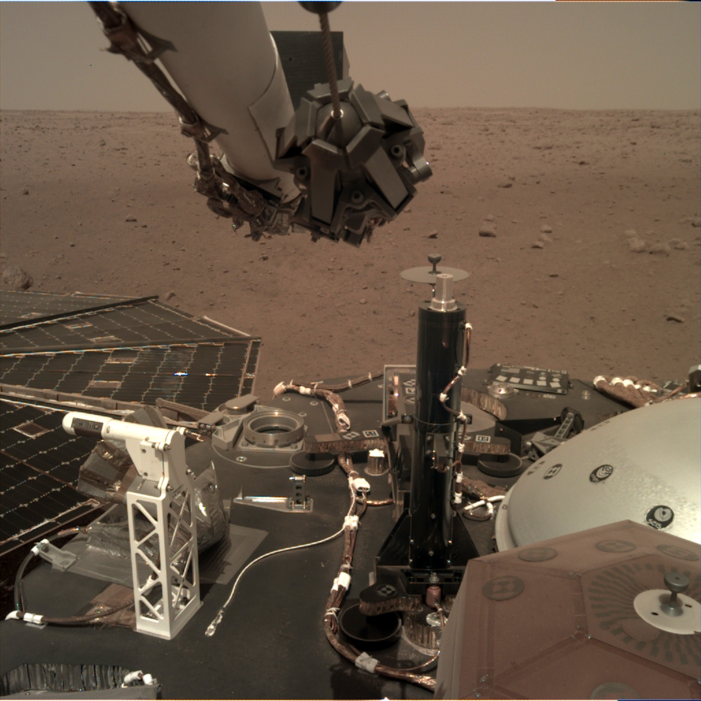
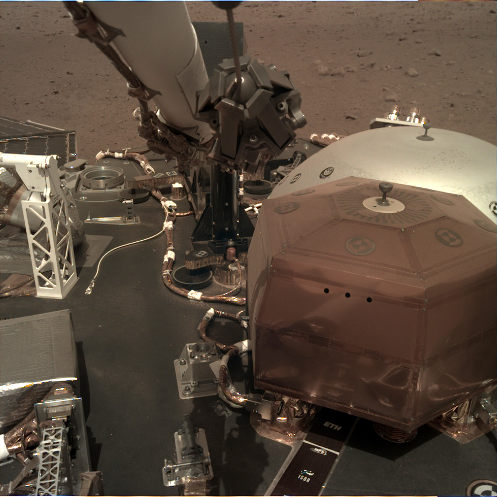
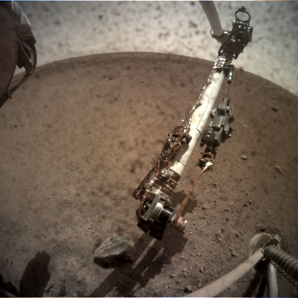
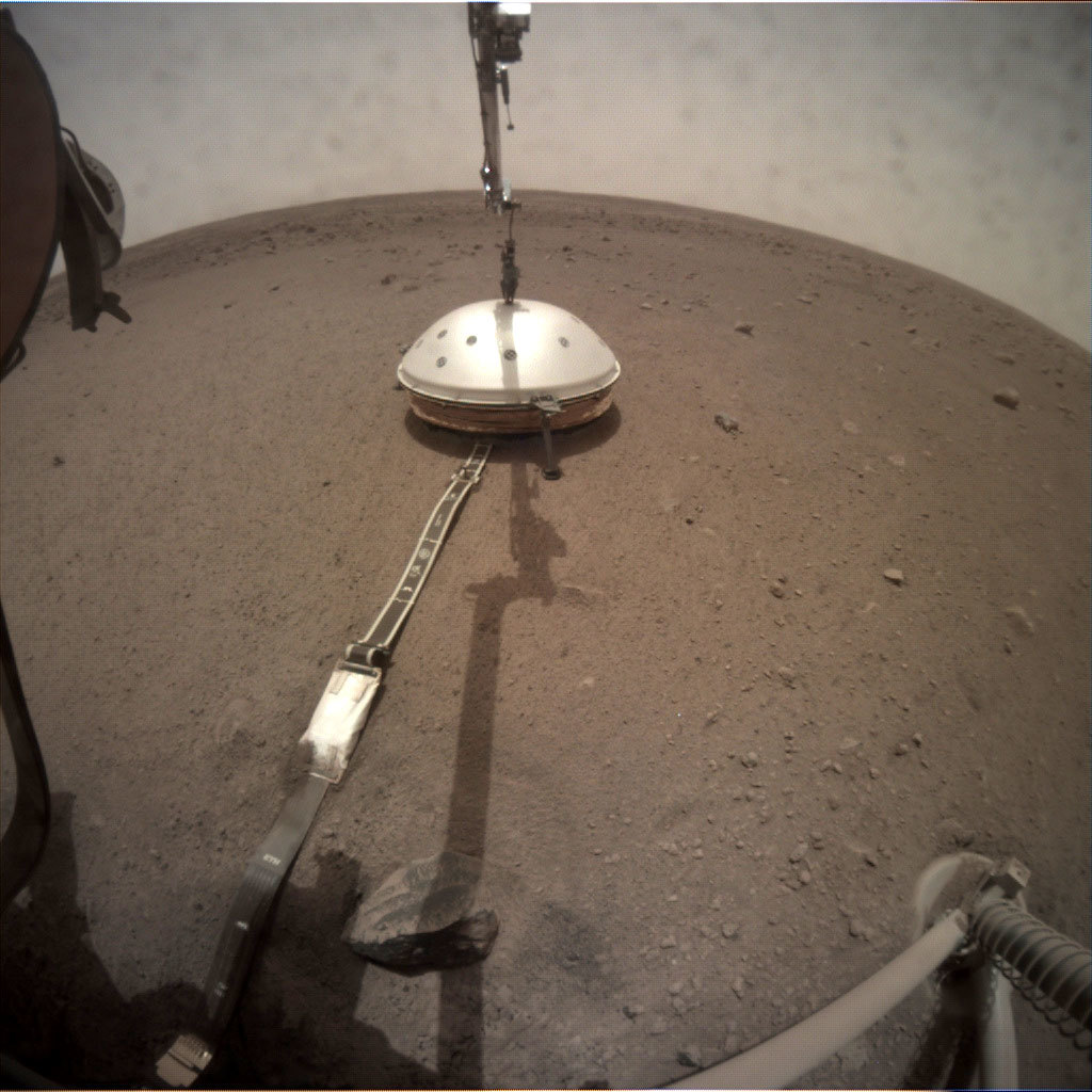
Op 19 december werd de seismometer- SEIS genoemd - op Mars geplaatst en daar is sinds 2 februari nog een nieuwe mijlpaal bijgekomen: Het beschermingsschild is geplaatst. Dit schild heeft de vorm van een koepel en moet de seismograaf beschermen tegen wind en de temperaturen op Mars. De temperaturen fluctueren erg daar waar Insight is geland en dit verschil kan oplopen tot zo'n 94 graden Celcius .Doordat het schild de vorm van een koepel heeft, zal deze niet om kunnen waaien. De wind duwt de koepel als het ware naar beneden.
Op aarde worden seismometers regelmatig ingegraven, zodat dit bescherming biedt. Omdat dit op Mars niet kan, is de koepel de eerste bescherming. Daarnaast is SEIS zo gemaakt, dat wanneer hij zowel kan uitzetten als inkrimpen. Zet het aan de ene kant uit, dan krimpt hij aan de andere kant, zodat de effecten als het waren worden opgeheven. De seismometer zit als het ware verpakt in een vacuum gesealde titanium bal. En als laatste zit de seismometer in een hexagonale doos. De honingraden zijn gevuld met cellen die lucht vasthouden en deze ervan weerhoudt te bewegen.
Indien de seismometer alsnog trillingen oppakt, die "er niet bij horen" zullen de weersensoren dit ook detecteren en deze zullen door de wetenschappers eruit worden gefilterd.
Met de seismometer klaar voor gebruik, zal komende week het volgende op het programma staan: het opzetten van Heat Flow and Physical Properties Package (HP3).
NASA/JPL-Caltech
NASA/JPL-Caltech
NASA/JPL-Caltech
En hoe gaat het met EVE and WALL-E (MarCo)?
Zij hebben hun taken met succes volbracht:Wall-E:
- Tijdens de landing van InSight zorgde hij voor de communicatie
- Hij stuurde de data terug van elke fase van de landing en dat bijna in real- time
- Hij stuurde de eerste foto die InSight maakte door
- En maakte prachtige foto's van Mars
- heeft zich bezig gehouden met eenvoudige radio wetenschappen
Het team heeft verschillende verklaringen waarom dit zou kunnen zijn:
- Wall-E had een lekkende stuurrakket;
- Door problemen met de oriëntatie/ hoogteregelaar kunnen de satellieten gaan "wiebelen", waardoor het verzenden en ontvangen van gegevens niet goed gaat;
- en een andere factor kan zijn dat de sensoren die ervoor moeten zorgen dat de satellieten naar de zon gericht staan, zodat de batterijen opgeladen kunnen worden, niet meer functioneren.
Pas tegen de zomer, gaan Wall-E en Eve pas weer richting de zon. Het team gaat dan opnieuw proberen contact met ze te leggen. Maar of ze dan überhaupt nog functioneren is maar de vraag.
Indien dat niet meer zou gebeuren is de missie van Wall-E en Eve een groot succes gebleken. Het doel was om te kijken hoever men kon gaan met deze geminiaturiseerde technologie en de grenzen ervan opzoeken. Nasa zal in de komende jaren nog meer Cubesats gaan lanceren.

MarCO-B (Wall-E) approaches Mars: MarCO-B, one of the experimental Mars Cube One (MarCO) CubeSats, took these images as it approached Mars. Image Credit: NASA/JPL-Caltech
Bron: https://mars.nasa.gov/insight/
Update over InSight.
Sorry, ik loop achter met de updates. Pak er een kopje koffie of thee bij, want hier komt het nodige "leesvoer". Ik zal voor elke artikel een nieuw bericht maken, dat houdt het geheel wat overzichtelijker.
NASA's InSight Prepares to Take Mars' Temperature.

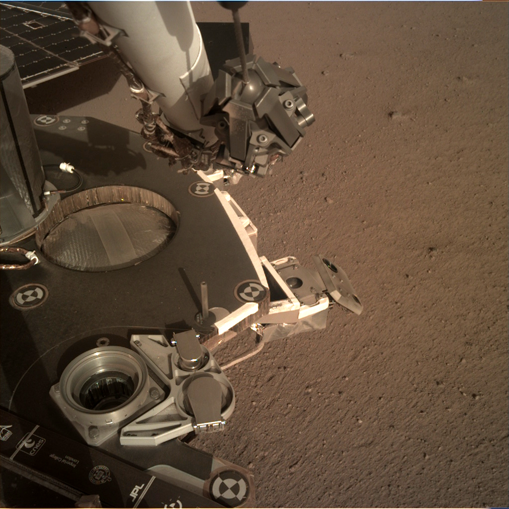
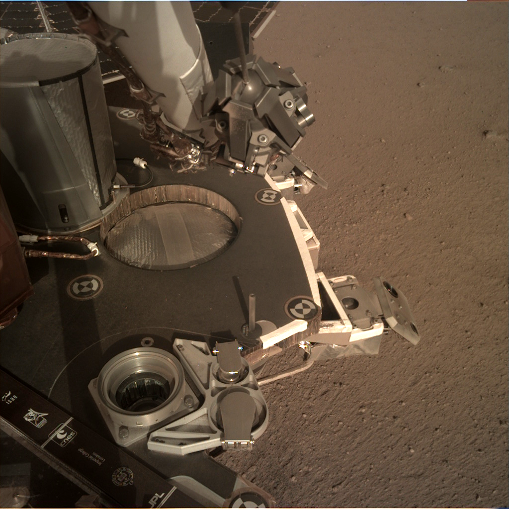
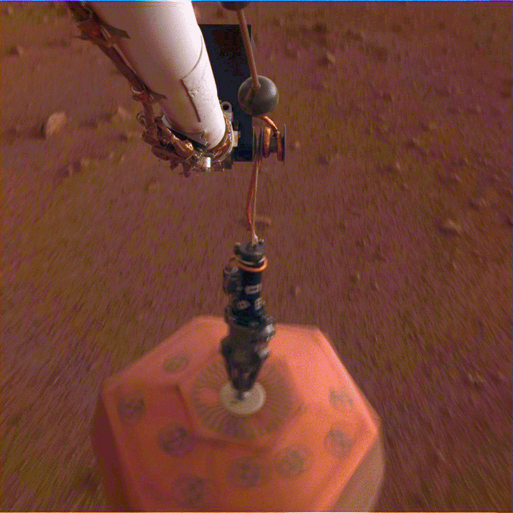
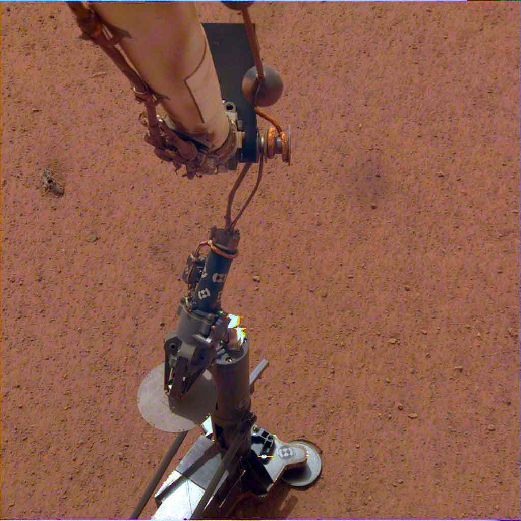
HP3 on the Martian Surface: NASA's InSight lander set its heat probe, called the Heat and Physical Properties Package (HP3), on the Martian surface on Feb. 12. Image Credit: NASA/JPL-Caltech/DLR. Full image and caption ›
Updated at 11 a.m. PST (2 p.m. EST) on March 7: The cooling duration and temperatures in the sixth paragraph have been edited for accuracy.
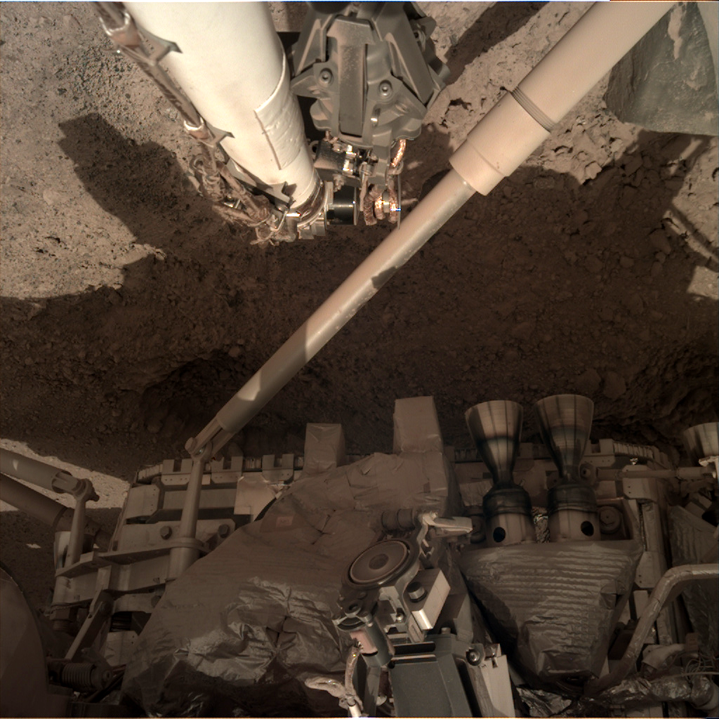
NASA's InSight lander has placed its second instrument on the Martian surface. New images confirm that the Heat Flow and Physical Properties Package, or HP3, was successfully deployed on Feb. 12 about 3 feet (1 meter) from InSight's seismometer, which the lander recently covered with a protective shield. HP3 measures heat moving through Mars' subsurface and can help scientists figure out how much energy it takes to build a rocky world.
Equipped with a self-hammering spike, mole, the instrument will burrow up to 16 feet (5 meters) below the surface, deeper than any previous mission to the Red Planet. For comparison, NASA's Viking 1 lander scooped 8.6 inches (22 centimeters) down. The agency's Phoenix lander, a cousin of InSight, scooped 7 inches (18 centimeters) down.
"We're looking forward to breaking some records on Mars," said HP3 Principal Investigator Tilman Spohn of the German Aerospace Center (DLR), which provided the heat probe for the InSight mission. "Within a few days, we'll finally break ground using a part of our instrument we call the mole."
HP3 looks a bit like an automobile jack but with a vertical metal tube up front to hold the 16-inch-long (40-centimeter-long) mole. A tether connects HP3's support structure to the lander, while a tether attached to the top of the mole features heat sensors to measure the temperature of the Martian subsurface. Meanwhile, heat sensors in the mole itself will measure the soil's thermal conductivity — how easily heat moves through the subsurface.

HP3 Being Tested in Germany: InSight's heat probe, called the Heat and Physical Properties Package (HP3). Image Credit: NASA/JPL-Caltech/DLR. Full image and caption ›"Our probe is designed to measure heat coming from the inside of Mars," said InSight Deputy Principal Investigator Sue Smrekar of NASA's Jet Propulsion Laboratory in Pasadena, California. "That's why we want to get it belowground. Temperature changes on the surface, both from the seasons and the day-night cycle, could add 'noise' to our data."
The mole will stop every 19 inches (50 centimeters) to take a thermal conductivity measurement of the soil. Because hammering creates friction and releases heat, the mole is first allowed to cool down for a about three days. Then it will be heated up by about 18 degrees Fahrenheit over 24 hours. Temperature sensors within the mole measure how rapidly this happens, which tells scientists the conductivity of the soil.
Between the careful burrowing action, the pauses and the time required for the science team to send commands to the instrument, more than a month will go by before the mole reaches its maximum depth. If the mole extends as far as it can go, the team will need only a few months of data to figure out Mars' internal temperature.
If the mole encounters a large rock before reaching at least 10 feet (3 meters) down, the team will need a full Martian year (two Earth years) to filter noise out of their data. This is one reason the team carefully selected a landing site with few rocks and why it spent weeks choosing where to place the instrument.

HP3 Cutaway Rendering: An artist's concept of InSight's heat probe, called the Heat and Physical Properties Package (HP3), annotates various parts inside of the instrument. Image Credit: NASA/JPL-Caltech/DLR. Full image and caption ›"We picked the ideal landing site, with almost no rocks at the surface," said JPL's Troy Hudson, a scientist and engineer who helped design HP3. "That gives us reason to believe there aren't many large rocks in the subsurface. But we have to wait and see what we'll encounter underground."
However deep it gets, there's no debating that the mole is a feat of engineering.
"That thing weighs less than a pair of shoes, uses less power than a Wi-Fi router and has to dig at least 10 feet [3 meters] on another planet," Hudson said. "It took so much work to get a version that could make tens of thousands of hammer strokes without tearing itself apart; some early versions failed before making it to 16 feet [5 meters], but the version we sent to Mars has proven its robustness time and again."
About InSight
JPL manages InSight for NASA's Science Mission Directorate. InSight is part of NASA's Discovery Program, managed by the agency's Marshall Space Flight Center in Huntsville, Alabama. Lockheed Martin Space in Denver built the InSight spacecraft, including its cruise stage and lander, and supports spacecraft operations for the mission.
A number of European partners, including France's Centre National d'Études Spatiales (CNES) and the German Aerospace Center (DLR), are supporting the InSight mission. CNES and the Institut de Physique du Globe de Paris (IPGP) provided the Seismic Experiment for Interior Structure (SEIS) instrument, with significant contributions from the Max Planck Institute for Solar System Research (MPS) in Germany; the Swiss Federal Institute of Technology (ETH Zurich) in Zurich, Switzerland; Imperial College London and Oxford University in the United Kingdom; and JPL. DLR provided the Heat Flow and Physical Properties Package instrument, with significant contributions from the Space Research Center (CBK) of the Polish Academy of Sciences and Astronika in Poland. Spain’s Centro de Astrobiología (CAB) supplied the temperature and wind sensors.
Bron: mars.nasa.gov
NASA's MAVEN Spacecraft Shrinking its Mars Orbit to Prepare for Mars 2020 Rover
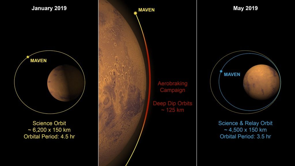
MAVEN Aerobraking to Achieve Science and Relay Orbit: Aerobraking plan for MAVEN.
Image Credit: NASA’s Scientific Visualization Studio/Kel Elkins and Dan Gallagher. Full image and caption.
NASA’s 4-year-old atmosphere-sniffing Mars Atmosphere and Volatile Evolution (MAVEN) mission is embarking on a new campaign today to tighten its orbit around Mars. The operation will reduce the highest point of the MAVEN spacecraft’s elliptical orbit from 3,850 to 2,800 miles (6,200 to 4,500 kilometers) above the surface and prepare it to take on additional responsibility as a data-relay satellite for NASA’s Mars 2020 rover, which launches next year.
“The MAVEN spacecraft has done a phenomenal job teaching us how Mars lost its atmosphere and providing other important scientific insights on the evolution of the Martian climate,” said Jim Watzin, director of NASA's Mars Exploration Program. “Now we’re recruiting it to help NASA communicate with our forthcoming Mars rover and its successors.”
While MAVEN’s new orbit will not be drastically shorter than its present orbit, even this small change will significantly improve its communications capabilities. “It’s like using your cell phone,” said Bruce Jakosky, MAVEN principal investigator from the University of Colorado, Boulder. “The closer you are to a cell tower, the stronger your signal.”
A strong telecommunications antenna signal is not the only benefit of a tighter orbit. Coming in nearly 1,000 miles (about 1,500 kilometers) closer also will allow the MAVEN orbiter to circle Mars more frequently — 6.8 orbits per Earth day versus 5.3 previously — and thus communicate with the Mars rovers more frequently. While not conducting relay communications, MAVEN will continue to study the structure and composition of the upper atmosphere of Mars. “We’re planning a vigorous science mission far into the future,” Jakosky said.
The MAVEN mission was designed to last two years in space, but the spacecraft is still operating normally. With the mission managing its fuel to last through 2030, NASA plans to use MAVEN's relay capability as long as possible. The MAVEN orbiter carries an ultra high-frequency radio transceiver — similar to transceivers carried on other Mars orbiters — that allows it to relay data between Earth and rovers or landers on Mars. The MAVEN spacecraft already has served occasionally as NASA’s communication liaison with the Curiosity rover.
Over the next few months, MAVEN engineers will use a navigation technique known as aerobraking — like applying the brakes on a car — to take advantage of the drag of the Red Planet’s upper atmosphere to slow the spacecraft down gradually, orbit by orbit. This is the same drag you would feel if you put your hand out of the window of a moving car.
Based on the tracking of the spacecraft by the navigation team at NASA’s Jet Propulsion Laboratory in Pasadena, California, and at Lockheed Martin in Littleton, Colorado, engineers will begin carefully lowering the lowest part of the spacecraft’s orbit into the Martian upper atmosphere over the next couple of days by firing its thrusters. The spacecraft will circle Mars at this lower altitude about 360 times over the next 2.5 months, slowing down slightly with each pass through the atmosphere. While it may seem like a time-consuming process, aerobraking is the most efficient way to change the spacecraft’s trajectory, said Jakosky: “The effect is the same as if we fired our thrusters a little bit on every orbit, but this way, we use very little fuel.”
Fortunately, the team has ample experience operating the spacecraft at these lower altitudes. On nine previous occasions throughout the mission, MAVEN engineers have dipped the orbiter into the same altitude targets for aerobraking to take measurements of the Martian atmosphere. As a result of these “deep dips” and other measurements, NASA has learned that solar wind and radiation had stripped Mars of most of its atmosphere, changing the planet’s early climate from warm and wet to the dry environment we see today. MAVEN also discovered two new types of auroras on Mars and the presence of charged metal atoms in its upper atmosphere that tell us that a lot of debris is hitting Mars that may affect its climate.
MAVEN’s principal investigator is based at the University of Colorado’s Laboratory for Atmospheric and Space Physics, Boulder. The university provided two science instruments and leads science operations, as well as education and public outreach, for the mission. NASA’s Goddard Space Flight Center in Greenbelt, Maryland, manages the MAVEN project and provided two science instruments for the mission. Lockheed Martin built the spacecraft and is responsible for mission operations. The University of California at Berkeley’s Space Sciences Laboratory also provided four science instruments for the mission. NASA’s Jet Propulsion Laboratory in Pasadena, California, provides navigation and Deep Space Network support, as well as the Electra telecommunications relay hardware and operations.
Bron: http://mars.nasa.gov
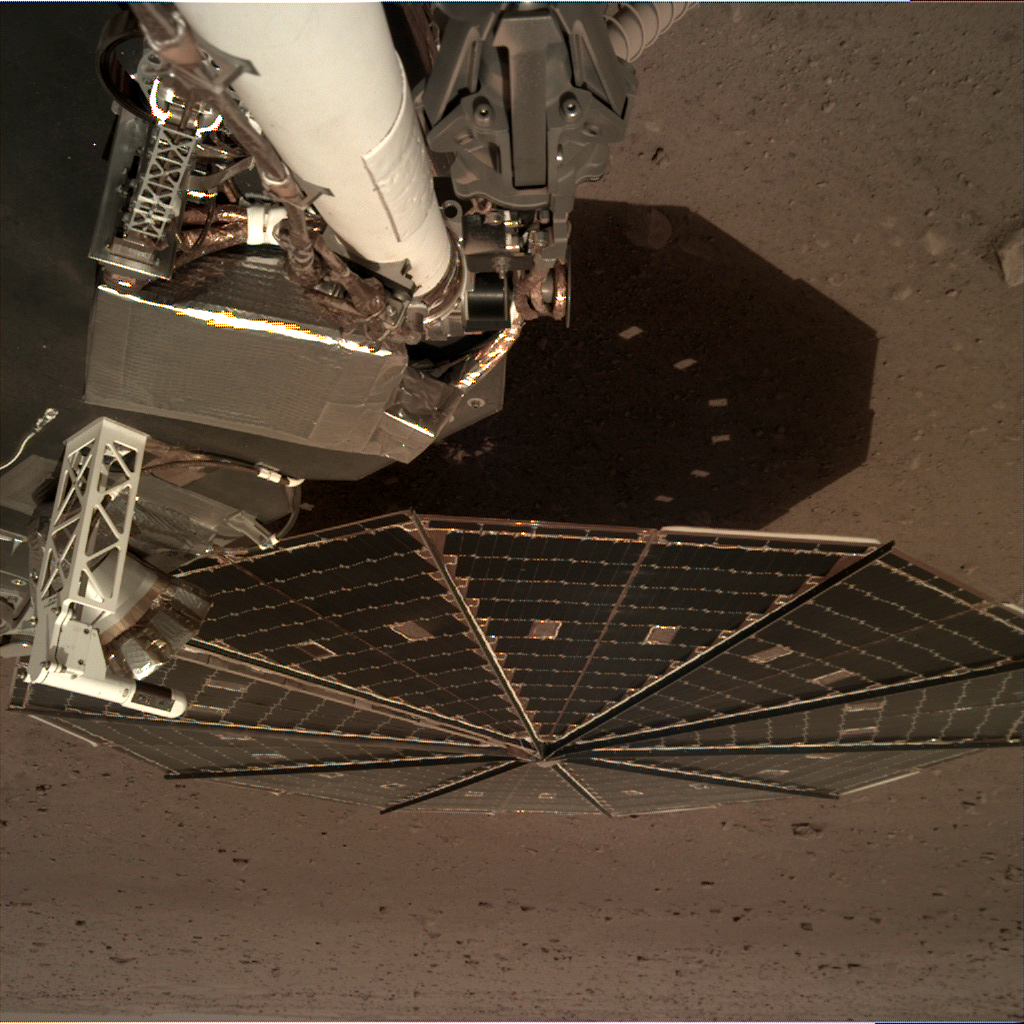
InSight Is the Newest Mars Weather Service.

InSight's First Selfie: The white east- and west-facing booms — called Temperature and Wind for InSight, or TWINS — on the deck of NASA's InSight lander belong to its suite of weather sensors. Image Credit: NASA/JPL-Caltech
No matter how cold your winter has been, it's probably not as chilly as Mars. Check for yourself: Starting today, the public can get a daily weather report from NASA's InSight lander.
This public tool includes stats on temperature, wind and air pressure recorded by InSight. Sunday's weather was typical for the lander's location during late northern winter: a high of 2 degrees Fahrenheit (-17 degrees Celsius) and low of -138 degrees Fahrenheit (-95 degrees Celsius), with a top wind speed of 37.8 mph (16.9 m/s) in a southwest direction. The tool was developed by NASA's Jet Propulsion Laboratory in Pasadena, California, with partners at Cornell University and Spain's Centro de Astrobiología. JPL leads the InSight mission.
Through a package of sensors called the Auxiliary Payload Subsystem (APSS), InSight will provide more around-the-clock weather information than any previous mission to the Martian surface. The lander records this data during each second of every sol (a Martian day) and sends it to Earth on a daily basis. The spacecraft is designed to continue that operation for at least the next two Earth years, allowing it to study seasonal changes as well.
The tool will be geeky fun for meteorologists while offering everyone who uses it a chance to be transported to another planet.
"It gives you the sense of visiting an alien place," said Don Banfield of Cornell University, in Ithaca, New York, who leads InSight's weather science. "Mars has familiar atmospheric phenomena that are still quite different than those on Earth."
Constantly collecting weather data allows scientists to detect sources of "noise" that could influence readings from the lander's seismometer and heat flow probe, its main instruments. Both are affected by Mars' extreme temperature swings. The seismometer, called the Seismic Experiment for Interior Structure (SEIS), is sensitive to air pressure changes and wind, which create movements that could mask actual marsquakes.
"APSS will help us filter out environmental noise in the seismic data and know when we're seeing a marsquake and when we aren't," Banfield said. "By operating continuously, we'll also see a more detailed view of the weather than most surface missions, which usually collect data only intermittently throughout a sol."
APSS includes an air pressure sensor inside the lander and two air temperature and wind sensors on the lander's deck. Under the edge of the deck is a magnetometer, provided by UCLA, which will measure changes in the local magnetic field that could also influence SEIS. It is the first magnetometer ever placed on the surface of another planet.
InSight will provide a unique data set that will complement the weather measurements of other active missions, including NASA's Curiosity rover and orbiters circling the planet. InSight's air temperature and wind sensors are actually refurbished spares originally built for Curiosity's Rover Environmental Monitoring Station (REMS). These two east- and west-facing booms sit on the lander's deck and are called Temperature and Wind for InSight (TWINS), provided by Spain's Centro de Astrobiología.
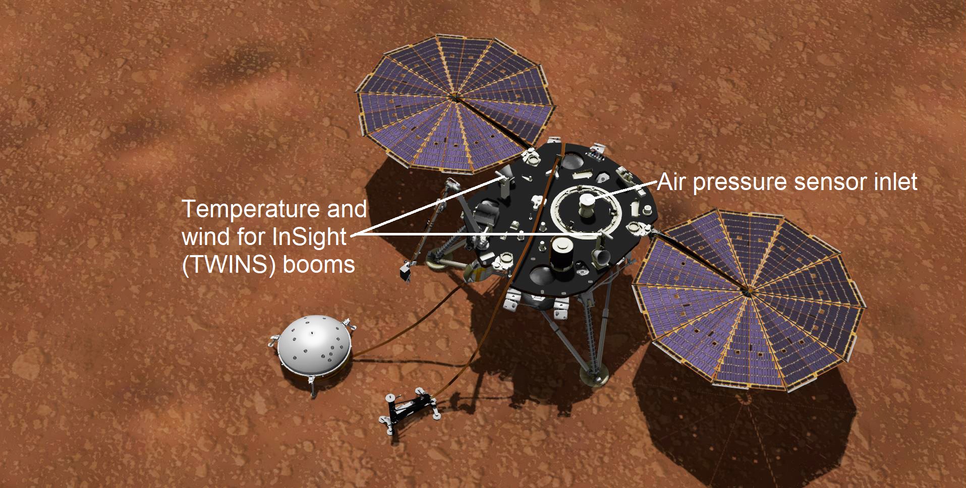
This artist's concept shows NASA's InSight lander with its instruments deployed on the Martian surface. Several of the sensors used for studying Martian weather are visible on its deck, including the inlet for an air pressure sensor and the east- and west-facing weather sensor booms. Image Credit: NASA/JPL-Caltech. Full image and caption ›TWINS will be used to tell the team when strong winds could interfere with small seismic signals. But it could also be used, along with InSight's cameras, to study how much dust and sand blow around. Scientists don't know how much wind it takes to lift dust in Mars' thin atmosphere, which affects dune formation and dust storms — including planet-encircling dust storms like the one that occurred last year, effectively ending the Opportunity rover's mission.
APSS will also help the mission team learn about dust devils that have left streaks on the planet's surface. Dust devils are essentially low-pressure whirlwinds, so InSight's air pressure sensor can detect when one is near. It's highly sensitive — 10 times more so than equipment on the Viking and Pathfinder landers — enabling the team to study dust devils from hundreds of feet (dozens of meters) away.
"Our data has already shown there are a lot of dust devils at our location," Banfield said. "Having such a sensitive pressure sensor lets us see more of them passing by."
Bron: mars.nasa.gov
Mars InSight Lander's 'Mole' Pauses Digging.
HP3 on the Martian Surface: NASA's InSight lander set its heat probe, called the Heat and Physical Properties Package (HP3), on the Martian surface on Feb. 12, 2019. Image Credit: NASA/JPL-Caltech/DLR. Full image and caption ›
Updated at 8 a.m. PDT (11 a.m. EDT) on March 21: More imaging and testing are planned to further study InSight's heat probe, formally known as the Heat and Physical Properties Package (HP3). That testing includes a new round of hammering, which was last attempted March 2. Many ideas for freeing up the mole are being considered, all of which will require at least several more weeks of careful analysis.
There is still little clarity as to whether the "mole" — the nickname for the self-hammering spike that is part of HP3 — is being blocked by a single rock or a layer of gravel. There is also the possibility that the probe or its cable might be stuck on something inside the instrument's protective housing.
Scientists had hoped to get the probe into the ground within a few months of InSight's landing. But so long as it eventually digs at least 10 feet (3 meters) underground, they can get useful science about the Martian interior regardless of when that happens.
Later this month, the team plans to conduct a 10-to-15-minute hammering test. That will allow InSight's seismometer to "listen" to the mole striking whatever obstacle it has hit, offering possible clues as to what may be blocking it. Meanwhile, the camera on InSight's robotic arm will photograph the mole's support structure in the hopes of catching any possible motion induced by the mole during hammering.
In April, a replica of HP3 will be shipped to NASA's Jet Propulsion Laboratory in Pasadena, California. That will allow JPL's team to begin testing in concert with German Aerospace Center (DLR) engineers working with similar models in Bremen, Germany.
Read more at DLR's HP3 blog here:
https://www.dlr.de/blogs/en/all-blog-posts/The-InSight-mission-logbook.aspx
Updated at 11 a.m. PST (2 p.m. EST) on March 7: The temperatures in the fourth paragraph have been edited for accuracy.
NASA's Mars InSight lander has a probe designed to dig up to 16 feet (5 meters) below the surface and measure heat coming from inside the planet. After beginning to hammer itself into the soil on Thursday, Feb. 28, the 16-inch-long (40-centimeter-long) probe — part of an instrument called the Heat and Physical Properties Package, or HP3 — got about three-fourths of the way out of its housing structure before stopping. No significant progress was seen after a second bout of hammering on Saturday, March 2. Data suggests the probe, known as a "mole," is at a 15-degree tilt.
Scientists suspect it hit a rock or some gravel. The team had hoped there would be relatively few rocks below ground, given how few appear on the surface beside the lander. Even so, the mole was designed to push small rocks aside or wend its way around them. The instrument, which was provided for InSight by the German Aerospace Center (DLR), did so repeatedly during testing before InSight launched.
"The team has decided to pause the hammering for now to allow the situation to be analyzed more closely and jointly come up with strategies for overcoming the obstacle," HP3 Principal Investigator Tilman Spohn of DLR wrote in a blog post. He added that the team wants to hold off from further hammering for about two weeks.
Data show that the probe itself continues to function as expected: After heating by about 18 degrees Fahrenheit, it measures how quickly that heat dissipates in the soil. This property, known as thermal conductivity, helps calibrate sensors embedded in a tether trailing from the back of the mole. Once the mole is deep enough, these tether sensors can measure Mars' natural heat coming from inside the planet, which is generated by radioactive materials decaying and energy left over from Mars' formation.
The team will be conducting further heating tests this week to measure the thermal conductivity of the upper surface. They will also use a radiometer on InSight's deck to measure temperature changes on the surface. Mars' moon Phobos will pass in front of the Sun several times this week; like a cloud passing overhead, the eclipse will darken and cool the ground around InSight.
Bron: mars.nasa.gov
Opportunity's Parting Shot Was a Beautiful Panorama.

Opportunity Legacy Pan: This annotated image is a cropped version of the last 360-degree panorama taken by the Opportunity rover's Pancam from May 13 through June 10, 2018. This annotated view is presented in false color to make some differences between materials easier to see. Image Credit: NASA/JPL-Caltech/Cornell/ASU
Over 29 days last spring, NASA's Mars Exploration Rover Opportunity documented this 360-degree panorama from multiple images taken at what would become its final resting spot in Perseverance Valley. Located on the inner slope of the western rim of Endeavour Crater, Perseverance Valley is a system of shallow troughs descending eastward about the length of two football fields from the crest of Endeavour's rim to its floor.
"This final panorama embodies what made our Opportunity rover such a remarkable mission of exploration and discovery," said Opportunity project manager John Callas of NASA's Jet Propulsion Laboratory in Pasadena, California. "To the right of center you can see the rim of Endeavor Crater rising in the distance. Just to the left of that, rover tracks begin their descent from over the horizon and weave their way down to geologic features that our scientists wanted to examine up close. And to the far right and left are the bottom of Perseverance Valley and the floor of Endeavour crater, pristine and unexplored, waiting for visits from future explorers."
The trailblazing mission ended after nearly 15 years of exploring the surface of Mars, but its legacy will live on. Opportunity's scientific discoveries contributed to our unprecedented understanding of the planet's geology and environment, laying the groundwork for future robotic and human missions to the Red Planet.
The panorama is composed of 354 individual images provided by the rover's Panoramic Camera (Pancam) from May 13 through June 10, or sols (Martian days) 5,084 through 5,111. This view combines images taken through three different Pancam filters. The filters admit light centered on wavelengths of 753 nanometers (near-infrared), 535 nanometers (green) and 432 nanometers (violet).
A few frames (bottom left) remain black and white, as the solar-powered rover did not have the time to record those locations using the green and violet filters before a severe Mars-wide dust storm swept in on June 2018.

Last Images Opportunity Took: These two thumbnail images, with the ghostly dot of a faint Sun near the middle of each, are the last images NASA's Opportunity rover took on Mars. Image Credit: NASA/JPL-Caltech/Cornell/ASU. Full image and caption ›The gallery includes the last images Opportunity obtained during its mission (black-and-white thumbnail images from the Pancam that were used to determine how opaque the sky was on its last day) and also the last piece of data the rover transmitted (a "noisy," incomplete full-frame image of a darkened sky).
Opportunity's Last Message: Taken on June 10, 2018 (the 5,111th Martian day, or sol, of the mission) this “noisy,” incomplete image was the last data NASA's Opportunity rover sent back from Mars. Image Credit: NASA/JPL-Caltech/Cornell/ASU.
After eight months of effort and sending more than a thousand commands in an attempt to restore contact with the rover, NASA declared Opportunity's mission complete on Feb. 13, 2019.
JPL, a division of the California Institute of Technology in Pasadena, managed the Mars Exploration Rover Project for NASA's Science Mission Directorate in Washington.
Bron: mars.nasa.gov
NASA's Mars 2020 Rover Is Put to the Test.

Mars 2020 System Test 1: Technicians working Mars 2020’s System’s Test 1 approach their workstation in the Spacecraft Assembly Facility at NASA’s Jet Propulsion Laboratory in Pasadena, Calif. Image Credit: NASA/JPL-Caltech
In a little more than seven minutes in the early afternoon of Feb. 18, 2021, NASA's Mars 2020 rover will execute about 27,000 actions and calculations as it speeds through the hazardous transition from the edge of space to Mars' Jezero Crater. While that will be the first time the wheels of the 2,314-pound (1,050-kilogram) rover touch the Red Planet, the vehicle's network of processors, sensors and transmitters will, by then, have successfully simulated touchdown at Jezero many times before.
We first landed on Jezero Crater on Jan. 23rd," said Heather Bottom, systems engineer for the Mars 2020 mission at the Jet Propulsion Laboratory in Pasadena, California. "And the rover successfully landed again on Mars two days later."
Bottom was the test lead for Systems Test 1, or ST1, the Mars 2020 engineering team's first opportunity to take the major components of the Mars 2020 mission for a test drive. Over two weeks in January, Bottom and 71 other engineers and technicians assigned to the 2020 mission took over the High Bay 1 cleanroom in JPL's Spacecraft Assembly Facility to put the software and electrical systems aboard the mission's cruise, entry capsule, descent stage and rover through their paces.
"ST1 was a massive undertaking," said Bottom. "It was our first chance to exercise the flight software we will fly on 2020 with the actual spacecraft components that will be heading to Mars — and make sure they not only operate as expected, but also interact with each other as expected."
The heritage for Mars 2020's software goes back to the Mars Exploration Rovers (Spirit and Opportunity) and the Curiosity rover that has been exploring Mars' Gale Crater since 2012. But 2020 is a different mission with a different rover, a different set of science instruments and a different destination on Mars. Its software has to be tailored accordingly.
Work began in earnest on the flight software in 2013. It was coded, recoded, analyzed and tested on computer workstations and laptops. Later, the flight software matriculated to spacecraft testbeds where it was exposed to computers, sensors and other electronic components customized to imitate the flight hardware that will launch with the mission in 2020.
"Virtual workstations and testbeds are an important part of the process," said Bottom. "But the tens of thousands of individual components that make up the electronics of this mission are not all going to act, or react, exactly like a testbed. Seeing the flight software and the actual flight hardware working together is the best way to build confidence in our processes. Test like you fly."
Making the Grade
On the day before ST1 began, the High Bay 1 cleanroom was hopping with "bunny suit"-clad engineers and technicians assembling, inspecting and testing the mission's hardware. The next day, Wednesday, Jan. 16, the room was eerily quiet. The majority of workers had been replaced by two technicians there to monitor the flight test hardware. Lines of electrical cabling — "umbilicals" — were added to provide data and power to the spacecraft's cruise stage, back shell, descent stage and rover chassis, which have yet to be stacked together. The ground to in-flight spacecraft (and in-flight spacecraft to ground) communications were handled by X-band radio transmission, just like they would be during the trip to Mars.
ST1 began with commands to energize the spacecraft's electrical components and set up thermal, power and telecom configurations. While all the spacecraft components remained in the cleanroom, Bottom and her team had them thinking they were sitting on top of an Atlas 541 rocket 190 feet (58 meters) above Launch Complex 41 at Cape Canaveral on July 17, 2020, waiting to be shot into space.
Next, they focused on another part of cruise before testing the landing sequence. Then they did it all over again.
After a successful launch, they time jumped 40 days ahead to simulate deep space cruise. How would the software and hardware interact when they had to perform navigation fixes and trajectory correction maneuvers? And how would they work when simulated events didn't go as planned? The team looked for answers on the operators' computer screens in the test operations room beside the cleanroom.
"From the test operations room, you could look out the windows onto the cleanroom floor and clearly see the flight hardware," said Bottom. "Nothing was visibly moving, but underneath the outer structure, there were flight computers swapping sides, radios sending and receiving transmissions, fuel valves moving in and out, subsystems being energized and later turned off, and electrical signals being sent to nonexistent pyrotechnic devices. There was a lot going on in there."
On Jan. 30, the Mars 2020 test team was able to close their 1,000-plus page book of procedures for ST1. They went two-for-two on Mars landings. They also launchedfour times, performed deep space navigation, executed several trajectory correction maneuvers and even tested a few in-flight off-nominal situations.This first evaluation of flight hardware and software, over a year in the making, had been a thorough success, demonstrating where things excelled and where they could be improved. When these new changes have been investigated on both a virtual workstation and in the testbed, they will have their chance to "fly" in one of the many other systems tests planned for Mars 2020.
"One of the future scenario tests will place the rover inside a thermal chamber and simulate being on the surface. It will step through mission critical activities at some very low Mars surface temperatures," said Bottom. "Both literally and figuratively it will be a very cool test."
The Mars 2020 Project at JPL manages rover development for NASA's Science Mission Directorate. NASA's Launch Services Program, based at the agency's Kennedy Space Center in Florida, is responsible for launch management. Mars 2020 will launch from Cape Canaveral Air Force Station in Florida.
Bron: mars.nasa.gov
Asteroids, Hydrogen Make Great Recipe for Life on Mars.
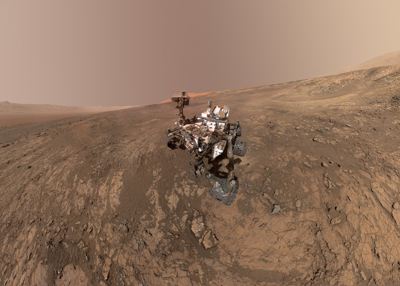
Mount Sharp Photobombs Curiosity: This self-portrait of NASA's Curiosity Mars rover shows the vehicle on Vera Rubin Ridge, which it's been investigating for the past several months. Image Credit: NASA/JPL-Caltech/MSSS.
A new study reveals asteroid impacts on ancient Mars could have produced key ingredients for life if the Martian atmosphere was rich in hydrogen. An early hydrogen-rich atmosphere on Mars could also explain how the planet remained habitable after its atmosphere thinned. The study used data from NASA's Curiosity rover on Mars and was conducted by researchers on Curiosity's Sample Analysis at Mars (SAM) instrument team and international colleagues.
These key ingredients are nitrites (NO2) and nitrates (NO3), fixed forms of nitrogen that are important for the establishment and sustainability of life as we know it. Curiosity discovered them in soil and rock samples it took as it traversed within Gale Crater, the site of ancient lakes and groundwater systems on Mars.
To understand how fixed nitrogen may have been deposited in the crater, researchers needed to recreate the early Martian atmosphere here on Earth. The study, led by Dr. Rafael Navarro-González and his team of scientists at the Institute of Nuclear Sciences of the National Autonomous University of Mexico in Mexico City, used a combination of theoretical models and experimental data to investigate the role hydrogen plays in altering nitrogen into nitrites and nitrates using energy from asteroid impacts. The paper was published in January in the Journal of Geophysical Research: Planets.
In the lab, the group used infrared laser beam pulses to simulate the high-energy shockwaves created by asteroids slamming into the atmosphere. The pulses were focused into a flask containing mixtures of hydrogen, nitrogen and carbon dioxide gases, representing the early Martian atmosphere. After the laser blasts, the resulting concoction was analyzed to determine the amount of nitrates formed. The results were surprising, to say the least.
Laser Blasts Simulate Asteroids: This flask served as part of a laboratory test simulating the effect of asteroids impacting the ancient Martian atmosphere. Image Credit: Rafael Navarro-González.
"The big surprise was that the yield of nitrate increased when hydrogen was included in the laser-shocked experiments that simulated asteroid impacts," said Navarro-González. "This was counterintuitive as hydrogen leads to an oxygen-deficient environment while the formation of nitrate requires oxygen. However, the presence of hydrogen led to a faster cooling of the shock-heated gas, trapping nitric oxide, the precursor of nitrate, at elevated temperatures where its yield was higher."
Although these experiments were conducted in a controlled lab environment millions of miles from the Red Planet, the researchers wanted to simulate the results obtained from Curiosity using the SAM instrument on the rover. SAM takes samples drilled from rock or scooped up from the surface by the rover's mechanical arm and bakes them to look at the chemical fingerprints of the released gases.
"SAM on Curiosity was the first instrument to detect nitrate on Mars," said Christopher McKay, a co-author of the paper at NASA's Ames Research Center in California's Silicon Valley. "Because of the low levels of nitrogen gas in the atmosphere, nitrate is the only biologically useful form of nitrogen on Mars. Thus, its presence in the soil is of major astrobiological significance. This paper helps us understand the possible sources of that nitrate."
Why were the effects of hydrogen so fascinating? Although the surface of Mars is cold and inhospitable today, scientists think that a thicker atmosphere enriched in greenhouse gases such as carbon dioxide and water vapor may have warmed the planet in the past. Some climate models show that the addition of hydrogen in the atmosphere may have been necessary to raise temperatures enough to have liquid water at the surface.
"Having more hydrogen as a greenhouse gas in the atmosphere is interesting both for the sake of the climate history of Mars and for habitability," said Jennifer Stern, a planetary geochemist at NASA's Goddard Space Flight Center in Greenbelt, Maryland, and one of the co-investigators of the study. "If you have a link between two things that are good for habitability — a potentially warmer climate with liquid water on the surface and an increase in the production of nitrates, which are necessary for life — it's very exciting. The results of this study suggest that these two things, which are important for life, fit together and one enhances the presence of the other."
Even though the composition of the early Martian atmosphere remains a mystery, these results may provide more pieces for solving this climate puzzle.
NASA is exploring our solar system and beyond, uncovering worlds, stars and cosmic mysteries near and far with our powerful fleet of space and ground-based missions. Experimental and theoretical work by Navarro-González was funded by the National Autonomous University of Mexico in Mexico City and the National Council of Science and Technology of Mexico. American co-authors received funding from NASA's Mars Science Laboratory project and French co-authors received funding from the National Center for Space Studies (CNES), Paris, France. NASA's Mars Exploration Program for the agency's Science Mission Directorate (SMD) in Washington funded all work related to the operation of the Curiosity rover, the SAM instrument, and the use of NASA facilities and resources to retrieve and analyze the data. Goddard provided the SAM instrument. NASA's Jet Propulsion Laboratory in Pasadena, California, built the rover and manages the project for SMD.
Bron: mars.nasa.gov
NASA's InSight deed mogelijk eerste waarneming van beving op Mars
InSight, de Marslander van NASA, heeft op 6 april voor het eerst een beving gedetecteerd op de rode planeet. De Franse ruimtevaartorganisatie CNES heeft dit dinsdag bekendgemaakt. De waarneming is echter wel te klein om verder onderzoek mogelijk te maken.De beving is op de 128e dag van de missie gedetecteerd door de seismograaf aan boord van de InSight. Het meetinstrument wordt beheerd door de CNES. Het is de eerste keer dat er op Mars eventuele bevingen worden gemeten.
Hoewel onderzoekers ervan uitgaan dat de beving afkomstig is uit het binnenste van Mars, moet dit nog bevestigd worden. Er bestaat namelijk ook een kans dat het bijvoorbeeld een effect van wind is.
CNES meldt echter dat de trilling vergelijkbaar is met bevingen die eerder op de maan zijn gedetecteerd tijdens Apollo-missies. Als het daadwerkelijk gaat om een ondergrondse beving, dan is het de eerste keer dat de InSight dit heeft waargenomen op Mars.
Sound on!???? When listening for marsquakes, our @NASAInSight spacecraft recorded audio with three distinct sounds:
— NASA (@NASA) 23 april 2019
???? Noise from the Martian wind
???? Vibrations on the Red Planet
???? Its robotic arm moving to take pictures
Listen in: https://t.co/QPaEmgsiVW . pic.twitter.com/7ZcC2Ig88I
Seismograaf wordt beschermd door wind- en temperatuurschild
De InSight-missie landde op 26 november 2018 succesvol op Mars. De Marslander heeft verschillende meetinstrumenten aan boord om grondonderzoek uit te voeren.
Naast de seismograaf, die onder een wind- en temperatuurschild staat, heeft de Marslander ook zonnepanelen aan boord en een camera die panoramabeelden kan maken.
Daarnaast beschikt de Marslander nog over een warmtesonde die door middel van grondboringen meet hoe hitte wordt uitgestoten vanaf de kern van de planeet.
Bron: www.nu.nl
Met meerdere metingen van aardbevingen zouden wetenschappers meer kunnen ontdekken over de samenstelling van de kern van Mars. Dit zou vervolgens vergeleken kunnen worden met die van de Aarde, om eventueel iets meer te weten te komen over het onstaan van de planeten.
Eerder W. in t Erland (Winterland)
InSight maakt foto's van zonsopkomst en zonsondergang op Mars.
NASA's InSight lander captured a series of sunrise and sunset images.
NASA's InSight lander used its Instrument Deployment Camera (IDC) on the spacecraft's robotic arm to image this sunrise on Mars on April 24, 2019, the 145th Martian day (or sol) of the mission. This was taken around 5:30 a.m. Mars local time.

NASA's InSight lander used the Instrument Deployment Camera (IDC) on the end of its robotic arm to image this sunset on Mars. This color-corrected version more accurately shows the image as the human eye would see it.
Credits: NASA/JPL-Caltech
A camera on the spacecraft's robotic arm snapped the photos on April 24 and 25, the 145th Martian day, or sol, of the mission. In local Mars time, the shots were taken starting around 5:30 a.m. and then again starting around 6:30 p.m. As a bonus, a camera under the lander's deck also caught clouds drifting across the Martian sky at sunset.
These images are available as both "raw" and color-corrected versions. It's easier to see some details in the raw versions, but the latter more accurately show the images as the human eye would see them. Much farther from Mars than it is from Earth, the Sun appears only about two-thirds the size that it does when viewed from Earth.

NASA's InSight lander used the Instrument Deployment Camera (IDC) on the end of its robotic arm to image this sunset on Mars on April 25, 2019, the 145th Martian day, or sol, of the mission. This was taken around 6:30 p.m. Mars local time.
Credits: NASA/JPL-Caltech

NASA's InSight lander used the Instrument Deployment Camera (IDC) on the end of its robotic arm to image this sunset on Mars. This color-corrected version more accurately shows the image as the human eye would see it.
Credits: NASA/JPL-Caltech
This is actually the second time InSight has captured these daily events: The camera took practice shots on March 2 and 10. "It's been a tradition for Mars missions to capture sunrises and sunsets," said Justin Maki, InSight science team co-investigator and imaging lead at NASA's Jet Propulsion Laboratory in Pasadena, California. "With many of our primary imaging tasks complete, we decided to capture the sunrise and sunset as seen from another world."
The first mission to send back such images was the Viking 1 lander, which captured a sunset on Aug. 21, 1976; Viking 2 captured a sunrise on June 14, 1978. Since then, both sunrises and sunsets have been recorded by the Spirit, Opportunity and Curiosity rovers, among other missions.

NASA's InSight used its Instrument Context Camera (ICC) beneath the lander's deck to image these drifting clouds at sunset. This series of images was taken on April 25, 2019, the 145th Martian day, or sol, of the mission, starting at around 6:30 p.m. Mars local time.
Credits: NASA/JPL-Caltech

NASA's InSight used its Instrument Context Camera (ICC) beneath the lander's deck to image these drifting clouds at sunset. This color-corrected version more accurately shows the image as the human eye would see it.
Credits: NASA/JPL-Caltech
About InSight
JPL manages InSight for NASA's Science Mission Directorate. InSight is part of NASA's Discovery Program, managed by the agency's Marshall Space Flight Center in Huntsville, Alabama. Lockheed Martin Space in Denver built the InSight spacecraft, including its cruise stage and lander, and supports spacecraft operations for the mission.
A number of European partners, including France's Centre National d'Études Spatiales (CNES) and the German Aerospace Center (DLR), are supporting the InSight mission. CNES provided the Seismic Experiment for Interior Structure (SEIS) instrument to NASA, with the principal investigator at IPGP (Institut de Physique du Globe de Paris). Significant contributions for SEIS came from IPGP; the Max Planck Institute for Solar System Research (MPS) in Germany; the Swiss Federal Institute of Technology (ETH Zurich) in Switzerland; Imperial College London and Oxford University in the United Kingdom; and JPL. DLR provided the Heat Flow and Physical Properties Package (HP3) instrument, with significant contributions from the Space Research Center (CBK) of the Polish Academy of Sciences and Astronika in Poland. Spain’s Centro de Astrobiología (CAB) supplied the temperature and wind sensors.
For more about InSight, visit:
https://mars.nasa.gov/insight/
Bron: nasa.gov
NASA Invites Public to Submit Names to Fly Aboard Next Mars Rover (2020)
Although it will be years before the first humans set foot on Mars, NASA is giving the public an opportunity to send their names - stenciled on chips - to the Red Planet with NASA's Mars 2020 rover, which represents the initial leg of humanity's first round trip to another planet. The rover is scheduled to launch as early as July 2020, with the spacecraft expected to touch down on Mars in February 2021
Link:
https://www.jpl.nasa.gov/news/news.php?feature=7407 | Gewijzigd: 22 mei 2019, 14:29 uur, door Joël87
Dont worry, be happy!!
Ethiopische bacteriën suggereren dat leven op Mars tot de mogelijkheden behoorde.
De microben overleven onder omstandigheden zoals die waarschijnlijk lang geleden op Mars voorkwamen.Onderzoekers togen naar het hydrothermale systeem van Dallol, te vinden in het noorden van Ethiopië. “Dit is een exotische, op meerdere manieren extreme omgeving met organismen die gek moeten zijn op hoge temperaturen, hoge zoutgehaltes en een heel lage pH willen ze kunnen overleven,” stelt onderzoeker Felipe Gómez.
Leven
De onderzoekers bestudeerden zoutafzettingen afkomstig van deze hydrothermale bronnen en ontdekten daarin kleine, bolvormige structuren. Nader onderzoek wees uit dat de structuren – die zeer koolstofrijk zijn – een biologische oorsprong hebben.
Extreme omstandigheden
De micro-organismen zijn zo’n 20 keer kleiner dan de gemiddelde bacterie. De afzettingen waarin ze zijn aangetroffen zijn door water met een temperatuur van zo’n 89 graden Celsius afgezet. Het water is met een pH-waarde van zo’n 0,25 bovendien extreem zuur. Maar de microben laten zich daardoor dus niet uit het veld slaan. “Vervolgonderzoek is nodig om te achterhalen hoe deze nanobacteriën in zo’n extreme omgeving overleven,” aldus de onderzoekers in hun paper.
Dallol
Het gebied waar de nanobacteriën zijn aangetroffen is in meerdere opzichten heel bijzonder. Dallol bevindt zich in het noordelijke deel van de Danakildepressie: een verdiept liggend gebied dat maar liefst 125 meter onder zeeniveau ligt en is ontstaan doordat hier drie tektonische platen uit elkaar bewegen. Het gebied is is één van de warmste plekken op aarde: de gemiddelde jaarlijkse temperatuur ligt er rond de 36 graden Celsius. Het water dat middels de hydrothermale bronnen aan het oppervlak komt, is – doordat het verhit wordt door net onder het oppervlak gelegen magma – zeer heet. Daarnaast bevat het verschillende zouten, waaronder zilverchloride en mangaandioxide.
Het onderzoek geeft niet alleen meer inzicht in de grenzen van het leven op aarde – dat blijkt veel meer te kunnen verduren dan gedacht – maar heeft ook implicaties voor de zoektocht naar leven op Mars. Volgens wetenschappers zijn de hydrothermale bronnen van Dallol in meerdere opzichten te vergelijken met hydrothermale systemen die lang geleden op Mars – bijvoorbeeld in de door Marsrover Spirit bezochte Gusev-krater – actief waren.
Bron: scientias.nl
InSight wordt een beetje stoffig.
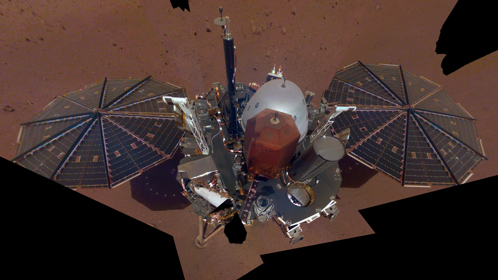
The selfie was taken on Dec. 6, 2018 (sol 10). Credit NASA/JPL-Caltech
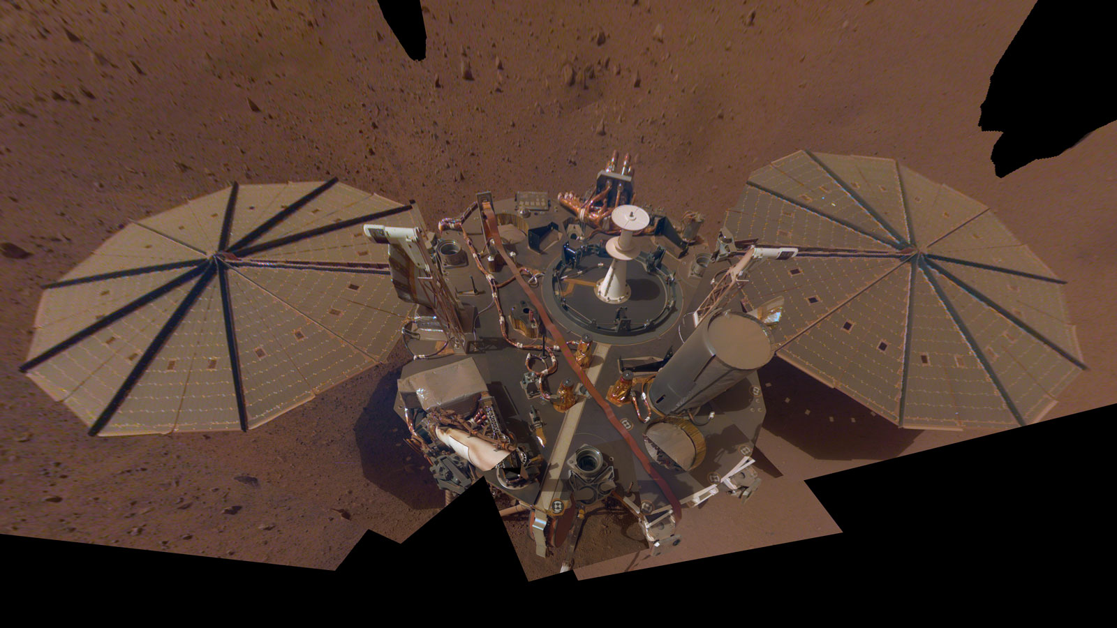
This selfie is a mosaic made up of 14 images taken on March 15 and April 11 — the 106th and 133rd Martian days, or sols, of the mission — by InSight's Instrument Deployment Camera, located on its robotic arm. Credit NASA/JPL-Caltech
The same winds that blanket Mars with dust can also blow that dust away. Catastrophic dust storms have the potential to end a mission, as with NASA's Opportunity rover. But far more often, passing winds cleared off the rover's solar panels and gave it an energy boost. Those dust clearings allowed Opportunity and its sister rover, Spirit, to survive for years beyond their 90-day expiration dates.
Dust clearings are also expected for Mars' newest inhabitant, the InSight lander. Because of the spacecraft's weather sensors, each clearing can provide crucial science data on these events, as well — and the mission already has a glimpse at that.
On Feb. 1, the 65th Martian day, or sol, of the mission, InSight detected a passing wind vortex (also known as a dust devil if it picks up dust and becomes visible; InSight's cameras didn't catch the vortex in this case). At the same time, the lander's two large solar panels experienced very small bumps in power — about 0.7% on one panel and 2.7% on the other — suggesting a tiny amount of dust was lifted.
Those are whispers compared to cleanings observed by the Spirit and Opportunity rovers, where dust-clearing wind gusts occasionally boosted power by as much as 10% and left solar panels visibly cleaner. But the recent event has given scientists their first measurements of wind and dust interacting "live" on the Martian surface; none of NASA's solar-powered rovers have included meteorological sensors that record so much round-the-clock data. In time, data from dust cleanings could inform the design of solar-powered missions as well as research on how wind sculpts the landscape.
"It didn't make a significant difference to our power output, but this first event is fascinating science," said InSight science team member Ralph Lorenz of Johns Hopkins University's Applied Physics Laboratory in Laurel, Maryland. "It gives us a starting point for understanding how the wind is driving changes on the surface. We still don't really know how much wind it takes to lift dust on Mars."
Engineers regularly calculate a "dust factor," a measure of how much dust is covering the panels, when analyzing InSight's solar power. While they saw no change in dust factor around the time of this passing dust devil, they saw a clear increase in electrical current, suggesting it did lift a little bit of dust.
Key to measuring these cleanings are InSight's weather sensors, collectively known as the Auxiliary Payload Sensor Suite, or APSS. During this first dust event, APSS saw a steady increase in wind speed and a sharp drop in air pressure — the signature of a passing dust devil.
The wind direction changed by about 180 degrees, which would be expected if a dust devil had passed directly over the lander. APSS measured a peak wind speed of 45 miles per hour (20 meters per second). But it also detected the biggest air pressure drop ever recorded by a Mars surface mission: 9 pascals, or 13% of ambient pressure. That pressure drop suggests there may have been even stronger winds that were too turbulent for sensors to record.
"The absolute fastest wind we've directly measured so far from InSight was 63 miles per hour (28 meters per second), so the vortex that lifted dust off our solar panels was among the strongest winds we've seen," said InSight participating scientist Aymeric Spiga of the Dynamic Meteorology Laboratory at Sorbonne University in Paris. "Without a passing vortex, the winds are more typically between about 4-20 miles per hour (2-10 meters per second), depending on time of day."
This dust lifting happened at 1:33 p.m. local Mars time, which is also consistent with the detection of a dust devil. On both Mars and Earth, the highest levels of dust devil activity are usually seen between about noon and 3 p.m., when the intensity of sunlight is strongest and the ground is hot compared with the air above it.
InSight landed on Nov. 26, 2018, in Elysium Planitia, a windy region on the Martian equator. The lander has already detected many passing dust devils, and Lorenz said it's likely the spacecraft will see a number of large dust cleanings over the course of its two-year prime mission.
Each of InSight's dinner-table-size solar panels has gathered a thin dust layer since landing. Their power output has fallen about 30% since then, due both to dust as well as Mars to moving farther from the Sun. Today the panels produce about 2,700 watt-hours per sol — plenty of energy for daily operations, which require roughly 1,500 watt-hours per sol.
The mission's power engineers are still waiting for the kind of dust cleaning Spirit and Opportunity experienced. But even if they don't see one for a while, they have ample power.
Bron: mars.nasa.gov
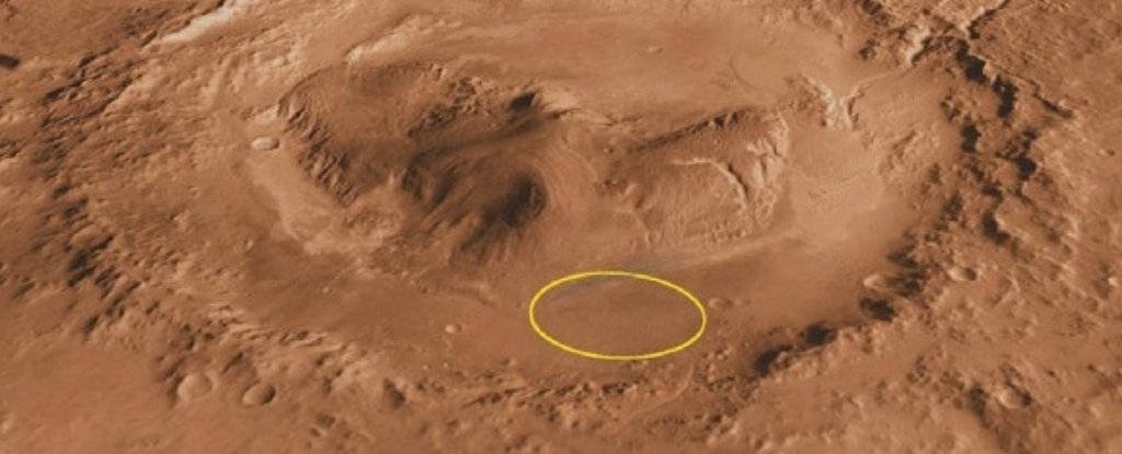
Curiosity heeft een grote ontdekking gedaan: Klei gevonden!
Klei betekent...water in de buurt (geweest)!Curiosity Has Made a Huge Discovery at Its Primary Mission Target on Mars
(NASA/JPL)
Curiosity Has Made a Huge Discovery at Its Primary Mission Target on MarsEVAN GOUGH, UNIVERSE TODAY
3 JUN 2019Clay is a big deal on Mars because it often forms in contact with water. Find clay, and you've usually found evidence of water. And the nature, history, and current water budget on Mars are all important to understanding that planet, and if it ever supported life.
Right now, MSL Curiosity is at Mt Sharp inspecting rocks for clay. Orbiters were the first to find evidence of clay at Mt Sharp. When NASA chose Gale Crater as MSL Curiosity's landing site, the clay at Mt Sharp inside the crater was one of the objectives.
Now Curiosity has sampled two of the rocks in what NASA's calling the 'clay-bearing unit' and they've confirmed the presence of clay.
In fact, the two rocks show the highest concentrations of clay that Curiosity has found so far. The rocks are called "Aberlady" and "Kilmarie." They're located at the lower part of Mt Sharp, which is the mission's primary objective.
Mt Sharp rises 5.5 km (18,000 ft) above the crater floor, meaning it is an accessible, layered record of Martian geology. Over time, wind has exposed its different layers, making them easy targets for Curiosity's drill.
Scientists are interested in Mt Sharp, also called Aeolis Mons, because of how they think it formed. Gale Crater is an ancient impact crater that was likely filled with water, and they think that Mt Sharp formed over a time period of two billion years, as sediment was deposited at the bottom of the lake.
It's possible that at one time the entire crater was filled with sediment, which gradually eroded, leaving Mt Sharp behind.
There's some uncertainty around the timeline of Mt Sharp's formation, which is one of the things MSL Curiosity hopes to uncover. In any case, Mt Sharp itself appears to be an eroded mountain of sediment, and as Curiosity continues its work, scientists may finally get a clearer picture of how exactly it formed.
Curiosity's new findings show that there was once an abundance of water in Gale Crater, as expected. But other than that, the details are still to be determined.
It seems that these clay-rich rocks at the lower range of the mountain formed as sediment at the bottom of a lake. Over geological time periods, water and sediment interact to form clays.
Finding specific types of clays at specific layers tells scientists about the timeline of Martian water. We know that the mountain has different layers containing different minerals.
As mentioned, the lower layers contain clays, but above that are layers containing sulfur, and above that are layers containing oxygen-bearing minerals. The sulfur indicates that the area dried out, or the water became more acidic.
Gale crater also contains a river channel called Gediz Vallis Channel, which formed after the clay and sulfur layers. That channel is also a piece of the puzzle, and Curiosity's task is to continue its way up Mt Sharp, sampling as it goes, and fill in the picture of the mountain's geology and history. By extension, we'll learn something about Martian history.
Curiosity will also give us a much more detailed view of the clay-bearing unit than orbiter's gave us. Orbital readings couldn't say for sure if the clay it sensed was in the bedrock of the mountain, or if it was from eroded pebbles and rocks that had eroded out of the upper layers of the mountain and tumbled down to the floor of the crater.
Curiosity has clarified that to some degree, with the discovery of clay in Aberlady and Kilmarlie, but there's still lots of work to do.
"Each layer of this mountain is a puzzle piece," said Curiosity Project Scientist Ashwin Vasavada of JPL. "They each hold clues to a different era in Martian history."
Curiosity is doing a fine job of piecing it all together.
Bron: sciencealert.com
| Gewijzigd: 3 juni 2019, 11:06 uur, door Lako
NASA vernoemt rollende steen op Mars naar Rolling Stones
NASA heeft een steen op Mars naar The Rolling Stones vernoemd om de band te eren. De steen draagt voortaan de naam The Rolling Stone Rock, meldt InSight donderdag.The Rolling Stones zijn aangenaam verrast door het nieuws. "Wat een fantastische manier om onze No Filter Tour mee te vieren", aldus zanger Mick Jagger tijdens de openingsavond van de tournee van The Rolling Stones in Pasadena. "Dit is een mijlpaal in onze lange, bewogen geschiedenis. NASA: heel erg bedankt!"
Het gaat niet om zomaar een steen. De steen, die iets groter is dan een golfbal, heeft eind november vorig jaar 1 meter gerold. Dit is de grootste afstand die NASA een steen op een andere planeet ooit heeft zien afleggen.
Acteur Robert Downey jr. maakte de vernoeming donderdag bekend. Backstage reageerde Downey jr. op de gebeurtenis. "Doorbraken in de wetenschap en een legendarische rockband zijn altijd een goede combinatie", vindt de acteur.
Bron: nu.nl
NASA's InSight 'Hears' Peculiar Sounds on Mars
Clouds drift over the dome-covered seismometer, known as SEIS, belonging to NASA's InSight lander, on Mars.
Credits: NASA/JPL-Caltech
Put an ear to the ground on Mars and you'll be rewarded with a symphony of sounds. Granted, you'll need superhuman hearing, but NASA's InSight lander comes equipped with a very special "ear."
The spacecraft's exquisitely sensitive seismometer, called the Seismic Experiment for Interior Structure (SEIS), can pick up vibrations as subtle as a breeze. The instrument was provided by the French space agency, Centre National d'Études Spatiales (CNES), and its partners.
SEIS was designed to listen for marsquakes. Scientists want to study how the seismic waves of these quakes move through the planet's interior, revealing the deep inner structure of Mars for the first time.
But after the seismometer was set down by InSight's robotic arm, Mars seemed shy. It didn't produce its first rumbling until this past April, and this first quake turned out to be an odd duck. It had a surprisingly high-frequency seismic signal compared to what the science team has heard since then. Out of more than 100 events detected to date, about 21 are strongly considered to be quakes. The remainder could be quakes as well, but the science team hasn't ruled out other causes.
Quakes
Put on headphones to listen to two of the more representative quakes SEIS has detected. These occurred on May 22, 2019 (the 173rd Martian day, or sol, of the mission) and July 25, 2019 (Sol 235). Far below the human range of hearing, these sonifications from SEIS had to be speeded up and slightly processed to be audible through headphones. Both were recorded by the "very broad band sensors" on SEIS, which are more sensitive at lower frequencies than its short period sensors.
The Sol 173 quake is about a magnitude 3.7; the Sol 235 quake is about a magnitude 3.3.
https://soundcloud.com/nasa/quake-sol-173
https://soundcloud.com/nasa/quake-sol-235
Each quake is a subtle rumble. The Sol 235 quake becomes particularly bass-heavy toward the end of the event. Both suggest that the Martian crust is like a mix of the Earth's crust and the Moon's. Cracks in Earth's crust seal over time as water fills them with new minerals. This enables sound waves to continue uninterrupted as they pass through old fractures. Drier crusts like the Moon's remain fractured after impacts, scattering sound waves for tens of minutes rather than allowing them to travel in a straight line. Mars, with its cratered surface, is slightly more Moon-like, with seismic waves ringing for a minute or so, whereas quakes on Earth can come and go in seconds.
Mechanical Sounds and Wind Gusts
SEIS has no trouble identifying quiet quakes, but its sensitive ear means scientists have lots of other noises to filter out. Over time, the team has learned to recognize the different sounds. And while some are trickier than others to spot, they all have made InSight's presence on Mars feel more real to those working with the spacecraft.
"It's been exciting, especially in the beginning, hearing the first vibrations from the lander," said Constantinos Charalambous, an InSight science team member at Imperial College London who works with the SP sensors. "You're imagining what's really happening on Mars as InSight sits on the open landscape."
Charalambous and Nobuaki Fuji of Institut de Physique du Globe de Paris provided the audio samples for this story, including the one below, which is also best heard with headphones and captures the array of sounds they're hearing.
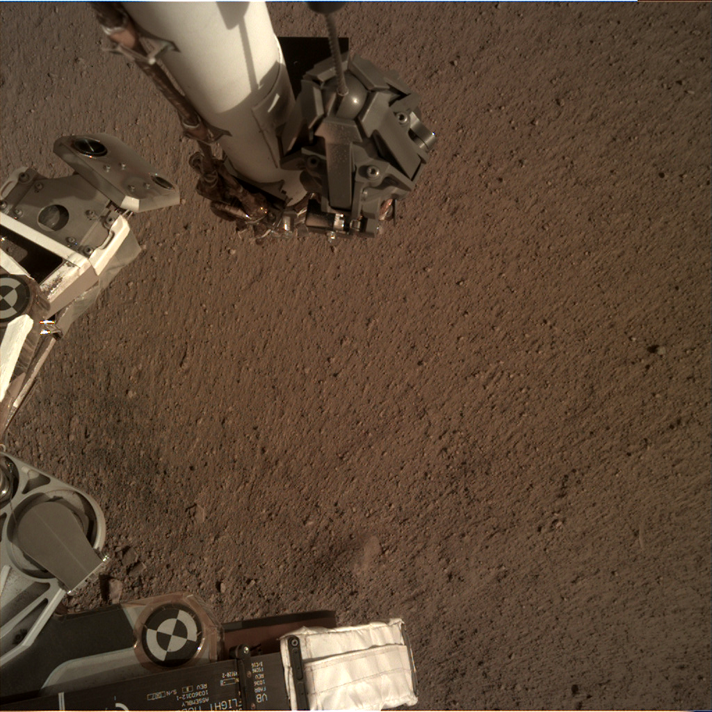
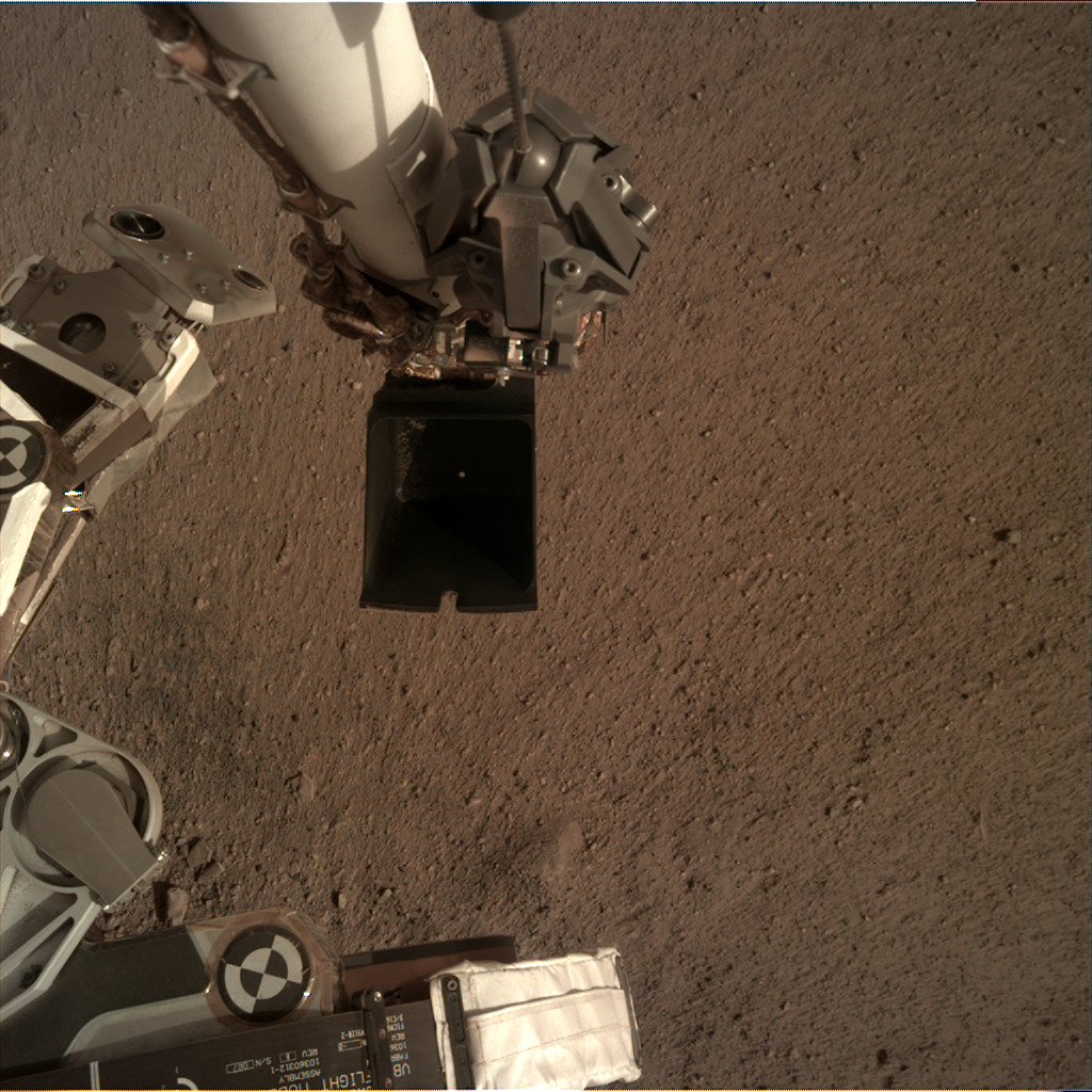
On March 6, 2019, a camera on InSight's robotic arm was scanning the surface in front of the lander. Each movement of the arm produces what to SEIS is a piercing noise.
Wind gusts can also create noise. The team is always on the hunt for quakes, but they've found the twilight hours are one of the best times to do so. During the day, sunlight warms the air and creates more wind interference than at night.
Evening is also when peculiar sounds that the InSight team has nicknamed "dinks and donks" become more prevalent. The team knows they're coming from delicate parts within the seismometer expanding and contracting against one another and thinks heat loss may be the factor, similar to how a car engine "ticks" after it's turned off and begins cooling.
You can hear a number of these dinks and donks in this next set of sounds, recorded just after sundown on July 16, 2019 (Sol 226). Listen carefully and you can also pick out an eerie whistling that the team thinks may be caused by interference in the seismometer's electronics.https://soundcloud.com/nasa/dinks-and-donks-sampleWhat does it sound like to you? A hall full of grandfather clocks? A Martian jazz ensemble? Share your thoughts with us on Twitter.
About InSight
JPL manages InSight for NASA's Science Mission Directorate. InSight is part of NASA's Discovery Program, managed by the agency's Marshall Space Flight Center in Huntsville, Alabama. Lockheed Martin Space in Denver built the InSight spacecraft, including its cruise stage and lander, and supports spacecraft operations for the mission.
A number of European partners, including France's Centre National d'Études Spatiales (CNES) and the German Aerospace Center (DLR), are supporting the InSight mission. CNES provided the Seismic Experiment for Interior Structure (SEIS) instrument to NASA, with the principal investigator at IPGP (Institut de Physique du Globe de Paris). Significant contributions for SEIS came from IPGP; the Max Planck Institute for Solar System Research (MPS) in Germany; the Swiss Federal Institute of Technology (ETH Zurich) in Switzerland; Imperial College London and Oxford University in the United Kingdom; and JPL. DLR provided the Heat Flow and Physical Properties Package (HP3) instrument, with significant contributions from the Space Research Center (CBK) of the Polish Academy of Sciences and Astronika in Poland. Spain's Centro de Astrobiología (CAB) supplied the temperature and wind sensors.
Bron: nasa.gov
Theorie weerlegd: aardverschuivingen op Mars kunnen ook op andere manieren dan door ijs ontstaan.
En dat is belangrijk aangezien geologische processen op Mars ons ook meer vertellen over diezelfde processen op aarde.Wie het oppervlak van Mars eens grondig bestudeert, komt al gauw tot een interessante conclusie. Het oppervlak is namelijk verre van glad en bestaat uit enorme pieken, dalen en lange richels. Sommige richels zijn daarnaast abnormaal hoog en lang. Hoe die zijn ontstaan? Daar is de wetenschap al wel over uit. Deze opvallende structuren zijn namelijk het gevolg van enorme aardverschuivingen waarbij vele duizenden tonnen aan grond plotseling in beweging komen en (meestal) langs een helling vallen of naar beneden glijden. Lang werd gedacht dat deze aardverschuivingen in gang worden gezet door een onderliggende laag glad ijs. Maar dat hoeft niet noodzakelijkerwijs zo te zijn, aldus onderzoekers. En die bevinding heeft ook belangrijke implicaties voor onze aarde.
Aardverschuiving
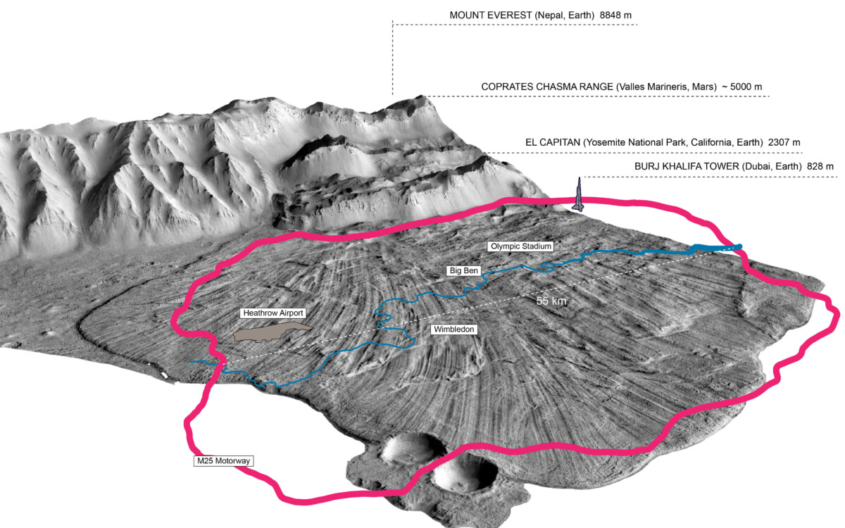
In de studie namen de onderzoekers de enorme kloof Coprates Chasma onder de loep die zich bevindt in het grote klovensysteem Valles Marineris. Het team gebruikte hiervoor afbeeldingen gemaakt met NASA’s Mars Reconnaissance Orbiter. “In het gebied bevinden zich lange richels die het oppervlak markeren van een Martiaanse aardverschuiving,” legt onderzoeker Giulia Magnarini aan Scientias.nl uit. Waarschijnlijk vond deze aardverschuiving zo’n 400 miljoen jaar geleden plaats waarna de enorme richels gevormd werden. “De richels strekken zich uit over ongeveer veertig kilometer; dat is bijna de hele lengte van de aardverschuiving.” In de studie hebben de onderzoekers gepoogd meer inzicht te krijgen in hoe deze enorme structuren worden gevormd. “Dat zal helpen om de achterliggende mechanismen te begrijpen die de mega-aardverschuivingen veroorzaken,” aldus Magnarini.
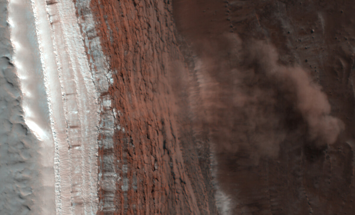
Een aardverschuiving op Mars op heterdaad betrapt. Afbeelding: NASA (via Wikimedia Commons)
Allereerst werd de vorm van de aardverschuiving bestudeerd. “De aardverschuiving heeft een mooie waaiervorm,” zegt Magnarini. “Terwijl de richels zich in dezelfde richting als de beweging van de aardverschuiving uitstrekken, bewegen ze vervolgens van elkaar weg. In de ruimte tussen deze richels in, worden er weer nieuwe richels gevormd.” De onderzoekers besloten de pieken van de richels te meten en kwamen tot de ontdekking dat de afstand altijd twee á drie keer de dikte van de aardverschuiving is. “Er is dus een constant verband tussen deze twee parameters,” concludeert Magnarini. “Waar de afzetting van de aardverschuiving het dikste is, zijn de richels zo’n zestig meter hoog en de groeven zo breed als acht Olympische zwembaden. Naarmate de afzetting dunner wordt liggen de richels dichter bij elkaar en zijn bovendien minder hoog, ongeveer tien meter.”
Afzettingen van een aardverschuiving gelegen in de Valles Marineris vergeleken met structuren op aarde. Afbeelding: Giulia Magnarini / NASA
IJs
Zoals gezegd werd lang gedacht dat deze aardverschuivingen werden veroorzaakt door onderliggend glad ijs. “Toen we in de jaren zestig de eerste beelden van het oppervlak van Mars verkregen en de enorme aardverschuivingen zichtbaar werden, constateerden onderzoekers dat er een overeenkomst bestond tussen de bergkammen van deze aardverschuivingen op Mars en die van aardverschuivingen bovenop gletsjers op aarde,” vertelt Magnarini. “Ze hebben namelijk soortgelijke ribbels en groeven. Dit ondersteunde het idee dat er voor het ontstaan van aardverschuivingen blijkbaar ijs nodig is.”
Droge laag
Maar dat blijkt nu toch niet helemaal te kloppen. De gemeten verhoudingen van de richels
blijken namelijk overeen te komen met experimenten die al eerder met zand zijn gedaan. “Tijdens deze experimenten zagen onderzoekers de vorming van lange strepen, zoals richels en groeven,” verduidelijkt Magnarini. “In deze experimenten werd er eveneens een verband gevonden tussen de afstand van de pieken en de dikte van de korrelige stroom (ongeveer twee á drie keer; dat zijn dezelfde verhoudingen die wij op het oppervlak van Mars terugzagen).” Dit suggereert dat een onstabiele en droge ondergrond die bestaat uit gefragmenteerde rotsen net zo goed aardverschuivingen in gang kan zetten. “De gefragmenteerde rotsen botsen met het ruwe oppervlak van de vallei en ook met elkaar,” legt Magnarini uit. Dit leidt ertoe dat enorme hoeveelheden grond met snelheden van wel 360 kilometer per uur op Mars naar beneden kwamen denderen. En op die manier zagen mogelijk de unieke structuren en bijzondere formaties op de rode planeet het levenslicht.“WE WETEN NU DAT IJS NIET PER DEFINITIE NODIG IS”Uitdagen
De onderzoekers hebben hiermee aangetoond dat er voor het ontstaan van aardverschuivingen niet per se glad ijs nodig is. Deze kunnen dus net zo goed op ruwe, rotsachtige oppervlakken in beweging worden gezet. Al betekent het niet dat hier helemaal geen ijs bij betrokken is. “We sluiten de aanwezigheid van ijs niet geheel uit,” zegt co-auteur Tom Mitchell. “Maar we weten nu dat ijs niet per definitie nodig is.” En dat is voor zeker twee verschillende redenen belangrijk om aan te tonen. “Als we de richels zouden gebruiken om de aanwezigheid van ijs uit aan te tonen – zoals vroeger dus werd gedacht – dan zouden we de oorsprong van het landschap verkeerd interpreteren,” legt Magnarini desgevraagd uit. “We zouden in dat geval geologische en klimatologische modellen van Mars maken die niet kloppen. De andere reden heeft te maken met de aarde. Om mega-aardverschuivingen beter te begrijpen, gebruiken we vaak Mars als schoolvoorbeeld voor de aarde. Op aarde is het namelijk niet gemakkelijk om vroegere aardverschuivingen te onderzoeken omdat sporen hiervan door middel van erosie, regen etc. verloren gaan. Op Mars blijven deze landvormen vanwege de zeer lage erosiesnelheid beter bewaard. Bovendien is hier geen vegetatie die aardverschuivingen bedekken. Dit alles stelt ons in staat om de mega-aardverschuivingen op de rode planeet te bestuderen op een manier die niet mogelijk is op aarde. Alles wat we vervolgens leren van Mars kunnen we gebruiken om ook de aardse aardverschuivingen beter te begrijpen. Dus als we denken dat deze mega-aardverschuivingen en hun structuren tot stand komen vanwege de aanwezigheid van ijs, dan kan dit leiden tot gevaarlijk verkeerde interpretaties. Hierdoor zouden we de mogelijke risico’s van deze aardverschuivingen voor bepaalde infrastructuren en zelfs mensenlevens in gebieden waar geen ijs is, over het hoofd zien.”
Wat dat betreft is het belangrijk om te weten welke factoren gepaard gaan met aardverschuivingen en waardoor ze precies worden veroorzaakt. “We weten dat er in het verleden op aarde enorme aardverschuivingen hebben plaatsgevonden en we weten zeker dat ze ook in de toekomst weer voor zullen komen,” zegt Magnarini. “Daarom is het belangrijk om risicogebieden aan te kunnen wijzen en bepaalde indicaties niet te negeren. En door andere planeten te bestuderen, kunnen we ook de geologische processen op onze eigen planeet beter begrijpen.”
Bron: scientias.nl