
Tropical depressions could form in Atlantic
Energy and commodities markets on Tuesday were watching a couple of low-pressure systems in the Atlantic Ocean that could develop into tropical depressions over the next day or so. Neither system, however, is expected to reach the Gulf of Mexico over the next five days, if at all, according to the major weather models.
Deze foto is niet meer beschikbaar
In the central Atlantic, a broad area of low pressure associated with a tropical wave about 650 miles east of the Lesser Antilles could develop into a tropical depression during the next day or so as it moves west-northwest at 10 to 15 miles per hour, the U.S. National Hurricane Center said in its 8 a.m. EDT report.
The NHC said an Air Force Reserve hurricane hunter aircraft was scheduled to investigate the central Atlantic system later today, if necessary. Most weather models showed the central Atlantic system would steer north of the Lesser Antilles and threaten the Turks and Caicos and Bahamas in about five days.
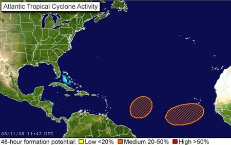
In the eastern Atlantic, the NHC said a tropical depression could form over the next day or so within a large area of disturbed weather extending from the Cape Verde Islands west-southwest for several hundred miles as it moves west at about 10 to 15 mph.
Most weather models showed the Cape Verde system would not threaten land in North America this week. It should be about 700 miles northeast of the Virgin Islands in about five days, according to the weather models. If either system strengthens into a tropical storm, with winds of 39 to 73 mph, the NHC will name it Fay.
Energy traders watch for storms that could enter the Gulf of Mexico and threaten U.S. oil and gas production facilities.
Klik hier voor het hele artikel
©Reuters
Energy and commodities markets on Tuesday were watching a couple of low-pressure systems in the Atlantic Ocean that could develop into tropical depressions over the next day or so. Neither system, however, is expected to reach the Gulf of Mexico over the next five days, if at all, according to the major weather models.
Deze foto is niet meer beschikbaar
In the central Atlantic, a broad area of low pressure associated with a tropical wave about 650 miles east of the Lesser Antilles could develop into a tropical depression during the next day or so as it moves west-northwest at 10 to 15 miles per hour, the U.S. National Hurricane Center said in its 8 a.m. EDT report.
The NHC said an Air Force Reserve hurricane hunter aircraft was scheduled to investigate the central Atlantic system later today, if necessary. Most weather models showed the central Atlantic system would steer north of the Lesser Antilles and threaten the Turks and Caicos and Bahamas in about five days.
In the eastern Atlantic, the NHC said a tropical depression could form over the next day or so within a large area of disturbed weather extending from the Cape Verde Islands west-southwest for several hundred miles as it moves west at about 10 to 15 mph.
Most weather models showed the Cape Verde system would not threaten land in North America this week. It should be about 700 miles northeast of the Virgin Islands in about five days, according to the weather models. If either system strengthens into a tropical storm, with winds of 39 to 73 mph, the NHC will name it Fay.
Energy traders watch for storms that could enter the Gulf of Mexico and threaten U.S. oil and gas production facilities.
Klik hier voor het hele artikel
©Reuters
Tropical depression less likely in Atlantic: NHC
NEW YORK (Reuters) - A tropical wave heading toward the Greater Antilles and the Bahamas became less organized overnight and the U.S. National Hurricane Center canceled an aircraft scheduled to investigate the system, the NHC said in its 8 a.m. EDT (1200 GMT) report.
Energy and commodities markets have been watching the Greater Antilles/Bahamas system and another system in the eastern Atlantic for about three days. The Greater Antilles/Bahamas system was more interesting to the market since it had more potential to reach the oil rich Gulf of Mexico sometime next week.
The NHC said environmental conditions in the Greater Antilles/Bahamas system, which is about 300 miles east of the Lesser Antilles (the Caribbean islands from the Virgin Islands south to Trinidad), are "only marginally favorable for development and the potential for tropical cyclone formation during the next day or two has decreased."
On Monday and Tuesday, the NHC had said the Greater Antilles/Bahamas system could develop into a tropical depression over the next day or so as it moves west-northwest at 10 to 15 miles per hour.
Most weather models showed the Greater Antilles/Bahamas system would steer north of the Lesser Antilles and reach the area around the northern Greater Antilles (Cuba, Hispaniola and Puerto Rico) and the Bahamas over the next five days.
Elsewhere in the Atlantic, the NHC said some development of the low pressure system about 700 miles west of the Cape Verde Islands remained possible during the next couple of days as it moves west at 10 to 15 mph.
But since most weather models showed the Cape Verde system would likely not threaten the Gulf of Mexico or any land in North America, the energy market is not very interested in this system at this time.
The models show the Cape Verde system will cross the 30th parallel north of the equator about 1,000 miles east of Bermuda and turn back east over the next five days. Once a weather system climbs north of the 30th parallel, energy traders say it will not threaten the Gulf of Mexico since most of the Gulf is south of the 30th parallel.
If either system strengthens into a tropical storm, with winds of 39 to 73 mph, the NHC will name it Fay.
Bron:Reuters

Tropical depression may form near Puerto Rico
NEW YORK (Reuters) - A low pressure system associated with a tropical wave is passing over the northern Leeward Islands and could become a tropical depression Thursday or Friday but probably won't threaten the oil rich Gulf of Mexico, the U.S. National Hurricane Center said in its 8 a.m. EDT (1200 GMT) report.
Weather models show the system will pass to the north side of Puerto Rico and Hispaniola before turning north and crossing the Bahamas over the next five days without reaching the Florida coast.
An Air Force Reserve Reconnaissance aircraft is scheduled to investigate the system later Thursday, if necessary.
Regardless of development, the NHC warned the system could bring heavy rains and gusty winds to the northern Leeward Islands, Puerto Rico and Hispaniola during the next day or two.
The Leeward Islands include the Virgin Islands, Anguilla, Saint Martin, Saint Kitts, Nevis, Barbuda, Antigua, Montserrat and Guadeloupe.
Energy and commodities markets have been watching the Leeward system and another system in the Atlantic since August 11.
The Leeward system is more interesting to the market since earlier in the week it looked like it might reach the Gulf of Mexico sometime next week. That seems less likely now since the weather models do not expect it to reach the Florida coast.
If the system strengthens into a tropical storm, with winds of 39 to 73 mph, the NHC will name it Fay.
Energy traders watch for storms that could enter the Gulf of Mexico and threaten U.S. oil and gas production facilities.
bron: reuters | Gewijzigd: 14 augustus 2008, 20:27 uur, door Bronk
Tropical Storm Fay headed toward Haiti
Tropical Storm Fay was expected to move across Haiti on Saturday, the National Hurricane Center said. The storm, the sixth of the Atlantic 2008 season, had maximum sustained winds near 45 mph with higher gusts, forecasters said.

The storm formed Friday over the Dominican Republic in the Caribbean Sea. As of 2 a.m. ET Saturday, the center of Fay was about 60 miles east of Port Au Prince, Haiti, and about 260 miles east-southeast of Guantanamo, Cuba.
It was moving west at about 14 mph and was expected to continue moving west-northwest over the next day, forecasters said. Fay is expected to dump 4 to 8 inches of rain over Hispaniola and eastern Cuba, with possible isolated amounts up to 12 inches, the hurricane center said. Heavy rain could trigger floods and mudslides and raise tides 1 to 2 feet above normal levels in the warning area.
A tropical storm warning is now in effect for the entire coast of Haiti, the hurricane center said. A tropical storm warning was also issued for the northern coast of the Dominican Republic and for the southern coast east of San Pedro de Macoris, forecasters said. The government of Cuba issued a warning for Guantanamo, Santiago de Cuba and Granma provinces.
A tropical storm warning means tropical storm conditions are expected in the warning area within the next 24 hours. A tropical storm watch was issued for the Cuban provinces of Holguin and Las Tunas, the hurricane center said. A watch means tropical storm conditions are possible within 36 hours.
Long-range forecasts show the storm reaching the Florida Keys late Monday before heading into the southeastern United States. However, because of the erratic nature of hurricane movement, long-range forecasts often vary from the eventual track.
©CNN | Gewijzigd: 16 augustus 2008, 10:55 uur, door Marga
Tropical Storm Fay was expected to move across Haiti on Saturday, the National Hurricane Center said. The storm, the sixth of the Atlantic 2008 season, had maximum sustained winds near 45 mph with higher gusts, forecasters said.
The storm formed Friday over the Dominican Republic in the Caribbean Sea. As of 2 a.m. ET Saturday, the center of Fay was about 60 miles east of Port Au Prince, Haiti, and about 260 miles east-southeast of Guantanamo, Cuba.
It was moving west at about 14 mph and was expected to continue moving west-northwest over the next day, forecasters said. Fay is expected to dump 4 to 8 inches of rain over Hispaniola and eastern Cuba, with possible isolated amounts up to 12 inches, the hurricane center said. Heavy rain could trigger floods and mudslides and raise tides 1 to 2 feet above normal levels in the warning area.
A tropical storm warning is now in effect for the entire coast of Haiti, the hurricane center said. A tropical storm warning was also issued for the northern coast of the Dominican Republic and for the southern coast east of San Pedro de Macoris, forecasters said. The government of Cuba issued a warning for Guantanamo, Santiago de Cuba and Granma provinces.
A tropical storm warning means tropical storm conditions are expected in the warning area within the next 24 hours. A tropical storm watch was issued for the Cuban provinces of Holguin and Las Tunas, the hurricane center said. A watch means tropical storm conditions are possible within 36 hours.
Long-range forecasts show the storm reaching the Florida Keys late Monday before heading into the southeastern United States. However, because of the erratic nature of hurricane movement, long-range forecasts often vary from the eventual track.
©CNN | Gewijzigd: 16 augustus 2008, 10:55 uur, door Marga
Tropical Storm Fay Crosses Hispaniola
Six Atlantic Storm This Season Hits Haiti, Heads Towards Cuba

(AP) Tropical Storm Fay is dumping heavy rain over Haiti and the Dominican Republic as it makes its way toward Cuba.
A tropical storm warning has been issued for the coast of Haiti and parts of Cuba, the Bahamas, and the Turks and Caicos Islands. The government of the Dominican Republican canceled its storm warnings.
The National Hurricane Center in Miami said at 8 a.m. EDT that the storm was centered about 170 miles east-southeast of Guantanamo, Cuba. It is heading toward the west at about 14 mph, with maximum sustained winds of 45 mph.
Forecasters say Fay may weaken slightly but could regain strength as it travels over warm water.
It is the sixth storm to form in the Atlantic this season.
Bron:CBS News
Six Atlantic Storm This Season Hits Haiti, Heads Towards Cuba
(AP) Tropical Storm Fay is dumping heavy rain over Haiti and the Dominican Republic as it makes its way toward Cuba.
A tropical storm warning has been issued for the coast of Haiti and parts of Cuba, the Bahamas, and the Turks and Caicos Islands. The government of the Dominican Republican canceled its storm warnings.
The National Hurricane Center in Miami said at 8 a.m. EDT that the storm was centered about 170 miles east-southeast of Guantanamo, Cuba. It is heading toward the west at about 14 mph, with maximum sustained winds of 45 mph.
Forecasters say Fay may weaken slightly but could regain strength as it travels over warm water.
It is the sixth storm to form in the Atlantic this season.
Bron:CBS News
Woman Killed, Children Missing in Dominican Republic as Tropical Storm Fay Aims for Cuba
SANTO DOMINGO, Dominican Republic — Flooding from Tropical Storm Fay killed one woman and left two children missing in the Dominican Republic, authorities said Saturday as it spun toward Cuba.
Forecasters said Fay could reach hurricane strength when it approaches central Cuba on Sunday, and the government there issued a hurricane watch for several provinces.
Fay also could turn toward the Florida Keys, the U.S. National Hurricane Center said.

The center reported that as of 11 a.m. EDT, the storm's center had passed over Haiti and was about 130 miles southeast of Guantanamo, Cuba. It was heading west at about 15 mph, with maximum sustained winds of 45 mph.
A 34-year-old woman drowned in the Dominican Republic when a family tried to cross a swollen river in a car, civil defense agency director Luis Luna Paulino said. Her 13-year-old girl and 5-year-old boy were missing, but her husband swam to safety.
Fay dumped heavy rain over Haiti late Friday, and the capital's airport remained closed Saturday although skies there had cleared. No deaths or injuries were reported.
A tropical storm warning was in effect for the coast of Haiti and parts of the Bahamas and the Turks and Caicos Islands. The government of the Dominican Republic canceled its storm warnings.
Fay is the sixth named storm to form in the Atlantic this season.
Bron:FOXNews
SANTO DOMINGO, Dominican Republic — Flooding from Tropical Storm Fay killed one woman and left two children missing in the Dominican Republic, authorities said Saturday as it spun toward Cuba.
Forecasters said Fay could reach hurricane strength when it approaches central Cuba on Sunday, and the government there issued a hurricane watch for several provinces.
Fay also could turn toward the Florida Keys, the U.S. National Hurricane Center said.
The center reported that as of 11 a.m. EDT, the storm's center had passed over Haiti and was about 130 miles southeast of Guantanamo, Cuba. It was heading west at about 15 mph, with maximum sustained winds of 45 mph.
A 34-year-old woman drowned in the Dominican Republic when a family tried to cross a swollen river in a car, civil defense agency director Luis Luna Paulino said. Her 13-year-old girl and 5-year-old boy were missing, but her husband swam to safety.
Fay dumped heavy rain over Haiti late Friday, and the capital's airport remained closed Saturday although skies there had cleared. No deaths or injuries were reported.
A tropical storm warning was in effect for the coast of Haiti and parts of the Bahamas and the Turks and Caicos Islands. The government of the Dominican Republic canceled its storm warnings.
Fay is the sixth named storm to form in the Atlantic this season.
Bron:FOXNews
Tropische storm Fay eist twee doden in Caraïben

De tropische storm Fay heeft in Haïti en de Dominicaanse Republiek minstens twee dodelijke slachtoffers gemaakt. Vier mensen zijn vermist, zo melden de hulpdiensten. De storm is nu onderweg naar Jamaica, Cuba, de Bahama's en Florida en kan uitgroeien tot een orkaan. Volgens een plaatselijke woordvoerder van de civiele bescherming viel in Haïti een dode in de stad Fond-Vérettes. "In het zuiden van het land raakte een persoon vermist. De inwoners van risicozones worden geëvacueerd", aldus de woordvoerder.
Waakzaam
Het meteorologische centrum van Haïti heeft een weersverbetering gemeld, maar het zeeverkeer op het hele eiland Hispaniola blijft verboden en de bevolking is gemaand waakzaam te blijven, omdat de zware regenval tot overstromingen en grondverschuivingen kan leiden. In de Dominicaanse Republiek is een 34-jarige vrouw verdronken toen een rivier in het plaatsje Higuey (op 140 km ten oosten van Santo Domingo) buiten haar oevers trad. Minstens drie mensen zijn vermist. Meer dan 200 inwoners van de regio hebben hun toevlucht in een gemeenschapscentrum moeten zoeken omdat hun woningen waren overstroomd, zo meldt gouverneur Pedro Rojas Morillo.
Orkaan
"In de komende dagen wordt verwacht dat de storm zal verslechteren", meldt het Amerikaanse National Hurricane Center. "Fay kan de kracht van een orkaan bereiken wanneer ze zondag Cuba nadert", zo luidt het. Fay is begonnen de Dominicaanse Republiek te verlaten, maar het grootste deel van het land blijft in staat van alarm wegens de kans op zware regenval en rukwinden. Het orkaanseizoen in het Atlantische gebied duurt van 1 juni tot 30 november. In een normaal seizoen komen 11 stormen voor, waarvan 6 orkanen. Maar voor 2008 worden 17 stormen verwacht, waarvan 9 orkanen.
Bron: HLN | Gewijzigd: 1 februari 2017, 15:18 uur, door Joyce.s
Every cloud has a silver lining
'Warmbloedige' Fay
Gisteren scheerde Fay over de Dominicaanse Republiek en Haiti. Gevolg: minimaal 5 doden, grote verwoesting en ongeveer 12.000 mensen zonder dak boven hun hoofd. Wat een kracht heeft zo'n storm! En dat allemaal met als grondstof: het warme zeewater. Een gewoon lagedrukgebied haalt zijn energie ergens anders vandaan.
Cuba krijgt Fay over zich heen
Vanochtend vroeg kreeg het zuidoosten van Cuba te maken met Fay. Rondom Guantanamo werd 38 knopen gemeten als doorstaande wind (is windkracht 8, stormachtig), en de windstoten gingen tot 45 knopen, oftewel 85 km per uur. Momenteel glijdt Fay langs de zuidwestkust van Cuba en verwacht wordt dat deze om 16.00 uur vanmiddag, onze tijd, weer de Cubaanse kust optrekt en dan inmiddels windkracht 9, storm, heeft bereikt. Boven Cuba zal iets van de kracht verloren gaan, maar eenmaal opnieuw boven de Golf zwelt de storm verder aan. Verwacht wordt dat maandagochtend om 04.00 uur (onze tijd) windkracht 10, zware storm, wordt bereikt en dat tijdens de nacht naar dinsdag, als Fay op de westkust van Florida arriveert, deze in sterkte is toegenomen tot orkaankracht. De nu verwachte windsnelheden voor dat moment bedragen 70 knopen.
De verwachte trekrichting en ontwikkeling van Fay. Dinsdagavond onze tijd nadert deze het westen van Florida. En dat wordt waarschijnlijk met orkaankracht. Bron: NOAA.
Waar haalt ‘ie zijn kracht vandaan?
Een orkaan, en wat daaraan voorafgaat: tropische storm, is een lagedrukgebied zonder fronten. Opvallend is dat de kracht vanaf ‘onderen’ komt. Oftewel van de oceaan. Dit soort tropische systemen ontwikkelt zich dankzij warm zeewater, veelal boven 27 graden. De motor van de orkaan zit dus onderin. De motor van een lagedrukgebied bevindt zich juist bovenin de atmosfeer: namelijk koude lucht.
Gevuld met kou
In afbeelding 3 en 4 hieronder, zien we respectievelijk de temperaturen op 500 hPa bij Fay en bij het lagedrukgebied dat zich momenteel ten westen van Ierland bevindt. 500 hPa ligt bij het lagedrukgebied op zo’n 5500 meter hoogte. Bij Fay ligt dat punt nog iets hoger. We zien dat het lagedrukgebied op de Atlantische Oceaan in de hogere luchtlagen gevuld is met extra kou. De temperatuur die daar in de kern wordt gegeven bedraagt rond -18 graden. In de omgeving van het lagedrukgebied is het al snel 6 graden minder koud. De ‘trek’ komt bij het lagedrukgebied dus van boven. Dat moet ook wel, de oceaan is hier een stuk kouder dan in de Golf van Mexico.

Afbeelding 3. Huidige temperaturen op 500 hPa in het Caribisch gebied. Je kunt de positie van Fay eruit halen, namelijk boven het zuidoosten van Cuba. Voor meer uitleg; zie tekst.

Afbeelding 4.Temperaturen op 500 hPa op de Atlantische Oceaan. Je kunt er een lagedrukgebied uit halen, zie tekst.
Gevuld met warmte
Terug naar Fay. Op afbeelding 3 zien we dat de temperaturen op 5 a 6 kilometer hoogte uiteraard een stuk hoger liggen dan boven de Atlantische Oceaan. De warmte van de Cariben werkt ook hogerop in de atmosfeer door. Toch kunnen we de kern van de orkaan vinden. Boven het zuidoosten van Cuba is het namelijk een fractie warmer dan in de omringende gebieden. Op 500 hPa is het daar rond -4 graden, tegen -6 elders. Een tropische storm is namelijk een zone waarin warme lucht omhoog wordt gezogen. De motor is het warme zeewater. De kracht wordt dus van onderaf gehaald. Warme vochtige lucht gaat in ziedende vaart opwaarts. Condenserende waterdamp veroorzaakt extra warmte en zo wordt een storm geleidelijk ook hogerop in de atmosfeer zichtbaar.
Fay is 'maar' een storm
Bij een goed ontwikkelde orkaan is dit proces nog veel beter zichtbaar dan nu bij de tropische storm. Fay is nog niet volledig tot stand gekomen en bovendien, in haar gang over de bergen van de Dominicaanse Republiek, deels uit elkaar geslagen. Bij hevige orkanen kan het verschil in temperatuur op 5 a 6 kilometer hoogte, wel groter zijn dan 5 tot 10 graden in vergelijking met de omgeving.
Bronnen: Meteo Consult, NOAA
Gisteren scheerde Fay over de Dominicaanse Republiek en Haiti. Gevolg: minimaal 5 doden, grote verwoesting en ongeveer 12.000 mensen zonder dak boven hun hoofd. Wat een kracht heeft zo'n storm! En dat allemaal met als grondstof: het warme zeewater. Een gewoon lagedrukgebied haalt zijn energie ergens anders vandaan.
Cuba krijgt Fay over zich heen
Vanochtend vroeg kreeg het zuidoosten van Cuba te maken met Fay. Rondom Guantanamo werd 38 knopen gemeten als doorstaande wind (is windkracht 8, stormachtig), en de windstoten gingen tot 45 knopen, oftewel 85 km per uur. Momenteel glijdt Fay langs de zuidwestkust van Cuba en verwacht wordt dat deze om 16.00 uur vanmiddag, onze tijd, weer de Cubaanse kust optrekt en dan inmiddels windkracht 9, storm, heeft bereikt. Boven Cuba zal iets van de kracht verloren gaan, maar eenmaal opnieuw boven de Golf zwelt de storm verder aan. Verwacht wordt dat maandagochtend om 04.00 uur (onze tijd) windkracht 10, zware storm, wordt bereikt en dat tijdens de nacht naar dinsdag, als Fay op de westkust van Florida arriveert, deze in sterkte is toegenomen tot orkaankracht. De nu verwachte windsnelheden voor dat moment bedragen 70 knopen.
De verwachte trekrichting en ontwikkeling van Fay. Dinsdagavond onze tijd nadert deze het westen van Florida. En dat wordt waarschijnlijk met orkaankracht. Bron: NOAA.
Waar haalt ‘ie zijn kracht vandaan?
Een orkaan, en wat daaraan voorafgaat: tropische storm, is een lagedrukgebied zonder fronten. Opvallend is dat de kracht vanaf ‘onderen’ komt. Oftewel van de oceaan. Dit soort tropische systemen ontwikkelt zich dankzij warm zeewater, veelal boven 27 graden. De motor van de orkaan zit dus onderin. De motor van een lagedrukgebied bevindt zich juist bovenin de atmosfeer: namelijk koude lucht.
Gevuld met kou
In afbeelding 3 en 4 hieronder, zien we respectievelijk de temperaturen op 500 hPa bij Fay en bij het lagedrukgebied dat zich momenteel ten westen van Ierland bevindt. 500 hPa ligt bij het lagedrukgebied op zo’n 5500 meter hoogte. Bij Fay ligt dat punt nog iets hoger. We zien dat het lagedrukgebied op de Atlantische Oceaan in de hogere luchtlagen gevuld is met extra kou. De temperatuur die daar in de kern wordt gegeven bedraagt rond -18 graden. In de omgeving van het lagedrukgebied is het al snel 6 graden minder koud. De ‘trek’ komt bij het lagedrukgebied dus van boven. Dat moet ook wel, de oceaan is hier een stuk kouder dan in de Golf van Mexico.
Afbeelding 3. Huidige temperaturen op 500 hPa in het Caribisch gebied. Je kunt de positie van Fay eruit halen, namelijk boven het zuidoosten van Cuba. Voor meer uitleg; zie tekst.
Afbeelding 4.Temperaturen op 500 hPa op de Atlantische Oceaan. Je kunt er een lagedrukgebied uit halen, zie tekst.
Gevuld met warmte
Terug naar Fay. Op afbeelding 3 zien we dat de temperaturen op 5 a 6 kilometer hoogte uiteraard een stuk hoger liggen dan boven de Atlantische Oceaan. De warmte van de Cariben werkt ook hogerop in de atmosfeer door. Toch kunnen we de kern van de orkaan vinden. Boven het zuidoosten van Cuba is het namelijk een fractie warmer dan in de omringende gebieden. Op 500 hPa is het daar rond -4 graden, tegen -6 elders. Een tropische storm is namelijk een zone waarin warme lucht omhoog wordt gezogen. De motor is het warme zeewater. De kracht wordt dus van onderaf gehaald. Warme vochtige lucht gaat in ziedende vaart opwaarts. Condenserende waterdamp veroorzaakt extra warmte en zo wordt een storm geleidelijk ook hogerop in de atmosfeer zichtbaar.
Fay is 'maar' een storm
Bij een goed ontwikkelde orkaan is dit proces nog veel beter zichtbaar dan nu bij de tropische storm. Fay is nog niet volledig tot stand gekomen en bovendien, in haar gang over de bergen van de Dominicaanse Republiek, deels uit elkaar geslagen. Bij hevige orkanen kan het verschil in temperatuur op 5 a 6 kilometer hoogte, wel groter zijn dan 5 tot 10 graden in vergelijking met de omgeving.
Bronnen: Meteo Consult, NOAA
Florida declares state of emergency as storm approaches
Tropical storm Fay is bearing down on Cuba after leaving five dead and one missing in the Dominican Republic and Haiti. Florida has declared an emergency and ordered tourists to leave the popular southern Keys.
The Miami-based United States National Hurricane Centre warned on Sunday that Fay, already packing winds of up to 85 kilometres an hour, could evolve into a hurricane in the coming hours and dump several inches of rain over Cuba, Jamaica and the Cayman Islands before lashing Florida on Monday (local time). It forecast Fay could soon be packing hurricane-strength winds of 120 kilometres an hour and placed a hurricane warning on parts of Cuba, islands off the southern tip of Florida and halfway up Florida's west coast. "Fay could be approaching hurricane strength when it reaches western Cuban tonight and when it approaches the Florida Keys Monday," the advisory said.
Authorities in the popular tourist spot of the Florida Keys archipelago, which comprises hundreds of islands, have ordered all visitors to evacuate and told residents to secure their homes and property, including boats. Residents in mobile homes and those living on boats were also told to evacuate. The main highway linking the Keys to the mainland was choked with traffic as visitors rushed to leave, Monroe County Sheriff's office spokeswoman Becky Herrin said. "There's no order for residents to evacuate the area, we have to wait and see the situation before taking more measures," she added. Florida Governor Charlie Crist declared a state of emergency in the area.
In mainland Miami meanwhile, residents began descending on gas stations and supermarkets to fill up gas tanks and stock up on bottled water and food supplies.
Bron:ABC news | Gewijzigd: 18 augustus 2008, 08:26 uur, door Marga
Visitors Urged to Leave Florida Keys Ahead of Fay
Tropical Storm Fay could hit Florida Keys as a hurricane, officials urge visitors to leave

Florida Keys officials closed schools, opened shelters and urged visitors to leave as Tropical Storm Fay threatened to strengthen into a hurricane Sunday, but residents and some tourists seemed in no hurry to evacuate.
Traffic leaving Key West and the Lower Keys on Sunday afternoon was light but steady as the sky darkened with storm clouds and the National Weather Service issued watches and warnings. More....
Bron: ABC
Tropical Storm Fay could hit Florida Keys as a hurricane, officials urge visitors to leave
Florida Keys officials closed schools, opened shelters and urged visitors to leave as Tropical Storm Fay threatened to strengthen into a hurricane Sunday, but residents and some tourists seemed in no hurry to evacuate.
Traffic leaving Key West and the Lower Keys on Sunday afternoon was light but steady as the sky darkened with storm clouds and the National Weather Service issued watches and warnings. More....
Bron: ABC
Every cloud has a silver lining
Olieprijs stijgt door bezorgdheid over storm Fay
De prijs van een vat ruwe olie is vandaag licht gestegen door de bezorgdheid van handelaars over de tropische storm Fay die het Amerikaanse continent treft.
De prijs voor een vat ruwe olie, met levering in september, steeg met 1,4 procent in New York, tot 115,35 dollar. In Londen ging de prijs voor een vat Brent-olie eveneens met 1,4 procent de hoogte in tot 114,13 dollar.
©Hln | Gewijzigd: 1 februari 2017, 15:18 uur, door Joyce.s
Oil price rises on U.S. hurricane fears
SINGAPORE (AP) -- Oil prices rose Monday in Asia on concerns that Tropical Storm Fay may disrupt oil operations in the Gulf of Mexico.

Fears about the impact of Tropical Storm Fay on the Gulf of Mexico's oil production has sent prices higher.
Light, sweet crude for September delivery rose 56 cents to $114.33 a barrel in electronic trading on the New York Mercantile Exchange by midafternoon in Singapore. The contract fell $1.24 on Friday to settle at $113.77 a barrel.
"There could be some supply disruption issues there so the market is watching this closely," said Mark Pervan, senior commodity strategist at ANZ Bank in Melbourne.
Fay, the sixth storm of the 2008 Atlantic season, was slowing down early Monday and moving erratically, but forecasters still expected it to strengthen slowly to a hurricane. Fay has already killed at least five people after battering Haiti and the Dominican Republic with weekend torrential rains and floods.
Oil giant Royal Dutch Shell has evacuated about 360 staff from the Gulf of Mexico over the past two days.
Early Monday, Fay was centered about 275 kilometers (170 miles) southeast of Havana and 375 kilometers (235 miles) south-southeast of Key West, Florida, according to the U.S. National Hurricane Center in Miami.
It had maximum sustained winds near 85 kph (50 mph) and was moving west-northwest at 17 kph (10 mph).
Forecasters expected the storm to begin moving more to the northwest later on Monday. Current models show the storm moving up the western coast of Florida, although forecasters still didn't know exactly where it would make landfall.
So far during this year's hurricane season in the Atlantic Ocean, no storm has significantly damaged oil installations in the Gulf.
"The market will probably get through this hurricane news pretty quickly," Pervan said.
A weaker dollar also supported oil prices. The euro strengthened to $1.4732 on Monday and the dollar was steady above 110 yen.
A falling dollar typically pushes oil prices higher as investors buy crude and other commodities as hedges against inflation.
A forecast from the Organization of Petroleum Exporting Countries on Friday of lower global oil demand growth helped to keep prices from rising higher.
In its monthly oil report, the organization forecast world appetite for oil this year would grow by 1 million barrels a day, a reduction of 30,000 barrels a day from its previous forecast for demand growth for 2008. It also said growth for 2009 will be 900,000 barrels a day, which it said would be the lowest growth in world demand since 2002.
Demand growth from the major industrialized countries will actually decline, OPEC said, with non-OECD countries accounting for all oil demand growth next year.
"It's another signal that conditions are easing," Pervan said
Bron:CNN.com | Gewijzigd: 18 augustus 2008, 13:28 uur, door Kikimero
SINGAPORE (AP) -- Oil prices rose Monday in Asia on concerns that Tropical Storm Fay may disrupt oil operations in the Gulf of Mexico.
Fears about the impact of Tropical Storm Fay on the Gulf of Mexico's oil production has sent prices higher.
Light, sweet crude for September delivery rose 56 cents to $114.33 a barrel in electronic trading on the New York Mercantile Exchange by midafternoon in Singapore. The contract fell $1.24 on Friday to settle at $113.77 a barrel.
"There could be some supply disruption issues there so the market is watching this closely," said Mark Pervan, senior commodity strategist at ANZ Bank in Melbourne.
Fay, the sixth storm of the 2008 Atlantic season, was slowing down early Monday and moving erratically, but forecasters still expected it to strengthen slowly to a hurricane. Fay has already killed at least five people after battering Haiti and the Dominican Republic with weekend torrential rains and floods.
Oil giant Royal Dutch Shell has evacuated about 360 staff from the Gulf of Mexico over the past two days.
Early Monday, Fay was centered about 275 kilometers (170 miles) southeast of Havana and 375 kilometers (235 miles) south-southeast of Key West, Florida, according to the U.S. National Hurricane Center in Miami.
It had maximum sustained winds near 85 kph (50 mph) and was moving west-northwest at 17 kph (10 mph).
Forecasters expected the storm to begin moving more to the northwest later on Monday. Current models show the storm moving up the western coast of Florida, although forecasters still didn't know exactly where it would make landfall.
So far during this year's hurricane season in the Atlantic Ocean, no storm has significantly damaged oil installations in the Gulf.
"The market will probably get through this hurricane news pretty quickly," Pervan said.
A weaker dollar also supported oil prices. The euro strengthened to $1.4732 on Monday and the dollar was steady above 110 yen.
A falling dollar typically pushes oil prices higher as investors buy crude and other commodities as hedges against inflation.
A forecast from the Organization of Petroleum Exporting Countries on Friday of lower global oil demand growth helped to keep prices from rising higher.
In its monthly oil report, the organization forecast world appetite for oil this year would grow by 1 million barrels a day, a reduction of 30,000 barrels a day from its previous forecast for demand growth for 2008. It also said growth for 2009 will be 900,000 barrels a day, which it said would be the lowest growth in world demand since 2002.
Demand growth from the major industrialized countries will actually decline, OPEC said, with non-OECD countries accounting for all oil demand growth next year.
"It's another signal that conditions are easing," Pervan said
Bron:CNN.com | Gewijzigd: 18 augustus 2008, 13:28 uur, door Kikimero
Fay Hits Cuba, Sets Sights On Florida
(CBS/AP) Tropical Storm Fay pounded Cuba with torrential rain and wind Monday, prompting authorities to evacuate dozens of low-lying communities, cancel carnival celebrations in a central of province and warn of flooding.
Forecasters said Fay, which earlier left at least five people dead in Haiti and the Dominican Republic, crossed central Cuba early Monday and was expected to pass near the Florida Keys that night.

A satellite image provided by the National Oceanic and Atmospheric Administration shows Tropical Storm Fay over Cuba at 2: 45 a.m. EDT Monday Aug. 18, 2008.
A hurricane watch remained in effect for the capital, Havana, and eastward to Cuba's central Sancti Spiritus province.
A tropical storm watch was issued Monday for the northwestern Bahamas.
Cuban state media reported little damage or major flooding so far, but authorities in four provinces evacuated nearly 5,000 residents from low-lying communities and pulled fishing boats from the water. Officials also set up temporary shelters and food distribution centers.
Motorists line up in traffic as they head out of Key West in Fiesta Key, Sunday, Aug. 17, 2008, after officials urged visitors to leave the string of low-lying islands ahead of Tropical Storm Fay.
In central Cienfuegos province, officials suspended traditional carnival celebrations. State media said authorities were ready to "protect" the 24,000 foreign tourists in the famous beach resort of Varadero, but provided no more details.
Winds damaged the roofs of some homes in little-populated areas and water accumulated on roads and highways.
The U.S. National Hurricane Center in Miami said Fay is expected to dump up to 8 inches of rain on Cuba, with 12 inches in isolated cases. It warned that much rain could produce flash floods and mudslides.
In the city of Niquero, near the southern coast and one of the hardest-hit areas, authorities converted a hotel into a shelter for evacuees.
"It's raining intensely, but the wind comes and goes," said a receptionist at the Hotel Niquero, who said he was not authorized to have his name appear in the foreign media.
Officials also suspended some ferry service on Isla de la Juventud, an island off Cuba's southern coast. In the southeastern province of Granma, a banana plantation sustained minor flooding and storm winds damaged some homes, state media reported.
At 5 a.m. EDT Monday, the storm's center was located over central Cuba and about 155 miles south-southeast of Key West and was moving toward the north-northwest near 12 mph. Maximum sustained wind speeds were near 50 mph. Forecasters expected the storm to begin moving to the north soon.
Florida has declared a state of emergency and authorities in the Florida Keys closed schools, opened shelters and urged visitors to leave. Residents and tourists, however, seemed in no hurry to evacuate.
Jason Miller loads water into his pickup truck in Marathon Key, Fla., Sunday, Aug. 17, 2008, as Miller prepares for Tropical Storm Fay,which forecasters said could strengthen to a hurricane
Traffic leaving Key West and the Lower Keys on Sunday afternoon was light but steady as the sky darkened with storm clouds and the National Weather Service issued watches and warnings.
Fay, the sixth storm of the 2008 Atlantic season, was expected by forecasters to strengthen slowly to a hurricane.
Bron:CBS.news | Gewijzigd: 1 februari 2017, 15:18 uur, door Joyce.s
(CBS/AP) Tropical Storm Fay pounded Cuba with torrential rain and wind Monday, prompting authorities to evacuate dozens of low-lying communities, cancel carnival celebrations in a central of province and warn of flooding.
Forecasters said Fay, which earlier left at least five people dead in Haiti and the Dominican Republic, crossed central Cuba early Monday and was expected to pass near the Florida Keys that night.
A satellite image provided by the National Oceanic and Atmospheric Administration shows Tropical Storm Fay over Cuba at 2: 45 a.m. EDT Monday Aug. 18, 2008.
A hurricane watch remained in effect for the capital, Havana, and eastward to Cuba's central Sancti Spiritus province.
A tropical storm watch was issued Monday for the northwestern Bahamas.
Cuban state media reported little damage or major flooding so far, but authorities in four provinces evacuated nearly 5,000 residents from low-lying communities and pulled fishing boats from the water. Officials also set up temporary shelters and food distribution centers.
Motorists line up in traffic as they head out of Key West in Fiesta Key, Sunday, Aug. 17, 2008, after officials urged visitors to leave the string of low-lying islands ahead of Tropical Storm Fay.
In central Cienfuegos province, officials suspended traditional carnival celebrations. State media said authorities were ready to "protect" the 24,000 foreign tourists in the famous beach resort of Varadero, but provided no more details.
Winds damaged the roofs of some homes in little-populated areas and water accumulated on roads and highways.
The U.S. National Hurricane Center in Miami said Fay is expected to dump up to 8 inches of rain on Cuba, with 12 inches in isolated cases. It warned that much rain could produce flash floods and mudslides.
In the city of Niquero, near the southern coast and one of the hardest-hit areas, authorities converted a hotel into a shelter for evacuees.
"It's raining intensely, but the wind comes and goes," said a receptionist at the Hotel Niquero, who said he was not authorized to have his name appear in the foreign media.
Officials also suspended some ferry service on Isla de la Juventud, an island off Cuba's southern coast. In the southeastern province of Granma, a banana plantation sustained minor flooding and storm winds damaged some homes, state media reported.
At 5 a.m. EDT Monday, the storm's center was located over central Cuba and about 155 miles south-southeast of Key West and was moving toward the north-northwest near 12 mph. Maximum sustained wind speeds were near 50 mph. Forecasters expected the storm to begin moving to the north soon.
Florida has declared a state of emergency and authorities in the Florida Keys closed schools, opened shelters and urged visitors to leave. Residents and tourists, however, seemed in no hurry to evacuate.
Jason Miller loads water into his pickup truck in Marathon Key, Fla., Sunday, Aug. 17, 2008, as Miller prepares for Tropical Storm Fay,which forecasters said could strengthen to a hurricane
Traffic leaving Key West and the Lower Keys on Sunday afternoon was light but steady as the sky darkened with storm clouds and the National Weather Service issued watches and warnings.
Fay, the sixth storm of the 2008 Atlantic season, was expected by forecasters to strengthen slowly to a hurricane.
Bron:CBS.news | Gewijzigd: 1 februari 2017, 15:18 uur, door Joyce.s
Fay eist meer dan vijftig mensenlevens
PORT-AU-PRINCE - De tropische storm Fay die door het Caribisch gebied raast, heeft al aan meer dan vijftig mensen het leven gekost. Het merendeel van de slachtoffers stierf door een busongeval in Haïti.
De bus met ruim zestig inzittenden kwam zondag in een rivier terecht, toen de chauffeur probeerde een overstroomde brug te passeren. Tientallen mensen verdronken.
Maandag kwamen zeven mensen om het leven toen een vrachtwagen in het zuiden van Haïti door het water gegrepen werd.
Dakloos
Eerder kwamen vijf mensen in de Dominicaanse Republiek en Haïti om het leven. In de Dominicaanse republiek raakten door de storm ongeveer 12.000 mensen dakloos.
Fay trekt verder richting de Amerikaanse staat Florida en de Bahama's. Meteorologen sluiten niet uit dat de storm nog kan aansterken tot een orkaan. In Florida zijn uit voorzorg meer dan 25.000 mensen geëvacueerd.
bron: nu.nl
Storm Fay maakt 50 doden en is bijna bij Florida
Florida bereidt zich voor op de storm
De tropische storm Fay heeft tijdens zijn doortocht door de Caribische eilanden meer dan 50 mensen gedood. De storm zou vanavond (plaatselijke tijd) Florida bereiken.
Voetgangers trotseren het stormweer op Key West.
Haïti
In het zuiden van Haïti werd gisteren een vrachtwagen met 70 passagiers meegespoeld door een kolkende rivier. Slechts 25 mensen overleefden, zo meldden plaatselijke radiozenders. Zeven anderen kwamen om bij overstromingen en aardverschuivingen.
Golven beuken tegen de dijken in Havanna.
Florida
In Florida bereiden mensen zich intussen voor op de komst van Fay. Ze timmerden hun ramen dicht met hout en sloegen voorraden in. Voor de kust werden boorplatforms uit voorzorg geëvacueerd. Scholen in Florida blijven vandaag en morgen gesloten.
Bron:HLN | Gewijzigd: 1 februari 2017, 15:19 uur, door Joyce.s
Tropische storm Fay houdt huis in Florida
De tropische storm Fay heeft het zuiden van de Amerikaanse staat Florida bereikt met heftige regenval en overstromingen tot gevolg. Met windsnelheden van zowat 100 km per uur heeft nabij Cape Romano Fay Florida bereikt. De vrees dat het een orkaan zou worden, werd niet bewaarheid. Waarschijnlijk zwakt het natuurgeweld nog af tot een tropische depressie.
Volgens berichten in de Amerikaanse media zaten tienduizenden mensen zonder stroom. Op televisie waren beelden van ontwortelde bomen en omgewaaide verkeersborden te zien. Scholen bleven gesloten. Ook het Kennedy Space Center is tot nader order gesloten, zo heeft de NASA laten weten.
Toch valt de schade op het Amerikaanse vasteland, na het dodelijke spoor van Fay doorheen de Caraïben, redelijk mee. In Haïti zijn meer dan 50 mensen om het leven gekomen door Fay.
©Hln | Gewijzigd: 1 februari 2017, 15:19 uur, door Joyce.s


Tropical storm "Fay" reaches Florida
Workers clear debris at the Palm Beach Equine Clinic after Tropical Storm Fay passed through Wellington, Florida Aug. 19, 2008
Workers clear debris from a damaged roof at the Palm Beach Equine Clinic after Tropical Storm Fay passed through Wellington
Bron: Xinhua | Gewijzigd: 1 februari 2017, 15:19 uur, door Joyce.s
Every cloud has a silver lining
Fay laat spoor van schade achter in Florida
De tropische storm Fay die dinsdagmorgen de kusten van Florida heeft bereikt, laat een spoor van schade en overstromingen achter in het zuidoosten van de Verenigde Staten. Televisiezenders toonden daken die van huizen gerukt waren en ontwortelde bomen. Talrijke steden in het centrum en het oosten van de staat liepen onder water. Zo'n 95.000 personen zaten dinsdag zonder electriciteit, aldus de electriciteitsmaatschappij.
Nog aan kracht winnen
In de loop van de ochtend werd de alarmfase verhoogd voor de westkust en de archipel van Keys, maar niet voor de oostkust, aldus het Nationaal Centrum voor orkanen (NHC) in Miami. Weersdeskundigen voorspellen dat de storm aan kracht zal winnen in de volgende 24 uur.

Fay zou in de komende 24 uur nog aan kracht winnen.
Binnen blijven
In heel Florida houden 500 leden van de nationale Garde zich klaar. Opvangplaatsen zijn klaar in onder andere Miami in geval van mogelijke evacuaties. De overheid heeft haar inwoners aangeraden om binnen te blijven met een voorraad eten en drinken.
Veel regen in de Universal Studios in Orlando.
Het is de zesde tropische storm in de Atlantische oceaan dit jaar. Fay raasde eerst over de Caraïben en de Dominicaanse Republiek waar er minstens vier doden vielen.
©Hln | Gewijzigd: 1 februari 2017, 15:19 uur, door Joyce.s
De tropische storm Fay die dinsdagmorgen de kusten van Florida heeft bereikt, laat een spoor van schade en overstromingen achter in het zuidoosten van de Verenigde Staten. Televisiezenders toonden daken die van huizen gerukt waren en ontwortelde bomen. Talrijke steden in het centrum en het oosten van de staat liepen onder water. Zo'n 95.000 personen zaten dinsdag zonder electriciteit, aldus de electriciteitsmaatschappij.
Nog aan kracht winnen
In de loop van de ochtend werd de alarmfase verhoogd voor de westkust en de archipel van Keys, maar niet voor de oostkust, aldus het Nationaal Centrum voor orkanen (NHC) in Miami. Weersdeskundigen voorspellen dat de storm aan kracht zal winnen in de volgende 24 uur.
Fay zou in de komende 24 uur nog aan kracht winnen.
Binnen blijven
In heel Florida houden 500 leden van de nationale Garde zich klaar. Opvangplaatsen zijn klaar in onder andere Miami in geval van mogelijke evacuaties. De overheid heeft haar inwoners aangeraden om binnen te blijven met een voorraad eten en drinken.
Veel regen in de Universal Studios in Orlando.
Het is de zesde tropische storm in de Atlantische oceaan dit jaar. Fay raasde eerst over de Caraïben en de Dominicaanse Republiek waar er minstens vier doden vielen.
©Hln | Gewijzigd: 1 februari 2017, 15:19 uur, door Joyce.s
Kitesurfer vliegt op gebouw door tropische storm Fay
Het is waarschijnlijk niet zo verstandig om tijdens een tropische storm te gaan kitesurfen, maar het heeft wel spectaculaire beelden opgeleverd. De man in het bovenstaande filmpje werd door de wind tegen een gebouw gesmakt. Hij werd in kritieke toestand naar het ziekenhuis gebracht. De tropische storm Fay liet een spoor van schade achter in Florida. (gb)
BronHLN.be | Gewijzigd: 1 februari 2017, 15:19 uur, door Joyce.s