[USA] Tornado/ Onweersverwachting 8-12 maart
Storm en wind
Update
In de updates is de situatie voor vanavond vrijwel onveranderd gebleven. Door de lagere luchtvochtigheid zullen de stormen wat minder heftig uitpakken dan in eerste instantie verwacht. Toch worden er aan het einde van de middag en het begin van de avond nog enkele snel ontwikkelende supercells verwacht. In de loop van de avond zullen de verschillende stormen samensmelten in een lineair gevormde onweerscell, waardoor de severe kansen significant af zullen nemen. Over 3 kwartier volgt een update, maar ik wil jullie de onderstaande kaart niet onthouden.
Tornadokansen
 | Gewijzigd: 10 maart 2010, 13:26 uur, door Narmolanya
In de updates is de situatie voor vanavond vrijwel onveranderd gebleven. Door de lagere luchtvochtigheid zullen de stormen wat minder heftig uitpakken dan in eerste instantie verwacht. Toch worden er aan het einde van de middag en het begin van de avond nog enkele snel ontwikkelende supercells verwacht. In de loop van de avond zullen de verschillende stormen samensmelten in een lineair gevormde onweerscell, waardoor de severe kansen significant af zullen nemen. Over 3 kwartier volgt een update, maar ik wil jullie de onderstaande kaart niet onthouden.
Tornadokansen
| Gewijzigd: 10 maart 2010, 13:26 uur, door Narmolanya
"Sunshine is delicious, rain is refreshing, wind braces us up and snow is exhilarating. There is really no such thing as bad weather, only different kinds of good weather."-John Ruskin
Tornado Outbreak Possible Afternoon through Overnight!
A powerful storm system is forecast to eject over the Southern Plains into the Ozark Mountain Region through overnight, firing up a 40+ knot southerly LLJ underneath strong upper-level flow across the entire warm sector including eastern Oklahoma, southeast Kansas, Arkansas, and southern Missouri. This will set the stage for a potentially record-breaking tornado outbreak late this afternoon, and especially overnight across much of Arkansas and southern Missouri. This looks like a classic early spring outbreak pattern, with prime conditions for tornadoes over a large geographical area. Stay tuned for updates, and be sure to check out TornadoVideos.net/Live throughout the day for live streaming video..
Bron Tornado Video Net
"Sunshine is delicious, rain is refreshing, wind braces us up and snow is exhilarating. There is really no such thing as bad weather, only different kinds of good weather."-John Ruskin
SPC 1300Z Update
De laatste SPC update is toch ook weer een stukje positiever uitgevallen. Het Slight Risk gebied is flink uitgebreid, evenals het gebied waar de tornado's worden verwacht. Te zien is dat nu ook in oa Louisiana een degelijke kans is op Tornado's. Tevens verwacht SPC, in tegenstelling tot eerdere berichten, toch ook nog georganiseerd onweer tot diep in de nacht waardoor, tornado's, windstoten en hagel, de amerikanen tot ver in de nachtelijke uren nog kan treffen.
Stay Tuned voor verdere updates!
Kom vanavond ook naar de chat in het kanaal #tornado om direct updates te krijgen van de ontwikkelingen!
spc.noaa.gov
spc.noaa.gov
"Sunshine is delicious, rain is refreshing, wind braces us up and snow is exhilarating. There is really no such thing as bad weather, only different kinds of good weather."-John Ruskin

MESOSCALE DISCUSSION 0164
NWS STORM PREDICTION CENTER NORMAN OK
0744 AM CST WED MAR 10 2010
AREAS AFFECTED...PORTIONS NRN/CENTRAL TX...EXTREME SWRN/S-CENTRAL
OK.
CONCERNING...SEVERE POTENTIAL...WATCH POSSIBLE
VALID 101344Z - 101545Z
INCREASING COVERAGE AND INTENSITY OF TSTMS IS LIKELY THROUGH
MID-MORNING LOCAL TIME...OR APPROXIMATELY 15Z...FROM PORTIONS NW AND
N-CENTRAL TX TO VICINITY RED RIVER REGION...POSSIBLY BACKBUILDING OR
DEVELOPING SWD TO PORTIONS CENTRAL TX AS WELL. INITIAL POTENTIAL IS
MRGL FOR HAIL...BUT SHOULD INCREASE WITH TIME AND EWD EXTENT FOR
BOTH HAIL AND CONVECTIVE GUSTS.
MAINLY MIDLEVEL CONVECTION HAS INITIATED IN RELATIVELY DRY AIR MASS
ACROSS PORTIONS W-CENTRAL/NW TX INVOF DYS...WHERE 850 MB SWLYS HAVE
BEEN EVIDENT IN REGIONAL VWP/PROFILER WINDS AND SFC DEW POINTS
INITIALLY WERE IN 30S F. HOWEVER...RAPID RETURN OF RELATIVELY MOIST
LOW LEVEL AIR MASS IS EVIDENT IN SFC ANALYSIS AND IR IMAGERY OVER
CENTRAL TX. THIS MOISTURE WILL CONTINUE TO MOVE NWD...IN PROJECTED
PATH OF STG LARGE-SCALE UVV ZONE AHEAD OF MID-UPPER CYCLONE MOVING
EWD ACROSS ERN NM AND ASSOCIATED WITH GROWING CONVECTIVE PLUME.
RAPIDLY COOLING CLOUD TOPS ARE EVIDENT IN IR IMAGERY WITH THIS
ACTIVITY. AS UVV BELT ENCOUNTERS NWRN FRINGE OF RICHER
MOISTURE...AND SFC HEATING STEEPENS LOW-LEVEL LAPSE RATES MID-LATE
MORNING...CONVECTION MAY INCREASE/EXPAND FURTHER AND BECOME NEARLY
SFC-BASED...WITH INCREASING SVR POTENTIAL AND ADDITIONAL DEVELOPMENT
POSSIBLE FARTHER S OVER HILL COUNTRY.
OBSERVED SOUNDINGS ARE SOMEWHAT MISLEADING IN THAT MAF/FWD RAOBS DID
NOT SAMPLE RETURN-FLOW MOISTURE WELL...AND AS SUCH CONTAIN NO CAPE.
SIMILAR CAPE DEFICIENCY IS EVIDENT EVEN IN RUC NEAR-TERM FCST
SOUNDINGS FOR THIS REGION...THOUGH PRESENCE OF TSTMS IN ACTUALITY
CONFIRMS OTHERWISE. DEEP-LAYER SHEAR IS STRENGTHENING OVER THIS
REGION WITH APCH OF TIGHTEST HEIGHT GRADIENTS PRECEDING UPPER
VORTEX...AS EVIDENT IN 6 KM AGL WINDS INCREASING FROM AROUND 55 KT
AROUND DYS TO 70 KT AT JTN PROFILER. | Gewijzigd: 10 maart 2010, 15:23 uur, door bjk22
De eerste watch voor vandaag.

THE NWS STORM PREDICTION CENTER HAS ISSUED A
SEVERE THUNDERSTORM WATCH FOR PORTIONS OF
NORTHERN AND CENTRAL TEXAS
EFFECTIVE THIS WEDNESDAY MORNING AND AFTERNOON FROM 810 AM UNTIL
300 PM CST.
HAIL TO 1 INCH IN DIAMETER...THUNDERSTORM WIND GUSTS TO 70
MPH...AND DANGEROUS LIGHTNING ARE POSSIBLE IN THESE AREAS.
THE SEVERE THUNDERSTORM WATCH AREA IS APPROXIMATELY ALONG AND 75
STATUTE MILES NORTH AND SOUTH OF A LINE FROM 15 MILES SOUTHWEST
OF STEPHENVILLE TEXAS TO 65 MILES NORTHEAST OF CORSICANA TEXAS.
FOR A COMPLETE DEPICTION OF THE WATCH SEE THE ASSOCIATED WATCH
OUTLINE UPDATE (WOUS64 KWNS WOU9).
REMEMBER...A SEVERE THUNDERSTORM WATCH MEANS CONDITIONS ARE
FAVORABLE FOR SEVERE THUNDERSTORMS IN AND CLOSE TO THE WATCH
AREA. PERSONS IN THESE AREAS SHOULD BE ON THE LOOKOUT FOR
THREATENING WEATHER CONDITIONS AND LISTEN FOR LATER STATEMENTS
AND POSSIBLE WARNINGS. SEVERE THUNDERSTORMS CAN AND OCCASIONALLY
DO PRODUCE TORNADOES.
DISCUSSION...TSTMS HAVE FORMED IN THE PAST HOUR OVER NW TX...ALONG
LEADING EDGE OF STRONG FORCING FOR ASCENT ASSOCIATED WITH ERN NM UPR
VORT. AS UPR VORT CONTINUES ENEWD...AND BOUNDARY LAYER WARMS AND
MOISTENS AHEAD OF IT...STORMS MAY BUILD SWD INTO CNTRL TX...AND
POSSIBLY NWD TO THE RED RVR. POTENTIAL MAY DEVELOP FOR SVR SFC
WINDS AND HAIL AS 700 MB FLOW INCREASES TO AOA 50 KTS.
AVIATION...A FEW SEVERE THUNDERSTORMS WITH HAIL SURFACE AND ALOFT
TO 1 INCH. EXTREME TURBULENCE AND SURFACE WIND GUSTS TO 60 KNOTS.
A FEW CUMULONIMBI WITH MAXIMUM TOPS TO 400. MEAN STORM MOTION
VECTOR 25050 | Gewijzigd: 10 maart 2010, 15:22 uur, door bjk22
bjk22, Als je berichten plaatst van NWS/ SPC, zou je dan de hoofdletters kunnen verwijderen uit het stukje? Dit kan je doen door het stukje in Word te plaatsen en shift+F3 tegelijk in te drukken. Zo blijft het forum een stuk overzichtelijker!
Bij voorbaat dank!
Bij voorbaat dank!
"Sunshine is delicious, rain is refreshing, wind braces us up and snow is exhilarating. There is really no such thing as bad weather, only different kinds of good weather."-John Ruskin
Citaat van Narmolanya, woensdag 10 maart 2010, 16:57 uur
bjk22, Als je berichten plaatst van NWS/ SPC, zou je dan de hoofdletters kunnen verwijderen uit het stukje? Dit kan je doen door het stukje in Word te plaatsen en shift+F3 tegelijk in te drukken. Zo blijft het forum een stuk overzichtelijker!
Bij voorbaat dank!
Ja natuurlijk, ik wou het ook doen maar wist niet percies hoe.
Bij voorbaat dank!
Ja natuurlijk, ik wou het ook doen maar wist niet percies hoe.
Mesoscale-discussion:
The severe weather threat for severe thunderstorm watch 19
continues.
The severe threat across ww 19 will continue ewd across ne tx early
this afternoon. Large hail is expected to be the main threat but
isolated damaging wind gusts are also possible. A new ww will likely
be needed east of ww 19 by 18z.
The line of thunderstorms currently extends from a 995 mb sfc low in
scntrl ok swd to around dallas. This convection is located along the
ern edge of a low-level jet and is being supported by a band of
large-scale ascent ahead of the upper-level low in the tx panhandle.
Objective analysis shows increasing instability ahead of the line of
storms with sbcape values above 1000 j/kg from se ok extending swd
across most of east tx. short-term model forecasts expand the storms
across sern ok swd across most of east tx early this afternoon.
Steep mid-level lapse rates and strong deep layer shear evident on
forecast soundings will continue to support a threat for large hail.
The wind damage threat will likely increase as the storms become
sfc-based.
Bron: spc.noaa.gov | Gewijzigd: 10 maart 2010, 18:42 uur, door Sietse
“There is no such thing as bad weather, only different kinds of good weather.â€ÂMijn Weerblog
De tweede watch.
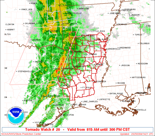
urgent - immediate broadcast requested
severe thunderstorm watch number 20...corrected
nws storm prediction center norman ok
1150 am cst wed mar 10 2010
corrected for cst vs cdt
the nws storm prediction center has issued a
severe thunderstorm watch for portions of
western arkansas
parts of northwest louisiana
eastern oklahoma
parts of northeast texas
effective this wednesday morning and afternoon from 1150 am until
500 pm cst.
hail to 2.5 inches in diameter...thunderstorm wind gusts to 70
mph...and dangerous lightning are possible in these areas.
the severe thunderstorm watch area is approximately along and 65
statute miles east and west of a line from 70 miles south
southeast of longview texas to 50 miles northwest of fayetteville
arkansas. for a complete depiction of the watch see the
associated watch outline update (wous64 kwns wou0).
remember...a severe thunderstorm watch means conditions are
favorable for severe thunderstorms in and close to the watch
area. persons in these areas should be on the lookout for
threatening weather conditions and listen for later statements
and possible warnings. severe thunderstorms can and occasionally
do produce tornadoes.
other watch information...continue...ww 19...
discussion...intense upper trough moving ewd across ok/n tx this
afternoon with rapidly destabilizing air mass across the watch area.
thunderstorms now ncentral tx/srn ok expected to intensify thru the
afternoon as they move/develop newd. with steep lapse rates and
mlcapes climbing to 1000 j/kg...threat of large hail and damaging
winds will increase.
aviation...a few severe thunderstorms with hail surface and aloft
to 2.5 inches. extreme turbulence and surface wind gusts to 60
knots. a few cumulonimbi with maximum tops to 450. mean storm
motion vector 24035.
owww...... dat komt akelig dicht bij mijn schoonouders in de buurt....
CLARKSVILLE... IDABEL... MT PLEASANT...
MT VERNON... PITTSBURG... QUITMAN... TYLER 1152 AM CST WED MAR 10 2010 .
NOW...
... A SEVERE THUNDERSTORM WATCH IS IN EFFECT UNTIL 5 PM...
SCATTERED SHOWERS AND ISOLATED THUNDERSTORMS EXTENDING TO THE WEST OF A LINE FROM VALLIANT OKLAHOMA TO ATHENS TEXAS WILL MOVE EAST NORTHEAST NEAR 35 MILES AN HOUR THIS AFTERNOON AND AFFECT PARTS OF THE AREA. SOME OF THE STORMS WILL LIKELY BECOME SEVERE WITH HIGH WINDS AND HAIL NOTED. EXPECT RAINFALL AMOUNTS NEAR ONE QUARTER OF AN INCH... THROUGH 2 PM.
| Gewijzigd: 10 maart 2010, 19:20 uur, door olivetomato
*** Shine on you crazy Diamond***

mesoscale discussion 0166
nws storm prediction center norman ok
1221 pm cst wed mar 10 2010
areas affected...cntrl/srn ms...w-cntrl/srn al
concerning...severe potential...tornado watch likely
valid 101821z - 101945z
threat for large hail and isolated tornadoes will increase this
afternoon with a tornado watch likely becoming needed.
low-topped convection has shown a gradual increase in
coverage/intensity across sern ms/swrn al nwwd into cntrl ms.
continued diurnal heating with surface temperatures warming into the
middle 70s and further destabilization should support isolated to
scattered tstm development during the afternoon. with region lying
on the ern fringe of steep mid-level lapse rates /per upstream
morning raobs and latest objective analysis/...severe hail would
likely be the primary threat. however...30-35 kt swly flow at 1 km
agl /per regional vwp data/ will be sufficient for low-level storm
rotation...and should be augmented be ambient shear along baroclinic
boundary lying roughly from around 40 sw cbm to near mgm as of 18z.
given the richness of boundary layer moisture with mean mixing
ratios around 12-13 g/kg /ref 18z lix raob/...isolated tornadoes
appear probable.
En een Tornado watch!
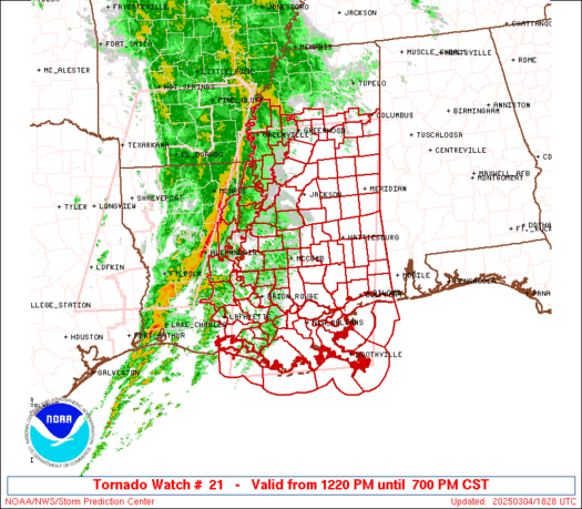
urgent - immediate broadcast requested
tornado watch number 21
nws storm prediction center norman ok
105 pm cst wed mar 10 2010
the nws storm prediction center has issued a
tornado watch for portions of
parts of central and southern alabama
parts of southern and eastern mississippi
effective this wednesday afternoon and evening from 105 pm until
800 pm cst.
tornadoes...hail to 2.5 inches in diameter...thunderstorm wind
gusts to 70 mph...and dangerous lightning are possible in these
areas.
the tornado watch area is approximately along and 75 statute
miles north and south of a line from 25 miles south of montgomery
alabama to 55 miles west northwest of meridian mississippi. for
a complete depiction of the watch see the associated watch
outline update (wous64 kwns wou1).
remember...a tornado watch means conditions are favorable for
tornadoes and severe thunderstorms in and close to the watch
area. persons in these areas should be on the lookout for
threatening weather conditions and listen for later statements
and possible warnings.
other watch information...continue...ww 19...ww 20...
discussion...thunderstorms are developing across the watch area in
response to surface heating and increasing instability. veering
shear profiles...particularly vicinity wnw/ese thermal boundary
from central ms to central al are favorable for supercell
development. steep mid level lapse rates and dry air as noted on
18z jan sounding are very favorable for large hail. also tornados
will be possible associated with any supercell that forms.
aviation...tornadoes and a few severe thunderstorms with hail
surface and aloft to 2.5 inches. extreme turbulence and surface
wind gusts to 60 knots. a few cumulonimbi with maximum tops to
500. mean storm motion vector 24025.
Update SPC
Het aantal supercells explodeerd momenteel, SPC heeft het 10% tornado gebied enorm uitgebreid. Hieronder is de huidige SPC Tornado Outlook te zien (20:00Z)
spc.noaa.gov
Tevens gelden er momenteel 3 Severe thunderstorm watches en 2 Tornado watches!
Klik hier voor alle actieve watches!
Update TVN; "Supercells explosing over southwest AR!"
Severe thunderstorms capable of tornadoes have initiated over the Arklatex region this afternoon, with a tornado warning currently in effect for Little River County including the town of Ashdown. Meanwhile, a tornado watch has been issued farther east, over areas of Mississippi and Alabama. It is expected that thunderstorms will continue to develop this afternoon and into the evening. An area stretching from Springfield, MO through western Arkansas into northern Louisiana is currently being monitored for development, with a tornado watch having just been issued for most of western AR. Multiple streamers are currently in the field, so be sure to follow along on the Live page!
Klik hier voor het volledige artikel (Tornadovideos.net) | Gewijzigd: 10 maart 2010, 22:52 uur, door Narmolanya
"Sunshine is delicious, rain is refreshing, wind braces us up and snow is exhilarating. There is really no such thing as bad weather, only different kinds of good weather."-John Ruskin
Radar-update
Er is momenteel een mooie "Hookecho" te zien op de radar! Hookecho's zijn kenmerkend voor de plaats van een tornado en bevinden zich vrijwel altijd aan de zuidkant van de bui. De storm lijkt niet erg intens, maar dat komt enkel omdat de bui zich momenteel op een dood punt bevind tussen verschillende doppler radars en dus bij alle radars op het randje van hun bereik ligt.
Aan de zuidkant van de bui is duidelijk een hook-echo te zien.
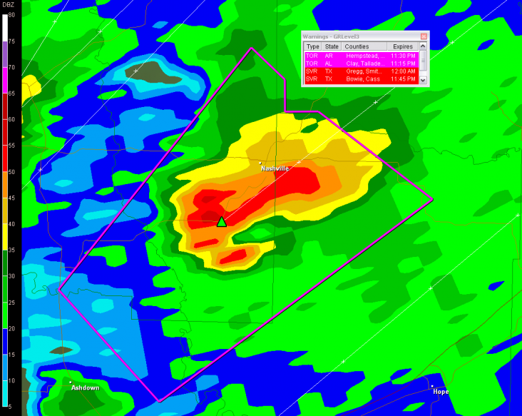 | Gewijzigd: 10 maart 2010, 23:11 uur, door Narmolanya
Er is momenteel een mooie "Hookecho" te zien op de radar! Hookecho's zijn kenmerkend voor de plaats van een tornado en bevinden zich vrijwel altijd aan de zuidkant van de bui. De storm lijkt niet erg intens, maar dat komt enkel omdat de bui zich momenteel op een dood punt bevind tussen verschillende doppler radars en dus bij alle radars op het randje van hun bereik ligt.
Aan de zuidkant van de bui is duidelijk een hook-echo te zien.
| Gewijzigd: 10 maart 2010, 23:11 uur, door Narmolanya
"Sunshine is delicious, rain is refreshing, wind braces us up and snow is exhilarating. There is really no such thing as bad weather, only different kinds of good weather."-John Ruskin
Het was lang wachten, maar er is eindelijk een tornado warning op een onweerscell, waar veel live-chasers aanwezig zijn!
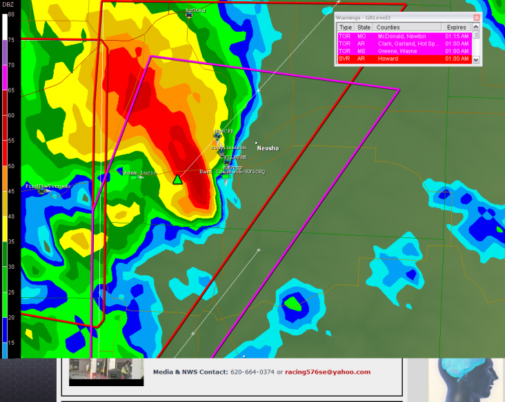
Edit:
Te vroeg gejuicht..
"The Tornado warning for western McDonald County is Cancelled..."
| Gewijzigd: 11 maart 2010, 00:47 uur, door Narmolanya
Edit:
Te vroeg gejuicht..
"The Tornado warning for western McDonald County is Cancelled..."
| Gewijzigd: 11 maart 2010, 00:47 uur, door Narmolanya
"Sunshine is delicious, rain is refreshing, wind braces us up and snow is exhilarating. There is really no such thing as bad weather, only different kinds of good weather."-John Ruskin

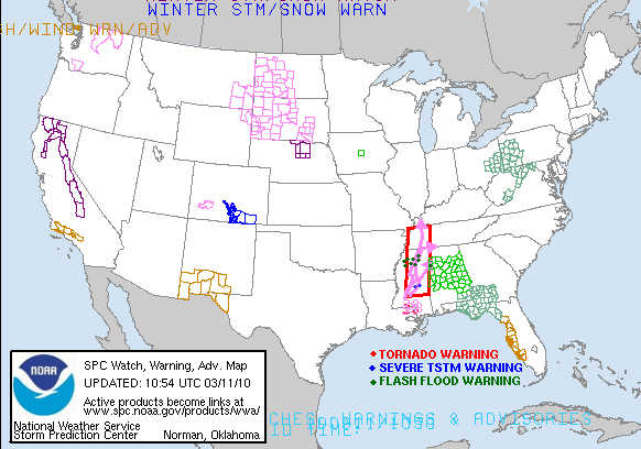
Update
Afgelopen nacht heeft het severe weather zoals verwacht flink huisgehouden. Ik heb de topictitel even aangepast, want voor komende dagen heeft het SPC alsnog geupgrade naar een Slight Risk. Vandaag krijgt Florida het stormsysteem voor zijn kiezen en vrijdag zullen Georgia, Alabama en zuid Florida het een en ander te verwerken krijgen. Tornado's zijn mogelijk, maar het grootste gevaar voor voor deze gebieden zijn de eventuele overstromingen die de felle regenbuien kunnen veroorzaken.
Momenteel geldt er nog een tornado watch in Mississippi, maar het SPC zal deze naar verwachting rond een uur of 2 intrekken. Stay tuned voor de gebruikelijke updates!
 | Gewijzigd: 11 maart 2010, 14:08 uur, door Sietse
Afgelopen nacht heeft het severe weather zoals verwacht flink huisgehouden. Ik heb de topictitel even aangepast, want voor komende dagen heeft het SPC alsnog geupgrade naar een Slight Risk. Vandaag krijgt Florida het stormsysteem voor zijn kiezen en vrijdag zullen Georgia, Alabama en zuid Florida het een en ander te verwerken krijgen. Tornado's zijn mogelijk, maar het grootste gevaar voor voor deze gebieden zijn de eventuele overstromingen die de felle regenbuien kunnen veroorzaken.
Momenteel geldt er nog een tornado watch in Mississippi, maar het SPC zal deze naar verwachting rond een uur of 2 intrekken. Stay tuned voor de gebruikelijke updates!
| Gewijzigd: 11 maart 2010, 14:08 uur, door Sietse
"Sunshine is delicious, rain is refreshing, wind braces us up and snow is exhilarating. There is really no such thing as bad weather, only different kinds of good weather."-John Ruskin
Nog eventjes wat kaartjes erbij:


Kans op tornado's:
Kans op zware windstoten:
Kans op grote hagel:
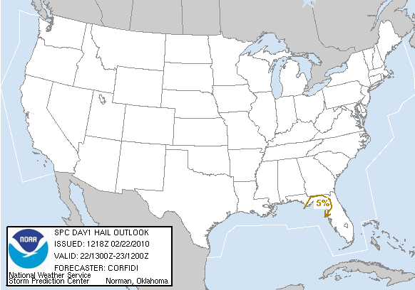
...synopsis...
broad upr cyclone centered over the lwr mo vly will persist over the
cntrl u.s this period as shortwave impulse now over az/nm continues
e/se to s tx and the lwr ms vly. farther s...subtropical jet also
will persist from s tx across the nrn gulf of mexico into nrn fl.
at the sfc...ia low will occlude over the upr ms vly as trailing
cold front decelerates over lwr portions of the oh...tn...and ms
vlys. a secondary low should form over the lwr ms vly later in the
period with the approach of az/nm upr impulse. in the mean
time...weak wave on w/e stnry front just s of the fl panhandle
should track e along the front across nrn fl to the ga cstl waters
by eve.
...fl and srn parts of the gulf coastal states today/tonight...
40+ kt swly llj associated with aforementioned sfc wave and beneath
exit region of strong subtropical jet will shift e across the nern
gulf and the fl peninsula today. this will allow fairly rich
moisture /sfc dewpoints in the mid 60s f and pw aoa 1.50 in/ to
overspread nrn and cntrl fl s of stalled w/e front/rain-reinforced
boundary. weak mid lvl lapse rates and clouds
will...however...limit sbcape to aob 1000 j/kg.
loosely-organized convective system now over the cntrl fl panhandle
swd into the nern gulf expected to move/develop slowly ewd with
associated sfc wave through the day. additional showers/storms
likely will form s and e of the mcs in response to sfc heating of
moist/confluent flow over the fl peninsula.
despite modest cape...given increasingly moist low-lvl environment
and degree of both low-lvl and deep shear...setup will support short
lines/clusters of storms with embedded lewps/supercells. these may
produce both tornadoes and dmgg wind given strength of lwr
tropospheric flow and large low-lvl hodographs...especially during
the aftn. while the svr threat may diminish this eve...the threat
may increase again later tonight/early fri as the llj redevelops
ahead of approaching upr impulse.
..mid ms/lwr oh vlys this aftn...
lobe of ascent rotating around mo vly closed low will move across
the il area later this morning/early this aftn...atop narrow
corridor of low lvl moisture /dewpoints in the lwr 50s f and pw
around 1 in/. sfc heating in associated dry slot may boost sbcape
to around 750 j/kg given cool mid lvl temperatures. setup may
support early aftn development of storms along secondary cold front
now over e cntrl mo as the boundary moves e of the ms rvr.
however...12z sgf raob and some model thermal forecasts suggest that
a warm layer might move into the region around the 700 mb lvl that
could limit development. at any rate...although wind profiles will
not be very conducive to supercells...given the thermodynamic
environment...one or two bands of strong storms may form if warm
layer is breached. these could yield hail and perhaps a spinup-type
tornado or two. any such threat should end later in the day.
...lwr ms and tn vlys late...
trailing portion of stalling cold front may serve as a focus for
storm development late tonight/early fri as ascent with az/nm upr
impulse overtakes moist axis likely to remain present e of the ms
rvr. coupled with steep mid lvl lapse rates and moderate to strong
deep shear...storms may yield large hail and possibly dmgg wind as
they consolidate into one or two clusters.
Bron: spc.noaa.gov/Accuweather
Kans op tornado's:
Kans op zware windstoten:
Kans op grote hagel:
...synopsis...
broad upr cyclone centered over the lwr mo vly will persist over the
cntrl u.s this period as shortwave impulse now over az/nm continues
e/se to s tx and the lwr ms vly. farther s...subtropical jet also
will persist from s tx across the nrn gulf of mexico into nrn fl.
at the sfc...ia low will occlude over the upr ms vly as trailing
cold front decelerates over lwr portions of the oh...tn...and ms
vlys. a secondary low should form over the lwr ms vly later in the
period with the approach of az/nm upr impulse. in the mean
time...weak wave on w/e stnry front just s of the fl panhandle
should track e along the front across nrn fl to the ga cstl waters
by eve.
...fl and srn parts of the gulf coastal states today/tonight...
40+ kt swly llj associated with aforementioned sfc wave and beneath
exit region of strong subtropical jet will shift e across the nern
gulf and the fl peninsula today. this will allow fairly rich
moisture /sfc dewpoints in the mid 60s f and pw aoa 1.50 in/ to
overspread nrn and cntrl fl s of stalled w/e front/rain-reinforced
boundary. weak mid lvl lapse rates and clouds
will...however...limit sbcape to aob 1000 j/kg.
loosely-organized convective system now over the cntrl fl panhandle
swd into the nern gulf expected to move/develop slowly ewd with
associated sfc wave through the day. additional showers/storms
likely will form s and e of the mcs in response to sfc heating of
moist/confluent flow over the fl peninsula.
despite modest cape...given increasingly moist low-lvl environment
and degree of both low-lvl and deep shear...setup will support short
lines/clusters of storms with embedded lewps/supercells. these may
produce both tornadoes and dmgg wind given strength of lwr
tropospheric flow and large low-lvl hodographs...especially during
the aftn. while the svr threat may diminish this eve...the threat
may increase again later tonight/early fri as the llj redevelops
ahead of approaching upr impulse.
..mid ms/lwr oh vlys this aftn...
lobe of ascent rotating around mo vly closed low will move across
the il area later this morning/early this aftn...atop narrow
corridor of low lvl moisture /dewpoints in the lwr 50s f and pw
around 1 in/. sfc heating in associated dry slot may boost sbcape
to around 750 j/kg given cool mid lvl temperatures. setup may
support early aftn development of storms along secondary cold front
now over e cntrl mo as the boundary moves e of the ms rvr.
however...12z sgf raob and some model thermal forecasts suggest that
a warm layer might move into the region around the 700 mb lvl that
could limit development. at any rate...although wind profiles will
not be very conducive to supercells...given the thermodynamic
environment...one or two bands of strong storms may form if warm
layer is breached. these could yield hail and perhaps a spinup-type
tornado or two. any such threat should end later in the day.
...lwr ms and tn vlys late...
trailing portion of stalling cold front may serve as a focus for
storm development late tonight/early fri as ascent with az/nm upr
impulse overtakes moist axis likely to remain present e of the ms
rvr. coupled with steep mid lvl lapse rates and moderate to strong
deep shear...storms may yield large hail and possibly dmgg wind as
they consolidate into one or two clusters.
Bron: spc.noaa.gov/Accuweather
“There is no such thing as bad weather, only different kinds of good weather.â€ÂMijn Weerblog