Berichtgeving dodelijke tornado-uitbraak USA 25-30 april 2014
Storm en wind

Tornado's eisen doden in Verenigde Staten
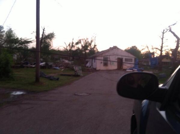
Een tornado heeft in de Amerikaanse staten Oklahoma en Arkansas aan dertien mensen het leven gekost. Twee doden zijn gevallen in het stadje Quapaw, in de staat Oklahoma. Het noorden van het dorp zou zwaar zijn beschadigd door de tornado.
Daken zijn daar van de gebouwen gerukt en een brandweerkazerne is compleet weggevaagd, meldt CBS News.
In het stadje Vilonia, in Arkansas, kwamen twee mensen om het leven. Reddingswerkers zijn nog op zoek naar meer slachtoffers in de ravage die de tornado's hebben achtergelaten. Zo werden veel gebouwen uit elkaar gerukt, waarna de brokstukken in de omgeving zijn neergekomen.
Nabij het stadje Mayflower, in dezelfde staat, kwam één persoon om het leven en in Pulaski County vielen drie slachtoffers. Bomen en elektriciteitspalen zijn uit de grond gerukt, waardoor op sommige plaatsen de elektriciteit is uitgevallen.
Ook de staten Kansas en Missouri worden geteisterd door zwaar noodweer en tornado's. Zo is in Missouri een vrachtwagen van de weg geblazen. Op veel plekken zijn tornadowaarschuwingen afgegeven.
Snelweg
Door de storm moest de belangrijke snelweg I-40, die van de oost- naar de westkust loopt, worden afgesloten. Het asfalt is onder meer bij Mayflower bezaaid met puin.
De tornado's komen voort uit een groot stormfront dat al dagen over het zuiden en midwesten van de Verenigde Staten trekt. Daardoor zijn op voorhand op veel plaatsen tornadowaarschuwingen afgegeven.
De Amerikaanse president Obama heeft intussen zijn medeleven betuigd aan de familie van de dodelijke slachtoffers van het noodweer. Hij beloofde ook overheidshulp bij de wederopbouw van de vernielde huizen. "Jullie land zal er zijn om jullie daar bij te helpen, zo lang als dat nodig zou zijn", klonk het.
Bron: NU/De Redactie | Gewijzigd: 28 april 2014, 11:15 uur, door Debbieke
Mijn twitter: https://twitter.com/#!/debbietje128
Onweersdagen: 0
Onweersdagen: 0


Bizar weerbeeld voor vandaag, daar waar de depressie in het zuiden vandaag opnieuw voor extreem weer zorgt, krijgen ze in het noorden te maken met zware sneeuwval door de zelfde depressie.

Freedom is not worth having if it does not include the freedom to make mistakes.
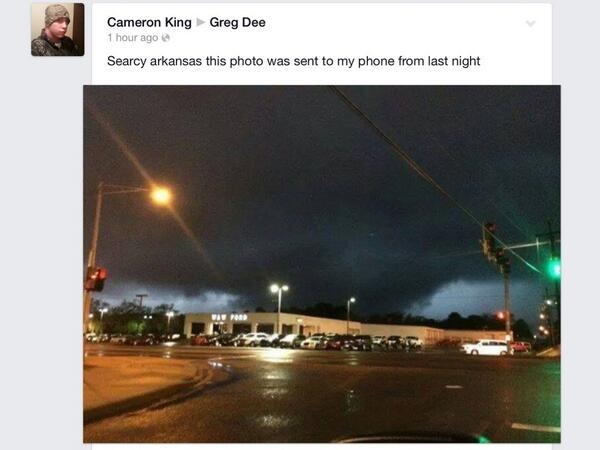
Kan iemand mij bvertellen wat dit geweest is?

![[t]](/images/smilies/t.gif "[t]") Sammy Weather Center @SaWeCe
Sammy Weather Center @SaWeCe
Increible los daños en la I-40, en #MayFlowerArkansas, tras el #tornado devastador que afectó ayer
Het antwoord: @mikeseidel: Three big RVs wrapped around a twisted I-40 billboard in Mayflower, #AR. pic.twitter.com/8g7yHg6Ftr #tornado | Gewijzigd: 28 april 2014, 15:54 uur, door Marga
Increible los daños en la I-40, en #MayFlowerArkansas, tras el #tornado devastador que afectó ayer
Het antwoord: @mikeseidel: Three big RVs wrapped around a twisted I-40 billboard in Mayflower, #AR. pic.twitter.com/8g7yHg6Ftr #tornado | Gewijzigd: 28 april 2014, 15:54 uur, door Marga
Every cloud has a silver lining

Amazing 3D radar image of the #Tornado moving through El Paso, Arkansas.. so much debris

Vilonia, Arkansas #Tornado is throwing debris about 15,000ft in the air #arwx | Gewijzigd: 28 april 2014, 16:12 uur, door Marga
Every cloud has a silver lining
Just wow | PIC: intact house in the middle of the road in Baxter Springs, KS after #tornado [via Amber Smith] #KSwx

PICTURE: Home in the middle of a street from earlier #tornado in Baxter Springs, #KS via @NewsOn6 #kswx | Gewijzigd: 28 april 2014, 16:07 uur, door Marga
Every cloud has a silver lining


Tornadoes/Flooding on April 27-28, 2014

In the picture: It became stormy in Arkansas ahead of a storm system ("L") and cold front on 04/27/2014.
A powerful storm system entered the Plains from the Rockies early on April 27th. The system dragged a cold front toward the region, and thunderstorms became likely. This event looked ominous, and was expected to become the largest severe weather episode so far this spring. Strong tornadoes (at least EF2) and very large hail (bigger than golfballs) were anticipated.

In the picture: The Day 1 categorical outlook for 04/27/2014 called for a moderate to high risk of severe weather over much of Arkansas. The forecast is courtesy of the Storm Prediction Center.
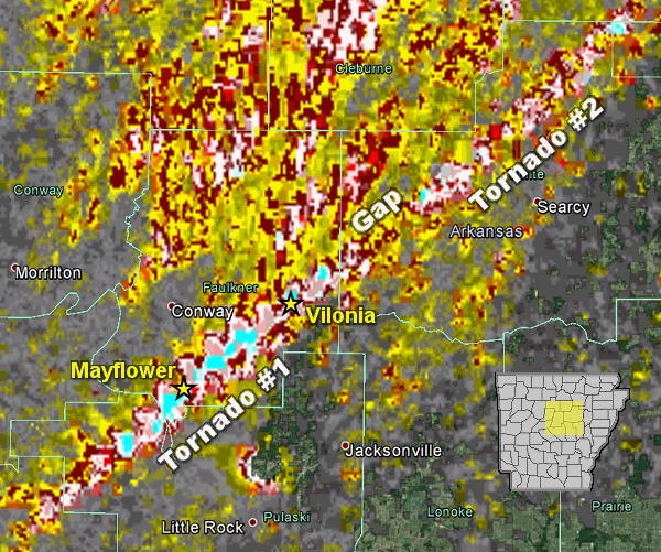
In the picture: Rotation associated with the parent storm on 04/27/2014 was persistent for roughly 40 miles (Tornado #1) before weakening (where the gap is indicated). Another tornado (Tornado #2) was likely spawned a short time later by the same storm and tracked through White, Jackson, and Independence Counties. Note: Tornado #2 may actually be several tornadoes. This will be determined through damage surveys. The graphic is courtesy of the National Severe Storms Laboratory.
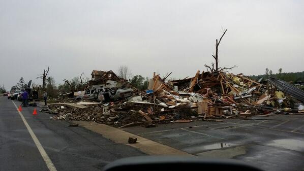
While this did not turn into an outbreak of severe weather, the ferocity of at least one storm was realized. Just after 700 pm CDT, a supercell (storm with rotating updrafts) rapidly intensified northwest of the Little Rock (Pulaski County) area. A destructive tornado was produced, with the tornado tracking through Mayflower and Vilonia (both in Faulkner County) before apparently dissipating (according to radar) near El Paso (White County).

In the pictures: The WSR-88D (Doppler Weather Radar) showed strong rotation between Mayflower and Vilonia (both in Faulkner County) at 738 pm CDT on 04/27/2014. There was also a debris ball present, which is a very good indicator of a tornado causing damage.
Along the way, houses and businesses were heavily damaged or reduced to rubble. As of the morning of the 28th, there were14 fatalities reported. If this number is correct, it would be the deadliest single tornado since the Interstate 30 twister (rated F4) that killed 15 people in Saline and Pulaski Counties on March 1, 1997.
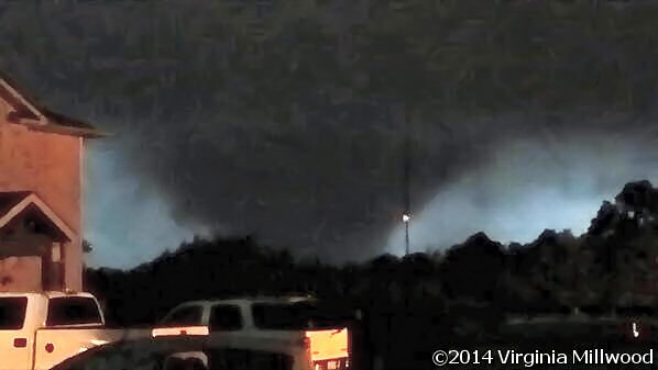
In the picture: A wedge tornado was witnessed at Vilonia (Faulkner County) during the evening of 04/27/2014. The photo is courtesy of Virginia Millwood.
Farther northeast, it appears the parent storm dropped one or several more tornadoes that headed toward Center Hill (White County), Denmark (White/Jackson County line) and Jacksonport (Jackson County).
All damage will be surveyed in the coming days by the National Weather Service to determine the tornado count and also the magnitude of the tornadoes.
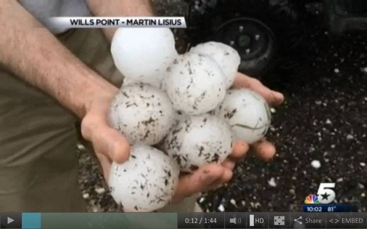
Before the tornadoes, there was very large hail in the northern half of the state. Tennis ball size hail hit Henderson (Baxter County), with ping pong to golf ball size hail at Dover (Pope County), near Waldron (Scott County) and south of Marshall (Searcy County). This happened between 400 pm and 700 pm CDT.
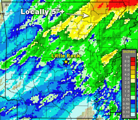
In the picture: Twenty four hour rainfall through 700 am CDT on 04/28/2014.
The other significant part of this story was the rain. There was a lot of it in northeast Arkansas. Locally more than five inches of water was measured in the twenty four hour period ending at 700 am CDT on 04/28/2014. This included a whopping 7.60 inches at Batesville Lock and Dam (Independence County) and Beedeville (Jackson County), 6.10 inches at Calamine (Sharp County), 6.03 inches at Corning (Clay County), 5.34 inches at Evening Shade (Sharp County), 5.30 inches at Ravenden Springs (Randolph County), 5.20 inches at Pocahontas (Randolph County) and 5.05 inches at Melbourne (Izard County).
This much rain caused extensive flash flooding, with numerous roads under water. There was a mudslide on Highway 25 southwest of Desha (Independence County). A bridge was submerged (likely by a creek) along Highway 25 between Batesville and Moorefield (Independence County). Highway 69 was flooded at Mount Pleasant (Izard County).
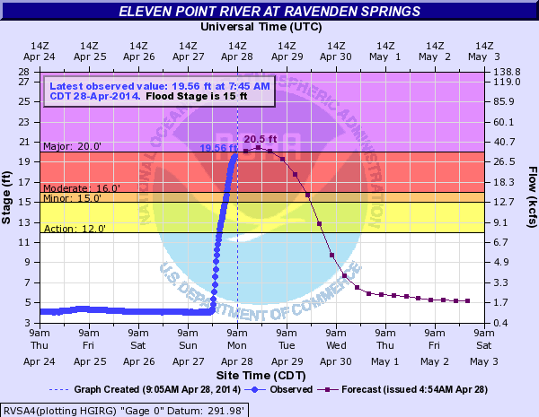
In the picture: The hydrograph for the Eleven Point River at Ravenden Springs (Randolph County) projected major flooding by the afternoon of 04/28/2014.
Small rivers and streams were on the rise in the northeast, with moderate to major flooding projected along the Spring River at Hardy (Sharp County) and the Eleven Point River at Ravenden Springs (Randolph County).
Stormreports
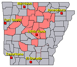
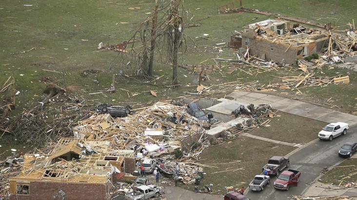
In the picture: Preliminary reports of severe weather and flooding in the Little Rock County Warning Area on April 27-28, 2014 (in red).


Bron: NWS, Little Rock, Arkansas
In the picture: It became stormy in Arkansas ahead of a storm system ("L") and cold front on 04/27/2014.
A powerful storm system entered the Plains from the Rockies early on April 27th. The system dragged a cold front toward the region, and thunderstorms became likely. This event looked ominous, and was expected to become the largest severe weather episode so far this spring. Strong tornadoes (at least EF2) and very large hail (bigger than golfballs) were anticipated.
In the picture: The Day 1 categorical outlook for 04/27/2014 called for a moderate to high risk of severe weather over much of Arkansas. The forecast is courtesy of the Storm Prediction Center.
In the picture: Rotation associated with the parent storm on 04/27/2014 was persistent for roughly 40 miles (Tornado #1) before weakening (where the gap is indicated). Another tornado (Tornado #2) was likely spawned a short time later by the same storm and tracked through White, Jackson, and Independence Counties. Note: Tornado #2 may actually be several tornadoes. This will be determined through damage surveys. The graphic is courtesy of the National Severe Storms Laboratory.
While this did not turn into an outbreak of severe weather, the ferocity of at least one storm was realized. Just after 700 pm CDT, a supercell (storm with rotating updrafts) rapidly intensified northwest of the Little Rock (Pulaski County) area. A destructive tornado was produced, with the tornado tracking through Mayflower and Vilonia (both in Faulkner County) before apparently dissipating (according to radar) near El Paso (White County).
In the pictures: The WSR-88D (Doppler Weather Radar) showed strong rotation between Mayflower and Vilonia (both in Faulkner County) at 738 pm CDT on 04/27/2014. There was also a debris ball present, which is a very good indicator of a tornado causing damage.
Along the way, houses and businesses were heavily damaged or reduced to rubble. As of the morning of the 28th, there were14 fatalities reported. If this number is correct, it would be the deadliest single tornado since the Interstate 30 twister (rated F4) that killed 15 people in Saline and Pulaski Counties on March 1, 1997.
In the picture: A wedge tornado was witnessed at Vilonia (Faulkner County) during the evening of 04/27/2014. The photo is courtesy of Virginia Millwood.
Farther northeast, it appears the parent storm dropped one or several more tornadoes that headed toward Center Hill (White County), Denmark (White/Jackson County line) and Jacksonport (Jackson County).
All damage will be surveyed in the coming days by the National Weather Service to determine the tornado count and also the magnitude of the tornadoes.
Before the tornadoes, there was very large hail in the northern half of the state. Tennis ball size hail hit Henderson (Baxter County), with ping pong to golf ball size hail at Dover (Pope County), near Waldron (Scott County) and south of Marshall (Searcy County). This happened between 400 pm and 700 pm CDT.
In the picture: Twenty four hour rainfall through 700 am CDT on 04/28/2014.
The other significant part of this story was the rain. There was a lot of it in northeast Arkansas. Locally more than five inches of water was measured in the twenty four hour period ending at 700 am CDT on 04/28/2014. This included a whopping 7.60 inches at Batesville Lock and Dam (Independence County) and Beedeville (Jackson County), 6.10 inches at Calamine (Sharp County), 6.03 inches at Corning (Clay County), 5.34 inches at Evening Shade (Sharp County), 5.30 inches at Ravenden Springs (Randolph County), 5.20 inches at Pocahontas (Randolph County) and 5.05 inches at Melbourne (Izard County).
This much rain caused extensive flash flooding, with numerous roads under water. There was a mudslide on Highway 25 southwest of Desha (Independence County). A bridge was submerged (likely by a creek) along Highway 25 between Batesville and Moorefield (Independence County). Highway 69 was flooded at Mount Pleasant (Izard County).
In the picture: The hydrograph for the Eleven Point River at Ravenden Springs (Randolph County) projected major flooding by the afternoon of 04/28/2014.
Small rivers and streams were on the rise in the northeast, with moderate to major flooding projected along the Spring River at Hardy (Sharp County) and the Eleven Point River at Ravenden Springs (Randolph County).
Stormreports
In the picture: Preliminary reports of severe weather and flooding in the Little Rock County Warning Area on April 27-28, 2014 (in red).
Bron: NWS, Little Rock, Arkansas
Every cloud has a silver lining
Tornado Storm System Captured by Weather Satellites
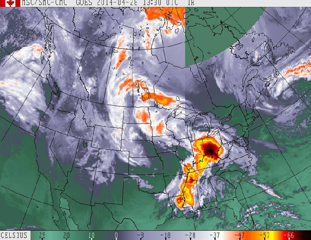
An infrared satellite image acquired by the Cooperative Institute for Meteorological Satellite Studies (CIMSS) shows the complex thunderstorm system that produced at least 31 tornadoes through the Plains and South on Sunday, leaving at least 18 people dead.

Bron: Nbc
An infrared satellite image acquired by the Cooperative Institute for Meteorological Satellite Studies (CIMSS) shows the complex thunderstorm system that produced at least 31 tornadoes through the Plains and South on Sunday, leaving at least 18 people dead.
Bron: Nbc
Every cloud has a silver lining
Baxter Springs, Kansas
A home is covered by debris from a tornado in Baxter Springs, Kan., Monday, April 28, 2014. (AP Photo/Orlin Wagner)
The remains of a home damaged by a tornado Sunday evening stands in Baxter Springs, Kan., Monday, April 28, 2014. (AP Photo/Orlin Wagner)

Bob Hessee checks out property owned by a friend and damaged by a tornado in Baxter Springs, Kan., Monday, April 28, 2014. (AP Photo/Orlin Wagner)
Mayflower
Bob Hessee checks out property owned by a friend and damaged by a tornado in Baxter Springs, Kan., Monday, April 28, 2014. (AP Photo/Orlin Wagner)

A twisted power distribution line tower is crumpled on the ground near Mayflower, Ark., Monday, April 28, 2014 after a tornado struck the town late Sunday. (AP Photo/Danny Johnston)

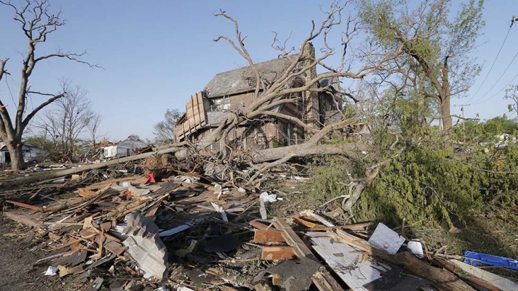
Houses are destroyed in Mayflower, Ark., Monday, April 28, 2014, after a tornado struck the town late Sunday. (AP Photo/Danny Johnston)
Vilonia
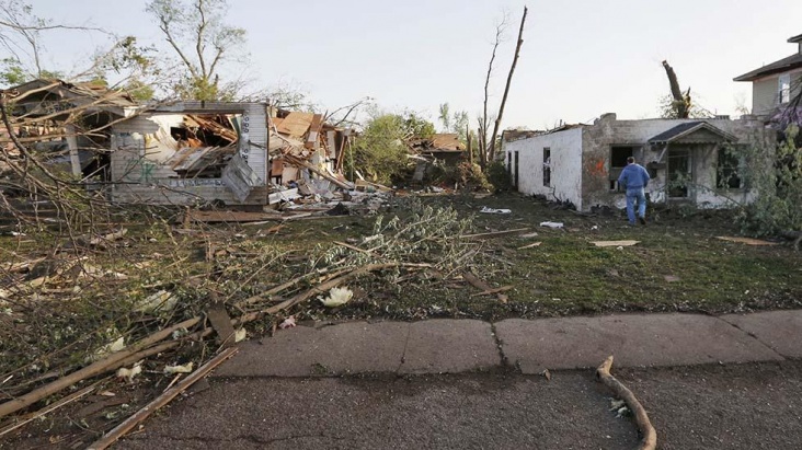
A concrete slab and rubble are all that is left of a home in Vilonia, Ark., neighborhood Monday, April 28, 2014, after a tornado struck the town late Sunday. (AP Photo/Danny Johnston)

A row of lightly damages houses, top, face destroyed homes in a Vilonia, Ark., neighborhood Monday, April 28, 2014 after a tornado struck the town late Sunday, killing at least 16 people. (AP Photo/Danny Johnston)
Homes and businesses are wrecked in downtown Vilonia, Ark., Monday, April 28, 2014 after a tornado struck the town late Sunday. (AP Photo/Danny Johnston

Voor een groot aantal foto's >> klik hier << | Gewijzigd: 28 april 2014, 19:32 uur, door Marga
A home is covered by debris from a tornado in Baxter Springs, Kan., Monday, April 28, 2014. (AP Photo/Orlin Wagner)
The remains of a home damaged by a tornado Sunday evening stands in Baxter Springs, Kan., Monday, April 28, 2014. (AP Photo/Orlin Wagner)
Bob Hessee checks out property owned by a friend and damaged by a tornado in Baxter Springs, Kan., Monday, April 28, 2014. (AP Photo/Orlin Wagner)
Mayflower
Bob Hessee checks out property owned by a friend and damaged by a tornado in Baxter Springs, Kan., Monday, April 28, 2014. (AP Photo/Orlin Wagner)
A twisted power distribution line tower is crumpled on the ground near Mayflower, Ark., Monday, April 28, 2014 after a tornado struck the town late Sunday. (AP Photo/Danny Johnston)
Houses are destroyed in Mayflower, Ark., Monday, April 28, 2014, after a tornado struck the town late Sunday. (AP Photo/Danny Johnston)
Vilonia
A concrete slab and rubble are all that is left of a home in Vilonia, Ark., neighborhood Monday, April 28, 2014, after a tornado struck the town late Sunday. (AP Photo/Danny Johnston)
A row of lightly damages houses, top, face destroyed homes in a Vilonia, Ark., neighborhood Monday, April 28, 2014 after a tornado struck the town late Sunday, killing at least 16 people. (AP Photo/Danny Johnston)
Homes and businesses are wrecked in downtown Vilonia, Ark., Monday, April 28, 2014 after a tornado struck the town late Sunday. (AP Photo/Danny Johnston
Voor een groot aantal foto's >> klik hier << | Gewijzigd: 28 april 2014, 19:32 uur, door Marga
Every cloud has a silver lining